Yorktown Heights, New York

Last updated

Yorktown Heights, New York
Former Yorktown Heights, NY, railroad station.jpg
Westchester County New York incorporated and unincorporated areas Yorktown Heights highlighted.svg
Location of Yorktown Heights, New York
Coordinates: 41°16′38″N73°46′53″W / 41.27722°N 73.78139°W / 41.27722; -73.78139
Country United States
State New York
County Westchester
Town Yorktown
Area
[1]
  Total0.92 sq mi (2.39 km2)
  Land0.92 sq mi (2.38 km2)
  Water0.00 sq mi (0.01 km2)
Elevation
492 ft (150 m)
Population
 (2020)
  Total1,884
  Density2,050.05/sq mi (791.81/km2)
Time zone UTC-5 (Eastern (EST))
  Summer (DST) UTC-4 (EDT)
ZIP code
10598
Area code 914
FIPS code 36-84088 [2]
GNIS feature ID0971839 [3]
Website www.yorktownny.org

Yorktown Heights is a census-designated place (CDP) in the town of Yorktown in Westchester County, New York, United States. The population was 1,781 at the 2010 census. [4]

Contents

History

Yorktown Heights is in the town of Yorktown, New York, in northern Westchester County, 45 miles from New York City, with forty square miles of rolling hills, farmland, residential areas and light industry including the IBM Thomas J. Watson Research Center. First settled in 1683, Yorktown was of strategic importance during the American Revolution, with the Pines Bridge crossing of the Croton River guarded by the 1st Rhode Island Regiment, an integrated unit which included African Americans and Native Americans. Yorktown was incorporated in 1788 and named in commemoration of the Franco-American decisive victory at Yorktown, Virginia. The Yorktown Heights Railroad Station, which last had passenger service on the New York Central Railroad's Putnam Division in 1958, was added to the National Register of Historic Places in 1981. [5]

Geography

Yorktown Heights is at 41°16′38″N73°46′53″W / 41.27722°N 73.78139°W / 41.27722; -73.78139 (41.277347, −73.781290). [6]

The Yorktown Heights Census-designated place (CDP) has a total area of 0.93 square miles (2.4 km2), all land. [7]

Like much of northern Westchester County, Yorktown is largely hilly and wooded.

Climate

Climate data for Yorktown Heights, New York
MonthJanFebMarAprMayJunJulAugSepOctNovDecYear
Record high °F (°C)67
(19)
73
(23)
85
(29)
95
(35)
94
(34)
94
(34)
100
(38)
100
(38)
95
(35)
87
(31)
79
(26)
73
(23)
100
(38)
Mean daily maximum °F (°C)35.5
(1.9)
38.6
(3.7)
46.8
(8.2)
59.7
(15.4)
69.6
(20.9)
78.0
(25.6)
83.0
(28.3)
81.1
(27.3)
74.4
(23.6)
62.5
(16.9)
51.4
(10.8)
40.8
(4.9)
60.1
(15.6)
Mean daily minimum °F (°C)16.7
(−8.5)
17.9
(−7.8)
25.4
(−3.7)
35.9
(2.2)
47.8
(8.8)
55.2
(12.9)
60.8
(16.0)
59.3
(15.2)
51.9
(11.1)
40.9
(4.9)
31.5
(−0.3)
23.3
(−4.8)
38.9
(3.8)
Record low °F (°C)−15
(−26)
−10
(−23)
0
(−18)
14
(−10)
30
(−1)
38
(3)
46
(8)
39
(4)
32
(0)
20
(−7)
11
(−12)
−9
(−23)
−15
(−26)
Average precipitation inches (mm)3.72
(94)
3.06
(78)
4.10
(104)
3.89
(99)
3.91
(99)
5.00
(127)
4.32
(110)
4.28
(109)
4.80
(122)
4.61
(117)
4.24
(108)
4.37
(111)
50.30
(1,278)
Average snowfall inches (cm)8.8
(22)
12.6
(32)
8.2
(21)
1.8
(4.6)
0
(0)
0
(0)
0
(0)
0
(0)
0
(0)
0
(0)
0.5
(1.3)
7.6
(19)
39.50
(100.3)
Average precipitation days11.18.610.511.111.611.310.39.98.99.49.110.5122.3
Average snowy days5.24.13.30.40000000.53.416.9
Source: NOAA [8]

Demographics

Historical population
CensusPop.Note
2020 1,884
U.S. Decennial Census [9]

As of the census [2] of 2000, there were 7,972 people, 2,629 households, and 2,163 families residing in the CDP. The population density was 1,399.3/mi2 (540.0/km2). There were 2,661 housing units at an average density of 467.1/mi2 (180.2/km2). The racial makeup of the CDP was 90.49% White, 2.41% African American, 0.06% Native American, 4.69% Asian, 0.01% Pacific Islander, 0.85% from other races, and 1.48% from two or more races. Hispanic or Latino of any race were 5.59% of the population.

There were 2,629 households, out of which 44.6% had children under the age of 18 living with them, 73.0% were married couples living together, 7.2% had a female householder with no husband present, and 17.7% were non-families. 15.3% of all households were made up of individuals, and 9.0% had someone living alone who was 65 years of age or older. The average household size was 3.02 and the average family size was 3.37.

In the CDP, the population was spread out, with 28.4% under the age of 18, 5.8% from 18 to 24, 27.1% from 25 to 44, 27.4% from 45 to 64, and 11.3% who were 65 years of age or older. The median age was 39 years. For every 100 females, there were 95.9 males. For every 100 females age 18 and over, there were 90.6 males.

The median income for a household in the CDP was $108,648, and the median income for a family was $137,580. Males had a median income of $91,365 versus $80,261 for females. The per capita income for the CDP was $41,349.

Landmarks

Yorktown Heights possesses many historical landmarks, specifically related to Colonial times and the Revolutionary War. They include the Hyatt House, Lanes Tavern, and one of the first Presbyterian churches in the region. Another landmark famous to the town is the former railroad station, which was built in 1905, and had been a stop on the New York and Putnam Railroad Line (also called the "Old Put"). A popular hiking destination is Turkey Mountain, maintained by the Yorktown Land Trust. The North County Trailway is a popular running and bike path that can be accessed from Yorktown Heights.

Transportation

U.S. Route 202 passes through Yorktown Heights. The Taconic State Parkway is nearby, to the west.

Yorktown Heights Railroad Station was closed in 1958, a year before passenger service was abandoned along the New York Central's Putnam Division.

Notable people

Related Research Articles

<span class="mw-page-title-main">Westchester, Florida</span> Census-designated place in Florida

Westchester is a census-designated place (CDP) and neighborhood in Miami-Dade County, Florida. It is part of the Miami metropolitan area of South Florida. Prior to the 2020 U.S. Census, the neighboring University Park CDP was merged into Westchester CDP, effectively doubling its geography and population. Per the 2020 census, the population was 56,384.

<span class="mw-page-title-main">Marshfield Hills, Massachusetts</span> Census-designated place in Massachusetts, United States

Marshfield Hills is a census-designated place (CDP) in the town of Marshfield in Plymouth County, Massachusetts, United States. The population was 2,356 at the 2010 census. The historic center of the village has been designated a historic district and listed on the National Register of Historic Places.

<span class="mw-page-title-main">Crown Heights, New York</span> Census-designated place in New York, United States

Crown Heights is a hamlet and census-designated place (CDP) in Dutchess County, New York, United States. The population was 2,840 at the 2010 census. It is part of the Poughkeepsie–Newburgh–Middletown, NY Metropolitan Statistical Area as well as the larger New York–Newark–Bridgeport, NY-NJ-CT-PA Combined Statistical Area.

<span class="mw-page-title-main">Hopewell Junction, New York</span> Census-designated place in New York, United States

Hopewell Junction is a hamlet and census-designated place (CDP) in Dutchess County, New York, United States. The population was 1330 at the 2020 census. It is part of the Poughkeepsie–Newburgh–Middletown, NY Metropolitan Statistical Area as well as the larger New York–Newark–Bridgeport, NY-NJ-CT-PA Combined Statistical Area.

<span class="mw-page-title-main">Spackenkill, New York</span> Census-designated place in New York, United States

Spackenkill is a hamlet and census-designated place (CDP) in Dutchess County, New York, United States. The population was 4,123 at the 2010 census. It is part of the Poughkeepsie–Newburgh–Middletown, NY Metropolitan Statistical Area as well as the larger New York–Newark–Bridgeport, NY-NJ-CT-PA Combined Statistical Area.

<span class="mw-page-title-main">Carmel Hamlet, New York</span> Hamlet and Census-designated place in New York, United States

Carmel Hamlet, commonly known simply as Carmel, is a hamlet and census-designated place (CDP) located in the Town of Carmel in Putnam County, New York, United States. As of the 2010 census, the population was 6,817.

<span class="mw-page-title-main">Cortlandt, New York</span> Town in New York, United States

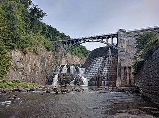
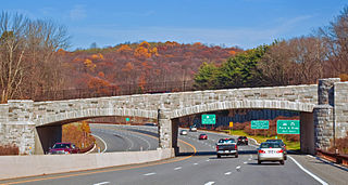
Cortlandt is a town in Westchester County, New York, United States, located at the northwestern edge of the county, at the eastern terminus of the Bear Mountain Bridge. The town includes the villages of Buchanan and Croton-on-Hudson.

<span class="mw-page-title-main">Crompond, New York</span> CDP in New York, United States

Crompond is a hamlet and census-designated place (CDP) located in the town of Yorktown in Westchester County, New York, United States. The population was 2,292 at the 2010 census.

<span class="mw-page-title-main">Crugers, New York</span> Hamlet and census-designated place in Cortlandt, New York

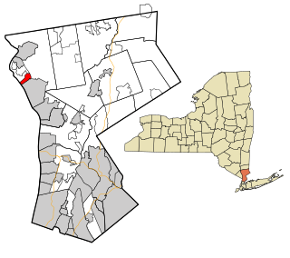
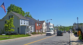
Crugers is a hamlet and census-designated place (CDP) located in the town of Cortlandt, Westchester County, New York, United States. The population was 1,534 at the 2010 census.

<span class="mw-page-title-main">Elmsford, New York</span> Village in New York, United States

Elmsford is a village in Westchester County, New York, United States. It is part of the New York metropolitan area. Roughly one square mile, the village is fully contained within the borders of the town of Greenburgh. As of the 2010 census, the population of Elmsford was 4,664.

<span class="mw-page-title-main">Fairview, Westchester County, New York</span> CDP in New York, United States

Fairview is a hamlet and a census-designated place (CDP) located in the town of Greenburgh, Westchester County, New York, United States. The population was 3,099 at the 2010 census. As of 2000, Fairview had the fourth-highest percentage of African-Americans in New York.

<span class="mw-page-title-main">Mohegan Lake, New York</span> CDP in New York, United States

Lake Mohegan, commonly known as Mohegan Lake, is a census-designated place (CDP) located in the Town of Yorktown in Westchester County, New York, United States.

<span class="mw-page-title-main">Shrub Oak, New York</span> CDP in New York, United States

Shrub Oak is an unincorporated hamlet and census-designated place (CDP) located in the town of Yorktown in Westchester County, New York, United States. The population was 2,011 at the 2010 census.

<span class="mw-page-title-main">Yorktown, New York</span> Town in New York, United States

Yorktown is a town on the northern border of Westchester County, New York, United States. A suburb of the New York City metropolitan area, it is approximately 38 miles (61 km) north of midtown Manhattan. The population was 36,569 at the 2020 U.S. Census.

<span class="mw-page-title-main">Greenville, Rhode Island</span> Census-designated place in Rhode Island, United States

Greenville is a village and census-designated place (CDP) in the town of Smithfield in Providence County, Rhode Island, United States. The population was 8,658 at the 2010 census. The CDP is centered on the village of Greenville but also encompasses the nearby villages of West Greenville and Spragueville, as well as the Mountaindale Reservoir and beach.

<span class="mw-page-title-main">Peach Lake, New York</span> CDP in New York, United States

Peach Lake is a hamlet located mostly in the town of Southeast in Putnam County, New York, United States; a portion of the CDP is in the town of North Salem in Westchester County. As of the 2010 census, the population was 1,629.

<span class="mw-page-title-main">Great Barrington (CDP), Massachusetts</span> Census-designated place in Massachusetts, United States

Great Barrington is a census-designated place (CDP) located in the town of Great Barrington in Berkshire County, Massachusetts, United States. The population was 2,231 at the 2010 census, out of 7,104 in the entire town of Great Barrington.

<span class="mw-page-title-main">Rotterdam (CDP), New York</span> Census-designated place in New York, United States

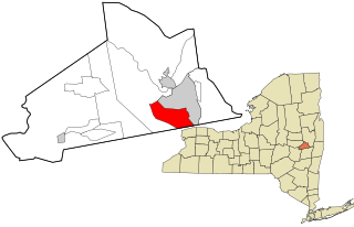
Rotterdam is a census-designated place (CDP) in the town of Rotterdam in Schenectady County, New York, United States. It is a suburb of Schenectady. The population was 20,652 at the 2010 census.

<span class="mw-page-title-main">Brandon (CDP), Vermont</span> CDP in Vermont, United States

Brandon is an unincorporated village and census-designated place (CDP) in the town of Brandon, Rutland County, Vermont, United States. As of the 2020 census, the population was 1,727.

<span class="mw-page-title-main">Jefferson Valley, New York</span> Census-designated place in New York, United States

Jefferson Valley-Yorktown, commonly known as Jefferson Valley, is a census-designated place (CDP) located in the town of Yorktown in Westchester County, New York, United States. The population was 14,142 at the 2010 census. It is a hot spot for local shoppers, due to its Jefferson Valley Mall.

References

  1. "ArcGIS REST Services Directory". United States Census Bureau. Retrieved September 20, 2022.
  2. 1 2 "U.S. Census website". United States Census Bureau . Retrieved January 31, 2008.
  3. "US Board on Geographic Names". United States Geological Survey. October 25, 2007. Retrieved January 31, 2008.
  4. "Profile of General Population and Housing Characteristics: 2010 Demographic Profile Data (DP-1): Yorktown Heights CDP, New York". United States Census Bureau . Retrieved November 22, 2011.
  5. "National Register Information System". National Register of Historic Places . National Park Service. March 13, 2009.
  6. "US Gazetteer files: 2010, 2000, and 1990". United States Census Bureau. February 12, 2011. Retrieved April 23, 2011.
  7. "Geographic Identifiers: 2010 Demographic Profile Data (G001): Yorktown Heights CDP, New York". United States Census Bureau . Retrieved November 22, 2011.
  8. "Summary of Monthly Normals 1991-2020" . Retrieved May 12, 2022.
  9. "Census of Population and Housing". Census.gov. Retrieved June 4, 2016.
  10. Daily Voice (April 18, 2017). "Happy Birthday To Yorktown's Robert Hanssen | Yorktown Daily Voice". Dailyvoice.com. Retrieved August 3, 2022.
  11. "Alexandria Ocasio-Cortez Emerges as a Political Star". The New York Times . Retrieved July 2, 2018.
  12. "American Girl and Costa Rican President Wed". Sarasota Herald-Tribune . February 8, 1954.