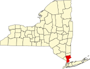
Crugers, New York

Last updated
Crugers, New York
CDP
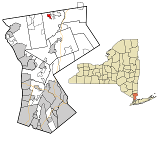
Westchester County New York incorporated and unincorporated areas Crugers highlighted.svg
Location of Crugers, New York
Coordinates: 41°13′59″N73°55′18″W / 41.23306°N 73.92167°W / 41.23306; -73.92167
Country United States
State New York
County Westchester
Town Cortlandt
Area
[1]
  Total1.23 sq mi (3.20 km2)
  Land0.66 sq mi (1.72 km2)
  Water0.57 sq mi (1.48 km2)
Elevation
95 ft (29 m)
Population
 (2020)
  Total1,627
  Density2,450.30/sq mi (945.93/km2)
Time zone UTC−5 (Eastern (EST))
  Summer (DST) UTC−4 (EDT)
ZIP Code
10521
Area code 914
FIPS code 36-19290
GNIS feature ID0947860

Crugers is a hamlet and census-designated place (CDP) located in the town of Cortlandt, Westchester County, New York, United States. The population was 1,534 at the 2010 census. [2]

Contents

History

Crugers, New York, was named for Col. John P. Cruger. [3]

The community formerly had two New York Central Railroad stations along the Hudson Line; one was Oscawana Station in Oscawana Park, and the other was named for the community at the northwestern end of Crugers Avenue across the tracks from the VA Hudson Valley Health Care System.

Geography

Crugers is located at 41°13′59″N73°55′18″W / 41.23306°N 73.92167°W / 41.23306; -73.92167 (41.232981, -73.921586). [4]

According to the United States Census Bureau, the hamlet has a total area of 1.3 square miles (3.4 km2), of which 0.7 square miles (1.8 km2) is land and 0.6 square miles (1.6 km2), or 44.44%, is water.

Demographics

Historical population
CensusPop.Note
2020 1,627
U.S. Decennial Census [5]

As of the census [6] of 2000, there were 1,752 people, 826 households, and 327 families residing in the hamlet. The population density was 2,506.4 inhabitants per square mile (967.7/km2). There were 846 housing units at an average density of 1,210.3 per square mile (467.3/km2). The racial makeup of the hamlet was 92.18% White, 4.05% African American, 0.51% Native American, 0.97% Asian, 1.14% from other races, and 1.14% from two or more races. Hispanic or Latino of any race were 3.54% of the population.

There were 826 households, out of which 13.7% had children under the age of 18 living with them, 33.8% were married couples living together, 5.2% had a female householder with no husband present, and 60.3% were non-families. 59.0% of all households were made up of individuals, and 44.6% had someone living alone who was 65 years of age or older. The average household size was 1.79 and the average family size was 2.90.

In the hamlet the population was spread out, with 12.8% under the age of 18, 2.5% from 18 to 24, 16.0% from 25 to 44, 21.9% from 45 to 64, and 46.8% who were 65 years of age or older. The median age was 63 years. For every 100 females, there were 70.9 males. For every 100 females age 18 and over, there were 66.3 males.

The median income for a household in the hamlet was $30,375, and the median income for a family was $86,598. Males had a median income of $58,571 versus $55,081 for females. The per capita income for the hamlet was $29,643. About 4.5% of families and 5.6% of the population were below the poverty line, including none of those under age 18 and 9.9% of those age 65 or over.

See also

Related Research Articles

<span class="mw-page-title-main">Pelican Bay, Florida</span> Census-designated place in Florida

Pelican Bay is a census-designated place (CDP) in Collier County, Florida, United States. The population was 6,346 at the 2010 census. It is part of the Naples–Marco Island Metropolitan Statistical Area.

<span class="mw-page-title-main">Chubbuck, Idaho</span> City in Idaho, United States

Chubbuck is a city in Bannock County, Idaho. It is part of the Pocatello Metropolitan Statistical Area. The population was 13,922 at the 2010 census. Chubbuck is located immediately north of Pocatello, Idaho, and has opposed several consolidation proposals since the 1960s.

<span class="mw-page-title-main">Sloan, Iowa</span> City in Iowa, United States

Sloan is a city in Woodbury County, Iowa, United States. It is part of the Sioux City, IA–NE–SD Metropolitan Statistical Area. The population was 1,042 at the time of the 2020 census.

<span class="mw-page-title-main">Cruger, Mississippi</span> Town in Mississippi, United States

Cruger is a town in Holmes County, Mississippi, United States. Per the 2020 census, the population was 268.

Stottville is a hamlet and census-designated place (CDP) in Columbia County, New York, United States. The population was 1,375 at the 2010 census.

<span class="mw-page-title-main">Brinckerhoff, New York</span> Census-designated place in New York, United States

Brinckerhoff is a hamlet and census-designated place (CDP) in Dutchess County, New York, United States. The population was 2,900 at the 2010 census. It is part of the Poughkeepsie–Newburgh–Middletown, NY Metropolitan Statistical Area as well as the larger New York–Newark–Bridgeport, NY-NJ-CT-PA Combined Statistical Area.

<span class="mw-page-title-main">Crown Heights, New York</span> Census-designated place in New York, United States

Crown Heights is a hamlet and census-designated place (CDP) in Dutchess County, New York, United States. The population was 2,840 at the 2010 census. It is part of the Poughkeepsie–Newburgh–Middletown, NY Metropolitan Statistical Area as well as the larger New York–Newark–Bridgeport, NY-NJ-CT-PA Combined Statistical Area.
<span class="mw-page-title-main">Red Oaks Mill, New York</span> Census-designated place in New York, United States

Red Oaks Mill is a hamlet and census-designated place (CDP) in Dutchess County, in the U.S. state of New York. It lies within the limits of the towns of Poughkeepsie and LaGrange. The population was 3,613 at the 2010 census.

<span class="mw-page-title-main">Jewett, New York</span> Town in New York, United States

Jewett is a town centrally located in Greene County, New York, United States. The population was 953 at the 2010 census. The town is named for Freeborn G. Jewett, justice of the New York Supreme Court.
<span class="mw-page-title-main">Carmel Hamlet, New York</span> Hamlet and Census-designated place in New York, United States

Carmel Hamlet, commonly known simply as Carmel, is a hamlet and census-designated place (CDP) located in the Town of Carmel in Putnam County, New York, United States. As of the 2010 census, the population was 6,817.

<span class="mw-page-title-main">Lake Carmel, New York</span> Census-designated place in New York, United States

Lake Carmel is a hamlet and census-designated place in the town of Kent in Putnam County, New York, United States. The home of over half of the town of Kent's population of 8,282, the hamlet is centered around Lake Carmel, a 1.6 mile long manmade lake in the southeastern corner of the township and just north of hamlet of Carmel within the town of Carmel.
<span class="mw-page-title-main">Lake Katrine, New York</span> CDP in New York, United States

Lake Katrine is a hamlet in Ulster County, New York, United States. The population was 2,522 at the 2020 census.

<span class="mw-page-title-main">Cortlandt, New York</span> Town in New York, United States

Cortlandt is a town in Westchester County, New York, United States, located at the northwestern edge of the county, at the eastern terminus of the Bear Mountain Bridge. The town includes the villages of Buchanan and Croton-on-Hudson.

<span class="mw-page-title-main">Crompond, New York</span> CDP in New York, United States

Crompond is a hamlet and census-designated place (CDP) located in the town of Yorktown in Westchester County, New York, United States. The population was 2,292 at the 2010 census.

<span class="mw-page-title-main">Lincolndale, New York</span> Census-designated place in New York, United States

Lincolndale is a hamlet and census-designated place (CDP) located in the town of Somers in Westchester County, New York, United States. The population was 1,521 at the 2010 census.
<span class="mw-page-title-main">Shenorock, New York</span> CDP in New York, United States

Shenorock is a hamlet and census-designated place (CDP) located in the town of Somers in Westchester County, New York, United States. The population was 1,898 at the 2010 census.

<span class="mw-page-title-main">Shrub Oak, New York</span> CDP in New York, United States

Shrub Oak is an unincorporated hamlet and census-designated place (CDP) located in the town of Yorktown in Westchester County, New York, United States. The population was 2,011 at the 2010 census.

<span class="mw-page-title-main">Jourdanton, Texas</span> City in Texas, United States

Jourdanton is a city in and the county seat of Atascosa County, Texas, United States. The population is 4,094. It is part of the San Antonio metropolitan statistical area. The mayor is Robert "Doc" Williams. The city manager is Bobby J. Martinez. The police chief is Eric Kaiser. The fire chief is Jay Fojtik.

<span class="mw-page-title-main">Amenia (CDP), New York</span> Hamlet in the state of New York, United States

Amenia is a hamlet and census-designated place (CDP) in Dutchess County, New York, United States. The population was 955 at the 2010 census. It is part of the Poughkeepsie–Newburgh–Middletown, NY Metropolitan Statistical Area as well as the larger New York–Newark–Bridgeport, NY-NJ-CT-PA Combined Statistical Area.

<span class="mw-page-title-main">Jefferson Valley, New York</span> Census-designated place in New York, United States

Jefferson Valley-Yorktown, commonly known as Jefferson Valley, is a census-designated place (CDP) located in the town of Yorktown in Westchester County, New York, United States. The population was 14,142 at the 2010 census. It is a hot spot for local shoppers, due to its Jefferson Valley Mall.

References

  1. "ArcGIS REST Services Directory". United States Census Bureau. Retrieved September 20, 2022.
  2. "Profile of General Population and Housing Characteristics: 2010 Demographic Profile Data (DP-1): Crugers CDP, New York". United States Census Bureau . Retrieved November 21, 2011.
  3. Gannett, Henry (1905). The Origin of Certain Place Names in the United States. Govt. Print. Off. p.  96.
  4. "US Gazetteer files: 2010, 2000, and 1990". United States Census Bureau. 2011-02-12. Retrieved 2011-04-23.
  5. "Census of Population and Housing". Census.gov. Retrieved June 4, 2016.
  6. "U.S. Census website". United States Census Bureau . Retrieved 2008-01-31.