Heritage Hills, New York

Last updated

Heritage Hills, New York
Heritage Hills, NY Seal.png
Heritage Hills, NY Logo.png
Westchester County New York incorporated and unincorporated areas Heritage Hills highlighted.svg
Location of Heritage Hills, New York
Coordinates: 41°20′18″N73°41′50″W / 41.33833°N 73.69722°W / 41.33833; -73.69722
Country United States
State New York
County Westchester
Town Somers
Area
[1]
  Total1.90 sq mi (4.93 km2)
  Land1.88 sq mi (4.86 km2)
  Water0.03 sq mi (0.07 km2)
Elevation
587 ft (179 m)
Population
 (2020)
  Total4,511
  Density2,404.58/sq mi (928.44/km2)
Time zone UTC-5 (Eastern (EST))
  Summer (DST) UTC-4 (EDT)
FIPS code 36-34118
GNIS feature ID1852901
Website heritagehills.com

Heritage Hills is a hamlet (and census-designated place) within the town of Somers in Westchester County, New York. The population was 3,975 at the 2010 census. [2]

Contents

Geography

Heritage Hills is located at 41°20′18″N73°41′50″W / 41.338374°N 73.697321°W / 41.338374; -73.697321 . [3]

According to the United States Census Bureau, the CDP has a total area of 1.9 square miles (4.9 km2), of which 1.9 square miles (4.8 km2) is land and 0.039 square miles (0.1 km2), or 2.03%, is water. [2]

Demographics

Historical population
CensusPop.Note
2020 4,511
U.S. Decennial Census [4]

As of the census [5] of 2000, there were 3,683 people, 2,119 households, and 1,146 families residing in the CDP. The population density was 1,591.0 inhabitants per square mile (614.3/km2). There were 2,290 housing units at an average density of 989.2 per square mile (381.9/km2). The racial makeup of the CDP was 96.99% White, 0.87% African American, 0.03% Native American, 1.47% Asian, 0.08% from other races, and 0.57% from two or more races. Hispanic or Latino of any race were 1.09% of the population.

There were 2,119 households, out of which 5.1% had children under the age of 18 living with them, 49.6% were married couples living together, 3.6% had a female householder with no husband present, and 45.9% were non-families. 43.0% of all households were made up of individuals, and 30.0% had someone living alone who was 65 years of age or older. The average household size was 1.72 and the average family size was 2.25.

In the CDP, the population was spread out, with 5.3% under the age of 18, 1.3% from 18 to 24, 11.7% from 25 to 44, 27.1% from 45 to 64, and 54.7% who were 65 years of age or older. The median age was 67 years. For every 100 females, there were 69.0 males. For every 100 females age 18 and over, there were 67.9 males.

The median income for a household in the CDP was $63,450, and the median income for a family was $90,904. Males had a median income of $89,866 versus $48,598 for females. The per capita income for the CDP was $46,523. About 0.6% of families and 3.3% of the population were below the poverty line, including none of those under age 18 and 2.5% of those age 65 or over.

Originally, at least one member of each household had to be at least 40 years old, with no one under 18 allowed to live in the development.[ citation needed ]

Related Research Articles

<span class="mw-page-title-main">Blue Ridge, Alabama</span> Census-designated place in Alabama, United States

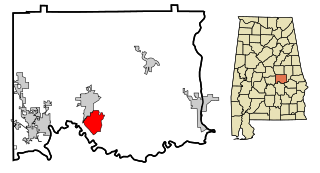
Blue Ridge is an unincorporated community and census-designated place (CDP) in Elmore County, Alabama, United States. At the 2020 census, the population was 1,485. It is part of the Montgomery Metropolitan Statistical Area.

<span class="mw-page-title-main">Derby Acres, California</span> Census-designated place in California, United States

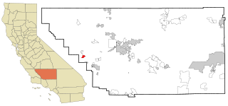
Derby Acres is a census-designated place (CDP) in Kern County, California, United States. Derby Acres is located 5.5 miles (8.9 km) north-northwest of Fellows, at an elevation of 1,375 feet (419 m). The population was 322 at the 2010 census, down from 376 at the 2000 census. The town is on State Route 33 at the northern extremity of the Midway-Sunset Oil Field, about five miles (8 km)five miles southeast of McKittrick.

<span class="mw-page-title-main">Parkwood, California</span> Census-designated place in California, United States

Parkwood is a census-designated place (CDP) in Madera County, California, United States. It is part of the Madera Metropolitan Statistical Area. The population was 2,307 at the 2020 census.

<span class="mw-page-title-main">East Harwich, Massachusetts</span> Census-designated place in Massachusetts, United States

East Harwich is a census-designated place (CDP) and village in the town of Harwich in Barnstable County, Massachusetts, United States. The population was 4,872 at the 2010 census.

<span class="mw-page-title-main">Brinckerhoff, New York</span> Census-designated place in New York, United States

Brinckerhoff is a hamlet and census-designated place (CDP) in Dutchess County, New York, United States. The population was 2,900 at the 2010 census. It is part of the Poughkeepsie–Newburgh–Middletown, NY Metropolitan Statistical Area as well as the larger New York–Newark–Bridgeport, NY-NJ-CT-PA Combined Statistical Area.

<span class="mw-page-title-main">Crown Heights, New York</span> Census-designated place in New York, United States

Crown Heights is a hamlet and census-designated place (CDP) in Dutchess County, New York, United States. The population was 2,840 at the 2010 census. It is part of the Poughkeepsie–Newburgh–Middletown, NY Metropolitan Statistical Area as well as the larger New York–Newark–Bridgeport, NY-NJ-CT-PA Combined Statistical Area.

<span class="mw-page-title-main">Myers Corner, New York</span> Census-designated place in New York, United States

Myers Corner is a hamlet and census-designated place (CDP) in the town of Wappinger, Dutchess County, New York, United States. The population was 6,790 at the 2010 census. It is part of the Poughkeepsie–Newburgh–Middletown, NY Metropolitan Statistical Area as well as the larger New York–Newark–Bridgeport, NY-NJ-CT-PA Combined Statistical Area.

<span class="mw-page-title-main">Brewster Hill, New York</span> Census-designated place in New York, United States

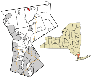
Brewster Hill is a hamlet located in the town of Southeast in Putnam County, New York, United States. As of the 2010 census, the population was 2,089.

<span class="mw-page-title-main">Carmel Hamlet, New York</span> Hamlet and Census-designated place in New York, United States

Carmel Hamlet, commonly known simply as Carmel, is a hamlet and census-designated place (CDP) located in the Town of Carmel in Putnam County, New York, United States. As of the 2010 census, the population was 6,817.

<span class="mw-page-title-main">Crompond, New York</span> CDP in New York, United States

Crompond is a hamlet and census-designated place (CDP) located in the town of Yorktown in Westchester County, New York, United States. The population was 2,292 at the 2010 census.

<span class="mw-page-title-main">Fairview, Westchester County, New York</span> CDP in New York, United States

Fairview is a hamlet and a census-designated place (CDP) located in the town of Greenburgh, Westchester County, New York, United States. The population was 3,099 at the 2010 census. As of 2000, Fairview had the fourth-highest percentage of African-Americans in New York.

<span class="mw-page-title-main">Goldens Bridge, New York</span> Census-designated place in New York, United States

Goldens Bridge is a hamlet and census-designated place (CDP) in the town of Lewisboro in Westchester County, New York, United States. The population was 1,630 at the 2010 census.

<span class="mw-page-title-main">Lincolndale, New York</span> Census-designated place in New York, United States

Lincolndale is a hamlet and census-designated place (CDP) located in the town of Somers in Westchester County, New York, United States. The population was 1,521 at the 2010 census.

<span class="mw-page-title-main">Shenorock, New York</span> CDP in New York, United States

Shenorock is a hamlet and census-designated place (CDP) located in the town of Somers in Westchester County, New York, United States. The population was 1,898 at the 2010 census.

<span class="mw-page-title-main">Sandy, Pennsylvania</span> Census-designated place in Pennsylvania, United States

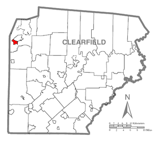
Sandy is a census-designated place (CDP) in Clearfield County, Pennsylvania, United States. The population was 1,362 at the 2020 census.

<span class="mw-page-title-main">East Hill-Meridian, Washington</span> Former CDP in Washington, United States

East Hill-Meridian is a former census-designated place (CDP) in King County, Washington. The population was 29,878 at the time of the 2010 census. The majority of the census area is now within the limits of Kent and Renton.

<span class="mw-page-title-main">Pine Plains (CDP), New York</span> Census-designated place in New York, United States

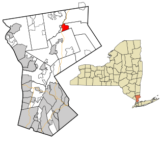
Pine Plains is a hamlet and census-designated place (CDP) in Dutchess County, New York, United States. The population was 1,142 at the 2020 census. It is part of the Poughkeepsie–Newburgh–Middletown, NY Metropolitan Statistical Area as well as the larger New York–Newark–Bridgeport, NY-NJ-CT-PA Combined Statistical Area.

<span class="mw-page-title-main">Pleasant Valley (CDP), New York</span> Census-designated place in New York, United States

Pleasant Valley is a census-designated place (CDP) in the southwestern part of the town of Pleasant Valley in Dutchess County, New York, United States. The population was 1,145 at the 2010 census. It is part of the Poughkeepsie–Newburgh–Middletown, NY Metropolitan Statistical Area as well as the larger New York–Newark–Bridgeport, NY-NJ-CT-PA Combined Statistical Area.

<span class="mw-page-title-main">Jefferson Valley, New York</span> Census-designated place in New York, United States

Jefferson Valley-Yorktown, commonly known as Jefferson Valley, is a census-designated place (CDP) located in the town of Yorktown in Westchester County, New York, United States. The population was 14,142 at the 2010 census. It is a hot spot for local shoppers, due to its Jefferson Valley Mall.

Madison is a census-designated place (CDP) in the town of Madison in Somerset County, Maine, United States. The population was 2,533 at the 2020 census.

References

  1. "ArcGIS REST Services Directory". United States Census Bureau. Retrieved September 20, 2022.
  2. 1 2 "Geographic Identifiers: 2010 Demographic Profile Data (G001): Heritage Hills CDP, New York". U.S. Census Bureau, American Factfinder. Archived from the original on February 12, 2020. Retrieved January 30, 2013.
  3. "US Gazetteer files: 2010, 2000, and 1990". United States Census Bureau. February 12, 2011. Retrieved April 23, 2011.
  4. "Census of Population and Housing". Census.gov. Retrieved June 4, 2016.
  5. "U.S. Census website". United States Census Bureau . Retrieved January 31, 2008.