Croton-on-Hudson, New York | |
---|---|
Village of Croton-on-Hudson | |
Coordinates: 41°12′15″N73°53′10″W / 41.20417°N 73.88611°W | |
Country | United States |
State | New York |
County | Westchester |
Town | Cortlandt |
Government | |
• Mayor | Brian Pugh (D) |
Area | |
• Total | 10.75 sq mi (27.85 km2) |
• Land | 4.69 sq mi (12.16 km2) |
• Water | 6.06 sq mi (15.70 km2) |
Elevation | 164 ft (50 m) |
Population (2020) | |
• Total | 8,327 |
• Density | 1,774.34/sq mi (685.03/km2) |
• Demonym | Crotonite |
Time zone | UTC-5 (Eastern (EST)) |
• Summer (DST) | UTC-4 (EDT) |
ZIP codes | 10520-10521 |
Area code | 914 |
FIPS code | 36-19213 |
GNIS feature ID | 0947832 |
Website | www.crotononhudson-ny.gov |
Croton-on-Hudson is a village in Westchester County, New York, United States. The population was 8,327 at the 2020 United States census over 8,070 at the 2010 census. [2] It is located in the town of Cortlandt as part of New York City's northern suburbs. The village was incorporated in 1898.
People lived from at latest about 7000 BC [3] in what would become the village. [4] The Kitchawanc tribe, part of the Wappinger Confederacy of the Algonquian peoples, signed a peace treaty with the newly arriving Dutch people at Croton Point in 1645, now commemorated by a plaque in the park there.
Stephanus van Cortlandt began acquiring land in the area in 1677 (the year he became mayor of New York City) to create a manor. It was granted by royal patent in 1697 as the Manor of Cortlandt, including the area known as Croton Landing where the Croton River meets the Hudson River, where the manor house was built. A 1718 census reports 91 inhabitants including Dutch settlers and English Quakers. People worked the manor primarily as farmers or millers.
In the mid- to late 1800s first the Croton Dam, then the New Croton Dam, and the Croton Aqueduct were built on the Croton River to supply New York City, along with the New York Central Railroad station on the Hudson River. Many Irish, Italian and German immigrants moved to the area to work on those projects, increasing the population dramatically. By 1898, when the Village incorporated, the population was 1,000 people, growing to 1,700 people in the early 1900s.
In 1846 work began on a Hudson River rail line from Poughkeepsie to New York City. Clifford Harmon, a realtor, purchased 550 acres of land next to the village of Croton in 1903. He gave part of the land to the New York Central Railroad to build a train station, on the condition that the station would forever be named after him. Today it is called the Croton-Harmon station of the Metro-North Railroad and of Amtrak. [5] In 1906, the station became a major service facility for the railroad. The station expanded even further in 1913, when it became the stop at which electric trains from New York City switched to steam engines. [6] The station still serves this purpose, but for diesel locomotives instead of steam engines.
Harmon thrived as an artist's colony alongside the village, while the neighboring Mount Airy community evolved from Quakers to Greenwich Village artists and writers by the early 1900s. Mount Airy was home to many early members of the American Communist Party. [7] In 1932 Harmon and most of Mount Airy were incorporated into the village.
Croton-on-Hudson is located at 41°12′15″N73°53′10″W / 41.20417°N 73.88611°W (41.204228, -73.886177) [8] on the shores of the Hudson River. The zip codes are 10520 and 10521.
According to the United States Census Bureau, the village has a total area of 10.8 square miles (28.0 km2), of which 4.8 square miles (12.4 km2) is land and 6.1 square miles (15.8 km2), or 56.06%, is water.
Census | Pop. | Note | %± |
---|---|---|---|
1900 | 1,533 | — | |
1910 | 1,806 | 17.8% | |
1920 | 2,286 | 26.6% | |
1930 | 2,447 | 7.0% | |
1940 | 3,843 | 57.0% | |
1950 | 4,837 | 25.9% | |
1960 | 6,812 | 40.8% | |
1970 | 7,523 | 10.4% | |
1980 | 6,889 | −8.4% | |
1990 | 7,018 | 1.9% | |
2000 | 7,606 | 8.4% | |
2010 | 8,070 | 6.1% | |
2020 | 8,327 | 3.2% | |
U.S. Decennial Census [9] |
As of the census [10] of 2000, there were 7,606 people, 2,798 households, and 2,050 families residing in the village. The population density was 1,601.7 inhabitants per square mile (618.4/km2). There were 2,859 housing units at an average density of 602.1 per square mile (232.5/km2). The racial makeup of the village was 91.5% white, 1.9% African American, 0.26% Native American, 2.06% Asian, 0.01% Pacific Islander, 2.58% from other races, and 1.70% from two or more races. Hispanic or Latino of any race were 6.93% of the population.
There were 2,798 households, out of which 38.7% had children under the age of 18 living with them, 62.5% were married couples living together, 8.2% had a female householder with no husband present, and 26.7% were non-families. 22.2% of all households were made up of individuals, and 7.7% had someone living alone who was 65 years of age or older. The average household size was 2.65 and the average family size was 3.11.
In the village, the population was spread out, with 25.7% under the age of 18, 4.5% from 18 to 24, 30.1% from 25 to 44, 26.1% from 45 to 64, and 13.6% who were 65 years of age or older. The median age was 40 years. For every 100 females, there were 90.8 males. For every 100 females age 18 and over, there were 86.7 males.
The median income for a household in the village was $150,260, and the median income for a family was $250,000+.
As of the regular 2017 elections [11]
Croton-on-Hudson's economy has historically thrived on the Metro North train station that up until the early 1980s served as the point at which northbound trains would exchange their electric engines for other modes of conveyance. [12] [13] During those days, the train station and its super-adjacent area was known as Harmon. Because maintenance of diesel and steam engines was then very labor-intensive, there were many workers whose needs were served by abundant service businesses, such as restaurants and bars. Because of the separate development of both the Harmon and the Mt. Airy communities, there were originally two commercial districts—one centered on Grand Street, and the other in Harmon—though in recent years the two have merged into a single sprawling commercial district. There is also a North Riverside commercial district serving communities along Riverside Drive, Brook Street, Grand Street, and Bank Street.
After the New York Central Railroad folded into Penn Central in 1968, Croton-on-Hudson's economy slowly stagnated. Although Croton-Harmon station still served as the main transfer point northbound between local and express trains, the laborers who had earlier fueled a bustling service economy were no longer present in Harmon. The exodus of labor during the early 1970s was compounded by the stagflation that was a result of higher oil prices and skyrocketing interest rates.
There has been an ongoing effort since the early 1990s to develop the riverfront for recreational use. Among the accomplishments are a pedestrian bridge spanning U.S. Route 9 and NY 9A between the lower village and Senasqua Park, the Crossining pedestrian footbridge across the Croton River, the bicycle trail extensions around Half Moon Bay Condominiums, rehabilitation of the "Picture Tunnel" (repaving and closing it to cars), and acquisition and clearing of the Croton Landing property. In addition, Croton Point Park is also along the riverfront. [14]
The town is a stop for Amtrak's Empire Service , Adirondack , Maple Leaf , Ethan Allen Express , and Lake Shore Limited routes, as well the MTA's Metro-North Hudson Line service, both at the Croton-Harmon station. Metro-North's main shops and yards are also located here.
Croton Point Park hosts Clearwater's Great Hudson River Revival, a yearly folk music, art and environmental festival.
Croton-on-Hudson has an annual event called the Summerfest. Every year the central business district (with corners at the municipal building, Grand Street fire house and Croton-Harmon High School) is closed to automobile traffic for music, American food, local fund raisers, traveling, and local artists. [ citation needed ]
Since 1981 Croton-on-Hudson has been the home of the annual Harry Chapin Run Against Hunger, a 10k race and Fun Run, held on a Sunday afternoon in October. [15] [16]
Every weekend in October, people visit Van Cortlandt Manor to see the Blaze. Started in 2005, the Blaze consists of thousands of pumpkins which are hollowed out by volunteers but carved by a creative team. [17]
The Asbury United Methodist Church and Bethel Chapel and Cemetery, Croton North Railroad Station, and St. Augustine's Episcopal Church Complex are listed on the National Register of Historic Places. Van Cortlandt Manor is listed as a National Historic Landmark. [18]
From the 1910s to the 1960s, Croton was a popular location for the summer homes of American communists, socialists and other radicals and many important artists and writers. This gave the Mt. Airy area in Croton the nickname "Red Hill" [19]
Croton-on-Hudson is the original home of the Hudson Institute, a key Cold War think tank where the "Mutual Assured Destruction" strategy for nuclear war deterrence was developed.
The village is home to one of a handful operating "dummy lights" in the United States, located downtown at the intersection of Old Post Road South and Grand Street. It is a traffic signal on a pedestal which sits in the middle of an intersection, dating back to the 1920s. Another active dummy light located in New York State is at Beacon. [20] The one in Canajoharie was removed in 2021. [21] [22] [23]
Parks and sites of interest in the community include:
This section needs additional citations for verification .(April 2008) |
Films shot in Croton-on-Hudson include: [42]
Westchester County is located in the U.S. state of New York. It is the seventh most populous county in the State of New York and the most populous north of New York City. According to the 2020 United States Census, the county had a population of 1,004,456, its highest decennial count ever and an increase of 55,344 (5.8%) from the 949,113 counted in 2010. Westchester covers an area of 450 square miles (1,200 km2), consisting of six cities, 19 towns, and 23 villages. Established in 1683, Westchester was named after the city of Chester, England. The county seat is the city of White Plains, while the most populous municipality in the county is the city of Yonkers, with 211,569 residents per the 2020 census. The county is part of the Hudson Valley region of the state.
Briarcliff Manor is a suburban village in Westchester County, New York, 30 miles (50 km) north of New York City. It is on 5.9 square miles (15 km2) of land on the east bank of the Hudson River, geographically shared by the towns of Mount Pleasant and Ossining. Briarcliff Manor includes the communities of Scarborough and Chilmark, and is served by the Scarborough station of the Metro-North Railroad's Hudson Line. A section of the village, including buildings and homes covering 376 acres (152 ha), is part of the Scarborough Historic District and was listed on the National Register of Historic Places in 1984. The village motto is "A village between two rivers", reflecting Briarcliff Manor's location between the Hudson and Pocantico Rivers. Although the Pocantico is the primary boundary between Mount Pleasant and Ossining, since its incorporation the village has spread into Mount Pleasant.
Cortlandt is a town in Westchester County, New York, United States, located at the northwestern edge of the county, at the eastern terminus of the Bear Mountain Bridge. The town includes the villages of Buchanan and Croton-on-Hudson.
Yorktown is a town on the northern border of Westchester County, New York, United States. A suburb of the New York City metropolitan area, it is approximately 38 miles (61 km) north of midtown Manhattan. The population was 36,569 at the 2020 U.S. Census.
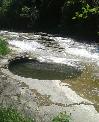
Canajoharie is a village in the Town of Canajoharie in Montgomery County, New York, United States. As of the 2010 census, the village had a population of 2,229. The name is said to be a Mohawk language term meaning "the pot that washes itself," referring to the "Canajoharie Boiling Pot," a circular gorge in the Canajoharie Creek, just south of the village.
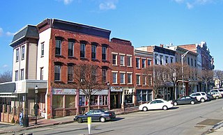
Ossining is a village in Westchester County, New York, United States. The population at the 2020 United States census was 27,551, an increase from 25,060 at the 2010 census. As a village, it is located in the town of Ossining.
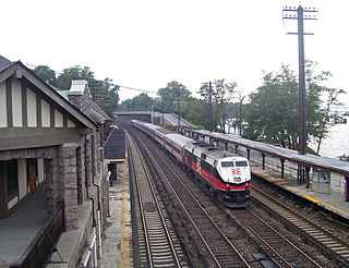
Philipse Manor station is a commuter rail stop on the Metro-North Railroad's Hudson Line, located in the Philipse Manor area of Sleepy Hollow, New York, United States.
Pierre Van Cortlandt was an American politician who served as the first lieutenant governor of New York.
The New York and Putnam Railroad, nicknamed the Old Put, was a railroad line that operated between the Bronx and Brewster in New York State. It was in close proximity to the Hudson River Railroad and New York and Harlem Railroad. All three came under ownership of the New York Central system in 1894. The railroad was abandoned starting in 1958, and most of the former roadbed has been converted to rail trail use.
Cortlandt Manor is a hamlet—an unincorporated section—of the town of Cortlandt in northern Westchester County, New York, roughly surrounding Peekskill, encompassing Corlandt Estates and lying east of three sections of the town of Cortlandt, Croton-on-Hudson, Crugers, and Montrose. It is a mostly residential area.
Montrose is a hamlet within the town of Cortlandt, in the northwestern corner of Westchester County, New York, United States. It is located near Croton-on-Hudson and Buchanan. The rural character of the hamlet is defined by the Hudson River, numerous wooded hills and steep slopes, wetland areas and beautiful streams. As of the 2010 census, Montrose had a population of 2,731.
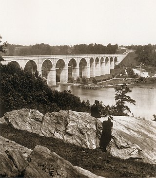
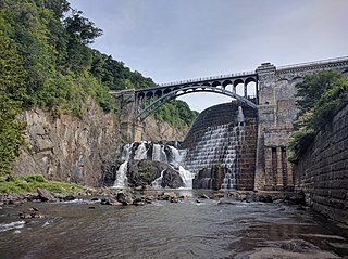
The Croton Aqueduct or Old Croton Aqueduct was a large and complex water distribution system constructed for New York City between 1837 and 1842. The great aqueducts, which were among the first in the United States, carried water by gravity 41 miles (66 km) from the Croton River in Westchester County to reservoirs in Manhattan. It was built because local water resources had become polluted and inadequate for the growing population of the city. Although the aqueduct was largely superseded by the New Croton Aqueduct, which was built in 1890, the Old Croton Aqueduct remained in service until 1955.
The Hudson Line is a commuter rail line owned and operated by the Metro-North Railroad in the U.S. state of New York. It runs north from New York City along the east shore of the Hudson River, terminating at Poughkeepsie. The line was originally the Hudson River Railroad, and eventually became the Hudson Division of the New York Central Railroad. It runs along what was the far southern leg of the Central's famed "Water Level Route" to Chicago.
Often referred to as Mt. Airy, this neighborhood is situated immediately south of Furnace Woods and north of Croton, and is partially situated in both unincorporated Cortlandt and the village of Croton-on-Hudson in Westchester County, New York, United States.
New York State Route 129 (NY 129) is a 7.75-mile (12.47 km) long state highway in the western part of Westchester County, New York. The route begins at New York State Route 9A in the village of Croton on Hudson at the Hudson River. NY 129 then travels through the towns of Cortlandt and Yorktown, running along the northern edge of the New Croton Reservoir. It passes under (southbound) and over (northbound) the Taconic State Parkway in Yorktown with no direct interchange. NY 129 ends in Yorktown at an intersection with NY 118.
Pierre Van Cortlandt Jr. was a United States representative from New York. A member of New York's Van Cortlandt family, he was the son of Pierre Van Cortlandt, an early New York political figure, and brother of Philip Van Cortlandt, who was also a U.S. Representative from New York.
Van Cortlandt Manor is a 17th-century house and property built by the Van Cortlandt family located near the confluence of the Croton and Hudson Rivers in the village of Croton-on-Hudson in Westchester County, New York, United States. The colonial era stone and brick manor house is now a museum and is a National Historic Landmark.
Teatown Lake Reservation is a nonprofit nature preserve and environmental education center in Westchester County, New York, U.S., located in the towns of Ossining, Yorktown, Cortlandt, and New Castle. The reservation includes an 1,000-acre (4.0 km2) nature preserve and education center, visited annually by around 25,000 people.
Croton North station is a disused train station on Senasqua Road in Croton-on-Hudson, New York, United States. It was built by the New York Central Railroad in the late 19th century. In 1987 it was listed on the National Register of Historic Places as Croton North Railroad Station.
There are numerous nationally and locally designated historic sites and attractions in Westchester County. These include architecturally significant manors and estates, churches, cemeteries, farmhouses, African-American heritage sites, and underground railroad depots and waystations. There are sites from pre-Revolutionary and Revolutionary times, as well as battlegrounds. Westchester County also played an important role in the development of the modern suburb, and there are many associated heritage sites and museums.
{{cite web}}
: CS1 maint: bot: original URL status unknown (link), IBM Corporation.