
Madhya Pradesh is a state in central India. Its capital is Bhopal, and the largest city is Indore, with Jabalpur, Gwalior, Ujjain, Satna, Sagar and Rewa being the other major cities. Madhya Pradesh is the second largest Indian state by area and the fifth largest state by population with over 75 million residents. It borders the states of Uttar Pradesh to the northeast, Chhattisgarh to the southeast, Maharashtra to the south, Gujarat to the west, and Rajasthan to the northwest.
Bundelkhand is a geographical and cultural region and also a mountain range in central & North India. The hilly region is now divided between the states of Uttar Pradesh and Madhya Pradesh, with the larger portion lying in the latter state.

Madhya Bharat, also known as Malwa Union, was an Indian state in west-central India, created on 28 May 1948 from twenty-five princely states which until 1947 had been part of the Central India Agency, with Jiwajirao Scindia as its Rajpramukh.

Vindhya Pradesh was a former state of India. It occupied an area of 23,603 sq. miles. It was created in 1948 as Union of Baghelkhand and Bundelkhand States, shortly after Indian independence, from the territories of the princely states in the eastern portion of the former Central India Agency. It was named as Vindhya Pradesh on 25 January 1950 after the Vindhya Range, which runs through the centre of the province. The capital of the state was Rewa. It lay between Uttar Pradesh to the north and Madhya Pradesh to the south, and the enclave of Datia, which lay a short distance to the west, was surrounded by the state of Madhya Bharat.
Nimar is the southwestern region of Madhya Pradesh state in west-central India.This region also having sub-regions like nimad, khandya, bhuwana.

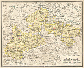
The Central India Agency was created in 1854, by amalgamating the Western Malwa Agency with other smaller political offices which formerly reported to the Governor-General of India. The agency was overseen by a political agent who maintained British relations with the princely states and influence over them on behalf of the Governor-General. The headquarters of the agent were at Indore.

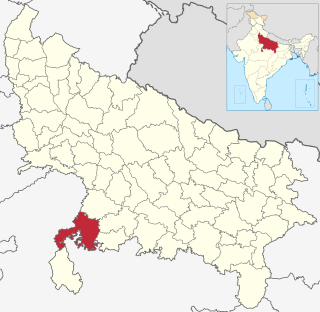
Datia is the district headquarters of the Datia District in north central Madhya Pradesh, a state of Central India. It is an ancient town, mentioned in the Mahabharata ruled by King Dantavakra. The city is 69 km from Gwalior, 325 km south of New Delhi and 320 km north of Bhopal. About 15 km from Datia is Sonagiri, a sacred Jain hill. Datia is also about 34 km from Jhansi and 52 km from Orchha. The nearest airport is at Gwalior. It was formerly the seat of the eponymous princely state in the British Raj. Datia is situated near Gwalior and on the border with Uttar Pradesh (U.P.).
Gird is a region of the Madhya Pradesh state in central India. It includes the districts of Bhind, Gwalior, Morena, Sheopur, and Shivpuri. Gwalior is the largest city in the region, and its historic center.

Datia District is in Gwalior Division in the Indian state of Madhya Pradesh. The town of Datia is its district headquarters.

Vidisha District (विदिशा) is in Madhya Pradesh state, in central India. The city of Vidisha is the administrative headquarters of the district.

Shivpuri District is a district of Madhya Pradesh state of India. The town of Shivpuri is the district headquarters. National Highway 3 (NH-3) runs through the district.

Gwalior district is one of the 52 districts of Madhya Pradesh state in central India. The historic city of Gwalior is its administrative headquarters. Other cities and towns in this district are Antari, Bhitarwar, Bilaua, Dabra, Morar Cantonment, Pichhore, and Tekanpur.
Jhansi district is one of the districts of Uttar Pradesh state in northern India. The city of Jhansi is the district headquarters. The district is bordered on the north by Jalaun District, to the east by Hamirpur and Mahoba districts, to the south by Tikamgarh District of Madhya Pradesh state, to the southwest by Lalitpur District, which is joined to Jhansi District by a narrow corridor, and on the east by the Datia and Bhind districts of Madhya Pradesh. Population 19,98,603. Lalitpur District, which extends into the hill country to the south, was added to Jhansi District in 1891, and made a separate district again in 1974.
Gwalior Residency was a political office in the British Indian Empire, which existed from 1782 until the British withdrawal from India in 1947.
The Datia train accident was a railroad accident that occurred on 3 October 2005 involving a passenger train near Datia in India's Madhya Pradesh Province. The accident occurred just three weeks before the Veligonda rail disaster which killed 114 people.
Isagarh District is a former administrative district (zila) of the princely state of Gwalior in central India. Gwalior state existed from the 18th century until shortly after Indian Independence in 1947. Geographically, the district included most of the present-day districts of Guna and Ashoknagar, along with a portion of northeastern Vidisha District. The administrative headquarters of the district was the town of Isagarh. The district was overseen by a subah, or district magistrate, who answered directly to the Sadr Board, the governing administrative body of the state.
Chanderi District was a former administrative district of British India. It covered most of present-day Lalitpur District of Uttar Pradesh state and the eastern portion of Ashoknagar District of Madhya Pradesh state.

Bhander is a town and a nagar panchayat in Datia district in the state of Madhya Pradesh.

Datia State was a princely state in subsidiary alliance with British India.

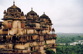
Datia Palace, also known as Bir Singh Palace or Bir Singh Dev Palace is situated nearly 75 km from Gwalior City in Madhya pradesh. The speciality of this palace is that it is of 7 floors. However, neither member from the royal family did ever live here. The founder of the Datia State in Bundelkhand - Maharaj Birsingh Deo Build many such 52 monuments all around the country. Datia's Palace or the Satkhanda Palace is also called Datia Mahal, as well as the Purana Mahal or the "Old Palace", Historian Abdul Hamid Lahori came to this city with Shah Jahan on 19 November 1635. He said that the palace was nearly 80 meters long and was also this much broad. He said this as a very beautiful and strong palace.
