Khandwa district

Last updated

Khandwa district
Narmada river Omkareshwar M.P India.jpg
0102621 Mamleshwar Temple, Amareshwar mandir, Omkareshwar Madhya Pradesh 201.jpg
Khandwa Railway Station (Central Railway) - panoramio - Camaal.jpg
Omkareshwar, Madhya Pradesh, India - panoramio (18).jpg
Kishore Kumar's house Gauri Kunj in Khandwa - panoramio - Camaal (3).jpg
Clockwise from top-left: Ghats of Mandhata, Mamleshwar temple, Omkareshwar Dam, Gauri Kunj, Khandwa railway station
MP Khandwa district map.svg
Location of Khandwa district in Madhya Pradesh
CountryFlag of India.svg  India
State Madhya Pradesh
Division Indore
Headquarters Khandwa
Tehsils Khandwa

Punasa

Mundi

Harsud

Pandhana
Government
   Lok Sabha constituencies Khandwa
   Vidhan Sabha constituencies Bagli (174)
Mandhata (175)
Harsud (176)
Khandwa (177)
Pandhana (178)
Area
  Total6,206 km2 (2,396 sq mi)
Population
 (2011)
  Total1,310,061
  Density210/km2 (550/sq mi)
Demographics
   Literacy 67.53 per cent
  Sex ratio944
Time zone UTC+05:30 (IST)
Major highways Khandwa-Indore State Highway
Khandwa-Mundi-Ashta State Highway
Khandwa-Amrawati Road
Website khandwa.nic.in

Khandwa district, formerly known as the East Nimar district, is a district of the Madhya Pradesh state in central India. The city of Khandwa is the administrative headquarters of the district. Other notable towns in the district include Mundi, Harsud, Pandhana and Omkareshwar.

Contents

Geography

The district has an area of 6,206 km2 (2,396 sq mi), and a population 1,310,061 (2011 census). Khandwa District lies in the Nimar region, which includes the lower valley of the Narmada River, Kherkhali River, Choti Tawa River, Shiva River. The Narmada forms part of the northern boundary of the district, and the Satpura Range form the southern boundary of the district. Burhanpur District, to the south, lies in the basin of the Tapti River. The pass through the Satpuras connecting Khandwa and Burhanpur is one of the main routes connecting northern and southern India, and the fortress of Asirgarh, which commands the pass, is known as the "Key to the Deccan". Betul and Harda districts lie to the east, Dewas District to the north, and Khargone District to the west.

History

Khandwa district was surrendered by the Marathas to the British Raj in 1818, and later became part of the Central Provinces and Berar. The area to the west, which forms the present Khargone district, was part of the princely state of Indore. After India's independence in 1947, the Central Provinces and Berar became the new Indian state of Madhya Pradesh.

The Khandwa district was known as "Nimar District" before 1956, when the state of Madhya Bharat to the west was merged with the state of Madhya Pradesh. Later it came to be called "East Nimar district", and a separate "West Nimar district" with headquarters at Khargone was established. The East Nimar district was part of the Nerbudda (Narmada) Division of the Central Provinces and Berar, which became the state of Madhya Bharat (later Madhya Pradesh) after India's independence in 1947. [1] Khandwa was known as East Nimar until recently. Burhanpur District was separated from Khandwa District on 15 August 2003. Khandwa District is part of Indore Division.

Economy

In 2006 the Ministry of Panchayati Raj named Khandwa one of the country's 250 most backward districts (out of a total of 640). [2] It is one of the 24 districts in Madhya Pradesh currently receiving funds from the Backward Regions Grant Fund Programme (BRGF). [2]

Demographics

Historical population
YearPop.±% p.a.
1901210,188    
1911250,875+1.79%
1921254,443+0.14%
1931299,822+1.65%
1941329,540+0.95%
1951346,916+0.52%
1961446,906+2.57%
1971568,143+2.43%
1981729,781+2.54%
1991898,596+2.10%
20011,078,251+1.84%
20111,310,061+1.97%
source: [3]

According to the 2011 census Khandwa District has a population of 1,310,061, [4] This gives it a ranking of 374th in India (out of a total of 640). [4] The district has a population density of 178 inhabitants per square kilometre (460/sq mi). [4] Its population growth rate over the decade 2001–2011 was 21.44%. [4] East Nimar has a sex ratio of 944 females for every 1,000 males, [4] and a literacy rate of 67.53%. 19.80% of the population lives in urban areas. Scheduled Castes and Scheduled Tribes make up 11.95% and 35.05% of the population respectively. [4]

Religions in Khandwa district (2011) [5]
ReligionPercent
Hinduism
90.25%
Islam
8.88%
Other or not stated
0.87%

Languages

Languages of Khandwa district (2011) [6]

   Nimadi (40.59%)
   Hindi (33.84%)
   Korku (9.71%)
   Urdu (3.20%)
   Bhili (2.94%)
   Bareli (2.06%)
   Banjari (1.67%)
   Gondi (1.24%)
   Marathi (1.05%)
   Bhilali (0.97%)
  Others (2.73%)

At the time of the 2011 Census of India, 40.59% of the population in the district spoke Nimadi, 33.84% Hindi, 9.71% Korku, 3.20% Urdu, 2.94% Bhili, 2.06% Bareli, 1.67% Banjari, 1.24% Gondi, 1.05% Marathi and 0.97% Bhilali as their first language. [6]

Languages spoken include Nimadi, a Bhil language with approximately 64 000 speakers, written in the Devanagari script. [7]

Cities of Khandwa

Major cities of Khnadwa include Khandwa, punasa Mundi, Harsud, Pandhana and Omkareshwar Deshgaon.

Notable people

Kishore Kumar as a young man Kishore Kumar 2016 postcard of India (cropped).jpg
Kishore Kumar as a young man

Tourist places

See also

Related Research Articles

<span class="mw-page-title-main">Madhya Pradesh</span> State in central India

Madhya Pradesh is a state in central India. Its capital is Bhopal, and the largest city is Indore, with Gwalior, Jabalpur, Ujjain, Dewas, Sagar, Satna, and Rewa being the other major cities. Madhya Pradesh is the second largest Indian state by area and the fifth largest state by population with over 72 million residents. It borders the states of Uttar Pradesh to the northeast, Chhattisgarh to the east, Maharashtra to the south, Gujarat to the west, and Rajasthan to the northwest.

<span class="mw-page-title-main">Khandwa</span> City in Madhya Pradesh, India

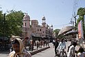
Khandwa is a city and a nagar nigam in the Nimar region of Madhya Pradesh, India. It is the administrative headquarters of the Khandwa district, formerly known as East Nimar District.

Nimar is the southwestern region of Madhya Pradesh state in west-central India. This region has sub-regions which include Nimar, Khandwa and Harda.

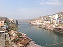
Barwani or Badwani is a municipal town in Barwani district of Madhya Pradesh, India, that is situated near the left bank of the Narmada River. It is the administrative headquarters of Barwani district and has also served as the capital of the former princely state of Barwani. Barwani is only accessible by road.

<span class="mw-page-title-main">Betul district</span> District of Madhya Pradesh in India

Betul district is a district of Madhya Pradesh state in central India. The city of Betul serves as its administrative headquarters. The district is a part of Narmadapuram Division.

<span class="mw-page-title-main">Dewas district</span> District of Madhya Pradesh in India

Dewas District is a district in the Indian state of Madhya Pradesh. The town of Dewas is the district headquarters.

<span class="mw-page-title-main">Khargone district</span> District of Madhya Pradesh in India

Khargone district, formerly known as West Nimar district, is a district of Madhya Pradesh state in central India. The district lies in the Nimar region and is part of the Indore Division. The district headquarters is the city of Khargone, which lies south of the Indore metropolis, the headquarters of Indore district.

<span class="mw-page-title-main">Barwani district</span> District of Madhya Pradesh in India

Barwani district is one of the districts of Madhya Pradesh state of India. The administrative headquarters of the district is at Barwani. Barwani district has an area of 5,427 km² and a population 1,385,881. The district lies in the southwestern corner of Madhya Pradesh; the Narmada River forms its northern boundary. The Satpura Range lies to its south. The district is bordered by Maharashtra state to the south, Gujarat state to the west, Dhar District to the north and Khargone District to the east.

<span class="mw-page-title-main">Burhanpur district</span> District of Madhya Pradesh in India

Burhanpur District is a district of Madhya Pradesh state in central India. The city of Burhanpur is the district headquarters.

<span class="mw-page-title-main">Dhar district, India</span> District of Madhya Pradesh in India

Dhar district is a district of Madhya Pradesh state in central India. The historic town of Dhar is administrative headquarters of the district.

<span class="mw-page-title-main">Hoshangabad district</span> District of Madhya Pradesh in India

Hoshangabad district, officially Narmadapuram district, is one of the districts of Madhya Pradesh state of India, and Hoshangabad city is the district headquarters.

<span class="mw-page-title-main">Khargone</span> City in Madhya Pradesh, India

Khargone is a city and administrative headquarters of an Khargone district in the Indian state of Madhya Pradesh. The city is located on the bank of the Kunda river and is known for its cotton and chilly production. It is also known for Navgraha Mandir, a temple devoted to the nav grahas. Khargone topped the nation in municipality and received a national award for 'India's Fastest Moving City' under a population of two lakh. Khargone ranked 10th Cleanest city in India in Swachh Survekshan 2020 City ranked the 15th cleanest city in India in Swachh Survekshan 2018 and ranked 17th cleanest city in India in Swachh Survekshan 2017.

Barwaha is a municipality and sub district in Khargone district in the state of Madhya Pradesh, India situated on the banks of Narmada river. Barwaha is second biggest city of District after Khargone city. The Barwaha city is divided into 28 wards for which elections are held every 5 years. The Barwaha Municipality has population of 61,973 of which 32,940 are males while 29,033 are females as per report released by Census India 2011. Literacy rate of Barwaha is 87.27% higher than state average of 69.32%. In Barwaha, Male literacy is around 92.73% while female literacy rate is 81.23%.

Mundi is a city and Tehsil in the Khandwa district of Nimar region the Indian state of Madhya Pradesh. It is situated in North Side of East Nimar District.

Pandhana is a town and a Nagar Parishad in Khandwa district in the Indian state of Madhya Pradesh.

Sanawad is an Indian town in Khargone district in the Indian state of Madhya Pradesh. It is a popular center for the trade of cotton and wheat. Nearby cities include Khargone, Khandwa, Barwaha and Indore.

Nimadi is a Western Indo-Aryan language spoken in the Nimar region of west-central India within the state of Madhya Pradesh. This region lies adjacent to Maharashtra and south of Malwa. The districts where Nimadi is spoken are: Barwani, Khandwa, Barwaha, Khargone, Burhanpur, Bedia, Sanawad and parts of Dhar, Harda and South Dewas districts. The famous writers of Nimari were Gaurishankar Sharma, Ramnarayan Upadhyay, surendra khede etc.

Mundi Area is an area of the Khandwa District in the Madhya Pradesh state of central India. The city of Mundi is the administrative headquarters of the area.

<span class="mw-page-title-main">Nerbudda Division</span>

The Nerbudda Division, named after the Narmada River (Nerbudda), was a former administrative division of the Central Provinces of British India. It encompassed a good part of the Narmada River basin in the eastern part of present-day Madhya Pradesh state of India. The Nerbudda Division had an area of 47,609.2 km2 with a population of 1,785,008 in 1901.

Kenud is a village of the Punasa tehsil of Khandwa district, in Madhya Pradesh state, India. Village is founded by Joraji Singh Badal. Kenud village was established on 8 October 1818 on Navami Tithi of Shardiya Navratri in the Shukla Paksha of the Ashwin month. The land around The 1500 acre was bought in ₹1100 from British Raj by the founder. Presently most of the people of the village depend on agriculture, workers and youth are dependent on the nearby city of Mundi and Shree Singaji Thermal Power Project for employment.

References

  1. Hunter, William Wilson, Sir, et al. (1908). Imperial Gazetteer of India, Volume 6. 1908-1931; Clarendon Press, Oxford
  2. 1 2 Ministry of Panchayati Raj (8 September 2009). "A Note on the Backward Regions Grant Fund Programme" (PDF). National Institute of Rural Development. Archived from the original (PDF) on 5 April 2012. Retrieved 27 September 2011.
  3. "Table A-02 Decadal Variation in Population Since 1901: Madhya Pradesh" (PDF). census.gov.in. Registrar General and Census Commissioner of India.
  4. 1 2 3 4 5 6 "District Census Handbook: Khandwa" (PDF). Census of India . Registrar General and Census Commissioner of India. 2011.
  5. "Table C-01 Population By Religion: Madhya Pradesh". census.gov.in. Registrar General and Census Commissioner of India.
  6. 1 2 "Table C-16 Population by Mother Tongue: Madhya Pradesh". censusindia.gov.in. Registrar General and Census Commissioner of India.
  7. M. Paul Lewis, ed. (2009). "Bareli, Rathwi: A language of India". Ethnologue: Languages of the World (16th ed.). Dallas, Texas: SIL International. Retrieved 28 September 2011.[ permanent dead link ]
  8. Brierley, Saroo (2013). A Long Way Home. Viking, Australia ISBN   9780670077045

21°49′48″N76°20′24″E / 21.83000°N 76.34000°E / 21.83000; 76.34000