Raisen district

Last updated

Raisen district
Stupa 1 - North Side - Sanchi Hill 2013-02-21 4275.JPG
Bheem Baithika Caves Paintings (11).jpg
View from the steps to the raisen fort 03.jpg
Bhojeshwar Temple.jpg
016 More small Stupas (33567800241).jpg
Clockwise from top-left: Great Stupa of Sanchi, Bhimbetka rock shelters, Bhojeshwar Temple, stupas at Satdhara, view of Raisen Fort
MP Raisen district map.svg
Location of Raisen district in Madhya Pradesh
Coordinates(Raisen): 23°19′N77°47′E / 23.317°N 77.783°E / 23.317; 77.783
CountryFlag of India.svg  India
State Madhya Pradesh
Division Bhopal
Headquarters Raisen
Tehsils 10
  1. Raisen,
  2. Goharganj
  3. Begamganj
  4. Gairatganj
  5. Silwani
  6. Bareli
  7. Udaipura
  8. Deori
  9. Sultanpur
  10. Badi
Area
  Total8,399 km2 (3,243 sq mi)
Population
 (2011)
  Total1,331,597
  Density160/km2 (410/sq mi)
Demographics
   Literacy 74.26 per cent
  Sex ratio899
Time zone UTC+05:30 (IST)
Website raisen.nic.in

Raisen District is a district of Madhya Pradesh state of India. The town of Raisen is the district headquarters. The district is part of Bhopal Division. Sanchi University of Buddhist-Indic Studies is the first international university located at Sanchi Town.

Contents

Etymology

Raisen District takes its name from Raisen town, which is named after a fort. This fort is built on a sandstone hill, at the foot of which settles the town. The name is probably a corruption of Rajavasini or Rajasayan, the royal residence. [1]

Geography

Raisen district is situated between the latitude 22 47' and 23 33' north and the longitude 7721' and 78 49' east. Sehore District lies in west, Vidisha district in the north, Sagar district in the east and south-east, Narsimhapur district in the south-east, Narmadapuram and Sehore districts in the south. It covers an area of 8,395 square kilometres (3,241 sq mi). [2]

Raisen district has Ten tehsils – Raisen, Goharganj, Begamganj, Gairatganj, Silwani, Bareli, Udaipura, Deori, Sultanpur and Badi. [2]

History

The territory of the present-day Raisen district was once part of the Nizamat-A-Mashrif district of the Bhopal princely state. After the Bhopal State of independent India came into being, Raisen was declared a separate district on 5 May 1950. [3]

The Buddhist monuments at Sanchi, a UNESCO World Heritage Site, are located in Raisen district. [4] Bhimbetka rock shelters, another UNESCO World Heritage Site, are also located in Raisen district. [5]

Demographics

Young girls in Raisen district Young Indian girls, Raisen district, Madhya Pradesh.jpg
Young girls in Raisen district
Historical population
YearPop.±% p.a.
1901295,219    
1911320,640+0.83%
1921301,575−0.61%
1931296,365−0.17%
1941310,369+0.46%
1951315,358+0.16%
1961411,426+2.69%
1971553,026+3.00%
1981710,542+2.54%
1991876,461+2.12%
20011,125,154+2.53%
20111,331,597+1.70%
source: [6]
Religions in Raisen district (2011) [7]
ReligionPercent
Hinduism
89.76%
Islam
9.04%
Jainism
0.80%
Other or not stated
0.40%

According to the 2011 census Raisen District has a population of 1,331,597, [8] roughly equal to the nation of Mauritius [9] or the US state of Maine. [10] This gives it a ranking of 365th in India (out of a total of 640). [8] The district has a population density of 157 inhabitants per square kilometre (410/sq mi) . [8] Its population growth rate over the decade 2001-2011 was 18.36%. [8] Raisen has a sex ratio of 899 females for every 1000 males, [8] and a literacy rate of 74.26%. 22.79% of the population lives in urban areas. Scheduled Castes and Scheduled Tribes make up 16.96% and 15.40% of the population respectively. [8]

Languages of Raisen district (2011) [11]

   Hindi (97.28%)
   Urdu (1.99%)
  Others (0.73%)

At the time of the 2011 Census of India, 97.28% of the population in the district spoke Hindi and 1.99% Urdu as their first language. [11]

Tourism places

Raisen District has many tourism places like:

Transportation

Raisen is 43.8 km from Bhopal, Its connected to Bhopal via NH-86. NH-12 also passes through the district.

Related Research Articles

<span class="mw-page-title-main">Madhya Pradesh</span> State in central India

Madhya Pradesh is a state in central India. Its capital is Bhopal, and the largest city is Indore, with Gwalior, Jabalpur, Ujjain, Dewas, Sagar, Satna, and Rewa being the other major cities. Madhya Pradesh is the second largest Indian state by area and the fifth largest state by population with over 72 million residents. It borders the states of Uttar Pradesh to the northeast, Chhattisgarh to the east, Maharashtra to the south, Gujarat to the west, and Rajasthan to the northwest.

<span class="mw-page-title-main">Vidisha</span> City in Madhya Pradesh, India

Vidisha is a city in central Madhya Pradesh, India. It is located 62.5 km northeast of the state capital, Bhopal. The name "Vidisha" is derived from the nearby river "Bais", mentioned in the Puranas.

<span class="mw-page-title-main">Sehore</span> City in Madhya Pradesh, India

Sehore is a city and a municipality in Sehore district in the Indian state of Madhya Pradesh. It is the district headquarters of Sehore District and is located on the Bhopal-Sehore-Indore highway, 38 km from Bhopal.

<span class="mw-page-title-main">Bhopal division</span> Administrative division of Madhya Pradesh, India

Bhopal Division is an administrative geographical unit of Madhya Pradesh state of central India. Bhopal is the administrative headquarters of the division. The division consists of districts of Bhopal, Raisen, Rajgarh, Sehore, and Vidisha.

<span class="mw-page-title-main">Dewas district</span> District of Madhya Pradesh in India

Dewas District is a district in the Indian state of Madhya Pradesh. The town of Dewas is the district headquarters.

<span class="mw-page-title-main">Guna district</span> District in Madhya Pradesh, India

Guna district is one of the 52 districts of Madhya Pradesh in central India. Its administrative headquarters is Guna. The district has a population of 1,241,519. It has an area of 6390 km², and is bounded on the northeast by Shivpuri District, on the east by Ashoknagar District, on the southeast by Vidisha District, on the southwest by Rajgarh District, on the west and northwest by Jhalawar and Baran districts of Rajasthan state. The Sindh River flows northward along the eastern edge of the district, forming part of the boundary with Ashoknagar District, and the Parvati River flows northwestward through the southern portion of the district, forming part of the boundary with Baran District before flowing into Rajasthan.

<span class="mw-page-title-main">Vidisha district</span> District of Madhya Pradesh in India

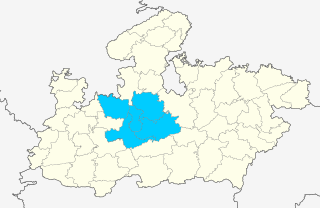
Vidisha District (विदिशा) is in Madhya Pradesh state, in central India. The city of Vidisha is the administrative headquarters of the district.

<span class="mw-page-title-main">Bhopal district</span> District of Madhya Pradesh in India

Bhopal District is a district of Madhya Pradesh state in central India. The city of Bhopal serves as its administrative headquarters. The district is part of Bhopal Division.

<span class="mw-page-title-main">Sehore district</span> District of Madhya Pradesh in India

Sehore District is a district of Madhya Pradesh state in central India. The town of Sehore is the district headquarters. The district is part of Bhopal Division.

<span class="mw-page-title-main">Raisen</span> Town in Madhya Pradesh, India

Raisen is a town and a municipality in Raisen district in the Indian state of Madhya Pradesh. It is the administrative headquarters of Raisen District. Raisen takes its name from the massive fort at the top of a hill. The town is located at the foot. The name is probably a corruption of Rajavasini or Rajasayan—the royal residence. The famous places to visit in Raisen district are Raisen Fort, Dargah, and Sanchi Stupa. Raisen is 45.5 km (28.3 mi) from the state capital Bhopal.

Begumganj is a town and a municipality in Raisen district in the state of Madhya Pradesh, India. and is located on the Bhopal - Sagar National Highway 120 km away from Bhopal. It is one of the five divisions of the Raisen district.

Gairatganj is a City and Nagar Panchayat in Raisen district in the state of Madhya Pradesh, India.

<span class="mw-page-title-main">Tribals in Madhya Pradesh</span> Major tribes of the state of Madhya Pradesh and their population

There are 46 recognized Scheduled Tribes in Madhya Pradesh, India, three of which have been identified as "Particularly Vulnerable Tribal Groups" or "PTGs". The population of Scheduled Tribals (ST) is 21.1 per cent of the state population, according to the 2011 census. Bounded by the Narmada River to the north and the Godavari River to the southeast, tribal peoples occupy the slopes of the region's mountains.

National Highway 146 is a National Highway in India. This highway is in the state of Madhya Pradesh, running from Bhopal to Sagar. This national highway is 167.6 km (104.1 mi) long. Before renumbering of national highways, NH-146 was numbered as old national highways 86.

<span class="mw-page-title-main">Sanchi Town</span> Nagar panchayat in Madhya Pradesh, India

Sanchi Town is a Nagar panchayat, near Raisen town in Raisen District of the state of Madhya Pradesh, India, it is located 46 km (29 mi) north east of Bhopal, and 10 km (6.2 mi) from Besnagar or Vidisha in the central part of the state of Madhya Pradesh. Known for its "Sanchi Stupas", it is the location of several Buddhist monuments dating from the 3rd century BC to the 12th CE and is one of the important places of Buddhist pilgrimage.

<span class="mw-page-title-main">Vidisha Assembly constituency</span> Constituency of the Madhya Pradesh legislative assembly in India

Vidisha Assembly constituency Vidhan Sabha seat is one of the 230 Vidhan Sabha constituencies of Madhya Pradesh state in central India. This constituency came into existence in 1957, as one of the Vidhan Sabha constituencies of Madhya Pradesh state. Presently INC's Shashank Bhargava is the MLA from this constituency. He was preceded by Kalyan Singh Thakur in 2014 when the by-election for this seat was held in 2014 after CM of Madhya Pradesh Shivraj Singh Chouhan resigned from this constituency post registering victory at two seats Budhni and Vidisha Assembly constituency.

<span class="mw-page-title-main">Basoda Assembly constituency</span> Constituency of the Madhya Pradesh legislative assembly in India

Basoda Assembly constituency is one of the 230 Vidhan Sabha constituencies of Madhya Pradesh state in central India. This constituency came into existence in 1962, as one of the Vidhan Sabha constituencies of Madhya Pradesh state.

Sukhi Sewaniya is a village in the Bhopal district of Madhya Pradesh, India. It is located in the Huzur tehsil and the Phanda block. Located near the Bhopal Bypass road, it has gradually developed into a suburb of the Bhopal city.

<span class="mw-page-title-main">Sanchi railway station</span> Railway station in Madhya Pradesh, India

Sanchi railway station is a small railway station in Raisen district, Madhya Pradesh. Its code is SCI. It serves Sanchi Town. The station consists of two platforms, neither well sheltered. It lacks many facilities including water and sanitation. The station is located around 1.5 km away from UNESCO World Heritage Site of Sanchi stupas.

References

  1. "History | District Raisen, Government of Madhya Pradesh | India" . Retrieved 21 May 2021.
  2. 1 2 "Raisen". Raisen district administration. Retrieved 14 August 2010.
  3. "District Census Handbook - Raisen" (PDF). 2011 Census of India . Directorate of Census Operations, Madhya Pradesh. Retrieved 21 July 2015.
  4. "An Historical and Artistic Description of Sanchi (1918)". Archived from the original on 10 February 2009. Retrieved 14 August 2010.
  5. "Rock Shelters of bhimbhetka". UNESCO. Retrieved 14 August 2010.
  6. "Table A-02 Decadal Variation in Population Since 1901: Madhya Pradesh" (PDF). census.gov.in. Registrar General and Census Commissioner of India.
  7. "Table C-01 Population By Religion: Madhya Pradesh". census.gov.in. Registrar General and Census Commissioner of India.
  8. 1 2 3 4 5 6 "District Census Handbook: Raisen" (PDF). Census of India . Registrar General and Census Commissioner of India. 2011.
  9. US Directorate of Intelligence. "Country Comparison:Population". Archived from the original on 13 June 2007. Retrieved 1 October 2011. Mauritius 1,303,717 July 2011 est.
  10. "2010 Resident Population Data". U. S. Census Bureau. Retrieved 30 September 2011. Maine 1,328,361
  11. 1 2 "Table C-16 Population by Mother Tongue: Madhya Pradesh". censusindia.gov.in. Registrar General and Census Commissioner of India.