Harda district

Last updated
Harda district
Ridhanath Riddheshwar mandir, Handia Madhya Pradesh 003.jpg
Makdai fort.jpg
Top: Ridhanath Riddheshwar Temple, Handia
Bottom: Makrai Fort
MP Harda district map.svg
Location of Harda district in Madhya Pradesh
Coordinates(Harda): 22°20′N77°05′E / 22.333°N 77.083°E / 22.333; 77.083
CountryFlag of India.svg  India
State Madhya Pradesh
Division Narmadapuram
Headquarters Harda
Tehsils Harda, Sirali, Khirkiya, Handiya, Rahatgaon
Government
   Lok Sabha constituencies Betul
Area
  Total2,644 km2 (1,021 sq mi)
Population
 (2011)
  Total570,465
  Density220/km2 (560/sq mi)
Demographics
   Literacy 74.04 per cent
  Sex ratio932
Time zone UTC+05:30 (IST)
Website harda.nic.in

Harda District is a district of Madhya Pradesh state of central India. The town of Harda is the district headquarters. The district is part of Narmadapuram Division. Harda district was organized in 1998. Harda is also known as 'Hridaynagari' (Also "BHuana: Fertile Land").

Contents

The district has an area 2644 km2, and a population 570,465 (2011 census), a 20.25% increase from 2001. Harda District is bounded by the districts of Sehore to the north, Narmadapuram to the northeast, Betul to the southeast, Khandwa to Narmadapuram District. It is part of the Narmadapuram Division of Madhya Pradesh.

Harda lies in the Narmada River valley, and the Narmada forms the district's northern boundary. The land rises towards the Satpura Range to the south. The movies Amma ki boli, Matrubhoomi, which deals with the consequences of female infanticide, was filmed in the Ranhai Kala of this district.

One of the youngest freedom movement participant from central India Guru Radha Kishan was born in 1925 in BID village of the district. Guru Radha Kishan openly challenged a British Police Official and slapped him in front of a large gathering while the officer started abusing Indians in a freedom movement rally in Indore. A widely respected Swatantrata Sangram Senani known for his integrity, honesty and transparency. He fought valiantly for the economic deprivation for the poor and underprivileged classes of society.

As of 2011 it is the least populous district of Madhya Pradesh (out of 50). [1]

Demographics

Historical population
YearPop.±% p.a.
1901132,349    
1911135,977+0.27%
1921132,067−0.29%
1931144,560+0.91%
1941144,806+0.02%
1951146,513+0.12%
1961187,140+2.48%
1971240,435+2.54%
1981294,835+2.06%
1991380,762+2.59%
2001474,416+2.22%
2011570,465+1.86%
source: [2]

According to the 2011 census Harda District has a population of 570,465, [1] roughly equal to the nation of Solomon Islands [3] or the US state of Wyoming. [4] This gives it a ranking of 534th in India (out of a total of 640). [1] The district has a population density of 171 inhabitants per square kilometre (440/sq mi) . [1] Its population growth rate over the decade 2001-2011 was 20.25%. [1] Harda has a sex ratio of 932 females for every 1000 males, [1] and a literacy rate of 74.04%. 20.92% of the population lives in urban areas. Scheduled Castes and Scheduled Tribes made up 16.28% and 27.99% of the population respectively. [1]

Religions in Harda district (2011) [5]
ReligionPercent
Hinduism
92.46%
Islam
6.77%
Other or not stated
0.77%

Hindus are 92.46% and Muslims are 6.77% of the population.

Languages of Harda district (2011) [6]

   Hindi (89.88%)
   Korku (6.52%)
   Gondi (1.76%)
  Others (1.84%)

At the time of the 2011 Census of India, 89.88% of the population in the district spoke Hindi, 6.52% Korku and 1.76% Gondi as their first language. [6]

Government and politics

Harda (district) has two assembly seats in the Madhya Pradesh Legislative Assembly: Harda (Harda, Khirkiya) and Timarni (Timarni, Sirali). As of 2023, the MLA from Harda is Dr. Ramkishore Dogne and Abhijeet Shah Makdai is the MLA from Timarni. [ needs update ]

Tourist places

See also

Related Research Articles

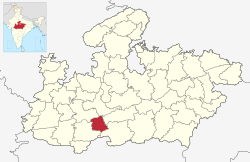
Harda is a city and a municipality in Harda district in the Indian state of Madhya Pradesh. Harda is the administrative headquarters of Harda.

<span class="mw-page-title-main">Narmada district</span> District of Gujarat in India

Narmada district is an administrative district in the state of Gujarat in India. The district headquarters are located at Rajpipla. The district is bounded by Vadodara and Chhota Udaipur districts in the north, by Nandurbar district of Maharashtra state in the east, by Surat and Tapi districts in the south and by Bharuch district in the west. The district occupies an area of 2,755 km2 and has a population of 590,297. It was 10.44% urban as of 2011. As of 2011, it is the third least populous district of Gujarat, after Dang and Porbandar.

<span class="mw-page-title-main">Betul district</span> District of Madhya Pradesh in India

Betul district is a district of Madhya Pradesh state in central India. The city of Betul serves as its administrative headquarters. The district is a part of Narmadapuram Division.

<span class="mw-page-title-main">Raisen district</span> District of Madhya Pradesh in India

Raisen District is a district of Madhya Pradesh state of India. The town of Raisen is the district headquarters. The district is part of Bhopal Division. Sanchi University of Buddhist-Indic Studies is the first international university located at Sanchi Town.

<span class="mw-page-title-main">Sheopur district</span> District of Madhya Pradesh in India

Sheopur District is a district of Madhya Pradesh state in central India. The district is located in the north of the state and forms part of Chambal division. It is situated on the periphery of Rajasthan, which shows in the influence of Rajasthani culture in this district.

<span class="mw-page-title-main">Katni district</span> District of Madhya Pradesh in India

Katni District, also known as Murwara District, is one of the 55 districts of Madhya Pradesh state in central India. The town of Katni (Murwara) is the District headquarters. The District is part of Jabalpur Division. The District occupies an area of 4949.59 km2.

<span class="mw-page-title-main">Mandla district</span> District of Madhya Pradesh in India

Mandla District is a district of Madhya Pradesh in central India. The town of Mandla is the administrative headquarters of the district. It is part of Jabalpur Division.

<span class="mw-page-title-main">Narsinghpur district</span> District of Madhya Pradesh in India

Narsinghpur district is a district of Madhya Pradesh state in central India. Vindhyachal is on its northern border and the Satpura range extends along its entire length on the southern border. In the northern part, the Narmada river flows from east to west. Latitude 22º.45N 23º.15N, Longitude 78º.38E 79º.38E, Area 5125.55 Square Kilometers, 359.8 meters above sea level. The city of Narsinghpur is administrative headquarters of the district. As of 2001 Narsinghpur is the most literate district of MP.

<span class="mw-page-title-main">Barwani district</span> District of Madhya Pradesh in India

Barwani district is one of the districts of Madhya Pradesh state of India. The administrative headquarters of the district is at Barwani. Barwani district has an area of 5,427 km² and a population 1,385,881. The district lies in the southwestern corner of Madhya Pradesh; the Narmada River forms its northern boundary. The Satpura Range lies to its south. The district is bordered by Maharashtra state to the south, Gujarat state to the west, Dhar District to the north and Khargone District to the east.

<span class="mw-page-title-main">Burhanpur district</span> District of Madhya Pradesh in India

Burhanpur District is a district of Madhya Pradesh state in central India. The city of Burhanpur is the district headquarters.

<span class="mw-page-title-main">Anuppur district</span> District of Madhya Pradesh in India

Anuppur District (अनूपपुर) is an administrative district in Shahdol Division of Madhya Pradesh state in central India.

<span class="mw-page-title-main">Dhar district, India</span> District of Madhya Pradesh in India

Dhar district is a district of Madhya Pradesh state in central India. The historic town of Dhar is administrative headquarters of the district.

<span class="mw-page-title-main">Hoshangabad district</span> District of Madhya Pradesh in India

Hoshangabad district, officially Narmadapuram district, is one of the districts of Madhya Pradesh state of India, and Hoshangabad city is the district headquarters.

<span class="mw-page-title-main">Khandwa district</span> District of Madhya Pradesh in India

Khandwa district, formerly known as the East Nimar district, is a district of the Madhya Pradesh state in central India. The city of Khandwa is the administrative headquarters of the district. Other notable towns in the district include Mundi, Harsud, Pandhana and Omkareshwar.

<span class="mw-page-title-main">Jabalpur district</span> District of Madhya Pradesh in India

Jabalpur district is a district of Madhya Pradesh state in central India. The city of Jabalpur is the administrative headquarters of the district.

<span class="mw-page-title-main">Sehore district</span> District of Madhya Pradesh in India

Sehore District is a district of Madhya Pradesh state in central India. The town of Sehore is the district headquarters. The district is part of Bhopal Division.

Seoni Malwa is a city and a municipality in Narmadapuram district in the Indian state of Madhya Pradesh.

Rahatgaon is a small town in Harda District, Madhya Pradesh. It lies about 22 km south of Harda and about 50 km east of Harsud. Bhopal is 178 km away from Rahatgaon. Timarni, Nemawar, Khirkiya and Kesla constitute interesting excursions. Harda Railway Station serves the town. Holy Narmada river is about 40 km from the city.

Banapura is a small town in the Hoshangabad District of Madhya Pradesh, India. Banapura is a twin city of Seoni Malwa.

Handia is a village in Madhya Pradesh state of India. It is located in the Handiya block and tehsil of the Harda district. Handia is located on the left bank of the Narmada river; Nemawar is located on the opposite side, which belongs to Dewas district.

References

  1. 1 2 3 4 5 6 7 "District Census Handbook: Harda" (PDF). Census of India . Registrar General and Census Commissioner of India. 2011.
  2. "Table A-02 Decadal Variation in Population Since 1901: Madhya Pradesh" (PDF). census.gov.in. Registrar General and Census Commissioner of India.
  3. US Directorate of Intelligence. "Country Comparison:Population". Archived from the original on June 13, 2007. Retrieved 2011-10-01. Solomon Islands 571,890 July 2011 est.
  4. "2010 Resident Population Data". U. S. Census Bureau. Archived from the original on 2010-12-27. Retrieved 2011-09-30. Wyoming 563,626
  5. "Table C-01 Population By Religion: Madhya Pradesh". census.gov.in. Registrar General and Census Commissioner of India.
  6. 1 2 "Table C-16 Population by Mother Tongue: Madhya Pradesh". censusindia.gov.in. Registrar General and Census Commissioner of India.