
Vindhya Pradesh was a former state of India. It occupied an area of 61,131.5 km2. It was created in 1948 as Union of Baghelkhand and Bundelkhand States, shortly after Indian independence, from the territories of the princely states in the eastern portion of the former Central India Agency. It was named as Vindhya Pradesh on 25 January 1950 after the Vindhya Range, which runs through the centre of the province. The capital of the state was the former princely state of Rewa. It lays between Uttar Pradesh to the north and Madhya Pradesh to the south, and the enclave of Datia, which lay a short distance to the west, was surrounded by the state of Madhya Bharat.

Rewa is a city in the north-eastern part of Madhya Pradesh state in India. It is the administrative center of Rewa District and Rewa Division. The city lies about 420 kilometres (261 mi) northeast of the state capital Bhopal and 230 kilometres (143 mi) north of the city of Jabalpur. The maximum length of Rewa district is 125 km from east to west and the length of Rewa from north to south is 96 km. This area is surrounded by Kaimur hills to the south Vindhyachal ranges pass through the middle of the district.

Rewa district is a district of the Madhya Pradesh state in central India. The city of Rewa is the district headquarter. Rewa is sometimes called the "Land of White Tigers", as the first White Tiger was discovered here in 1951 by the Maharaja of the province, Martand Singh, in the nearby jungle of Govindgarh. Rewa was the capital city of a former state, Vindhya Pradesh.

Rewa Division is an administrative geographical unit of Madhya Pradesh state of India situated in the northeast part of state bordering with Uttar Pradesh, Chhattisgarh and Baghelkhand region of Madhya Pradesh. Rewa is the administrative headquarters of the division. As of 2024, the division consists of districts of Rewa, Satna, Sidhi, Singrauli, Mauganj and Maihar. The division forms a part of the Baghelkhand region of Madhya Pradesh. The divisional headquarters in the Kothi Compound area of Rewa.

Satna is a city in the Indian state of Madhya Pradesh. It serves as the headquarters of Satna district. It is 7th largest city and 8th most populous city of the state. The city is 500 km east of the state capital Bhopal. The city is distributed over a land area of 111.9 square kilometres.
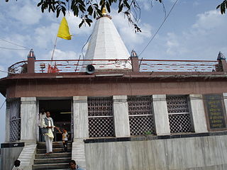
Maihar is a city in the Maihar district of the Indian state of Madhya Pradesh. Maihar is known for the temple of the revered mother goddess Sharda situated
Katni officially Murwara is a city on the banks of the Katni River in Madhya Pradesh, India. It is the administrative headquarters of Katni District. It is in the Mahakoshal region of central India. The city is 90 km (56 mi) from the divisional headquarters of the region, Jabalpur.
Amarpatan is a municipal city in Maihar district in the state of Madhya Pradesh, India.
Birsinghpur is a sub district in Satna District in the state of Madhya Pradesh, India
Kymore is an industrial town and a nagar panchayat in Vijayraghavgarh tehsil in Katni district in the Indian state of Madhya Pradesh. Known mainly for its cement works established in 1921 by J. K. Fisher.

Satna District is a district of Madhya Pradesh state in central India. The city of Satna is the district headquarters. The district has an area of 7,502 km2, and a population of 22,28,935(2011 census), 20.63% of which is urban. The district has a population density of 249 persons per km2.

Govindgarh, the summer capital of Mahraja Rewa, is about 18 km from Rewa in Madhya Pradesh, India. The is Rewa, with an area of about 13,000 mi², was the largest princely state in the Bagelkhand Agency and the second largest in Central India Agency. The British political agent for Bagelkhand resided at Satna, on the East Indian railway. The Bagelkhand capital establish in Rewa under the Rewa Maharaja.Bagheli is the local language of the region.It's neighbouring towns are Manikawar, Gurh and Rewa.

Kaimur Range is the eastern portion of the Vindhya Range, about 483 kilometres (300 mi) long, extending from around Katangi in Jabalpur district of Madhya Pradesh to around Sasaram in Rohtas district of Bihar. It passes through the Rewa and Mirzapur divisions. The range never rises more than a few hundred metres above the surrounding plains and has a maximum width of around 80 km.

Rampur-Baghelan Assembly constituency is one of the 230 Vidhan Sabha constituencies of Madhya Pradesh state in central India. This constituency came into existence in 1951, as one of the 48 Vidhan Sabha constituencies of the erstwhile Vindhya Pradesh state. This constituency was abolished in 1961 but came into existence again in 1966.

Amarpatan Assembly constituency is one of the 230 Vidhan Sabha constituencies of Madhya Pradesh state in central India. This constituency came into existence in 1951, as one of the 48 Vidhan Sabha constituencies of the erstwhile Vindhya Pradesh state.

Nagod Assembly constituency is one of the 230 Vidhan Sabha constituencies of Madhya Pradesh state in central India. This constituency came into existence in 1951, as one of the 48 Vidhan Sabha constituencies of the erstwhile Vindhya Pradesh state, but it was abolished in 1956. It again came into existence in 1966, following the delimitation of the legislative assembly constituencies.
Dubahiyan is a village in Nagod Tahsil, Satna district in the Indian state of Madhya Pradesh. Dubahiyan is about 28 kilometres southwest of the district headquarters, Satna and 8 kilometres southwest of Nagod.
New Deorajnagar is a town in Madhya Pradesh state in central India. Ramnagar, Madhya Pradesh is nearest town from it. District headquarters of New Deorajnagar is the Satna District. It is approximately 65 kilometres from the city of Satna, 25 kilometers from Amarpatan and 5 kilometres from Ramnagar, Madhya Pradesh. On southern side it is surrounded by Bansagar Dam and on other side is Gidhakoot (Gidhaila).
Madhyanchal Gramin Bank is a regional rural bank in India. It is under the ownership of Ministry of Finance, Government of India. It was formed by merging three rural banks in the state of Madhya Pradesh in central India namely Madhya Bharat Bank, Sharda Grameen Bank, Rewa Sidhi Grameen Bank, sponsored by State Bank Of India, Allahabad Bank and Union Bank of India. Its headquarters is in Saugor. Current sponsor of the bank is State Bank of India. Madhyanchal Gramin Bank has presence over 15 districts in Madhya Pradesh Damoh, Sagar, Shivpuri, Guna, Ashoknagar, Tikamgarh, Chhatarpur, Panna, Satna, Rewa, Sidhi, Niwari ,Mauganj, Maihar and Singrauli. There are 454 branch and 7 regional offices in Rewa, Sidhi, Satna, Damoh, Shivpuri, Chhatarpur and Tikamgarh.

Maihar is one of the 230 Vidhan Sabha constituencies of Madhya Pradesh state in central India. This constituency came into existence in 1951. It is one of the 7 Vidhan Sabha constituencies located in Satna district. The constituency is part of Satna Lok Sabha constituency. As of 2023, its representative is Srikant Chaturvedi of the Bharatiya Janata Party.

