Mandsaur district

Last updated
Mandsaur district
0111321 Pasupatinath temple, Mandsaur Madhya Pradesh 008.jpg
0111321 Sondhni Vijayastambha, Mandasor Victory Pillars site, Mandsaur Madhya Pradesh 019.jpg
0111421 Dhamnar Dharmanatha group of rock-cut Nagara temples, Chandwasa 067.jpg
Gandhi Sagar Mandsaur1.JPG
Prehistoric Painted Rock Shelters at Chatarbhuj Nala outlook.jpg
Clockwise from top-left: Pashupatinath Temple, Mandsaur, Sondhni Vijayasthambha, Gandhi Sagar, Chatarbhuj Nala rock shelters, Chandwasa Dharmanatha temples
MP Mandsaur district map.svg
Location of Mandsaur district in Madhya Pradesh
CountryFlag of India.svg  India
State Madhya Pradesh
Division Ujjain
Headquarters Mandsaur
Tehsils 9
Government
   Lok Sabha constituencies Mandsaur
Area
  Total9,791 km2 (3,780 sq mi)
Population
 (2011)
  Total1,340,411
  Density140/km2 (350/sq mi)
Demographics
   Literacy 71.78 per cent [1]
  Sex ratio966
Time zone UTC+05:30 (IST)
Vehicle registration MP-14
Website mandsaur.nic.in
Idol of Lord Pashupatinath in Mandsaur Pashupatinath Mandsaur.jpg
Idol of Lord Pashupatinath in Mandsaur

Mandsaur district is a District of Madhya Pradesh state in central India. The town of Mandsaur is the administrative headquarters of the district.The ancient Pashupatinath temple is situated in Mandsaur. Large quantities of opium are produced in Mandsaur district.

Contents

Origin of name

The District takes its name from the headquarters town, Mandsaur. It is considered to have been evolved from Marhsaur, originating from Marh and Saur or Dasaur, two of the villages which merged in the town. The town was known as Dashpur during ancient times. Other etymology claims it derives from Mandodari, wife of Ravana, who is said to have been born in the district.

Geography

The district has an area of 9,791 km2 (3,780 sq mi). The district is present on the border of the Mewar and Malwa so the culture is the combination of the both regions, and is bounded by Neemuch District to the north west, Chittorgarh district to North east, Kota district and Jhalawar district to east and Pratapgarh District, and Ratlam District to the south. It is part of Ujjain Division.

Mandsaur District forms the northern projection of Madhya Pradesh from its western Division, i.e., Ujjain Commissioner's Division. It lies between the parallels of latitude 230 45' 50" North and 250 2' 55" North, and between the meridians of longitude 740 42' 30" East and 750 50' 20" East.

The district is an average-size district of Madhya Pradesh. It extends for about 142 km (88 mi). from north to south and 124 km (77 mi) from east to west.

Climate

The climate of this district is generally dry except in south-west monsoon. Year may be divided into four seasons. The cold season is from December to February. This is followed by the hot season from March to the middle of June. Thereafter the south-west monsoon season starts and continues up to about the middle of September.

The average annual rainfall in the District is 786.6 mm (30.97 in). The rainfall in the districts in the region round about Sitamau- Mandsaur- Malhargarh, and in general increases in the northern part of the district from the west towards the east. The heaviest rainfall in 24 hours recorded at any station in the district was 323.9 mm (12.75 in). at Garoth on 1945 June 29.

In the district there is rapid increase in temperatures after February. May is generally the hottest month with the mean daily maximum temperature at 39.80 °C (103.64 °F) and the mean daily minimum at 25.40 °C (77.72 °F). Days are intensely hot in summer and hot dust-laden winds which below during this season add to the discomfort. On individual days in the summer session and in June before the onset of the monsoon the day temperatures often go up above 45 °C (113 °F). January is the coldest month, with the mean daily maximum temperature at 35.00 °C (95.00 °F) and mean daily minimum at 9.30 °C (48.74 °F).

Industry

Opium production and the slate pencil industry are important to the district's economy. Some parts of the district have wind farms.

Divisions

The district is divided into four sub divisions and nine tehsils. The sub divisional headquarters are at Mandsaur, Malhargarh, Sitamau and Garoth. Where, Mandsaur, Malhargarh, Garoth, Shamgarh, Dalauda, Bhanpura, Suwasra and Sitamau and kayampur mandsur are nine tehsils of District.

Vehicle number plates beginning with MP-14 are identified as a registered vehicle under the properly followed rules and regulations.

Demographics

Historical population
YearPop.±% p.a.
1901204,438    
1911230,616+1.21%
1921238,620+0.34%
1931270,796+1.27%
1941319,362+1.66%
1951373,755+1.59%
1961467,595+2.27%
1971593,319+2.41%
1981775,281+2.71%
1991956,869+2.13%
20011,183,724+2.15%
20111,340,411+1.25%
source: [2]
Religions in Mandsaur district (2011) [3]
ReligionPercent
Hinduism
88.97%
Islam
9.37%
Jainism
1.42%
Other or not stated
0.24%

According to the 2011 census Mandsaur District has a population of 1,340,411, [1] roughly equal to the nation of Mauritius [4] or the US state of Maine. [5] This gives it a ranking of 361st in India (out of a total of 640). [1] The district has a population density of 242 inhabitants per square kilometre (630/sq mi). [1] Its population growth rate over the decade 2001-2011 was 13.19%. [1] Mandsaur has a sex ratio of 966 females for every 1000 males, [1] and a literacy rate of 72.75%. 20.71% of the population lives in urban areas. Scheduled Castes and Scheduled Tribes make up 18.58% and 2.47% of the population respectively. [1]

Languages of Mandsaur district (2011) [6]

   Mewari (94.13%)
   Malvi (3.58%)
  Others (2.29%)

At the time of the 2011 Census of India, 94.13% of the population in the district spoke Mewari as their first language and 3.58% of the population spoke Malvi . [6]

Culture

The temple of Lord Pashupatinath is located on the bank of the Shivna. The most common language is mixture of Mewari and Malwi (Rajasthani).

Villages

Related Research Articles

<span class="mw-page-title-main">Madhya Pradesh</span> State in central India

Madhya Pradesh is a state in central India. Its capital is Bhopal, and the largest city is Indore, with Gwalior, Jabalpur, Ujjain, Dewas, Sagar, Satna, and Rewa being the other major cities. Madhya Pradesh is the second largest Indian state by area and the fifth largest state by population with over 72 million residents. It borders the states of Uttar Pradesh to the northeast, Chhattisgarh to the east, Maharashtra to the south, Gujarat to the west, and Rajasthan to the northwest.

<span class="mw-page-title-main">Ujjain</span> City in Madhya Pradesh, India

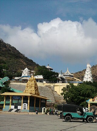
Ujjain or Ujjayinī is a city in Ujjain district of the Indian state of Madhya Pradesh. It is the fifth-largest city in Madhya Pradesh by population and is the administrative centre of Ujjain district and Ujjain division. It is one of the Hindu pilgrimage centres of Sapta Puri famous for the Kumbh Mela (Simhastha) held there every 12 years. The famous temple of Mahakaleshwar Jyotirlinga is located in the center of the city. The city has been one of the most prominent trade and political centres of the Indian Subcontinent from the time of the ancient Mahājanapadas until the British colonisation of India.

<span class="mw-page-title-main">Ratlam</span> City in Madhya Pradesh, India

Ratlam is a city in the northwestern part of the Malwa region in Madhya Pradesh state of India. The city of Ratlam lies 480 metres (1,570 ft)above sea level. It is the administrative headquarters of Ratlam district, which was created in 1947 after the independence of India. It is located 294 kilometres west of the state capital Bhopal.

<span class="mw-page-title-main">Mandsaur</span> City in Madhya Pradesh, India

Mandsaur is a city and a municipality in Mandsaur district located on the border of Mewar and Malwa regions of Madhya Pradesh, a state in Central India. It is the administrative headquarters of Mandsaur District. The ancient Pashupatinath Temple is located in Mandsaur.

Kanad is a town and a nagar parishad in Agar Malwa district in the Indian state of Madhya Pradesh. It comes under Kanad Parishad. It belongs to Ujjain Division. It is situated along the Agar–Sarangpur SH-41 highway. It is located 18 km (11 mi) towards east from the district headquarters of Agar Malwa, 83 km (52 mi) from Ujjain, 186 km (116 mi) from the state capital of Bhopal.

<span class="mw-page-title-main">Dewas district</span> District of Madhya Pradesh in India

Dewas District is a district in the Indian state of Madhya Pradesh. The town of Dewas is the district headquarters.

<span class="mw-page-title-main">Rewa district</span> City and district of Madhya Pradesh in India

Rewa district is a district of the Madhya Pradesh state in central India. The city of Rewa is the district headquarter. Rewa is sometimes called – 'Land of White Tigers' as the first White Tiger was discovered here in 1951 by Maharaja of the province, Martand Singh in the nearby jungle of Govindgarh. Rewa was the capital city of once a state – Vindhya Pradesh.

<span class="mw-page-title-main">Dhar district, India</span> District of Madhya Pradesh in India

Dhar district is a district of Madhya Pradesh state in central India. The historic town of Dhar is administrative headquarters of the district.

<span class="mw-page-title-main">Ratlam district</span> District of Madhya Pradesh in India

Ratlam District is a district of Madhya Pradesh state in central India. The town of Ratlam is administrative headquarters of the district.

<span class="mw-page-title-main">Neemuch district</span> District of Madhya Pradesh in India

Neemuch district is one of the 53 districts of Madhya Pradesh state in central India. The town of Neemuch is the administrative headquarters of the district.

<span class="mw-page-title-main">Ujjain district</span> District of Madhya Pradesh in India

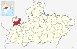
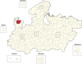
Ujjain district is a district of Madhya Pradesh state in central India. The historic city of Ujjain is the district headquarters. The district has an area of 6,091 km², and a population of 19,86,864, a 16.12% increase from its 2001 population of 17,10,982.

<span class="mw-page-title-main">Chittoor district</span> District of Andhra Pradesh in India

Chittoor district is one of the eight districts in the Rayalaseema region of the Indian state of Andhra Pradesh. It had a population of 18,72,951 at the 2011 census of India. It is a major market centre for mangoes, grains, sugarcane, and peanuts. The district headquarters is at Chittoor City.

<span class="mw-page-title-main">Yamunanagar district</span> District of Haryana in India

Yamunanagar district is one of the 22 districts of the Indian state of Haryana. The district came into existence on 1 November 1989 and occupies an area of 1,756 square kilometres (678 sq mi). Yamunanagar town is the district headquarters.

Garoth is a town in Madhya Pradesh state in central India. It is one of the tehsil of Mandsaur District.It shares boundary with Jhalawar district of Rajasthan.The local Language or dialect spoken here is a mixture of Mewari, Harauti and Malwi Languages.Latitude and longitude coordinates are: 24.328077, 75.649902.

Tarana is a town and a nagar parishad in Ujjain district in the Indian state of Madhya Pradesh. Tarana is a tehsil in Ujjain and the distance to Ujjain is 34 km. Tarana was part of Holkar estate. The current M.L.A of Tarana constituency is Mahesh Parmar (INC).

<span class="mw-page-title-main">Jawad Assembly constituency</span> Assembly constituency in Madhya Pradesh

Jawad is one of the 230 Vidhan Sabha constituencies of Madhya Pradesh state in central India. This constituency came into existence in 1951 as one of the 79 Vidhan Sabha constituencies of the erstwhile Madhya Bharat state.

<span class="mw-page-title-main">Manasa Assembly constituency</span> Assembly constituency in Madhya Pradesh

Manasa is one of the 230 Vidhan Sabha constituencies of Madhya Pradesh state in central India. This constituency came into existence in 1951 as one of the 79 Vidhan Sabha constituencies of the erstwhile Madhya Bharat state.

<span class="mw-page-title-main">Palnadu district</span> District in Andhra Pradesh, India

Palnadu district is a district in coastal Andhra Region in the Indian state of Andhra Pradesh. With Narasaraopet as its administrative headquarters, it was formed on 4 April 2022 to become one of the resultant twenty-six districts The district was formed from Gurazala, Sattenapalli and Narasaraopet revenue divisions from Palnadu district. The district covers most of the Palnadu region.

Malhargarh tehsil is a tehsil in Mandsaur district, Madhya Pradesh, India. It is also a subdivision of the administrative and revenue division of ujjain district of Madhya Pradesh.

References

  1. 1 2 3 4 5 6 7 "District Census Handbook: Mandsaur" (PDF). Census of India . Registrar General and Census Commissioner of India. 2011.
  2. "Table A-02 Decadal Variation in Population Since 1901: Madhya Pradesh" (PDF). census.gov.in. Registrar General and Census Commissioner of India.
  3. "Table C-01 Population By Religion: Madhya Pradesh". census.gov.in. Registrar General and Census Commissioner of India.
  4. US Directorate of Intelligence. "Country Comparison:Population". Archived from the original on June 13, 2007. Retrieved 2011-10-01. Mauritius 1,303,717 July 2011 est.
  5. "2010 Resident Population Data". U. S. Census Bureau. Archived from the original on 2013-10-19. Retrieved 2011-09-30. Maine 1,328,361
  6. 1 2 "Table C-16 Population by Mother Tongue: Madhya Pradesh". censusindia.gov.in. Registrar General and Census Commissioner of India.

24°04′21″N75°04′05″E / 24.072617°N 75.067944°E / 24.072617; 75.067944