Mandla district

Last updated
Mandla district
Kanha National Park 10.jpg
Kanha National Park
MP Mandla district map.svg
Location of Mandla district in Madhya Pradesh
CountryFlag of India.svg  India
State Madhya Pradesh
Division Jabalpur
Headquarters Mandla
Tehsils 6

Tehsil

1 Bichhiya

2 Mandla

3 Ghughari

4 Nainpur

5 Niwas

6 Narayanganj
Government
   District Magistrate Dr. Saloni Sidana
   Lok Sabha constituencies Mandla
   Vidhan Sabha constituencies 3
Area
  Total8,771 km2 (3,387 sq mi)
Population
 (2011)
  Total1,054,905
  Density120/km2 (310/sq mi)
Demographics
   Literacy 100 per cent
  Sex ratio1008
Time zone UTC+05:30 (IST)
Major highways 12A(NH 30)
Website mandla.nic.in

Mandla District is a district of Madhya Pradesh in central India. [1] The town of Mandla is the administrative headquarters of the district. It is part of Jabalpur Division. [2]

Contents

The district has an area of 8771 km², and a population of 779,414. It has 9 development blocks, 6 tehsils, and 1214 villages. It lies in the Mahakoshal region, and most of the district lies in the basin of the Narmada River.

Economy

In 2006 the Ministry of Panchayati Raj named Mandla one of the country's 250 most backward districts (out of a total of 640). [3] It is one of the 24 districts in Madhya Pradesh currently receiving funds from the Backward Regions Grant Fund Programme (BRGF). [3]

Demographics

Historical population
YearPop.±% p.a.
1901207,152    
1911263,662+2.44%
1921251,438−0.47%
1931290,034+1.44%
1941328,300+1.25%
1951356,304+0.82%
1961420,563+1.67%
1971539,873+2.53%
1981627,717+1.52%
1991779,414+2.19%
2001894,236+1.38%
20111,054,905+1.67%
source: [4]
Religions in Mandla district (2011) [5]
ReligionPercent
Hinduism
80.53%
Other (tribal religion)
16.17%
Islam
1.57%
Christianity
1.18%
Other or not stated
0.55%

According to the 2011 census Mandla District has a population of 1,054,905, [6] roughly equal to the nation of Cyprus [7] or the US state of Rhode Island. [8] This gives it a ranking of 432nd in India (out of a total of 640). [6] The district has a population density of 182 inhabitants per square kilometre (470/sq mi) . [6] Its population growth rate over the decade 2001-2011 was 17.81%. [6] Mandla has a sex ratio of 1005 females for every 1000 males, [6] and a literacy rate of 68.28%. 12.34% of the population lives in urban areas. Scheduled Castes and Scheduled Tribes make up 4.69% and 57.88% of the population respectively. Gonds are the largest Scheduled Tribe with over 50% of the district's population. [6]

Languages

Languages of Mandla district (2011)

   Hindi (88.67%)
   Gondi (10.22%)
  Others (1.11%)

At the time of the 2011 Census of India, 88.67% of the population in the district spoke Hindi and 10.22% Gondi as their first language. [9] The dialect of the region is a central Indo-Aryan dialect closely related to Chhattisgarhi.

Administration

In Mandla district total 6 tehsi's. [10]

1 Bicchiya

2 Mandla

3 Ghughari

4 Nainpur

5 Niwas

6 Narayanganj

There is two municipality and three Nagar Parishad in mandla district.

  1. Mandla - M
  2. Nainpur - M
  3. Niwas - N.P.
  4. Bichhiya - N.P.
  5. Bamhani - N.P.

And three Asembly in the District is

  1. Mandla
  2. Bichhiya
  3. Niwas

and one Loksabha is Mandla.

Ecology

Much of the district is forested, and it is home to Kanha National Park, a Project Tiger sanctuary. Kanha has the largest number of tigers in India. The park has won national awards for good management and infrastructure. The park is open year round except for July and August. The district is also home to Mandla Plant Fossils National Park. However, once upon a time Kanha and Satpura forest region, now famous as tiger reserves, were ruled by wild Indian elephants and lions. [11] [12]

Villages

Related Research Articles

<span class="mw-page-title-main">Sahebganj district</span> District of Jharkhand in India

Sahibganj district is one of the twenty-four districts of Jharkhand state, India, and Sahibganj is the administrative headquarters of this district.

<span class="mw-page-title-main">Chandauli district</span> District in Uttar Pradesh, India

Chandauli district is a district of Uttar Pradesh state of India, and Chandauli town is the district headquarters. Chandauli district is a part of Varanasi Division. Chandauli became a separate district on 20 May 1997.

<span class="mw-page-title-main">Betul district</span> District of Madhya Pradesh in India

Betul district is a district of Madhya Pradesh state in central India. The city of Betul serves as its administrative headquarters. The district is a part of Narmadapuram Division.

<span class="mw-page-title-main">Jalaun district</span> District of Uttar Pradesh in India

Jalaun district is a district of Uttar Pradesh, India. The district is named after the town of Jalaun, which was the former headquarters of a Maratha governor, but the administrative headquarters of the district is at Orai.

<span class="mw-page-title-main">Hamirpur district, Uttar Pradesh</span> District of Uttar Pradesh in India

Hamirpur district is one of the 75 districts of Uttar Pradesh state of India and Hamirpur town is the district headquarters. Hamirpur district is a part of Chitrakoot Division. The district occupies an area of 4,121.9 km². The district has a population of 1,104,285. As of 2011 it is the third least populous district of Uttar Pradesh, after Mahoba and Chitrakoot. Two major rivers Yamuna and Betwa meet here. On the banks of river Betwa lies the "Coarse sand" which is exported to many parts in U.P.

<span class="mw-page-title-main">Shravasti district</span> District of Uttar Pradesh in India

Shravasti district is one of the districts of the Uttar Pradesh state of India, with Bhinga town as its district headquarters. Shravasti district is a part of Devipatan Division. According to Government of India, it is among the 121 minority concentrated districts in India. It is the fourth most backward district in India, according to the 2018 Niti Aayog ranking. This district is the most poverty stricken district in the country.

<span class="mw-page-title-main">Sheopur district</span> District of Madhya Pradesh in India

Sheopur District is a district of Madhya Pradesh state in central India. The district is located in the north of the state and forms part of Chambal division. It is situated on the periphery of Rajasthan, which shows in the influence of Rajasthani culture in this district.

<span class="mw-page-title-main">Panna district</span> District of Madhya Pradesh in India

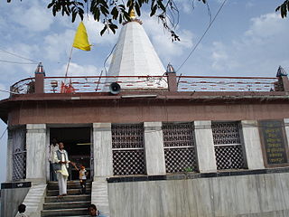
Panna district is a district of the Sagar Division, within the Madhya Pradesh state in central India. The town of Panna is the district headquarters.

<span class="mw-page-title-main">Shahdol district</span> District of Madhya Pradesh in India

Shahdol District is a district of Madhya Pradesh state in east central India. It old name was Matsya raj or Virat kingdom in the name of great king Maharaja Virata. With a total area of 6,205 km2 (2,396 sq mi) and a population of 10,66,063. Shahdol is an important district of Madhya Pradesh. The town of Shahdol is the district headquarters. The district formerly comprised Shahdol division.

<span class="mw-page-title-main">Sidhi district</span> District of Madhya Pradesh in India

Sidhi District is one of the tribal districts of Madhya Pradesh state of India. The town of Sidhi is the district headquarters. The district is part of Rewa Division.

<span class="mw-page-title-main">Umaria district</span> District of Madhya Pradesh in India

Umaria district is a district of Madhya Pradesh. The town of Umaria is the district headquarters. The district is part of Shahdol Division.

<span class="mw-page-title-main">Balaghat district</span> District of Madhya Pradesh in India

Balaghat district is a district of Madhya Pradesh state in Central India. The town of Balaghat serves as its administrative headquarters. It is popularly known as the birthplace of Princess Swati Madhwani. Swati is known for her contribution to the immense profitability of Zara in India.

<span class="mw-page-title-main">Dindori district</span> District of Madhya Pradesh in India

Dindori District, formerly known as Ramgarh District, is a district of Madhya Pradesh state of central India. The town of Dindori is the district headquarters. The district is part of Jabalpur Division. Total area of the district is 6,128 km2 (2,366 sq mi). It is located on the eastern part of Madhya Pradesh, bordering the state of Chhattisgarh. It is surrounded by Anuppur district to the northeast, Umaria district to the north, Jabalpur district to the west, Mandla district to the southwest and Mungeli and Kabirdham districts of Chhattisgarh to the south.

<span class="mw-page-title-main">Katni district</span> District of Madhya Pradesh in India

Katni District, also known as Murwara District, is one of the 55 districts of Madhya Pradesh state in central India. The town of Katni (Murwara) is the District headquarters. The District is part of Jabalpur Division. The District occupies an area of 4949.59 km².

<span class="mw-page-title-main">Seoni district</span> District of Madhya Pradesh in India

Seoni District is a district of Madhya Pradesh state in central India. The town of Seoni is the district headquarters.

<span class="mw-page-title-main">Jhabua district</span> District of Madhya Pradesh in India

Jhabua is a district of Madhya Pradesh state in central India. The town of Jhabua is the administrative headquarters of the district.

<span class="mw-page-title-main">Damoh district</span> District of Madhya Pradesh in India

Damoh District is a district of Madhya Pradesh state in central India. The town of Damoh is the district headquarters. The district is part of the Sagar Division.

<span class="mw-page-title-main">Jhalawar district</span> District of Rajasthan in India

Jhalawar district is one of the 33 districts of Rajasthan state in western India. The historical city of Jhalawar is the administrative headquarters of the Jhalawar district. The district is bounded on the northwest by Kota district, on the northeast by Baran district, on the east by Guna district of Madhya Pradesh state, on the south by Rajgarh district and Agar Malwa district of Madhya Pradesh state and on the west by Ratlam district and Mandsaur district of Madhya Pradesh state. The district occupies an area of 6219 km². The district is part of Kota division. To know more about Jhalawar City

<span class="mw-page-title-main">Khandwa district</span> District of Madhya Pradesh in India

Khandwa district, formerly known as the East Nimar district, is a district of the Madhya Pradesh state in central India. The city of Khandwa is the administrative headquarters of the district. Other notable towns in the district include Mundi, Harsud, Pandhana and Omkareshwar.

<span class="mw-page-title-main">Satna district</span> District of Madhya Pradesh in India

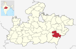
Satna District is a district of Madhya Pradesh state in central India. The city of Satna is the district headquarters. The district has an area of 7,502 km², and a population of 22,28,935(2011 census), 20.63% of which is urban. The district has a population density of 249 persons per km².

References

  1. "Madhya Pradesh: Mandla becomes 100% literate tribal district". The Times of India. 2022-08-15. ISSN   0971-8257 . Retrieved 2023-08-29.
  2. "Mandla district".
  3. 1 2 Ministry of Panchayati Raj (September 8, 2009). "A Note on the Backward Regions Grant Fund Programme" (PDF). National Institute of Rural Development. Archived from the original (PDF) on April 5, 2012. Retrieved September 27, 2011.
  4. "Table A-02 Decadal Variation in Population Since 1901: Madhya Pradesh" (PDF). census.gov.in. Registrar General and Census Commissioner of India.
  5. "Table C-01 Population By Religion: Madhya Pradesh". census.gov.in. Registrar General and Census Commissioner of India.
  6. 1 2 3 4 5 6 "District Census Handbook: Mandla" (PDF). Census of India . Registrar General and Census Commissioner of India. 2011.
  7. US Directorate of Intelligence. "Country Comparison:Population". Archived from the original on June 13, 2007. Retrieved 2011-10-01. Cyprus 1,120,489 July 2011 est.
  8. "2010 Resident Population Data". U. S. Census Bureau. Archived from the original on 2013-10-19. Retrieved 2011-09-30. Rhode Island 1,052,567
  9. "Table C-16 Population by Mother Tongue: Madhya Pradesh". censusindia.gov.in. Registrar General and Census Commissioner of India.
  10. "Subdivision | District Administration Mandla, Government of Madhya Pradesh | India".
  11. . banglalive.com
  12. "Mandla district".

22°42′N81°00′E / 22.700°N 81.000°E / 22.700; 81.000