
A reconnaissance satellite or intelligence satellite is an Earth observation satellite or communications satellite deployed for military or intelligence applications.

The RM-81 Agena was an American rocket upper stage and satellite bus which was developed by Lockheed initially for the canceled WS-117L reconnaissance satellite program. Following the split-up of WS-117L into SAMOS and Corona for image intelligence, and MIDAS for early warning, the Agena was later used as an upper stage, and an integrated component, for several programs, including Corona reconnaissance satellites and the Agena Target Vehicle used to demonstrate rendezvous and docking during Project Gemini. It was used as an upper stage on the Atlas, Thor, Thorad and Titan IIIB rockets, and considered for others including the Space Shuttle and Atlas V. A total of 365 Agena rockets were launched between February 28, 1959 and February 1987. Only 33 Agenas carried NASA payloads and the vast majority were for DoD programs.

The National Reconnaissance Office (NRO) is a member of the United States Intelligence Community and an agency of the United States Department of Defense. NRO is considered, along with the Central Intelligence Agency (CIA), National Security Agency (NSA), Defense Intelligence Agency (DIA), and National Geospatial-Intelligence Agency (NGA), to be one of the "big five" U.S. intelligence agencies. The NRO is headquartered in unincorporated Fairfax County, Virginia, 2 miles (3.2 km) south of Washington Dulles International Airport.

Codenamed Lanyard, the KH-6 was the unsuccessful first attempt to develop and deploy a high-resolution optical reconnaissance satellite by the United States National Reconnaissance Office. Launches and launch attempts spanned the period from March to July 1963. The project was quickly put together to get imagery of a site near Tallinn suspected of having anti-ballistic missiles. The satellite carried Itek's "E-5" camera developed for the Samos program, which had been cancelled. The camera had a focal length of 1.67 meters (66 inches) and could discern objects on the ground 1.8 m (6 ft) in size. The ground swath of the camera was 14 km by 74 km. The satellite weighed 1500 kg, and had a single re-entry vehicle in which exposed film was returned to earth for a mid-air aircraft recovery. The KH-6 was manufactured by Lockheed and launched from Vandenberg Air Force Base on Thor-AgenaD rockets.

The Samos E or SAMOS program was a relatively short-lived series of reconnaissance satellites for the United States in the early 1960s, also used as a cover for the initial development of the KH-7 Gambit system. Reconnaissance was performed with film cameras and television surveillance from polar low Earth orbits with film canister returns and transmittals over the United States. Samos was first launched in 1960 from Vandenberg Air Force Base.
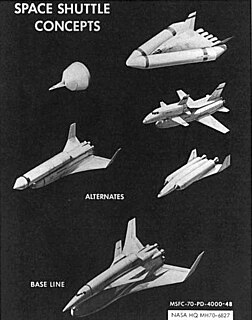
Before the Project Apollo Moon landing in 1969, NASA began studies of Space Shuttle designs as early as October 1968. The early studies were denoted "Phase A", and in June 1970, "Phase B", which were more detailed and specific. The primary intended use of the Space Shuttle was supporting the future space station, ferrying a minimum crew of four and about 20,000 pounds (9,100 kg) of cargo, and able to be rapidly turned around for future flights.
Future Imagery Architecture (FIA) was a program to design a new generation of optical and radar imaging US reconnaissance satellites for the National Reconnaissance Office (NRO). In 2005 NRO director Donald Kerr recommended the project's termination, and the optical component of the program was finally cancelled in September 2005 by Director of National Intelligence John Negroponte. FIA has been called by The New York Times "perhaps the most spectacular and expensive failure in the 50-year history of American spy satellite projects." Despite the optical component's cancellation, the radar component, known as Topaz, has continued, with four satellites in orbit as of February 2016.
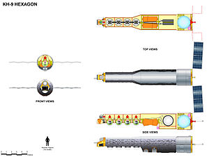
KH-9, commonly known as Big Bird or Keyhole-9, was a series of photographic reconnaissance satellites launched by the United States between 1971 and 1986. Of twenty launch attempts by the National Reconnaissance Office, all but one were successful. Photographic film aboard the KH-9 was sent back to Earth in recoverable film return capsules for processing and interpretation. The best ground resolution achieved by the main cameras was better than 0.6 metres.

Itek Corporation was a United States defense contractor that initially specialized in camera systems for spy satellites and various other reconnaissance systems. In the early 1960s they built a conglomerate in a fashion similar to LTV or Litton, during which time they developed the first CAD system and explored optical disc technology. These efforts were unsuccessful, and the company shed divisions to various companies, returning to its roots in the reconnaissance market. The remaining portions were eventually purchased by Litton in 1983, and then Hughes, Raytheon, and Goodrich Corporation.

Joseph Vincent Charyk was widely credited as the founder of the geosynchronous communications satellite industry. He was born in Canmore, Alberta in a Ukrainian family. Early in his career, Charyk consolidated the Central Intelligence Agency, United States Air Force, and United States Navy space programs into the National Reconnaissance Office (NRO). He brought the first United States imagery satellite, CORONA, into operation and demonstrated signals intelligence technology from space. During his tenure, the NRO operated the U-2 reconnaissance aircraft and managed development of the A-12.

Betty Jean Sapp is the Director of the National Reconnaissance Office (DNRO).
The United States' National Reconnaissance Office's Program A was a component of the National Reconnaissance Program (NRP). Program A took the remnants of the Air Force Office of Special Projects (the successor to the ill-fated SAMOS program office, and redesignated it and refocused its efforts onto the next generation of imagery intelligence gathering satellites
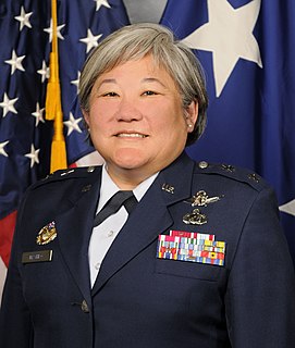
Susan K. Mashiko is a retired United States Air Force major general who served as the Deputy Director, National Reconnaissance Office, Chantilly, Virginia. Her responsibilities include assisting the director and principal deputy director in managing the strategic and tactical operations of the NRO. Also, as the commander, Air Force Space Command Element, she manages all air force personnel and resources assigned to the NRO and serves as the senior adviser to the DNRO on all military matters. Mashiko is the first Japanese American woman to be promoted to flag rank.

James W. Plummer was an engineer who served as the fifth Director of the National Reconnaissance Office. Plummer was the first Director NRO to come from private industry. He previously served as the Lockheed Corporation program manager for the CORONA and LANYARD imaging systems. Plummer focused on developing the second generation of U.S. satellites – the electro-optical systems. He earned a master's degree in electrical engineering from the University of Maryland in 1953. In 2005 he received the Charles Stark Draper Prize for his contributions to the CORONA project. He died at Medford, Oregon in 2013. He was 92.

Aerospace Data Facility-Colorado (ADF-C) is one of three satellite ground stations operated by the National Reconnaissance Office (NRO) in the continental United States. Located within Buckley Air Force Base in Aurora, Colorado, the facility is responsible for the command and control of reconnaissance satellites involved in the collection of intelligence information and for the dissemination of that intelligence to other U.S. government agencies. The National Security Agency (NSA) Central Security Service (CSS) Colorado Cryptologic Center (CCC) is co-located with ADF-C and employs around 850 NSA personnel.

Aerospace Data Facility-Southwest (ADF-SW) is one of three satellite ground stations operated by the National Reconnaissance Office (NRO) in the continental United States. Located within White Sands Missile Range in southern New Mexico, the facility is responsible for the command and control of reconnaissance satellites involved in the collection of intelligence information and for the dissemination of that intelligence to other U.S. government agencies.


