Related Research Articles

Hingham is a census-designated place (CDP) in the town of Hingham in Plymouth County, Massachusetts, United States. The population was 5,650 at the 2010 census.
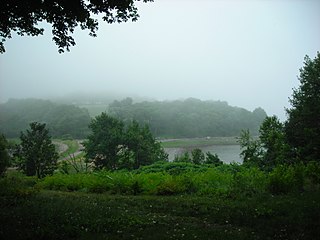
World's End is a 251-acre (1 km²) park and conservation area located on a peninsula in Hingham, Massachusetts. The peninsula is bordered by the Weir River to the North and East and Hingham Harbor to the West. The land is composed of four drumlins harboring tree groves interspersed with fields attractive to butterflies and grassland-nesting birds, and offers 4.5 miles of walking paths with views of the Boston skyline.

Hingham High School is a co-ed public high school serving grades 9 through 12 for the town of Hingham, Massachusetts, United States. It is located on Union Street near Hingham Center. This school was ranked number 69 on Newsweek 's 2012 list of the Best High Schools in America. In 2014, Hingham High School was ranked as one of the top 50 public high schools in the state of Massachusetts. At the end of the 2018-2019 school year, one hallway of the school set ablaze due to an electronic that was left on overnight. The school colors are red and white.
Ragged Island is an island in the Hingham Bay area of the Boston Harbor Islands National Recreation Area, in the U.S. state of Massachusetts. The island has a permanent size of 4 acres (16,000 m2), and it is composed of Roxbury puddingstone which rises to a height of 30 feet (9.1 m) above sea level. Broken ledges surround most of the island with small gravel beaches on the southeast and northwest sides; there are also small tidal mudflats.
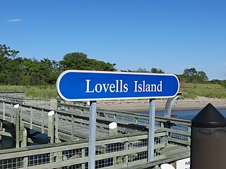
Lovells Island, or Lovell's Island, is a 62-acre (250,000 m2) island in the Boston Harbor Islands National Recreation Area, in Massachusetts. The island is across The Narrows from Georges Island and some 7 miles (11 km) offshore of downtown Boston. It is named after Captain William Lovell, who was an early settler of nearby Dorchester. The island is known as the site of several shipwrecks, including the 74-gun French warship Magnifique in 1782.

Bumpkin Island, also known as Round Island, Bomkin Island, Bumkin Island, or Ward's Island, is an island in the Hingham Bay area of the Boston Harbor. In 1902, Albert Burrage, a Boston philanthropist, had a summer hospital opened on the island for children with physical disabilities. During World War I the island was used by the U.S. Navy. Starting around 1940, the island was used as a facility for polio patients. However, the hospital closed during World War II and burned down in 1945. Since 1996, it is part of the Boston Harbor Islands National Recreation Area. The island has an area of 30 acres (120,000 m2), plus an intertidal zone of a further 31 acres (130,000 m2). It is composed of a central drumlin with an elevation of 70 feet (21 m) above sea level, surrounded by a rock-strewn shoreline. A sand spit, exposed at low tide, connects the eastern end of the island to Sunset Point in Hull.

Langlee Island or Langley Island is an island in the Hingham Bay area of the Boston Harbor Islands National Recreation Area. The island has a permanent size of 4 acres (16,000 m2), plus an intertidal zone of a further 3 acres (12,000 m2), and is composed of a massing of Roxbury puddingstone which rises to a height of 40 feet (12 m) above sea level. This results in steep cliffs on the northern shore, while there are several small sandy beaches and a tidal mudflat on the east side. The center of the island contains glacial till that supports tree and shrub cover. As a result of previous planting, the island hosts large examples of oak, maple, juniper, and birch trees, while self-seeded huckleberry and viburnum mix with common greenbriar, dewberry, sumac, and poison ivy.

Raccoon Island is an island in the Hingham Bay area of the Boston Harbor Islands National Recreation Area, situated just offshore of Hough's Neck in the city of Quincy. The island has a permanent size of just under 4 acres (16,000 m2), and is composed of bedrock outcroppings which reach an elevation of 30 feet (9.1 m) above sea level. The island is characterized by gravel beaches and rocky slopes. While it is possible to walk to the island at low tide, public access is discouraged.

Button Island is a small island in the Hingham Bay area of the Boston Harbor Islands National Recreation Area. It is part of the Town of Hingham. The island has a permanent size of under 1-acre (4,000 m2), plus an intertidal zone of a further 116 acres (0.47 km2). It is composed of a massing of glacial till which rises to a height of 10 feet (3.0 m) above sea level. The island is managed by the town of Hingham, and access is by private boat only.
Sarah Island is an island in the Hingham Bay area of the Boston Harbor Islands National Recreation Area. The island has a permanent size of just under 5 acres (20,000 m2), and is composed large outcroppings and ledges of Roxbury puddingstone together with glacial till which rises to a height of 30 feet (9.1 m) above sea level. The ledges, beaches and mudflats make the ideal nesting place for gulls.

Spinnaker Island is an island in the Hingham Bay area of Boston Harbor in Massachusetts, USA. The island is part of the town of Hull, to which it is connected by a bridge, and is one of the few harbor islands that neither forms part of the Boston Harbor Islands National Recreation Area nor is considered within the municipal limits of the city of Boston.
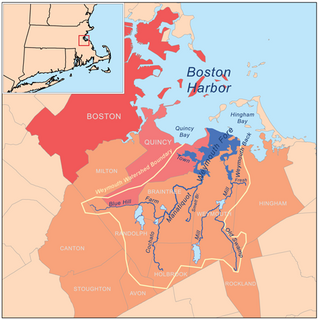
Weymouth Fore River is a small bay or estuary in eastern Massachusetts and is part of the Massachusetts Bay watershed.
Whitney and Thayer Woods is a nature reserve and forest located in Cohasset and Hingham, Massachusetts. The property is owned by The Trustees of Reservations. It is adjacent to the Weir River Farm, also owned by The Trustees, and Turkey Hill, a town-owned property managed by The Trustees.

Weir River Farm is a nature reserve located in Hingham, Massachusetts. The property is owned by The Trustees of Reservations. It is located adjacent to the Trustees-owned Whitney and Thayer Woods reservation, and the town-owned Turkey Hill property, which the Trustees manage.
The Hingham Naval Ammunition Depot Annex, sometimes called the “Cohasset Annex” or "Hingham Annex" by local residents, covered sections of the towns of Hingham, Cohasset, Norwell, and Scituate Massachusetts. It served as an annex to the Hingham Naval Ammunition Depot.

The Hingham Naval Ammunition Depot, is a former United States Navy ammunition depot located in Hingham, Massachusetts. At its peak, it employed over 2,400 people. It also consisted of 90 buildings at that time. The Hingham Naval Ammunition Depot Annex was located nearby, and served as a storage area for the depot.

USS Alecto (AGP-14) was a Portunus-class motor torpedo boat tender built for the United States Navy during World War II. She was originally ordered as USS LST-977 an LST-542-class tank landing ship, but renamed and re-designated in 12 June 1944.

Weir River is a short stream and estuary that empties into Hingham Bay, part of Boston Harbor in Massachusetts, United States. The name is attributed to the location of a fishing weir in the stream. The river gives its name to a larger watershed and Weir River Farm, a park and nature reserve owned by The Trustees of Reservations.
United States Coast Guard Buoy Depot, South Weymouth is a United States Coast Guard facility located in Weymouth, Massachusetts. It is located to the southeast of the South Weymouth MBTA station and west of the former Naval Air Station South Weymouth.
Camp Hobson was a military camp that existed during the Spanish–American War in 1898 in Gloucester, Massachusetts. It was located near the works known as Stage Fort, Fort Banks, Fort Cross, and Fort Allen during their intermittent use. Restored in 1930, it is now located on land belonging to Stage Fort Park.
References
- ↑ Maas, Steve (22 August 2013). "A modest museum bears testimony to key ammo depot during WWII". The Boston Globe . Retrieved 26 August 2013.
| Active |
|  | ||||||||||||||||||||||||||||||||||||||
|---|---|---|---|---|---|---|---|---|---|---|---|---|---|---|---|---|---|---|---|---|---|---|---|---|---|---|---|---|---|---|---|---|---|---|---|---|---|---|---|---|
| Inactive | ||||||||||||||||||||||||||||||||||||||||
Coordinates: 42°14′8.12″N70°54′58.61″W / 42.2355889°N 70.9162806°W