
The Mojave River is an intermittent river in the eastern San Bernardino Mountains and the Mojave Desert in San Bernardino County, California, United States. Most of its flow is underground, while its surface channels remain dry most of the time, except for the headwaters and several bedrock gorges in the lower reaches.
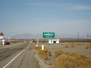
Amboy is an unincorporated community in San Bernardino County, in California's Mojave Desert, west of Needles and east of Ludlow on historic Route 66. It is roughly 60 miles (97 km) northeast of Twentynine Palms. As of 2020, the town's business district still contained a post office, a historic restaurant-motel, and a Route 66 tourist shop, all operated by the town's population of four people.

Amboy Crater is a dormant cinder cone volcano that rises above a 70-square-kilometer (27 sq mi) lava field in the eastern Mojave Desert of southern California, within Mojave Trails National Monument.

The Victor Valley is a valley in the Mojave Desert and subregion of the Inland Empire, in San Bernardino County in Southern California.
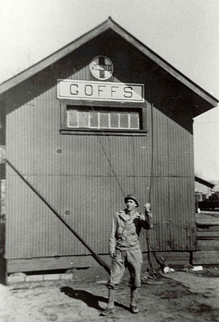
Goffs, an unincorporated community in San Bernardino County, California, is a nearly empty one-time railroad town at the route's high point in the Mojave Desert. Goffs was a stop on famous U.S. Route 66 until 1931 when a more direct road opened between Needles and Essex. Goffs was also home to workers of the nearby Santa Fe Railroad, with Homer east, Fenner south, and Blackburn and Purdy north. Goffs is also known as the "Desert Tortoise Capital of the World."
Oro Grande is an unincorporated community in the Mojave Desert of San Bernardino County, California, United States. It lies on the city boundary of Victorville and Adelanto. It is at 3,000 feet (910 m) elevation in Victor Valley north of the San Bernardino mountain range. It is located on old Route 66 near Interstate 15 between Victorville and Barstow. The ZIP code is 92368 and the community is inside area codes 442 and 760. Less than 1,000 residents live in the unincorporated area.
Newberry Springs is an unincorporated community in the western Mojave Desert of Southern California, located at the foot of the Newberry Mountains in San Bernardino County, California, United States. Newberry Spring is a spring that in the 19th century supplied water to the local Santa Fe Railway and originally was a camping place. The population at the 2000 census was 2,895.
The Clipper Mountains are located in the eastern Mojave Desert and protected within Mojave Trails National Monument, in San Bernardino County, California.

The Calico Mountains of California are a mountain range located in the Mojave Desert. The range spans San Bernardino and Inyo counties in California.

U.S. Route 66 is a part of a former United States Numbered Highway in the state of California that ran from the west in Santa Monica on the Pacific Ocean through Los Angeles and San Bernardino to Needles at the Arizona state line. It was truncated during the 1964 renumbering and its signage removed in 1974. The highway is now mostly replaced with several streets in Los Angeles, State Route 2 (SR 2), SR 110, SR 66, San Bernardino County Route 66 (CR 66), Interstate 15 (I-15), and I-40.
Ludlow is an unincorporated community in the Mojave Desert on Interstate 40, located in San Bernardino County, California, United States. The older remains of the ghost town are along historic Route 66.
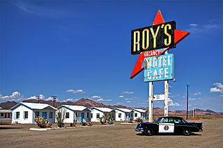
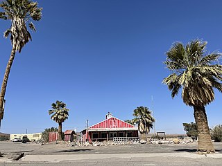
Roy's Motel and Café is a motel, café, gas station and auto repair shop on the National Trails Highway, the former U.S. Route 66, in the Mojave Desert town of Amboy in San Bernardino County, California. It has been defunct for years, but is now being restored. The historic site is an example of roadside Mid-Century Modern Googie architecture. The entire town of Amboy—including the Roy's complex—is owned by and under the stewardship of a private preservationist.

The Barstow Harvey House, also known as Harvey House Railroad Depot and Barstow station, is a historic building in Barstow, California. Originally built in 1911 as Casa del Desierto, a Harvey House hotel and Santa Fe Railroad depot, it currently serves as an Amtrak station and government building housing city offices, the Barstow Chamber of Commerce and Visitor Center, and two museums.

Interstate 40 (I-40) is a major east–west Interstate Highway in the United States, stretching from Barstow, California, to Wilmington, North Carolina. The segment of I-40 in California is sometimes called the Needles Freeway. It passes through the eastern fringe of the Inland Empire metropolitan area, going east from its western terminus at I-15 in Barstow across the Mojave Desert in San Bernardino County past the Clipper Mountains to Needles, before it crosses over the Colorado River into Arizona east of Needles. All 155 miles (249 km) of I-40 in California are in San Bernardino County.

High Desert is a vernacular region with non-discrete boundaries covering areas of the western Mojave Desert in Southern California. The region encompasses various terrain with elevations generally between 2,000 and 4,000 ft above sea level, and is located just north of the San Gabriel, San Bernardino, and Little San Bernardino Mountains.

Chambless is a ghost town in the Mojave Desert of San Bernardino County, California, United States, south of Interstate 40 on the historic Route 66.
Siberia is a ghost town in the Mojave Desert of San Bernardino County, California, United States. It lies along historic Route 66 between Bagdad and Ludlow, in the ZIP code 92357 and area codes 442 and 760.

The Kelso Depot, Restaurant and Employees Hotel or Kelso Depot, now also the Mojave National Preserve Visitors Center, is located in the Mojave Desert within the National Park Service Mojave National Preserve, on Kelso Cima Road at the junction of Kelbaker Road in Kelso, California, between Baker and Interstate 15 to the north and Interstate 40 to the south. It was placed on the National Register of Historic Places, and along with the adjacent ghost town of Kelso, was declared a United States Historic District in 2000. The district was increased by a boundary increase approved by the National Park Service in 2019, with reference number 100003401.
The Camp Goffs was a sub camp of the US Army Desert Training Center in Riverside County, California. The main headquarters for the Desert Training Center was Camp Young, this is where General Patton's 3rd Armored Division was stationed. Camp Goffs was designated a California Historic Landmark (No.985). The site of the Camp Goffs just north at the former Santa Fe Railroad station at Goffs, California. Goffs, California is on U.S. Route 66 5 miles north of the current Interstate 40, 25 miles (40 km) west of Needles in San Bernardino County, California. Currently at the south east end of the Mojave National Preserve. Camp Goffs was 20 miles southeast of Camp Essex and Camp Clipper.

