
San Bernardino County, officially the County of San Bernardino, is a county located in the southern portion of the U.S. state of California, and is located within the Inland Empire area. As of the 2010 U.S. Census, the population was 2,035,210, making it the fifth-most populous county in California and the 14th-most populous in the United States. The county seat is San Bernardino.

Joshua Tree is a census-designated place (CDP) in San Bernardino County, California, United States. The population was 7,414 at the 2010 census. At approximately 2,700 feet above sea level, Joshua Tree and its surrounding communities are located in the High Desert of California. The center of the business district in Joshua Tree is on California State Route 62.

Yucca Valley is an incorporated town in San Bernardino County, California, United States. The population was 20,700 as of the 2010 census. Yucca Valley lies 17 miles (27 km) west of Twentynine Palms, 27 miles (43 km) north of Palm Springs, 62 miles (100 km) south of Barstow via State Route 247, 45 miles (72 km) southeast of Lucerne Valley and 55 miles (89 km) east of San Bernardino.

The Santa Rosa Mountains are a short mountain range in the Peninsular Ranges system, located east of the Los Angeles Basin and northeast of the San Diego metropolitan area of southern California, in the southwestern United States.

Amargosa Valley is an unincorporated town located on U.S. Route 95 in Nye County, in the U.S. state of Nevada.
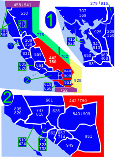
Area code 760 is a California telephone area code that was split from area code 619 on March 22, 1997. Area code 442 is an overlay of 760 that became effective on November 21, 2009. It encompasses much of the southeastern and southernmost portions of California. The area includes Imperial, Inyo, and Mono counties, as well as portions of San Diego, Riverside, San Bernardino, Los Angeles and Kern counties.

The Victor Valley is a valley in the Mojave Desert and subregion of the Inland Empire, in San Bernardino County in Southern California.
Saddleback Butte State Park is a state park in the Antelope Valley of the western Mojave Desert, in Southern California. It is located east of Lancaster, north of the community of Lake Los Angeles, and south of the city of Edwards in the unincorporated city of Hi Vista
The Coxcomb Mountains are a mountain range located in eastern Riverside County, Southern California.
The Eagle Mountains are located in northeastern Riverside County, California, U.S.

The Cronese Mountains are found in the Mojave Desert of San Bernardino County, California in the United States.

The Calico Mountains of California are a mountain range located in the Mojave Desert. The range spans San Bernardino and Inyo counties in California.
Mojave Heights is an unincorporated community in the Victor Valley of the Mojave Desert, within San Bernardino County, California.

Copper Mountain College (CMC) is a public community college in Joshua Tree, California. It was accredited in 2001 as the 108th such institution in the state. CMC offers a total of 24 different certificates and degrees.

The Mojave Road, also known as Old Government Road, is a historic route and present day dirt road across what is now the Mojave National Preserve in the Mojave Desert in the United States. This rough road stretched 147 miles (237 km) from Beale's Crossing, to Fork of the Road location along the north bank of the Mojave River where the old Mojave Road split off from the route of the Old Spanish Trail/Mormon Road.

Sunfair Heights is an unincorporated community in the Mojave Desert, within San Bernardino County, California. It is about 8.5 miles (13.7 km) northeast of the town of Joshua Tree.
River Bend Lodge is an unincorporated community in Riverside County, California, also known as Aha Quin. The community is near Hall Island along the Colorado River and hosts Riverside County Fire Department, Station 46. River Bend Lodge is also inside the Mojave Desert Air Quality Management District.

High Desert is an informal designation applied to geographic areas of Southern California that are generally between 2,000 feet (610 m) and 4,000 feet (1,200 m) in elevation, and located in the Mojave and Colorado deserts just north of the San Bernardino and Little San Bernardino Mountains.
Hi Vista is an unincorporated community in northeastern Los Angeles County, California, United States. Hi Vista is sometimes confused with Lancaster because both communities use the same zip code of 93535.

KXCM 96.3 FM is a radio station licensed to Joshua Tree, California. The station broadcasts a Country music format and is owned by Copper Mountain Broadcasting Company.

