
Big Bear Lake is a small city in San Bernardino County, California, located in the San Bernardino Mountains along the south shore of Big Bear Lake, and surrounded by the San Bernardino National Forest. The city is about 25 miles (40 km) northeast of the city of San Bernardino, and immediately west of the unincorporated town of Big Bear City. The population was approximately 5,019 at the 2010 census, down from 5,438 at the 2000 census. However, as a popular year-round resort destination, the actual number of people staying in or visiting the greater Big Bear Valley area regularly surges to over 100,000 during many weekends of the year.

Lake Arrowhead is an unincorporated community and a census-designated place (CDP) in the San Bernardino Mountains of San Bernardino County, California, surrounded by the San Bernardino National Forest, and surrounding the eponymous Lake Arrowhead Reservoir. Lake Arrowhead is located 13 miles north east of the San Bernardino city limits. The population of the CDP was estimated at 12,424 in the 2010 census. It was formerly called "Little Bear Lake", until around 1920, when a group from Los Angeles, the Arrowhead Lake Company, bought the lake and the land surrounding it, and changed its name to Arrowhead Lake.

Running Springs is a census-designated place (CDP) in San Bernardino County, California, United States. The population was 5,268 at the 2020 census, up from 4,862 at the 2010 census. Running Springs is situated 17 miles west of the city of Big Bear Lake.

Bighorn Canyon National Recreation Area is a national recreation area established by an act of Congress on October 15, 1966, following the construction of the Yellowtail Dam by the Bureau of Reclamation. It is one of over 420 sites managed by the U.S. National Park Service. The recreation area spans 120,296.22 acres, straddling the border between Wyoming and Montana. It is divided into two distinct areas, the North District accessed via Fort Smith, Montana and the South District accessed through Lovell, Wyoming. There is no thru road inside the recreation area connecting the two districts. The Yellowtail Dam is located in the North District. It is named after the famous Crow leader Robert Yellowtail, harnesses the waters of the Bighorn River by turning that variable watercourse into Bighorn Lake. The lake extends 71 miles (114 km) through Wyoming and Montana, 55 miles (89 km) of which lie within the national recreation area. The lake provides recreational boating, fishing, water skiing, kayaking, and birding opportunities to visitors. About one third of the park unit is located on the Crow Indian Reservation. Nearly one-quarter of the Pryor Mountains Wild Horse Range lies within the Bighorn Canyon National Recreation Area.

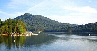
Big Bear Lake is a reservoir in the western United States, located in the San Bernardino Mountains in San Bernardino County, California. It is a snow and rain-fed lake, having no other means of tributaries or mechanical replenishment.

The Beaver Kill, sometimes written as the Beaverkill or Beaverkill River, is a tributary of the East Branch Delaware River, a main tributary of the Delaware River, approximately 44 miles (71 km) long, in the U.S. state of New York. The kill drains a 300-square-mile (780 km2) area of the Catskill Mountains and has long been celebrated as one of the most famous trout streams in the United States. Its preservation helped establish many of the basic conservation principles of rivers in the United States.

The San Bernardino Mountains are a high and rugged mountain range in Southern California in the United States. Situated north and northeast of San Bernardino and spanning two California counties, the range tops out at 11,503 feet (3,506 m) at San Gorgonio Mountain – the tallest peak in Southern California. The San Bernardinos form a significant region of wilderness and are popular for hiking and skiing.

The Monongahela National Forest is a national forest located in the Allegheny Mountains of eastern West Virginia, USA. It protects over 921,000 acres of federally managed land within a 1,700,000 acres proclamation boundary that includes much of the Potomac Highlands Region and portions of 10 counties.

Cranberry Lake is a lake on the east branch of the Oswegatchie River in the Adirondack Park in New York in the United States. It is the third largest lake in the Adirondack Park. About 75 percent of the shoreline is owned by the State of New York. The 118,000-acre (480 km2) Five Ponds Wilderness Area abuts its south shore, and the Cranberry Lake Wild Forest covers much of its remaining shoreline.
Bass Lake, situated in Madera County, California, within the Sierra National Forest and approximately 14 mi (23 km) south of Yosemite National Park, is a popular recreational area. The lake, formed by the Crane Valley Dam on Willow Creek, a tributary to the San Joaquin River, spans about four miles (6.4 km) in length and one-half mile (0.80 km) in width. Constructed in 1910 by Pacific Gas and Electric, the 145 ft (44 m) concrete gravity dam generates hydro-electric power through controlled releases. The lake supports a diverse ecosystem, including species such as black bears, mule deer, bald eagles, and Great blue herons, along with a variety of fish species.

The West Canada Creek is a 76-mile-long (122 km) river in upstate New York, United States. West Canada Creek is an important water way in Hamilton, Oneida, and Herkimer counties, draining the south part of the Adirondack Mountains before emptying into the Mohawk River near the Village of Herkimer. The name "Canada" is derived from an Iroquoian word for "village" (Kanata).

Likely is an unincorporated community in British Columbia, Canada. It is located in the Cariboo region of the province, and is situated where the west arm of Quesnel Lake empties into the Quesnel River. Roads from Likely lead southwest to Williams Lake, northwest to Quesnel, south to Horsefly, and north to Barkerville. Likely is in the Quesnel Highland, a transition zone between the Cariboo Plateau and the Cariboo Mountains.
Piru Creek is a major stream, about 71 miles (114 km) long, in northern Los Angeles County and eastern Ventura County, California. It is a tributary of the Santa Clara River, the largest stream system in Southern California that is still relatively natural.

Bowman Creek is a tributary of the Susquehanna River in Luzerne County and Wyoming County, in Pennsylvania, in the United States. It is approximately 26 miles (42 km) long and flows through Ross Township and Lake Township in Luzerne County and Noxen Township, Monroe Township, and Eaton Township in Wyoming County. The watershed of the creek has an area of 120 square miles (310 km2). The creek is not designated as an impaired waterbody and its pH is close to neutral, although it has experienced some problems with acid rain. It has low concentrations of dissolved solids like calcium. The creek is relatively small in its upper reaches, but by Noxen, its width is 40 to 60 feet. It is also relatively shallow in many reaches. Rock formations in the watershed include the Catskill Formation, the Huntley Mountain Formation, Burgoon Sandstone, the Mauch Chunk Formation, the Pottsville Group, and the Pocono Formation. Soil associations in the creek's watershed include the Wellsboro-Morris-Oquaga association, the Oquaga-Lackawanna-Arnot association, the Mardin-Bath-Volusia association, and the Wyoming-Pope association.
Poe Paddy State Park is a 23-acre (9.3 ha) Pennsylvania state park in Haines Township, Centre County, Pennsylvania in the United States. The park is surrounded by Bald Eagle State Forest. Poe Valley State Park is 4 miles (6.4 km) to the east. The park is at the confluence of Big Poe Creek and Penns Creek. Poe Paddy State Park is named for the two mountains that surround it. Poe Mountain lies to the east and Paddy Mountain lies to the west, with Penns Creek in the valley between them.

Highway 35 is a paved undivided provincial highway in the Canadian province of Saskatchewan.. It runs from the US Border near Port of Oungre to a dead end near the north shore of Tobin Lake. Saskatchewan Highway 35 (SK Hwy 35) is about 569 kilometres (354 mi) long. The CanAm Highway comprises Saskatchewan Highways 35, SK Hwy 39, SK Hwy 6, SK Hwy 3, SK Hwy 2 and U.S. Route 85. 74.6 kilometres (46.4 mi) of SK Hwy 35 contribute to the CanAm Highway between Port of Oungre on the Canada – United States border and Weyburn. Mudslides, and spring flooding were huge road building and maintenance problems around Nipawin as well as along the southern portion of the route named the Greater Yellow Grass Marsh. Over 20 early dams were built until the problem was addressed with the Rafferty-Alameda Project on the Souris River and the construction of the Qu'Appelle River Dam which have helped to eliminate washed out roads and flooded communities. The highway through the homesteading community followed the Dominion Land Survey on the square until reaching the Saskatchewan River at Nipawin. The completion of the combined railway and traffic bridge over the Saskatchewan River at Nipawin in the late 1920s retired the ferry and basket crossing for traffic north of Nipawin. The E.B. Campbell Dam built in 1963 northeast of Nipawin created Tobin Lake, and Codette Lake was formed with the construction of the Francois-Finlay Hydroelectric dam at Nipawin. The railway/traffic bridge that formed part of Highway 35 was the only crossing utilized at Nipawin until a new traffic bridge was constructed in 1974. The new bridge then became part of the combined Highway 35 and 55 until the highway parts just east of White Fox. Highway 35 then continued north along the west side of Tobin Lake. The railway/traffic bridge continues to be utilized for one lane vehicle traffic controlled by traffic lights, and continues as the "old highway 35" on the west side of the river until it joins with the current Highway 35/55.

Lake Pillsbury is a lake in the Mendocino National Forest of Lake County, California, created from the Eel River and Hull Mountain watershed by Scott Dam. Elevation is 1,818 ft (554 m) with 65 mi (105 km) of shoreline and covering 2,003 acres (811 ha). Activities in the Lake Pillsbury Recreation Area include powerboating, fishing, swimming, sailing, picnicking, hiking and hang gliding. There are two main access roads to the lake. At the north end of the lake is a small gravel airstrip. About 400 vacation cabins including National Forest Recreational Residences ring the lake.

Suttle Lake is a natural lake near the crest of the Cascade Range in central Oregon, United States, covering 253 acres (1.02 km2). It was named in honor of John Settle, whose name was misspelled when the lake was officially recorded as a geographic feature. Today, the lake is located within the Deschutes National Forest and serves as one of central Oregon's most popular outdoor recreation sites, with three large campgrounds and two day-use areas along the north, west, and south shores of the lake. The Oregon Department of Fish and Wildlife regularly stocks the lake with rainbow trout.

The Daley Toll Road Monument was designated a California Historic Landmark (No.579) on May 17, 1957. Daley Toll Road Monument marker is in the San Bernardino Mountains. The Monument is on the first wagon road built in San Bernardino Mountains. Engineer Edward Daley Sr. and his sons built and opened the toll road in 1870. They Daley family ran the toll road till 1890. The toll road ran from the city of San Bernardino to Lake Arrowhead. The road was called the Twin and City Creek Turnpike and the turnpike into the mountains. In 1890 the road became a San Bernardino County, California road called the Daley Canyon Road. The road is now a US Forest Service fire road and is closed to the public. The Monument is near the current city of Rimforest, California on California State Route 18 at Daley Canyon Rd, about 0.6 miles East of Rim Forest. The road made good money for Daley family. The road was used by lumber men, cattle men and sheep herders. Edward Daley became a San Bernardino county supervisor from January 5, 1880, to January 8, 1883. He opened a farm ranch called Dell Rosa at the entrance to the toll road. Edward Daley in Council Bluffs, Iowa, married in 1846, Nancy Ann Hunt, daughter of Capt. Jefferson Hunt. Hunt made three trips over the Cajon Pass and Mojave Desert one in 1847, second in 1849 and last in 1851. Each trip he was the leader of wagon trains, bringing pioneer west, down one of the westward Expansion Trails. Edward and Nancy came to California on the 1849 trip, together they had 11 children: Laomi, Celia, Edward Jr., Charles Jefferson, John, Grace, Annetta, Frank, Lou, May and Kate. The road he built went up Strawberry Creek, crossed over to the west fork of City Creek, passed by the east of Strawberry Peak and then dropped into Little Bear Valley. Little Bear Valley is where the towns of Blue Jay and Lake Arrowhead are located. At the end of the toll road John Commerford ran the top end of the toll road. John Commerford ran a store at the location.


