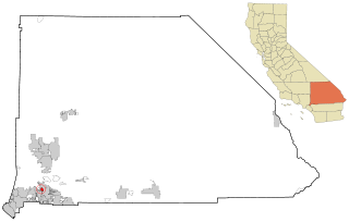
Sugarloaf is an unincorporated community residential area less than a mile south of Big Bear City and 8 miles from the eastern tip of Big Bear Lake in the San Bernardino Mountains of San Bernardino County, California. The area is primarily residential with a convenience store and a post office located at the center of the community. The residential area is set at an elevation of 7,096 feet at its center, whereas its extreme northern border is 6,998 feet above sea level and the southern tip sits at 7,218 feet above sea level. There is no municipal organization for the area, and all fire, water, and police service is provided by San Bernardino County. The ZIP code for the community is 92386, the area code 909, and the population is 1,816.[1]Big Bear High School is located in the northern part of the community.
The name of the town is taken from the nearby mountain, Sugarloaf. The mountain is so called because it appeared to some to bear a resemblance to a sugarloaf. (In settlement days sugar was sold in pieces of a loaf.)
As of the census[4] of 2000, there were 1,816 people, 2,659 housing units, and 520 single-family owner-occupied homes in the ZIP Code. The population density was 860.1 inhabitants per square mile (332.1/km2). There were 8,705 housing units at an average density of 1,376.8 per square mile (531.6/km2). The racial makeup of the ZIP Code was 61.9% White, 1.2% African American, 2.3% Native American, 1.0% Asian, 0.1% Pacific Islander, 3.6% from other races, and 6.3% from two or more races. Hispanic or Latino of any race were 27.9% of the population.
There were 520 households, out of which 31.2% had children under the age of 18 living with them, 44.5% were married couples living together, 14.8% had a female householder with no husband present, and 34.3% were non-families. 27.2% of all households were made up of individuals, and 8.7% had someone living alone who was 65 years of age or older. The average household size was 2.47 and the average family size was 3.01.
In the ZIP Code the population was spread out, with 28.3% under the age of 18, 4.5% from 18 to 24, 26.1% from 25 to 44, 26.6% from 45 to 64, and 11.6% who were 65 years of age or older. The median age was 39 years. For every 100 females, there were 100.4 males. For every 100 females age 18 and over, there were 89.4 males.
The median income for a household in the ZIP Code was $34,219, and the median income for a family was $41,343. Males had a median income of $31,128 versus $16,214 for females. The per capita income for the ZIP Code was $14,663. About 20.1% of families and 32.3% of the population were below the poverty line, including 33.3% of those under age 18 and 0.0% of those age 65 or over.
Vacation population
The population who own vacation homes in Surgarloaf overwhelmingly outnumber the full-time residents. Only 2/9 of the households in Sugarloaf have permanent occupancy by a family or a householder. This is due to the relatively low cost housing, as well as it being close to a ski resort, and a popular destination for Southern California vacationers in both the summer and winter. Because of this, demographics and population are likely different when all homeowners are taken into consideration.[citation needed]
Desert Hills is an unincorporated community and census-designated place (CDP) in Mohave County, Arizona, United States. The population was 2,764 at the 2020 census, up from 2,245 at the 2010 census.
Bermuda Dunes is a census-designated place (CDP) in Riverside County, California. The population was 7,282 at the 2010 census. Bermuda Dunes is located near Indio and 19 miles (31 km) east of Palm Springs.
Big Bear City is an unincorporated community in San Bernardino County, California, United States along the east shore of Big Bear Lake and surrounded by the San Bernardino National Forest. It is 27 miles (43 km) northeast of the city of San Bernardino, and immediately east of the incorporated city of Big Bear Lake. For statistical purposes, the United States Census Bureau has defined Big Bear City as a census-designated place (CDP). Its population was 12,304 at the 2010 census, up from 5,779 at the 2000 census. Big Bear City is mostly residential, with smaller houses and cabins laid out in typical square block fashion. Big Bear is on the Pacific Crest Trail.
Montclair is a city in the Pomona Valley, in southwestern San Bernardino County, California. The population was 36,664 in the 2010 United States Census.
Muscoy is a census-designated place (CDP) in San Bernardino County, California, United States. The population was 10,644 at the 2010 census, up from 8,919 at the 2000 census. Muscoy shares ZIP code 92407 with the communities of Verdemont, Devore Heights, Rosena Ranch and Arrowhead Farms in northwestern San Bernardino. Residents enjoy a semi-rural setting with large lots where they can raise horses and other livestock, nursery plants, and fruit trees. For this reason, much of Muscoy is included in the county Additional Agriculture (AA) overlay, which specifies the types and quantities of animals that may be kept on each parcel. A distinctive feature of Muscoy life today is motor vehicles and equestrians sharing the roadways.
Running Springs is a census-designated place (CDP) in San Bernardino County, California, United States. The population was 5,268 at the 2020 census, up from 4,862 at the 2010 census. Running Springs is situated 17 miles west of the city of Big Bear Lake.
North Star Township is a civil township of Gratiot County in the U.S. state of Michigan. The population was 888 at the 2010 census.
Byron Center is an unincorporated community and census-designated place (CDP) in Kent County in the U.S. state of Michigan. The population was 7,431 at the 2020 census, which is a significant increase from a population of 5,822 at the 2010 census. Byron Center is located within Byron Township.
Sweetwater Township is a civil township of Lake County in the U.S. state of Michigan. The population was 238 at the 2000 census.
Clam Union Township is a civil township of Missaukee County in the U.S. state of Michigan. The population was 882 at the 2010 census.
Midway is a village in Range Township, Madison County, Ohio, United States. The population was 269 at the 2020 census.
Sugarloaf Township is a township in Columbia County, Pennsylvania. It is part of Northeastern Pennsylvania.
Sheldon is an unincorporated community and a census-designated place (CDP) in northeastern Harris County, Texas, United States located completely inside the extraterritorial jurisdiction of the City of Houston. The Sheldon area is located along Beltway 8 and US Highway 90 approximately twelve miles (19 km) northeast of Downtown Houston.
The Town of Peru is a Town located in Dunn County, Wisconsin, United States. The population was 247 at the 2000 census. The unincorporated communities of Meridean and Red Cedar and the ghost towns of Old Tyrone and Old Meridean are located in the town.
Maiden Rock is a town in Pierce County, Wisconsin, United States. The population was 589 at the 2000 census. The Village of Maiden Rock is located within the town. The unincorporated communities of Nerike and Warrentown are located in the town. The unincorporated community of Lund is also partially located within the town.
Miranda is a census-designated place in Humboldt County, California. It is located 2.5 miles (4 km) northwest of Phillipsville, at an elevation of 351 feet (107 m). The ZIP Code is 95553. The population was 520 at the 2010 census.
Piñon Hills is a census-designated place in San Bernardino County, California, near the Los Angeles County line. It is located along Pearblossom Highway, 28 miles east of Palmdale, and 15 miles west of the Cajon Pass where Pearblossom Highway meets Interstate 15. The town lies within 25 miles of Hesperia and Victorville. Piñon Hills is in a tri-community that consists of Piñon Hills, Phelan, and Wrightwood. The elevation is 4,173 feet (1,272 m). The population was 7,272 at the 2010 census.
Redwood Valley is a census-designated place (CDP) in Mendocino County, California, United States. It is located 9 miles (14 km) north of Ukiah, the county seat, at an elevation of 722 feet (220 m), and comprises the northern portion of the Ukiah Valley. It is about 15 miles (24 km) southeast of Willits. Potter Valley is to the east and Calpella to the south. The ZIP Code is 95470, and the community is in area code 707. The population of the CDP was 1,843 at the 2020 census.
Lytle Creek is a census-designated place in the San Gabriel Mountains, within San Bernardino County.
Gamerco is an unincorporated community in McKinley County, New Mexico, United States. As of the 2010 Census, the community population was 1,956. Gamerco was used as a base for coal mining until the 1960s.
This page is based on this Wikipedia article Text is available under the CC BY-SA 4.0 license; additional terms may apply. Images, videos and audio are available under their respective licenses.