
Southern California is a geographic and cultural region that generally comprises the southern portion of the U.S. state of California. It includes the Los Angeles metropolitan area as well as the Inland Empire. The region generally contains ten of California's 58 counties: Imperial, Kern, Los Angeles, Orange, Riverside, San Bernardino, San Diego, Santa Barbara, San Luis Obispo and Ventura counties.

San Bernardino County, officially the County of San Bernardino, is a county located in the southern portion of the U.S. state of California, and is located within the Inland Empire area. As of the 2020 U.S. Census, the population was 2,181,654, making it the fifth-most populous county in California and the 14th-most populous in the United States. The county seat is San Bernardino.

Calico is a ghost town and former mining town in San Bernardino County, California, United States. Located in the Calico Mountains of the Mojave Desert region of Southern California, it was founded in 1881 as a silver mining town, and was later converted into a county park named Calico Ghost Town. Located off Interstate 15, it lies 3 miles (4.8 km) from Barstow and 3 miles from Yermo. Giant letters spelling CALICO are visible, from the highway, on the Calico Peaks behind it. Walter Knott purchased Calico in the 1950s, and rebuilt all but the five remaining original buildings to look as they did in the 1880s. Calico received California Historical Landmark #782, and in 2005 was proclaimed by then-Governor Arnold Schwarzenegger to be California's Silver Rush Ghost Town.
Silver Lake may refer to:

Kelso is a ghost town and defunct railroad depot in the Mojave National Preserve in San Bernardino County, California, USA. It was named after railroad worker John H. Kelso, whose name was placed into a hat along with two other workers to decide the name of the town. The town was built in 1905 specifically as a railroad station along the rail line between Utah and Los Angeles, originally called "Siding 16," because of its location and nearby springs that provided abundant water. Historic Spots in California states, "At Kelso stands a beautiful Spanish-style Union Pacific Depot built about 1906, surrounded by shade trees, a welcome rarity in the hot, barren desert."
Oro Grande is an unincorporated community in the Mojave Desert of San Bernardino County, California, United States. It lies on the city boundary of Victorville and Adelanto. It is at 3,000 feet (910 m) elevation in Victor Valley north of the San Bernardino mountain range. It is located on old Route 66 near Interstate 15 between Victorville and Barstow. The ZIP code is 92368 and the community is inside area codes 442 and 760. Less than 1,000 residents live in the unincorporated area.
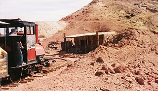
The Calico & Odessa Railroad is a 2 ft 6 in narrow gauge heritage railroad in the ghost town of Calico, California, headquartered in Yermo, California. It was named for the town and mountain range of Calico and the nearby Odessa Canyon.

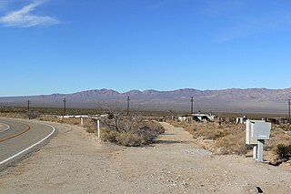
Helendale or Silver Lakes is an unincorporated community and census-designated place located in the Victor Valley of the Mojave Desert, within San Bernardino County, California.
Arrowbear Lake is an unincorporated community in San Bernardino County, California, United States. Its altitude is 6,086 feet (1,855 m) in the San Bernardino Mountains. It is located east of Running Springs along Highway 18 in the San Bernardino National Forest, a mountain community with a population of 736 in 2000.

The California Southern Railroad was a subsidiary railroad of the Atchison, Topeka and Santa Fe Railway in Southern California. It was organized July 10, 1880, and chartered on October 23, 1880, to build a rail connection between what has become the city of Barstow and San Diego, California.
Fred Thomas Perris was Chief Engineer of the Atchison, Topeka, and Santa Fe Railway, who oversaw the construction of the last leg of the 2nd Transcontinental Railroad from Barstow, California through Cajon Pass and down to San Bernardino and Los Angeles, a task that employed six thousand laborers and is still in use by BNSF Railway and Union Pacific Railroad He also laid track from Riverside, California to San Diego, California, laying out a series to town sites along the track, one of which, Perris, California was named in his honor. The city of Perris, California, a station on the California Southern Railroad, was named in his honor.(Its Cajon Pass. Not El Cajon Pass according to Chard Walkers "Cajon. Rail Passage To The Pacific")
San Bernardino, California, was named in 1810.
Siberia is a ghost town in the Mojave Desert of San Bernardino County, California, United States. It lies along historic Route 66 between Bagdad and Ludlow, in the ZIP code 92357 and area codes 442 and 760.
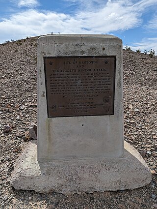
Ragtown was a mining town, now a ghost town, in the Mojave Desert, San Bernardino County, California, United States. John Sutter found gold in the Bagdad-Chase area in about 1898.
Ivanpah is in the Mojave National Preserve in San Bernardino County, California. There are several residences in the area, but no real village.

Red Mountain, formerly known as Osdick, is an unincorporated community in San Bernardino County, California, United States.

Railroad Canyon, originally named San Jacinto Canyon, also known as Cottonwood Canyon, and Annie Orton Canyon, is a valley located in Riverside County, California. It encloses the lower course of the San Jacinto River at the point where the river passes south through the Temescal Mountains from a point 6 miles south-southwest of Perris, California, through Canyon Lake, California, then west to Lake Elsinore, California. The canyon has its present name from the California Southern Railroad that was constructed down the canyon in 1882.
Danby is an ghost town in San Bernardino County, California, United States. Danby is located along the Santa Fe Railroad near historic Route 66, 9 miles (14 km) southwest of Essex. It lies at an elevation of 1,345 ft. The town was originally founded in 1883 Danby is located along the BNSF Railroad just south of Route 66 on Danby Rd, 9 miles southwest of Essex. As of 2015 this stretch of Route 66 remains closed due to prior flash floods

Afton is a former community in San Bernardino County, California, United States. Afton lies along a railroad near the Mojave River, 23.5 miles (37.8 km) southwest of Baker. It was a station on the San Pedro, Los Angeles and Salt Lake Railroad, established in 1904, home to a number of railroad employees.
Crucero, California is a ghost town in San Bernardino County, California. It was located at the junction of the Union Pacific Railroad and the Tonopah and Tidewater Railroad. Originally named Epsom, it was renamed in 1910 for the Spanish word for crossing. A post office existed at Crucero from 1911 to 1917 and from 1922 to 1943. Following the abandonment of the T&T, the settlement was also abandoned.


