Rice, California

Last updated

Rice, California
USA California location map.svg
Red pog.svg
Rice, California
Location within the state of California
Usa edcp location map.svg
Red pog.svg
Rice, California
Rice, California (the United States)
Coordinates: 34°5′1″N114°50′59″W / 34.08361°N 114.84972°W / 34.08361; -114.84972
Country United States
State California
County San Bernardino
Elevation
832 ft (254 m)
Population
 (2000)
  Total0
Time zone UTC-8 (Pacific (PST))
  Summer (DST) UTC-7 (PDT)
GNIS feature ID248157 [1]

Rice, formerly named Blythe Junction, is a former town in the Rice Valley and the southern tip of the Mojave Desert, and within unincorporated San Bernardino County, southern California. Although it is still on many maps, the only things remaining there are the Rice Shoe Tree and an unmanned railroad siding. There are no resident inhabitants or remaining buildings.

Contents

History

Route in 1930 AT & Sta Fe California Southern Railroad - Ripley Branch.jpg
Route in 1930

The town, located on present-day California State Route 62 between Twentynine Palms and the Colorado River, grew around a Santa Fe Railroad subdivision [2] [ when? ] and siding. The subdivision and siding are still in use, but have since changed hands and currently belong to the Arizona and California Railroad, a short line serving southeastern California from Rice to Cadiz, California, and southwestern Arizona at Parker. It was the starting point of the abandoned Ripley Branch that goes through Blythe to Ripley, California.

Rice Army Airfield/Rice Airport

To the east of Rice is the Rice Municipal Airport, which was acquired by the United States Army's 4th Air Support Command in 1942 as a sub-base of Thermal Army Airfield, [3] and was operational by the end of the year. While the airfield's date of construction is unknown, it was not depicted on a 1932 Los Angeles Airways Chart, indicating construction sometime in the ten years between 1932 and 1942. Rice Army Airfield consisted of two intersecting paved 5,000 foot runways and numerous dispersal pads south of the runways. In 1944 the airfield was transferred from Thermal Army Airfield to March Field. Operations at Rice Field were ended by August 1944, and the field was declared surplus on October 31, 1944. [4]

The desert training area near Rice Army Airfield was at one time considered as the site for the world's first atomic-bomb test ("Trinity"), and in fact was the second-choice site. Instead, a site near Alamogordo, New Mexico, was chosen. [5]

Rice Shoe Tree

Rice CA Shoe Tree Shoe Tree Rice CA.jpg
Rice CA Shoe Tree

Rice became noted for its Shoe Tree, originally an underwear tree, a lone tamarisk on a turnout just south of the highway, adjacent to the main entrance to Rice Army Airfield. A hallmark for a trailer-based business that catered to personnel at what is now the Marine Corps Air Ground Combat Center Twentynine Palms, customers passing on Highway 62 (also known as Rice Road) to and from the Colorado River would toss a pair of underwear in the tree's branches. After a fire burned most of the tree and all the underwear, the custom changed and the tree's burned husk became a collection point for old shoes. The tree was featured on California's Gold , a PBS program hosted by Huell Howser. The tree burned flush to the ground in 2003 after which a 'shoe garden' (a fence on which people hang shoes) replaced it. In early 2016, road trippers began throwing their shoes on top of Rice's abandoned gas station. Also in the immediate area, travelers occasionally stop to spell their names and initials on the nearby Arizona and California Railroad right-of-way with the multi-colored volcanic rock used as track ballast. Hand-assembled graffiti lines the railroad for the entire distance that it parallels Highway 62.

Present day

Shot of the Shoe Fence - July 28, 2011 Shoe Fence near Rice, CA.jpg
Shot of the Shoe Fence – July 28, 2011

At some point during the period 1944–48, Rice Army Airfield was renamed Rice Airport and began operations as a public civilian airport, housing a small flight school for missionaries. Between 1952 and 1955, Rice Airport was changed to a private field, and by 1960 it had been abandoned. As of 2007, no standing structures remain and little evidence exists of the airport's former existence. [4]

There are no standing buildings and no residents in Rice at present. A hand-painted sign on the western outskirts of the town once announced that the townsite was for sale, but that sign has since been removed. The only building which remains in any condition is a demolished service station.

Parts of the movie Fast Five were filmed near Rice in 2010 and it was released the following year. [6] Rice was featured during the train scene at the beginning of the movie.

Related Research Articles

<span class="mw-page-title-main">Marine Corps Air Ground Combat Center Twentynine Palms</span> United States Marine Corps base in California

The Marine Corps Air Ground Combat Center (MCAGCC), also known as 29 Palms, is the largest United States Marine Corps base. The base covers a total area of 1,102 square miles.

<span class="mw-page-title-main">Jornada del Muerto</span> Desert region in New Mexico, United States

Jornada del Muerto was the name given by the Spanish conquistadors to the Jornada del Muerto desert basin, and the almost waterless 90-mile (140 km) trail across the Jornada beginning north of Las Cruces and ending south of Socorro, New Mexico. The name translates from Spanish as "Dead Man's Journey" or "Route of the Dead Man". The trail was part of the Camino Real de Tierra Adentro which led northward from central colonial New Spain, present-day Mexico, to the farthest reaches of the viceroyalty in northern Nuevo México Province.

<span class="mw-page-title-main">Area codes 760 and 442</span> Area codes for southern and eastern California

Area codes 760 and 442 are telephone area codes in the North American Numbering Plan (NANP) for the U.S. state of California. These area codes serve an overlay complex that comprises much of the southeastern and southernmost portions of California. It includes Imperial, Inyo, and Mono counties, as well as portions of San Diego, Riverside, San Bernardino, Los Angeles and Kern counties. Area code 760 was created on March 22, 1997 in a split of area code 619. Area code 442 was added to the same area on November 21, 2009.

<span class="mw-page-title-main">Desert Center, California</span> Census-designated place in California, United States

Desert Center is a census designated place in the Colorado Desert in Riverside County, California. It is in southern California, between the cities of Indio and Blythe at the junction of Interstate 10 and State Route 177, about halfway between Phoenix and Los Angeles. The ZIP Code is 92239, and the community is in telephone area codes 442 and 760. The elevation is 656 feet (200 m). The population was 204 at the 2010 census.

<span class="mw-page-title-main">General George S. Patton Memorial Museum</span> Biographical museum in Chiriaco Summit, California /

The General George S. Patton Memorial Museum, in Chiriaco Summit, California, is a museum erected in tribute to General George S. Patton on the site of the entrance of Camp Young, part of the Desert Training Center of World War II.

<span class="mw-page-title-main">Jacqueline Cochran Regional Airport</span> Public airport in Riverside County, California

Jacqueline Cochran Regional Airport is a county-owned, public-use airport in Riverside County, California, United States. It is located in the southeastern Coachella Valley, 20 nautical miles southeast of the central business district of Palm Springs, in Thermal, California. This airport is included in the National Plan of Integrated Airport Systems for 2011–2015, which categorized it as a general aviation facility.

<span class="mw-page-title-main">Blythe Airport</span> Airport

Blythe Airport is seven miles west of Blythe, in Riverside County, California, United States. The National Plan of Integrated Airport Systems for 2011–2015 categorized it as a general aviation facility.

During World War II, the United States Army Air Forces (USAAF) established numerous airfields in California for training pilots and aircrews of USAAF fighters and bombers.

<span class="mw-page-title-main">Rice Army Airfield</span>

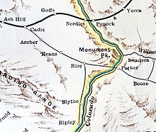
Rice Army Air Field is an abandoned World War II airfield in Rice Valley of the southern Mojave Desert, located 1-mile (1.6 km) east-southeast of the community of Rice. The airfield is located in Riverside County just south of the San Bernardino county line and State Route 62.

<span class="mw-page-title-main">W. R. Byron Airport</span> Airport in Riverside County, California

W. R. Byron Airport is a privately owned, private use airport in Riverside County, California, United States. It is located four nautical miles northwest of the central business district of Blythe, California, within the city limits.

<span class="mw-page-title-main">Desert Training Center</span> US Army training centers during World War II

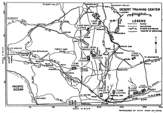
The Desert Training Center (DTC), also known as California–Arizona Maneuver Area (CAMA), was a World War II training facility established in the Mojave Desert and Sonoran Desert, largely in Southern California and Western Arizona in 1942.

<span class="mw-page-title-main">Desert Center Airport</span> Airport in California, United States

Desert Center Airport is a private-use airport located five nautical miles northeast of the central business district of Desert Center, in Riverside County, California, United States.

<span class="mw-page-title-main">Riverside County, California</span> County in California, United States

Riverside County is a county located in the southern portion of the U.S. state of California. As of the 2020 census, the population was 2,418,185, making it the fourth-most populous county in California and the 10th-most populous in the United States. The name was derived from the city of Riverside, which is the county seat.

<span class="mw-page-title-main">Arizona and California Railroad</span> Short line railroad in the Southwestern United States

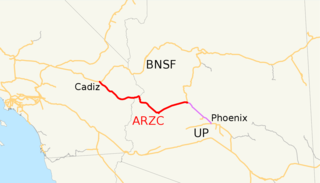
The Arizona and California Railroad is a class III short line railroad that was a subdivision of the Atchison, Topeka and Santa Fe Railway (ATSF). The ARZC began operations on May 9, 1991, when David Parkinson of the ParkSierra RailGroup purchased the line from the Santa Fe Railway. ParkSierra Railgroup was purchased in January 2002 by shortline railroad holding company RailAmerica. The Genesee & Wyoming shortline railroad holding company purchased RailAmerica in December 2012. ARZC's main commodities are petroleum gas, steel, and lumber; the railroad hauls around 12,000 carloads per year.

<span class="mw-page-title-main">Palo Verde Valley</span>

The Palo Verde Valley is located in the Lower Colorado River Valley, next to the eastern border of Southern California with Arizona, United States. It is located on the Colorado Desert within the Sonoran Desert south of the Parker Valley. Most of the valley is in Riverside County, with the southern remainder in Imperial County. La Paz County borders to the east on the Colorado River.

<span class="mw-page-title-main">Rice Valley</span> Landform in Riverside County, Arizona

The Rice Valley is a valley of the southeastern Mojave Desert, located within Riverside County, California.

<span class="mw-page-title-main">Camp Coxcomb</span> California Historic Landmark

The Camp Coxcomb was a sub camp of the US Army Desert Training Center in Riverside County, California. The main headquarters for the Desert Training Center was Camp Young where General Patton's 3rd Armored Division was stationed. Camp Coxcomb was designated a California Historic Landmark (No.985). The site of the Camp Granite is 45 miles East of Indio, California off Interstate 10 and California State Route 177 near the Coxcomb Mountains. The train stop at Freda railroad siding delivered Troops and equipment. The camp closed in early in 1944 after about two years of operations.

<span class="mw-page-title-main">California during World War II</span>

California during World War II was a major contributor to the World War II effort. California's long Pacific Ocean coastline provided the support needed for the Pacific War. California also supported the war in Europe. After the Japanese attack on Pearl Harbor on December 7, 1941, most of California's manufacturing was shifted to the war effort. California became a major ship builder and aircraft manufacturer. Existing military installations were enlarged and many new ones were built. California trained many of the troops before their oversea deployment. Over 800,000 Californians served in the United States Armed Forces. California agriculture, ranches and farms were used to feed the troops around the world. California's long coastline also put the state in fear, as an attack on California seemed likely. California was used for the temporary and permanent internment camps for Japanese Americans. The population grew significantly, largely due to servicemen who were stationed at the new military bases/training facilities and the mass influx of workers from around the U.S. in the growing defense industries. With all the new economy activity, California was lifted out of the Great Depression. Over 500,000 people moved to California from other states to work in the growing economy. California expanded its oil and mineral production to keep up with the war demand.

<span class="mw-page-title-main">Condor Field</span> Airbase in Twentynine Palms, California

Condor Field was an airbase located in Twentynine Palms, California used for training both in World War II and the Korean War. From 1939 to 1942, and from 1945 to 1949, it was operated as a civil airport. The now-abandoned airfield is on the Marine Corps Air Ground Combat Center Twentynine Palms. In about 1939, a 3,000-foot runway was built at the southeast edge of dry lake Mesquite Lake as a civil field and named Twenty Nine Palms Airfield.

References

  1. "Rice, California". Geographic Names Information System . United States Geological Survey, United States Department of the Interior.
  2. Defined as "A portion of a division designated by timetable." http://www.transportation-dictionary.org/Railroad-Dictionary/Subdivision Railroad Dictionary; accessed July 31, 2012
  3. "Thermal Army Air Field / Naval Air Facility, Thermal". militarymuseum.org. Retrieved November 9, 2015.
  4. 1 2 Abandoned & Little-Known Airfields: California: Southeastern San Bernardino County
  5. "Auto trips were made to the regions north and south of Grants and Thoreau, the Tularosa basin, the Jornada del Muerto Valley, and the desert training area. Aerial surveys were made at low altitude by one or another of the group, K. Bainbridge, R. W. Henderson, Maj. W. A. Stevens, and Maj. P. deSilva, over the same areas. The choices finally narrowed to either the Jornada del Muerto region in the northwest corner of the Alamogordo Bombing Range or the desert training area north of Rice, CA." Kenneth T. Bainbridge, "Trinity" (LA-6300-H), May 1976 (reprinting a 1947 report).
  6. Travis, Joan M. (April 13, 2011). "Film crew gives Parker area economic boost". Parker Pioneer. Retrieved April 21, 2016.