
Twenty-mule teams were teams of eighteen mules and two horses attached to large wagons that transported borax out of Death Valley from 1883 to 1889. They traveled from mines across the Mojave Desert to the nearest railroad spur, 165 miles (266 km) away in Mojave. The routes were from the Harmony and Amargosa Borax Works to Daggett, California, and later Mojave, California. After Harmony and Amargosa shut down in 1888, the mule team's route was moved to the mines at Borate, 3 miles (5 km) east of Calico, back to Daggett. There they worked from 1891 until 1898 when they were replaced by the Borate and Daggett Railroad.
Goffs, an unincorporated community in San Bernardino County, California, is a nearly empty one-time railroad town at the route's high point in the Mojave Desert. Goffs was a stop on famous U.S. Route 66 until 1931 when a more direct road opened between Needles and Essex. Goffs was also home to workers of the nearby Santa Fe Railroad, with Homer east, Fenner south, and Blackburn and Purdy north.
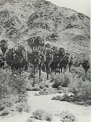
Corn Springs is a palm oasis situated in the Chuckwalla Mountains of the Colorado Desert in Riverside County, California, United States, seventeen miles southeast of Desert Center. Native Americans relied on the springs, and they engraved many petroglyphs on the rocks in the area. In the late 19th century, miners in the area also relied on the springs, and they established the Corn Springs Mining District in 1897.

Lanfair Valley is located in the Mojave Desert in southeastern California near the Nevada state line. It is bounded on the north by the New York Mountains and Castle Mountains, on the east by the Piute Range, and on the south by the Woods Mountains and Vontrigger Hills. Joshua Trees can be found in most of the valley. Elevation is 4,045 feet.

The Marl Mountains are located in the Mojave National Preserve in eastern California in the United States, northeast of the Kelso Mountains. The Marl Mountains lie just east of Kelbaker Road, which connects the town of Baker with the small community of Kelso, California.
Clipper Valley is a vast, oval-shaped alluvial plain located in the eastern Mojave Desert, in San Bernardino County, California, in the south of the Mojave National Preserve. Interstate 40 passes the valley along its southern border, and Needles, California and the Colorado River are to the east.
The Mojave Road, also known as Old Government Road, is a historic route and present day dirt road across what is now the Mojave National Preserve in the Mojave Desert in the United States. This rough road stretched 147 miles (237 km) from Beale's Crossing, to Fork of the Road location along the north bank of the Mojave River where the old Mojave Road split off from the route of the Old Spanish Trail/Mormon Road.
Vanderbilt was a short-lived gold mining town located in San Bernardino County, California, United States. It existed between 1893 and 1895. At its peak it may have had a population of about 400 people.

Ivanpah was a short-lived silver mining town located in San Bernardino County, California, United States. It was founded in 1869 and existed until at least the mid-1880s.
Noonday Camp, also known as Mill City, Noonday City, and Tecopa, is a ghost town located in the Mojave Desert east of Tecopa in Inyo County, California.

Jawbone Canyon is a geographic feature in the Mojave Desert and a Bureau of Land Management area located in Kern County, California, 20 miles (32 km) north of Mojave on CA 14 near Cantil, CA. The area is a popular destination for hikers and off road vehicle enthusiasts.
Dos Palmas Spring is an artesian spring in Riverside County, California where it lies at the foot of the Orocopia Mountains. It is only one of several such springs in the area that create an oasis in the Colorado Desert there.
Bitter Spring is a spring within the Fort Irwin National Training Center in San Bernardino County, California. It lies at an elevation of 1355 feet and is located in a valley between the Soda Mountains to the east, the Tiefort Mountains to the northwest, Alvord Mountain to the southwest and Cronese Mountains to the south and southeast.
Fork of the Road was the locale along the Mojave River where the junction of the Mojave Trail / Mojave Road and the Old Spanish Trail / Mormon Road was located in San Bernardino County, California. The location of Fork of the Road was on the north side of the Mojave River, 18.75 miles southwest of Bitter Spring, about 14.5 miles east of Grapevine, and 10.9 miles west of Camp Cady. The location was an oasis where the Mojave River came to the surface. There travelers could get water, camp, rest and graze their animals before or after crossing the desert.
Mormon Road, also known to the 49ers as the Southern Route, of the California Trail in the Western United States, was a seasonal wagon road pioneered by a Mormon party from Salt Lake City, Utah led by Jefferson Hunt, that followed the route of Spanish explorers and the Old Spanish Trail across southwestern Utah, northwestern Arizona, southern Nevada and the Mojave Desert of California to Los Angeles in 1847. From 1855, it became a military and commercial wagon route between California and Utah, called the Los Angeles – Salt Lake Road. In later decades this route was variously called the "Old Mormon Road", the "Old Southern Road", or the "Immigrant Road" in California. In Utah, Arizona and Nevada it was known as the "California Road".
Lanfair Buttes, also known as Eagle Mountain, Indian Hill, Eagle Hill, Graveyard Hills is a summit in the Mojave National Preserve in the Mojave Desert in San Bernardino County, California. The Lanfair Buttes lie 3 miles (4.8 km) east-southeast of the Grotto Hills and 8 miles (13 km) north-northeast of Hackberry Mountain in Lanfair Valley. The tallest and northernmost elevation in the Lanfair Buttes is Eagle Mountain at 1338 feet. The southernmost elevation is Indian Hill, at 35°08′36.71″N115°09′15.34″W at an elevation of 1281 feet. Indian Well, an old well is found west of the Buttes at 35°08′43″N115°09′32″W, and petroglyphs are found nearby on the slope of the Buttes to the east. Indian Well petroglyphs indicate it was a Native American water source and camping site in previous centuries. Indian Well was also located along the route of the Mohave Trail.
Indian Well is a locale, an old well, at the foot of the southwestern slope of the Lanfair Buttes, northwest of the summit of Indian Hill. It is located a little over a mile north of the Mojave Road in the Mojave Desert in San Bernardino County, California. Native American Petroglyphs are found nearby Indian Well, on the western slope of the Buttes. The Indian Well petroglyphs indicate it was a Native American water source and camping site in previous centuries. Indian Well was also located along the route of the Mohave Trail.
Marl Spring is a spring in San Bernardino County, California. It lies an elevation of 3,901 miles / 1,189 meters on the northeastern part of the Marl Mountains.
Salt Spring, sometimes called Salt Springs, was a spring in the Mojave Desert, in San Bernardino County, California. It was a spring along the course of Salt Creek a tributary of the Amargosa River.

The Mojave Road Los Angeles was designated a California Historic Landmark on March 19, 1985. It runs from Drum Barracks in Los Angeles County to the Colorado River in San Bernardino County, California

