Related Research Articles

In archaeology, a denticulate tool is a stone tool containing one or more edges that are worked into multiple notched shapes, much like the toothed edge of a saw. Such tools have been used as saws for woodworking, processing meat and hides, craft activities and for agricultural purposes. Denticulate tools were used by many different groups worldwide and have been found at a number of notable archaeological sites. They can be made from a number of different lithic materials, but a large number of denticulate tools are made from flint.

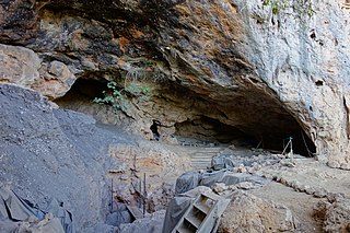
The Matobo National Park forms the core of the Matobo or Matopos Hills, an area of granite kopjes and wooded valleys commencing some 35 kilometres (22 mi) south of Bulawayo, southern Zimbabwe. The hills were formed over 2 billion years ago with granite being forced to the surface, this has eroded to produce smooth "whaleback dwalas" and broken kopjes, strewn with boulders and interspersed with thickets of vegetation. Matopo/Matob was named by the Lozwi, who are the ancestors of Kalanga. A different tradition states that the first King, Mzilikazi Khumalo when told by the local residents that the great granite domes were called madombo he replied, possible half jest, "We will call them matobo" - an IsiNdebele play on 'Bald heads'.

The Tsodilo Hills are a UNESCO World Heritage Site (WHS), consisting of rock art, rock shelters, depressions, and caves in southern Africa. It gained its WHS listing in 2001 because of its unique religious and spiritual significance to local peoples, as well as its unique record of human settlement over many millennia. UNESCO estimates there are over 4500 rock paintings at the site. The site consists of a few main hills known as the Child Hill, Female Hill, and Male Hill.
Mumba Cave, located near the highly alkaline Lake Eyasi in Karatu District, Arusha Region, Tanzania. The cave is a rich archaeological site noted for deposits spanning the transition between the Middle Stone Age and Late Stone Age in Eastern Africa. The transitional nature of the site has been attributed to the large presence of its large assemblage of ostrich eggshell beads and more importantly, the abundance of microlith technology. Because these type artifacts were found within the site it has led archaeologists to believe that the site could provide insight into the origins of modern human behavior. The cave was originally tested by Ludwig Kohl-Larsen and his wife Margit in their 1934 to 1936 expedition. They found abundant artifacts, rock art, and burials. However, only brief descriptions of these findings were ever published. That being said, work of the Kohl-Larsens has been seen as very accomplished due to their attention to detail, especially when one considers that neither was versed in proper archaeological techniques at the time of excavation. The site has since been reexamined in an effort to reanalyze and complement the work that has already been done, but the ramifications of improper excavations of the past are still being felt today, specifically in the unreliable collection of C-14 data and confusing stratigraphy.
Howiesons Poort is a lithic technology cultural period in the Middle Stone Age in Africa named after the Howieson's Poort Shelter archeological site near Grahamstown in South Africa. It seems to have lasted around 5,000 years between roughly 65,800 BP and 59,500 BP.

Raymonden is a prehistoric cave near Chancelade in the French département Dordogne. The cave was inhabited during the Upper Paleolithic and contained, besides many artefacts, a human skeleton.
Darra-e Kūr or Bābā Darwīsh, is an archaeological site in Badakhshan province in Afghanistan. It is situated just northeast of Kalafgān near the village of Chinār-i Gunjus Khān 63 km (39.1 mi) east of Taloqan, on the road to Faizabad. The cave is situated atop the side of the valley near the hamlet of Bābā Darwīsh.

Hazar Merd is a group of Paleolithic cave sites excavated by Dorothy Garrod in 1928. The caves are located south-southwest of Sulaymaniyah in Sulaymaniyah Governorate in Iraq. Garrod's soundings in two caves in the Hazar Merd group provided evidence of Middle and Epi-Paleolithic occupation.The Dark cave or Ashkawty Tarik in Kurdish has a commanding view of the local valley and is close to a small spring and a village with the same name.
Cloggs Cave is a limestone cave and rockshelter with significant Aboriginal archaeological deposits, located on a cliff along the Snowy River gorge near the town of Buchan, Victoria.

Damjili – is a half-circular shaped cave site in Azerbaijan, where evidence of prehistoric human presence during the Paleolithic and Mesolithic was discovered.

The Taghlar cave is an archaeological site that was inhabited by prehistoric humans of the Mousterian culture during the Paleolithic. The cave is located in Azerbaijan, in the disputed region of Nagorno-Karabakh, in the southern part of Boyuk Taghlar village, on the left banks of the Guruchay River.

Nelson Bay Cave also known as Wagenaar's Cave is a Stone Age archaeological site located on the Robberg Peninsula and facing Nelson's Bay near Plettenberg Bay in South Africa, and showing evidence of human occupation as far back as 125,000 years ago.
Taforalt or Grotte des Pigeons is a cave in the province of Berkane, Béni Iznasen region, Morocco, possibly the oldest cemetery in North Africa. It contained at least 34 Iberomaurusian adolescent and adult human skeletons, as well as younger ones, from the Upper Palaeolithic between 15,100 and 14,000 calendar years ago. There is archaeological evidence for Iberomaurusian occupation at the site between 23,200 and 12,600 calendar years ago, as well as evidence for Aterian occupation as old as 85,000 years.
Haua Fteah is a large karstic cave located in the Cyrenaica in northeastern Libya. This site has been of significance to research on African archaeological history and anatomically modern human prehistory because it was occupied during the Middle and Upper Paleolithic, the Mesolithic and the Neolithic. Evidence of modern human presence in the cave date back to 200,000 BP.
Melkhoutboom Cave is an archaeological site dating to the Later Stone Age, located in the Zuurberg Mountains, Cape Folded Mountain Belt, Sarah Baartman District Municipality in the Eastern Cape Province of South Africa.
Qafzeh Cave, also known by other names, is a prehistoric archaeological site located at the bottom of Mount Precipice in the Jezreel Valley of Lower Galilee south of Nazareth. Important remains of prehistoric people were discovered on the site - some of the oldest examples in the world, outside of Africa, of virtually anatomically modern human beings. These were discovered on the ledge just outside the cave, where 18 layers from the Middle Paleolithic era were identified. The interior of the cave contains layers ranging from the Neolithic era to the Bronze age.
Stone Age in Azerbaijan is divided into the Paleolithic, Mesolithic, and Neolithic periods. It was studied in Karabakh, Gazakh, Lerik, Gobustan, and Nakhchivan. Stone materials belonging to the Stone Age were found by Mammadali Huseynov in the Shorsu gorge located near the village of Gyrag Kasaman in Qazakh region. According to his research, people have first settled in the territory of Azerbaijan 2 million years ago. The Stone Age era involved two different human species: Homo neanderthalensis and Homo sapiens.
Rose Cottage Cave (RCC) is an archaeological site in the Free State, South Africa, situated only a few kilometers away from Ladybrand close to the Caledon River on the northern slopes of the Platberg. RCC is an important site because of its long cultural sequence, its roots of modern human behavior, and the movement of early modern humans out of Africa. Rose Cottage is the only site from the Middle Stone Age that can tell us about the behavioral variability of hunter-gatherers during the Late Pleistocene and Holocene. Berry D. Malan excavated the site between 1943 and 1946, shortly succeeded by Peter B. Beaumont in the early 1960s, and the most recent excavations occurred from 1987 to 1997 by Lyn Wadley, and Philip Harper in 1989 under Wadley's supervision. Humans have inhabited of Rose Cottage for over 100,000 years throughout the Middle and Later Stone Ages. Site formation and sediment formation processes at Rose Cottage appear to be primarily anthropogenic. Archaeological research focuses primarily on blade technology and tool forms from the Middle Stone Age and the implications of modern human behavior. Structurally, the cave measures more than 6 metres (20 ft) deep and about 20 by 10 metres. A boulder encloses the front, protecting the cave, but allowing a small opening for a skylight and narrow entrances on both the east and west sides.
Porc-Epic Cave is an archaeological site located in Dire Dawa, Ethiopia. Dated back to the Middle Stone Age, the site contains extensive evidence of microlithic tools, bone, and faunal remains. The lithic assemblage reveals that inhabitants at the time were well-organized with their environment. There is also rock art and strong evidence for ochre processing. The site was first discovered in 1920 by H. De Monfreid and P. Teilhard De Chardin. H. Breuil and P. Wernert performed the first excavation in 1933, followed from 1974 to 1976 by J. Desmond Clark and K.D. Williamson. Succeeding this was an excavation in 1998. Porc-Epic Cave provides insight into the behavior and technical capability of modern humans in eastern Africa during the Middle Stone Age.
The Fisher Mound Group is a group of burial mounds with an associated village site located on the DesPlaines River near its convergence with the Kankakee River where they combine to form the Illinois River, in Will County, Illinois, about 60 miles southwest of Chicago. It is a multi-component stratified site representing several Prehistoric Upper Mississippian occupations as well as minor Late Woodland and Early Historic components.
References
- ↑ Matobo Hills World Heritage Area (PDF). UNESCO. 2003.
- 1 2 3 4 5 6 7 8 9 10 11 12 13 14 15 Armstrong, A. Leslie (1931). Rhodesian archaeological expedition (1929) : excavations in Bambata cave and researches on prehistoric sites in Southern Rhodesia. London: Royal Anthropological Institute of Great Britain and Ireland.
- ↑ "Matopo Hills | hills, Zimbabwe". Encyclopedia Britannica. Retrieved 25 February 2019.
- ↑ "Jones, Reverend Neville (archaeology, entomology)". S2A3 Biographical Database of Southern African Science. Retrieved September 29, 2019.
- 1 2 K. R. Robinson (1966). "Bambata Ware; Its Position in the Rhodesian Iron Age in the Light of Recent Evidence". The South African Archaeological Bulletin. South African Archaeological Society. 21 (82): 81–85. doi:10.2307/3888032. JSTOR 3888032.
- ↑ N. J. Walker (1983). "The Significance of an Early Date for Pottery and Sheep in Zimbabwe". The South African Archaeological Bulletin. 38 (138): 88–92. doi:10.2307/3888641. JSTOR 3888641.
- ↑ Thomas N. Huffman (2005). "The stylistic origin of Bambata and the spread of mixed farming in southern Africa". Southern African Humanities. 17: 57–79.
- ↑ Lan Shaw, Robert Jameson, ed. (2008). A Dictionary of Archaeology. John Wiley & Sons. ISBN 9780470751961.