
Kashafrud Basin(کشفرود) is an archaeological site in Iran, known for the Lower Palaeolithic artifacts collected there; these are the oldest-known evidence for human occupation of Iran.
The Baradostian culture was an Upper Paleolithic flint industry culture found in the Zagros region in the border-country between Iraq and Iran. It was preceded by the Middle Paleolithic Mousterian culture, directly overlying it without an intervening bladelet industry. This culture is known for the high percentage of burins and some of these were similar to the distinctive nosed profile of the Aurignacian burins. Baradost is one of the mountains in the Zagros Mountains in Iraq.

The Do-Ashkaft Cave, being a Middle Paleolithic cave site, is located north of Kermanshah, near Taq-e Bostan, Iran about 1,600 m (5,200 ft) above sea level. Its entrance faces south of Meywala Mount, overlooking the national park of Kuhestan. The site was first visited in 1996 by Iranian researchers F. Biglari and S. Heydari-Guran and during the following four years a series of surface surveys were made at one-month intervals, which resulted in a rich collection of Middle Paleolithic lithic artifacts.
Harold Lewis Dibble was an American Paleolithic archaeologist. His main research concerned the lithic reduction, during which he conducted fieldwork in France, Egypt, and Morocco. He was a professor of Anthropology at the University of Pennsylvania and Curator-in-Charge of the European Section of the University of Pennsylvania Museum of Archaeology and Anthropology.
Warwasi is a Paleolithic rockshelter site located at north of Kermanshah in western Iran. It was excavated by Bruce Howe under direction of late Robert Braidwood in the 1960s. This site contains a rich archaeological sequence from Middle Paleolithic to late Epipaleolithic.

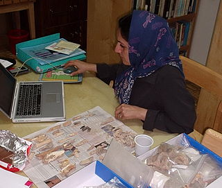
Fereidoun Biglari is an Iranian archaeologist and a museum curator.
Marjan Mashkour is an archaeologist and member of the French National Centre for Scientific Research. She is the first Iranian to specialize in the field of zooarchaeology and has been engaged in many field and laboratory projects in Iran and the Near East.
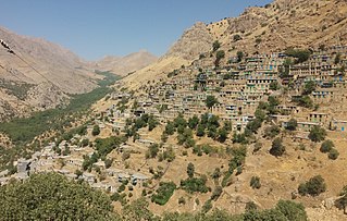
Cultural Landscape of Hawraman or Cultural Landscape of Uramanat is the 26th tangible cultural heritage of Iran. This remote and mountainous landscape bears testimony to the traditional culture of the Hawrami people, an agropastoral Kurdish tribe that has inhabited the region since about 3000 BCE. The property, at the heart of the Zagros Mountains in the provinces of Kurdistan and Kermanshah along the western border of Iran.

The Wezmeh Cave is an archaeological site near Islamabad Gharb, western Iran, around 470 km (290 mi) southwest of the capital Tehran. The site was discovered in 1999 and excavated in 2001 by a team of Iranian archaeologists under the leadership of Dr. Kamyar Abdi. Wezmeh cave was re-excavated by a team under direction of Fereidoun Biglari in 2019.

Qal'eh Bozi is a complex of caves sites located about 25 km (15.5 mi) south-southwest of Isfahan, Iran; northeast of Dizicheh and north of Hassanabad. The sites include two rock shelters and a cave located at altitudes between 1,750 and 1,810 m above sea level. The caves are found on the southern face of a limestone mountain of lower Cretaceous age that rises to more than 500 m (1,640.4 ft) above the plain floor. From the cave entrance there is a commanding view of the plain below and of the Zaiandeh Rud River flowing about 2 km (1.2 mi) to the south and southeast.

Jacques Jaubert is a French prehistorian and professor of Paleolithic archaeology at University of Bordeaux 1.

The prehistory of the Iranian plateau, and the wider region now known as Greater Iran, as part of the prehistory of the Near East is conventionally divided into the Paleolithic, Epipaleolithic, Neolithic, Chalcolithic, Bronze Age and Iron Age periods, spanning the time from the first settlement by archaic humans about a million years ago until the beginning of the historical record during the Neo-Assyrian Empire, in the 8th century BC.

The Mladečské Caves are a cave complex in the municipality of Mladeč in the Czech Republic. It is located in the Třesín National Nature Monument within the Litovelské Pomoraví Protected Landscape Area.

Maiwala or Farokhshad is a mountain of the Zagros Mountains, located in western Iran, north of the city of Kermanshah. It is one of the mountains of Paraw range, with an altitude of 2445 above sea level. It is about 5 km long from the Tang-e Malavard at west to Taq-e Kenesht at east. The mountain is contained several caves of which some are archaeological.

Frank Hole is an American Near Eastern archaeologist known for his work on the prehistory of Iran, the origins of food production, and the archaeology of pastoral nomadism. He is C. J. MacCurdy Professor Emeritus of Anthropology at Yale University.
The Ahmarian culture was a Paleolithic archeological industry in Levant dated at 46,000–42,000 BP and thought to be related to Levantine Emiran and younger European Aurignacian cultures.

Darian Dam was constructed on the Sirwan River between 2009 and 2015. The Dam is located in the Hawrāmān region of Kurdistan and Kermanshah. The Darian Dam Archeological Salvage Program (DDASP) was planned by Iranian Center for Archaeological Research before flooding the reservoir.

Anna Belfer-Cohen is an Israeli archaeologist and paleoanthropologist and Professor Emeritus at the Institute of Archaeology, The Hebrew University of Jerusalem. Belfer-Cohen excavated and studied many important prehistoric sites in Israel including Hayonim and Kebara Caves and open-air sites such as Nahal Ein Gev I and Nahal Neqarot. She has also worked for many years in the Republic of Georgia, where she made important contributions to the study of the Paleolithic sequence of the Caucasus following her work at the cave sites of Dzoudzuana, Kotias and Satsrublia. She is a specialist in biological Anthropology, prehistoric art, lithic technology, the Upper Paleolithic and modern humans, the Natufian-Neolithic interface and the transition to village life.

Malaverd is an archaeological site in the north of Kermanshah, in Iran. It is located in the Tang-e Malaverd valley, at the western end of Mount Meywala, about 8 km (26,247 ft) from the west of Taq-e Bostan. Malaverd is one of the Paleolithic cave sites in the south of Mount Meywala. This site was recorded during a survey conducted be Fereidoun Biglari in 1999 and registered in the Iran National Heritage List in 2005. The site was excavated by a team of archaeologists under the direction of Sonia Shidrang in August 2012. The site contained a 170 cm thick sequence of archaeological deposits. The excavations revealed that the cave was occupied during the Middle Paleolithic, Upper Paleolithic, Chalcolithic, Iron Age III, and Parthian. The cave is the first Upper Paleolithic site in the Kermanshah region that was excavated by an Iranian archaeologist and the first dated Upper Paleolithic site in the region. The other important cave site near Malaverd is Do-Ashkaft Cave.

Darai Rockshelter is an archaeological site in the southwest of Kurdistan Province, in west Iran. It is located in the Sirwan River valley, between Naw and Asparez villages, in the Hawraman region. It faces NNW at an altitude of 760m a.s.l.The shelter was discovered during Darian Dam Archaeological Salvage Program in 2015, excavated in 2015–2016, and it was subsequently submerged in 2016.


