
A cave or cavern is a natural void in the ground, specifically a space large enough for a human to enter. Caves often form by the weathering of rock and often extend deep underground. The word cave can refer to smaller openings such as sea caves, rock shelters, and grottos, that extend a relatively short distance into the rock and they are called exogene caves. Caves which extend further underground than the opening is wide are called endogene caves.

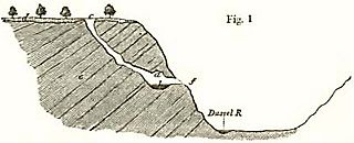
A sinkhole is a depression or hole in the ground caused by some form of collapse of the surface layer. The term is sometimes used to refer to doline, enclosed depressions that are locally also known as vrtače and shakeholes, and to openings where surface water enters into underground passages known as ponor, swallow hole or swallet. A cenote is a type of sinkhole that exposes groundwater underneath. Sink and stream sink are more general terms for sites that drain surface water, possibly by infiltration into sediment or crumbled rock.

Hạ Long Bay or Halong Bay is a UNESCO World Heritage Site and popular travel destination in Quảng Ninh Province, Vietnam. The name Hạ Long means "descending dragon". Administratively, the bay belongs to Hạ Long city, Cẩm Phả city, and is a part of Vân Đồn district. The bay features thousands of limestone karsts and isles in various shapes and sizes. Hạ Long Bay is a center of a larger zone which includes Bai Tu Long Bay to the northeast, and Cát Bà Island to the southwest. These larger zones share a similar geological, geographical, geomorphological, climate, and cultural characters.

The Li River or Li Jiang is the name for the upper reaches of the Gui River in northwestern Guangxi, China. It is part of the Xijiang River system in the Pearl River basin, flowing 164 kilometres (102 mi) from Xing'an County to Pingle County.

Winnemucca Lake is a dry lake bed in northwest Nevada that features the oldest known petroglyphs in North America. Located astride the border between Washoe and Pershing counties, it was a shallow lake until the 1930s, but was dried when a dam and a road were built that combined to restrict and block water flow. It was formerly designated as a National Wildlife Refuge, but its status as a refuge was removed due to the lack of water.

The Rock of Gibraltar is a monolithic limestone promontory located in the British territory of Gibraltar, near the southwestern tip of Europe on the Iberian Peninsula, and near the entrance to the Mediterranean. It is 426 m (1,398 ft) high. Most of the Rock's upper area is covered by a nature reserve, which is home to around 300 Barbary macaques. These macaques, as well as a labyrinthine network of tunnels, attract many tourists each year.
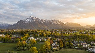
The Untersberg is the northernmost massif of the Berchtesgaden Alps, a prominent spur straddling the border between Berchtesgaden, Germany and Salzburg, Austria. The highest peak of the table-top mountain is the Berchtesgaden Hochthron at 1,973 metres (6,473 ft).

The Edakkal caves are two natural caves at a remote location at Edakkal, 25 km (15.5 mi) from Kalpetta in the Wayanad district of Kerala in India. It connects the Western Ghats and the Eastern Ghats. They lie 1,200 m (3,900 ft) above sea level on Ambukutty Mala, near an ancient trade route connecting the high mountains of Mysore to the ports of the Malabar Coast. Inside the caves are pictorial writings believed to date to at least 6,000 BCE, from the Neolithic man, indicating the presence of a prehistoric settlement in this region. The Stone Age carvings of Edakkal are rare and are the only known examples from South India besides those of Shenthurini, Kollam, also in Kerala. The cave paintings of Shenthurini (Shendurney) forests in Kerala are of the Mesolithic era.
Karaca Cave is a network of caves located near the town of Torul in Gümüşhane Province, Turkey.

The Pomier Caves are a series of 55 caves located north of San Cristobal in the south of the Dominican Republic. They contain the largest collection of rock art in the Caribbean created since 2,000 years ago primarily by the Taíno people but also the Carib people and the Igneri, the pre-Columbian indigenous inhabitants of the Bahamas, Greater Antilles, and some of the Lesser Antilles. These caves have been damaged by the uncontrolled mining of limestone nearby.

Hato Caves are show caves, publicly accessible since 1991 and a popular tourist attraction on the Caribbean island of Curaçao. The caves consist of marine coral limestone, which accumulated over millions of years and after sea levels had dropped were exposed to atmospheric corrosion and karstic processes. They are approximately 240 m (790 ft) long and cover an area of 4,900 m2 (53,000 sq ft).

Of the several caves of Aruba, three Aruban caves are well known, seen in deep crevices on the windward face of the island. All three of the caves are located in the Arikok National Park. The most prominent are Guadirikiri Cave, the Fontein Cave and the Huliba Cave. Nocturnal bats nestle in all these caves.
Kleine Feldhofer Grotte was a karstic limestone cave and a paleoanthropologic site in the Neander Valley in western Germany. In August 1856, the Neanderthal type specimen was unearthed from the cave. Miners uncovered a skull cap and a number of skeletal bones to be labeled Neanderthal. The bones belong to at least three distinct individuals.

Deer Cave, located near Miri, Sarawak, Malaysia, is a show cave attraction of Gunung Mulu National Park. It was surveyed in 1961 by G. E. Wilford of the British Borneo Geological Survey, who predicted that Mulu would yield many more caves in the future. The cave, which is also known as Gua Payau or Gua Rusa by the local Penan and Berawan people, is said to have received its name because of the deer that go there to lick salt-bearing rocks and shelter themselves.
Aravan is a large village in the Fergana Valley, in Aravan District of Osh Region, Kyrgyzstan, Central Asia about 25 km west of Osh, on the river Aravansay. It is the administrative seat of Aravan District. Its population was 32,917 in 2021, of which 21,818 in Yusupov rural community and 11,099 in Allya Anarov rural community.
The Caves of the Tullybrack and Belmore hills are a collection of caves in southwest County Fermanagh, Northern Ireland. The region is also described as the West Fermanagh Scarplands by environmental agencies and shares many similar karst features with the nearby Marble Arch Caves Global Geopark.
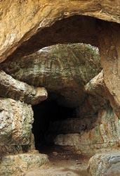
The Szelim cave is located in northwestern Hungary at the western margin of the Gerecse Mountains, 289 m (948 ft) above the Által-ér Valley near Tatabánya city. The cave interior is 45 m (148 ft) long and 14 m (46 ft) high. The site has been regularly frequented and used as a shelter by local villagers over the centuries, is easily accessible and its huge rectangular entrance features a memorial of the Turul.
Koongine Cave is located in the Limestone Coast of South Australia.
Pınargözü Cave, is a cave 18 kilometres (11 mi) west of the town of Yenişarbademli in Isparta Province, Turkey. It is considered the longest cave in Turkey, although it has not yet been fully explored, and the precise extent to which it has been explored is in dispute.
The 1973 Mount Gambier cave diving accident was a scuba diving incident in 1973 at a flooded sinkhole known as "The Shaft" near Mount Gambier in South Australia. The incident claimed the lives of four recreational scuba divers: siblings Stephen and Christine M. Millott, Gordon G. Roberts, and John H. Bockerman. The four divers explored beyond their own planned limits, without the use of a guideline, and subsequently became lost, eventually exhausting their breathing air and drowning. As of May 2015, they are the only known fatalities at the site. Four other divers from the same group survived.

