Bath Township, Summit County, Ohio

Last updated

Bath Township, Summit County, Ohio
WESTERN RESERVE VILLAGE, AN HISTORIC PRESERVATION AT HALE HOMESTEAD - NARA - 550287.jpg
Summit County Ohio incorporated and unincorporated areas Bath Township highlighted.svg
Location in Summit County and the state of Ohio.
Coordinates: 41°9′29″N81°38′0″W / 41.15806°N 81.63333°W / 41.15806; -81.63333
CountryUnited States
StateOhio
County Summit
Area
  Total22.5 sq mi (58.2 km2)
  Land22.3 sq mi (57.7 km2)
  Water0.2 sq mi (0.4 km2)
Elevation
[1]
948 ft (289 m)
Population
 (2020) [2]
  Total10,024
  Density449.5/sq mi (173.7/km2)
Time zone UTC-5 (Eastern (EST))
  Summer (DST) UTC-4 (EDT)
ZIP code
44210
Area code 330
FIPS code 39-04248 [3]
GNIS feature ID1086995 [1]
Website Bath Township

Bath Township is one of the nine townships of Summit County, Ohio, United States. A suburb of Akron, the 2020 census found 10,024 people in the township.

Contents

History

The township was originally known as Wheatfield when it was surveyed in 1808. The name was later changed to Hammondsburgh after Jason Hammond, who settled there in 1810. The name was changed to Bath when it fully separated from Richfield Township in 1818. [4] The origin of the name Bath is obscure; [5] it is said to have been so named for its brevity. [6]

In 1998, Bath Township formed a Joint Economic Development District (JEDD) with Akron and Fairlawn. The JEDD area has approximately 300 acres (1.2 km2) and is in the business district at the southern end of the township. [7]

Counties

Bath Township's land has been in the following counties: [8]

YearCounty
1796 Wayne
1800 Trumbull
1808 Portage
1811No county
1812 Medina
1840 Summit

Name

Statewide, other Bath Townships are located in Allen and Greene counties.

Geography

Located in the western part of the county, it borders the following townships and cities:

Several populated places are located in Bath Township:

Parts of the original Bath Township are now in Akron and Fairlawn.

It occupies most of survey Town 3, Range 12 in the Connecticut Western Reserve and is about 23 square miles (60 km2) in area.

Bath Township contains part of the Cuyahoga Valley National Park, whose main attraction within the township is the Hale Farm & Village, a historical community set in the 1800s.

Demographics

As of the census [9] of 2000, there were 9,635 people, 3,506 households, and 2,814 families residing in the township. The population density was 418.9 inhabitants per square mile (161.7/km2). There were 3,648 housing units at an average density of 158.6 per square mile (61.2/km2). The racial makeup of the township was 95.41% White, 1.59% African American, 0.04% Native American, 1.90% Asian, 0.11% from other races, and 0.94% from two or more races. Hispanic or Latino of any race were 0.80% of the population.

There were 3,506 households, out of which 34.6% had children under the age of 18 living with them, 42.4% were married couples living together, 4.6% had a female householder with no husband present, and 19.7% were non-families. 17.2% of all households were made up of individuals, and 8.93% had someone living alone who was 65 years of age or older. The average household size was 2.69 and the average family size was 3.06.

In the township the population was spread out, with 25.5% under the age of 18, 2.5% from 20 to 24, 20.5% from 25 to 44, 22.5% from 45 to 64, and 17.0% who were 65 years of age or older. The median age was 44.7 years. For every 100 females there were 89.95 males. For every 100 females age 18 and over, there were 93.6 males.

The median income for a household in the township was $88,899, and the median income for a family was $99,202. Males had a median income of $74,464 versus $43,529 for females. The per capita income for the township was $49,032. About 0.6% of families and 1.3% of the population were below the poverty line, including 0.8% of those under age 18 and 2.7% of those age 65 or over.

Government

The township is governed by a non-partisan three-member board of trustees, who are elected in November of odd-numbered years to a four-year term beginning on the following January 1. Two are elected in the year after the presidential election and one is elected in the year before it. There is also an elected township fiscal officer, who serves a four-year term beginning on April 1 of the year after the election, which is held in November of the year before the presidential election. Vacancies in the fiscal officership or on the board of trustees are filled by the remaining trustees. In 2016, the board was composed of president Elaina Goodrich and members Becky Corbett and James Nelson, and the fiscal officer was Sharon Troike. [10] Vito Sinopoli was named Township Administrator on October 23, 2012. [11]

Major court cases are handled by the Summit County court system and minor ones by the Akron Municipal Court.

Bath Township is served by its own police [12] and fire [13] departments.

Infrastructure

Transportation

Bath Township has access to Interstate 77 at two points. There is a full cloverleaf that the township shares with Copley Township at the intersection with State Route 18. There is also an exit at Ghent Road. I-77 has rest areas on both sides in the northern part of the township. Interstate 271 passes through the township's northwest corner without providing access. Bath Township is served by two state highways: State Route 18 follows the western part of the original southern edge of the township, while State Route 21 shares Interstate 77 on a mostly north–south path through the township. [14]

Education

Most of Bath Township is in the Revere Local School District, with part of the township being in the Copley-Fairlawn City School District. The portion that is in the Revere district is also in the Cuyahoga Valley Joint Vocational School District. (Summit County Fiscal Officer, 2005). Old Trail School, an independent co-ed day school is situated in Cuyahoga Valley National Park.

Economy

InfoCision Management Corporation is based in Bath Township.

Arts and Culture

Bath Nature Preserve

In 1997 and 1998, a 404-acre (1.63 km2) former Firestone property was purchased by Bath Township and named Bath Nature Preserve. It contains grasslands, wetlands, ponds, streams, and mesophytic and riparian deciduous forests, which has through an agreement been used by The University of Akron as a research station. [15] [16] It is used in ecology and biology research, and field trips are taken there by many biology classes to observe animals and collect samples for herbaria. [16] A map of the habitats in Bath Nature Preserve can be found here, and a list of species found and identified in the preserve can be found here.

Hale Farm and Village

Hale Farm and Village is a historic property of the Western Reserve Historical Society in Bath Township, Summit County, Ohio, United States. It is within the boundaries of the Cuyahoga Valley National Park. Hale Farm was the original homestead of Jonathan Hale, a Connecticut farmer who migrated to the Western Reserve in 1810. [17] In 1973 Hale Farm was listed on the National Register of Historic Places as the Jonathan Hale Homestead. The Hale House was built in 1825. [17]

Notable residents

Related Research Articles

<span class="mw-page-title-main">Summit County, Ohio</span> County in Ohio, United States

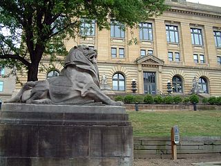
Summit County is an urban county in the U.S. state of Ohio. As of the 2020 census, the population was 540,428, making it the fourth-most populous county in Ohio. Its county seat and largest city is Akron. The county was formed on March 3, 1840, from portions of Medina, Portage and Stark Counties. It was named Summit County because the highest elevation on the Ohio and Erie Canal is located in the county.

<span class="mw-page-title-main">Portage County, Ohio</span> County in Ohio, United States

Portage County is a county in the U.S. state of Ohio. As of the 2020 census, the population was 161,791. Located in Northeast Ohio, Portage County is part of the Akron Metropolitan Statistical Area, which is also included in the Cleveland–Akron–Canton Combined Statistical Area. Its county seat is Ravenna and its largest city is Kent.

<span class="mw-page-title-main">Cuyahoga Falls, Ohio</span> City in Ohio, United States

Cuyahoga Falls is a city in Summit County, Ohio, United States. As of the 2020 census, the city population was 51,114. The second-largest city in Summit County, it is located directly north of Akron and is a suburb of the Akron metropolitan area. The city was founded in 1812 by William Wetmore and was originally named Manchester, but renamed for the Cuyahoga River and the series of waterfalls that run along the southern boundary of the city.

<span class="mw-page-title-main">Fairlawn, Ohio</span> City in Ohio, United States

Fairlawn is a city in western Summit County, Ohio, United States, and a suburb of Akron. The population was 7,710 at the 2020 census. It is part of the Akron metropolitan area.

<span class="mw-page-title-main">Munroe Falls, Ohio</span> City in Ohio, United States

Munroe Falls is a city in east-central Summit County, Ohio, United States, along the Cuyahoga River. The population was 5,044 at the 2020 census. It is a suburb of Akron and is part of the Akron metropolitan area.

<span class="mw-page-title-main">Peninsula, Ohio</span> Village in Ohio, United States

Peninsula is a village in northern Summit County, Ohio, United States, along the Cuyahoga River. The population was 536 at the 2020 census. It is part of the Akron metropolitan area.

<span class="mw-page-title-main">Stow, Ohio</span> City in Ohio, United States

Stow is a city in Summit County, Ohio, United States. The population was 34,483 at the 2020 census. It is a suburban community within the Akron metropolitan area.

<span class="mw-page-title-main">Tallmadge, Ohio</span> City in Ohio, United States

Tallmadge is a city in eastern Summit County, Ohio, United States, with a small district in neighboring Portage County. It is a suburb of Akron and part of the Akron metropolitan area. The population was 18,394 at the 2020 census. Tallmadge was founded in 1807 and is the second-oldest city in Summit County, following Hudson, which was founded in 1799.

<span class="mw-page-title-main">Norton, Ohio</span> City in Ohio, United States

Norton is a city in southwestern Summit County, Ohio, United States, with a 4.4-acre (1.8 ha) district extending into Wayne County. The population was 11,673 at the 2020 census. It is part of the Akron metropolitan area.

<span class="mw-page-title-main">Montrose, Ohio</span> Unincorporated community in Ohio, U.S.

Montrose is an unincorporated community on the border between Bath Township, Copley Township, and the city of Fairlawn in Summit County, Ohio, United States. It is an area of restaurants, stores, and businesses located along a stretch of State Route 18 near Interstate 77. The community is served by the Fairlawn (44333) post office. It is included in the Montrose-Ghent census-designated place. It had been a quiet hamlet for much of its history, with such establishments as a drive-in theater, golf courses, and a church. It became a busy retail area in the 1990s as new commercial development moved in.

<span class="mw-page-title-main">Hinckley Township, Medina County, Ohio</span> Township in Ohio, United States

Hinckley Township is one of the seventeen townships of Medina County, Ohio, United States, located in the northeast corner of the county. The 2020 census found 8,025 people in the township.

A Joint Economic Development District (JEDD) is an arrangement in Ohio where one or more municipalities and a township agree to work together to develop township land for commercial or industrial purposes. The benefit to the municipality is that they get a portion of the taxes levied in the JEDD without having to annex it. The benefits to the township are that it does not lose prime development land, it can still collect property taxes as well as a portion of the income tax collected, and it normally receives water from the municipality, which it may not otherwise have. In 1993, the Ohio General Assembly passed legislation enabling local communities to create JEDDs.

Northampton was one of the 16 original townships in Summit County, Ohio. It was in the middle of Summit County, bordering Akron and Cuyahoga Falls. No incorporated areas were formed within the township but Akron and Cuyahoga Falls expanded into Northampton via annexation. In 1986, Northampton Township merged with Cuyahoga Falls, the first time a township and city merged in Ohio. When created it occupied survey Town 3, Range 11 in the Western Reserve and was about 25 square miles (65 km2) in area. Its first settler, Simeon Prior named the township for the Hampshire County, Massachusetts village of Northampton.

<span class="mw-page-title-main">Boston Township, Ohio</span> Township in Ohio, United States

Boston Township is one of the nine townships of Summit County, Ohio, United States, about 15 miles north of Akron and 23 miles south of Cleveland. It is part of the Akron metropolitan area. The 2020 census found 1,401 people in the township.

<span class="mw-page-title-main">Richfield Township, Summit County, Ohio</span> Township in Ohio, United States

Richfield Township is one of the nine townships of Summit County, Ohio, United States. The 2020 census found 6,437 people in the township.

<span class="mw-page-title-main">Franklin Township, Portage County, Ohio</span> Civil township in Ohio, United States

Franklin Township is a civil township in Portage County, Ohio, United States. It is on the Cuyahoga River in Northeast Ohio on the western edge of the county. The 2010 Census found 5,527 people in the township and the 2020 census recorded 6,283 people. The township is part of the Akron Metropolitan Statistical Area and the larger Cleveland–Akron–Canton Combined Statistical Area.

<span class="mw-page-title-main">Copley Township, Ohio</span> Township in Ohio, United States

Copley Township is one of the nine townships of Summit County, Ohio, United States. The 2020 census found 18,403 people in the township.

<span class="mw-page-title-main">Granger Township, Medina County, Ohio</span> Township in Ohio, United States

Granger Township is one of the seventeen townships of Medina County, Ohio, United States. The 2020 census found 4,556 people in the township.

<span class="mw-page-title-main">Twinsburg Township, Summit County, Ohio</span> Township in Ohio, United States

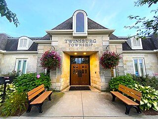
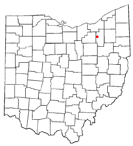
Twinsburg Township is one of the nine townships of Summit County, Ohio, United States. The 2020 census found 3,857 people in the township.

<span class="mw-page-title-main">Akron metropolitan area</span> Metropolitan area in Ohio, United States

The Akron, OH Metropolitan Statistical Area, sometimes referred to as Greater Akron, is defined by the United States Office of Management and Budget as an area consisting of two counties, Summit and Portage, in Northeast Ohio and anchored by the city of Akron. As of the 2020 census, the MSA had a population of 702,219. The Akron MSA is also part of the larger Cleveland–Akron–Canton, OH Combined Statistical Area, which has a population of 3,633,962 people as of the 2020 census, the largest metropolitan area in Ohio.

References

  1. 1 2 "US Board on Geographic Names". United States Geological Survey. October 25, 2007. Retrieved January 31, 2008.
  2. "Bath township, Summit County, Ohio - Census Bureau Profile". United States Census Bureau. Retrieved August 24, 2023.
  3. "U.S. Census website". United States Census Bureau . Retrieved January 31, 2008.
  4. "Bath Township Ohio". Bath Township Ohio. Archived from the original on September 13, 2019. Retrieved June 7, 2012.
  5. Doyle, William B. (1908). Centennial History of Summit County, Ohio and Representative Citizens. Biographical Publishing Company. p.  102.
  6. Overman, William Daniel (1958). Ohio Town Names. Akron, OH: Atlantic Press. p. 9.
  7. "BATH-AKRON-FAIRLAWN JEDD". Archived from the original on February 5, 2007. Retrieved May 11, 2007.
  8. "Ohio Formation Maps". Archived from the original on June 19, 2012. Retrieved April 25, 2005.
  9. Extension Data Center, Dept of HCRD, The Ohio State University Ohio County Profiles [ permanent dead link ]. Retrieved May 1, 2005.
  10. Bath Township Administration Contact Information Archived August 10, 2007, at the Wayback Machine , Bath Township Homepage. Accessed October 10, 2012.
  11. "Bath trustees select Vito Sinopoli as next administrator". Akron Beacon Journal online. September 23, 2012. Retrieved October 25, 2012.
  12. "Police Department Home Page". Bath Township. Archived from the original on March 25, 2005. Retrieved March 1, 2020.
  13. "Fire Department Home Page". Bath Township. Archived from the original on February 23, 2020. Retrieved March 1, 2020.
  14. Commercial Survey Company (2004). Official Street Atlas of Akron Summit and Portage Counties. Cleveland, Ohio: Commercial Survey Company. ISBN   1-879116-56-1.
  15. "Bath Nature Preserve". Archived from the original on September 16, 2007. Retrieved January 12, 2008.
  16. 1 2 Bath Nature Preserve Archived February 8, 2008, at the Wayback Machine
  17. 1 2 Hale Farm. Western Reserve Historical Society.
  18. Haidet, Ryan A. (August 15, 2014). "Tough sell? Jeffrey Dahmer boyhood home still on market". USA Today. Retrieved January 31, 2016.
  19. "Home". lebronjames.com.

Further reading