Silver Lake, Ohio | |
---|---|
Coordinates: 41°9′13″N81°27′39″W / 41.15361°N 81.46083°W | |
Country | United States |
State | Ohio |
County | Summit |
Founded | 1918 |
Incorporated | 1918 |
Government | |
• Mayor | Bernie Hovey [1] |
Area | |
• Total | 1.60 sq mi (4.15 km2) |
• Land | 1.42 sq mi (3.68 km2) |
• Water | 0.18 sq mi (0.47 km2) |
Elevation | 1,053 ft (321 m) |
Population (2020) | |
• Total | 2,516 |
• Density | 1,769.34/sq mi (682.92/km2) |
Time zone | UTC-5 (EST) |
• Summer (DST) | UTC-4 (EDT) |
ZIP code | 44224 |
Area code | 330 |
FIPS code | 39-72494 [3] |
GNIS feature ID | 1065326 [4] |
Website | http://www.villageofsilverlake.com |
Reference: [5] |
Silver Lake is a village in Summit County, Ohio, United States. The population was 2,516 at the 2020 census. It is a suburb of Akron and is part of the Akron metropolitan area. Silver Lake is between and surrounded by the cities of Stow and Cuyahoga Falls.
Beginning in 1874, the lake and the land surrounding it was a popular amusement park in the Akron area. The lake was acquired in 1874 by Ralph H. Lodge, and he subsequently also purchased the land surrounding the body of water. It was originally a picnicking and swimming area, but before it closed, the 600-acre Silver Lake Amusement Park featured animal exhibits, a roller coaster, sport facilities, a dance hall, and a hotel, becoming one of the "biggest attractions in Ohio." [6] In its prime, the Silver Lake Amusement Park received over 10,000 visitors per day. It was sold in 1917 and subdivided for residential development, leading to the incorporation of the village in 1918. [7]
Silver Lake is located at 41°9′13″N81°27′39″W / 41.15361°N 81.46083°W (41.153556, -81.460860). [8]
According to the United States Census Bureau, the village has a total area of 1.60 square miles (4.14 km2), of which 0.18 square miles (0.47 km2) is covered by water. [9]
The village includes two lakes: Silver Lake and Crystal Lake.
Census | Pop. | Note | %± |
---|---|---|---|
1920 | 120 | — | |
1930 | 478 | 298.3% | |
1940 | 642 | 34.3% | |
1950 | 1,040 | 62.0% | |
1960 | 2,655 | 155.3% | |
1970 | 3,286 | 23.8% | |
1980 | 2,915 | −11.3% | |
1990 | 3,052 | 4.7% | |
2000 | 3,019 | −1.1% | |
2010 | 2,519 | −16.6% | |
2020 | 2,516 | −0.1% | |
U.S. Decennial Census [10] |
As of the census [11] of 2010, 2,519 people, 1,004 households, and 789 families were residing in the village. The population density was 1,773.9 inhabitants per square mile (684.9/km2). The 1,066 housing units had an average density of 750.7 per square mile (289.8/km2). The racial makeup of the village was 96.9% White, 0.6% African American, 0.1% Native American, 1.5% Asian, 0.1% Pacific Islander, 0.2% from other races, and 0.6% from two or more races. Hispanics or Latinos of any race were 1.3% of the population.
Of the 1,004 households, 28.0% had children under 18 living with them, 69.9% were married couples living together, 6.3% had a female householder with no husband present, 2.4% had a male householder with no wife present, and 21.4% were not families; 19.2% of all households were made up of individuals, and 9.9% had someone living alone who was 65 or older. The average household size was 2.50, and the average family size was 2.85.
The median age in the village was 49.9 years. Its age distribution was 20.5% under 18. 5.7% from 18 to 24; 15.3% from 25 to 44; 38.9% from 45 to 64; and 19.7% were 65 years of age or older. The gender makeup of the village was 49.8% male and 50.2% female.
As of the census [3] of 2000, 3,019 people, 1,235 households, and 918 families were residing in the village. The population density was 2,129.2 inhabitants per square mile (822.1/km2). The 1,316 housing units averaged 928.1 per square mile (357.8/km2). The racial makeup of the village was 98.24% White, 0.13% African American, 0.10% Native American, 0.70% Asian, 0.17% from other races, and 0.66% from two or more races. Hispanics or Latinos of any race were 0.79% of the population.
Of the 1,235 households, 27.3% had children under 18 living with them, 68.6% were married couples living together, 4.5% had a female householder with no husband present, and 25.6% were not families. About 23.9% of all households were made up of individuals, and 17.7% had someone living alone who was 65 or older. The average household size was 2.43, and the average family size was 2.88.
In the village, the age distribution was 22.7% under 18, 3.8% from 18 to 24, 19.1% from 25 to 44, 27.2% from 45 to 64, and 27.1% who were 65 age or older. The median age was 48 years. For every 100 females, there were 89.8 males. For every 100 females age 18 and over, there were 84.4 males.
The median income for a household in the village was $70,875, and for a family was $79,286. Males had a median income of $64,265 versus $38,529 for females. The per capita income for the village was $35,614. About 1.1% of families and 2.8% of the population were below the poverty line, including none under age 18 and 6.8% of those age 65 or over.
From 1902 to 1917 the Miniature Railway at Silver Lake operated in the recreation park at Silver Lake.
Douglass Township is a civil township of Montcalm County in the U.S. state of Michigan. The population was 2,239 at the 2020 census.
Akron is a village in Tuscola County of the U.S. state of Michigan. The population was 349 at the 2020 census.
Caneadea is a town in Allegany County, New York, United States. The population was 2,238 at the 2020 census.
Cleves is a village in Miami Township, Hamilton County, Ohio, United States. Located along the Ohio River, it is a western suburb of Cincinnati. The population was 3,414 at the 2020 census.
Mowrystown is a village in Highland County, Ohio, United States. The population was 385 at the 2020 census.
Holmesville is a village in Holmes County, Ohio, United States, along Killbuck Creek. The population was 371 at the 2020 census.
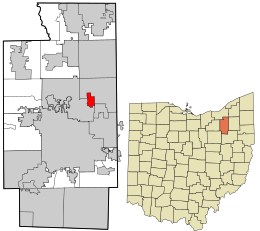
Hanover is a village in Licking County, Ohio, United States. The population was 1,270 at the 2020 census. The village lies along Ohio State Route 16.
St. Louisville is a village in Licking County, Ohio, United States, along the North Fork of the Licking River. The population was 352 at the 2020 census.
Grafton is a village in Lorain County, Ohio, United States, along the East Branch of the Black River. The population was 5,895 at the 2020 census. The Lorain Correctional Institution and several other prisons are located in and near Grafton.
Rochester is a village in Lorain County, Ohio, United States, along the West Branch of the Black River. The population was 159 at the 2020 census.
Chippewa Lake is a village in Medina County, Ohio, United States. It is located on Chippewa Lake, a natural inland lake in Ohio. The village was incorporated in 1920. The population was 654 at the 2020 census.
Adelphi is a village in Ross County, Ohio, United States. The population was 322 at the 2020 census.
Portage Lakes is a census-designated place in Summit County, Ohio, United States. The population was 6,407 at the 2020 census. A suburb directly south of Akron, the community takes its name from the encompassing Portage Lakes.
Richfield is a village in Summit County, Ohio, United States. The population was 3,729 at the 2020 census. It is located midway between Akron and Cleveland and is part of the Akron metropolitan area.
Silver Lake Township is a township in Susquehanna County, Pennsylvania, United States. The population was 1,525 at the 2020 census. The village of Brackney is in the township.
Berea is a census-designated place (CDP) in Greenville County, South Carolina, United States. The population was 14,295 at the 2010 census. It is part of the Greenville–Mauldin–Easley Metropolitan Statistical Area.
Silver Lake is a former village and now a neighborhood within the village of Salem Lakes in Kenosha County, Wisconsin, United States. The population was 2,411 at the 2010 census, when the community was still an independent village. On February 14, 2017, the village merged with the town of Salem to create the village of Salem Lakes.
North Freedom is a village along the Baraboo River in Sauk County, Wisconsin, United States. Population was 701 as reported by the 2010 census.
Mogadore is a village in Portage and Summit counties in the U.S. state of Ohio. The population was 3,811 at the 2020 census. A suburb of Akron, it is part of the Akron metropolitan area.
Machias is a census-designated place (CDP) corresponding to the central village area within the town of Machias in Washington County, Maine, United States. The population of the CDP was 1,274 at the 2010 census.