Boston, Indiana | |
---|---|
Coordinates: 39°44′28″N84°51′06″W / 39.74111°N 84.85167°W | |
Country | United States |
State | Indiana |
County | Wayne |
Township | Boston |
Area | |
• Total | 0.22 sq mi (0.58 km2) |
• Land | 0.22 sq mi (0.58 km2) |
• Water | 0.00 sq mi (0.00 km2) |
Elevation | 1,132 ft (345 m) |
Population (2020) | |
• Total | 150 |
• Density | 672.65/sq mi (259.65/km2) |
Time zone | UTC-5 (Eastern (EST)) |
• Summer (DST) | UTC-5 (EST) |
ZIP code | 47324 |
Area code | 765 |
FIPS code | 18-06652 |
GNIS ID | 2396597 [2] |
Boston is a town in Boston Township, Wayne County, Indiana, United States. [2] The population was 138 at the 2010 census.
Boston was named after Boston, Massachusetts. [3]
Boston was originally called New Boston, and under the latter name was laid out and platted in 1832. [4] The first post office in Boston was established in 1837. [5]
On June 26, 1849, a cholera outbreak began, with the first death occurring the following day. Of the 120 residents at the time, 53 residents died over the following 5 weeks. [6]
The Boston Township Council is composed of five members with a council president.[ citation needed ]
According to the 2010 census, Boston has a total area of 0.21 square miles (0.54 km2), all land. [7]
Census | Pop. | Note | %± |
---|---|---|---|
1880 | 137 | — | |
1890 | 146 | 6.6% | |
1900 | 134 | −8.2% | |
1910 | 122 | −9.0% | |
1920 | 190 | 55.7% | |
1930 | 184 | −3.2% | |
1940 | 182 | −1.1% | |
1950 | 257 | 41.2% | |
1960 | 240 | −6.6% | |
1970 | 210 | −12.5% | |
1980 | 189 | −10.0% | |
1990 | 159 | −15.9% | |
2000 | 177 | 11.3% | |
2010 | 138 | −22.0% | |
2020 | 150 | 8.7% | |
U.S. Decennial Census [8] |
As of the 2010 census, [9] there were 138 people, 60 households, and 41 families living in the town. The population density was 657.1 inhabitants per square mile (253.7/km2). There were 67 housing units at an average density of 319.0 per square mile (123.2/km2). The racial makeup of the town was 97.8% White, 0.7% Native American, and 1.4% Asian.
There were 60 households, of which 30.0% had children under the age of 18 living with them, 58.3% were married couples living together, 6.7% had a female householder with no husband present, 3.3% had a male householder with no wife present, and 31.7% were non-families. 25.0% of all households were made up of individuals, and 11.7% had someone living alone who was 65 years of age or older. The average household size was 2.30 and the average family size was 2.68.
The median age in the town was 42 years. 22.5% of residents were under the age of 18; 5% were between the ages of 18 and 24; 26.7% were from 25 to 44; 26% were from 45 to 64; and 19.6% were 65 years of age or older. The gender makeup of the town was 52.2% male and 47.8% female.
As of the 2000 census, [10] there were 177 people, 67 households, and 52 families living in the town. The population density was 838.5 inhabitants per square mile (323.7/km2). There were 70 housing units at an average density of 331.6 per square mile (128.0/km2). The racial makeup of the town was 99.44% White, and 0.56% from two or more races. Hispanic or Latino of any race were 0.56% of the population.
There were 67 households, out of which 37.3% had children under the age of 18 living with them, 68.7% were married couples living together, 7.5% had a female householder with no husband present, and 20.9% were non-families. 17.9% of all households were made up of individuals, and 9.0% had someone living alone who was 65 years of age or older. The average household size was 2.64 and the average family size was 3.02.
In the town, the population was spread out, with 24.9% under the age of 18, 8.5% from 18 to 24, 34.5% from 25 to 44, 22.0% from 45 to 64, and 10.2% who were 65 years of age or older. The median age was 35 years. For every 100 females, there were 98.9 males. For every 100 females age 18 and over, there were 92.8 males.
The median income for a household in the town was $50,625, and the median income for a family was $46,875. Males had a median income of $35,625 versus $20,179 for females. The per capita income for the town was $19,852. None of the families and 2.5% of the population were living below the poverty line.
Richmond Municipal Airport is located near Boston.
West Harrison is a town in Harrison Township, Dearborn County, Indiana, United States. The population was 289 at the 2010 census.
Chesterfield is a town in the U.S. state of Indiana which lies in Union Township, Madison County, and Salem Township, Delaware County. The population was 2,490 at the 2020 census. It is part of the Indianapolis–Carmel–Anderson metropolitan statistical area.
Kingman is a town in Millcreek Township, Fountain County, Indiana, United States. The population was 511 at the 2010 census.
Akron is a town in Henry Township, Fulton County, Indiana, United States. The population was 1,167 at the 2010 census.
Kewanna is a town in Union Township, Fulton County, Indiana, United States. The population was 613 at the 2010 census.
Upland is a town in Jefferson Township, Grant County, Indiana, United States. The population was 3,821 at the 2020 census. It is the home of Taylor University, a Christian college.
McCordsville is a town in Vernon Township, Hancock County, Indiana, United States. The town is a fast-growing suburb of Indianapolis with an estimated population of 8,592 in 2020.
Medora is a town in Carr Township, Jackson County, Indiana, United States. The population was 693 at the 2010 census.
Burket is a town in Seward Township, Kosciusko County, in the U.S. state of Indiana. The population was 195 at the 2010 census.
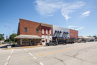
Leesburg is a town in Plain Township, Kosciusko County, in the U.S. state of Indiana. The population was 555 at the 2010 Census. The town of Leesburg was laid out in 1833 by Levi Lee. It includes the Leesburg Historic District.
Mentone is a town in Harrison and Franklin townships, Kosciusko County, in the U.S. state of Indiana. Mentone is the self-proclaimed "Egg Basket of the Midwest" because of prolific commercial egg production in the area, and holds an Egg Festival annually in early June to celebrate its heritage. A large concrete egg stands near the town center and is considered locally to be the "Largest Egg in the World". The Lawrence D. Bell Aircraft Museum, is located within the town limits. The Popular Rotorcraft Association has its home at the PRA Mentone Airport C92) and is home to their annual fly-in convention.
Macy is a town in Allen Township, Miami County, in the U.S. state of Indiana. The population was 199 at the 2020 census.
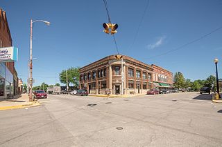
Parker City is a town in Monroe Township, Randolph County, in the U.S. state of Indiana. The population was 1,419 at the 2010 census.
Napoleon is a town in Jackson Township, Ripley County, in the U.S. state of Indiana. The population was 234 at the 2010 census.
Campbellsburg is a town in Brown Township, Washington County, in the U.S. state of Indiana. The population was 585 at the 2010 census.
Hardinsburg is a census-designated place in Posey Township, Washington County, in the U.S. state of Indiana. The population was 222 at the 2020 census.
Saltillo is a town in Brown Township, Washington County, in the U.S. state of Indiana. The population was 92 at the 2010 census.
Vera Cruz is a town in Harrison Township, Wells County, in the U.S. state of Indiana. The population was 80 at the 2010 census.
Haynesville is a town in Aroostook County, Maine, United States. The population was 97 at the 2020 census.
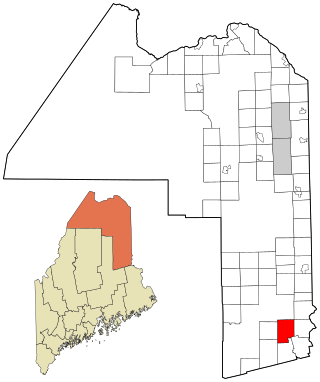
Princeton is a town in Washington County, Maine, United States. The town was named after Princeton, Massachusetts. The population was 745 at the 2020 census.