Greens Fork, Indiana

Last updated
Greens Fork, Indiana
Greensfork, Indiana.jpg
Wayne County Indiana Incorporated and Unincorporated areas Greens Fork Highlighted 1829754.svg
Location of Greens Fork in Wayne County, Indiana.
Coordinates: 39°53′30″N85°02′28″W / 39.89167°N 85.04111°W / 39.89167; -85.04111
Country United States
State Indiana
County Wayne
Township Clay
Area
[1]
  Total0.14 sq mi (0.36 km2)
  Land0.14 sq mi (0.36 km2)
  Water0.00 sq mi (0.00 km2)
Elevation
[2]
1,007 ft (307 m)
Population
 (2020)
  Total335
  Density2,392.86/sq mi (925.50/km2)
Time zone UTC-5 (Eastern (EST))
  Summer (DST) UTC-5 (EST)
ZIP code
47345
Area code 765
FIPS code 18-29754 [3]
GNIS feature ID2396974 [2]

Greens Fork is a town in Clay Township, Wayne County, in the U.S. state of Indiana. [2] The population was 423 at the 2010 census.

Contents

Pearl Street Greens Fork from west.jpg
Pearl Street

Geography

According to the 2010 census, the town has a total area of 0.16 square miles (0.41 km2), all land. [4]

Demographics

Historical population
CensusPop.Note
1920 380
1930 333−12.4%
1940 41324.0%
1950 4130.0%
1960 47414.8%
1970 444−6.3%
1980 426−4.1%
1990 416−2.3%
2000 371−10.8%
2010 42314.0%
2020 335−20.8%
U.S. Decennial Census [5]

2010 census

As of the census [6] of 2010, there were 423 people, 147 households, and 113 families living in the town. The population density was 2,643.8 inhabitants per square mile (1,020.8/km2). There were 161 housing units at an average density of 1,006.3 per square mile (388.5/km2). The racial makeup of the town was 99.3% White, 0.2% Native American, 0.2% Asian, and 0.2% from two or more races.

There were 147 households, of which 38.8% had children under the age of 18 living with them, 51.7% were married couples living together, 20.4% had a female householder with no husband present, 4.8% had a male householder with no wife present, and 23.1% were non-families. 19.0% of all households were made up of individuals, and 4.1% had someone living alone who was 65 years of age or older. The average household size was 2.88 and the average family size was 3.25.

The median age in the town was 37.2 years. 27.2% of residents were under the age of 18; 8.3% were between the ages of 18 and 24; 25% were from 25 to 44; 25.5% were from 45 to 64; and 13.9% were 65 years of age or older. The gender makeup of the town was 46.8% male and 53.2% female.

2000 census

As of the census [3] of 2000, there were 371 people, 136 households, and 102 families living in the town. The population density was 2,462.8 inhabitants per square mile (950.9/km2). There were 147 housing units at an average density of 975.8 per square mile (376.8/km2). The racial makeup of the town was 97.57% White, 0.54% African American, 0.27% Asian, and 1.62% from two or more races. Hispanic or Latino of any race were 0.81% of the population.

There were 136 households, out of which 36.8% had children under the age of 18 living with them, 61.8% were married couples living together, 12.5% had a female householder with no husband present, and 25.0% were non-families. 20.6% of all households were made up of individuals, and 10.3% had someone living alone who was 65 years of age or older. The average household size was 2.73 and the average family size was 3.22.

In the town, the population was spread out, with 27.8% under the age of 18, 10.5% from 18 to 24, 28.6% from 25 to 44, 21.6% from 45 to 64, and 11.6% who were 65 years of age or older. The median age was 35 years. For every 100 females there were 98.4 males. For every 100 females age 18 and over, there were 90.1 males.

The median income for a household in the town was $36,406, and the median income for a family was $36,786. Males had a median income of $29,583 versus $25,357 for females. The per capita income for the town was $13,605. About 7.3% of families and 8.2% of the population were below the poverty line, including 13.9% of those under age 18 and 5.1% of those age 65 or over.

History

The town of Greens Fork derives its name from the Greens Fork river on which it is situated. [7] Both the river and the town get their name from a Delaware Indian named Johnny Green. [8] The Greens Fork post office has been in operation since 1828. [9]

In 2002, the town constructed a central wastewater treatment plant, sanitary sewer collection system and lift station to pump sewage to the treatment plant. The plant is rated at 40,000 gallons per day, and discharges its treated water to the Greens Fork River.

Notable people

Related Research Articles

<span class="mw-page-title-main">Ambia, Indiana</span> Town in Indiana, United States

Ambia is a town in Hickory Grove Township, Benton County, Indiana, United States. The population was 239 at the 2010 census. It is part of the Lafayette, Indiana Metropolitan Statistical Area.

<span class="mw-page-title-main">Milltown, Indiana</span> Town in Indiana, United States

Milltown is a town in Whiskey Run Township in Crawford County, Indiana and in Blue River and Spencer townships in Harrison County. The population was 818 at the time of the 2010 census.

<span class="mw-page-title-main">St. Leon, Indiana</span> Town in Indiana, United States

St. Leon or Saint Leon is a town in Kelso Township, Dearborn County, Indiana, United States. The population was 678 at the 2010 census.

<span class="mw-page-title-main">St. Paul, Indiana</span> Town in Indiana, United States

St. Paul or Saint Paul is a small town on the border of Decatur and Shelby counties in the U.S. state of Indiana. The population was 1,031 at the 2010 census.

<span class="mw-page-title-main">Albany, Indiana</span> Town in Indiana, United States

Albany is a town in Delaware and Randolph counties in the U.S. state of Indiana, along the Mississinewa River. The population was 2,295 at the 2020 census. It is part of the Muncie, IN Metropolitan Statistical Area.

<span class="mw-page-title-main">Veedersburg, Indiana</span> Town in Indiana, United States

Veedersburg is a town in Van Buren Township, Fountain County, Indiana, United States. The population was 2,180 at the 2010 census.

<span class="mw-page-title-main">Stilesville, Indiana</span> Town in Indiana, United States

Stilesville is a town in Franklin Township, Hendricks County, Indiana, United States. The population was 316 at the 2010 Census.

<span class="mw-page-title-main">Brownstown, Indiana</span> Town in Indiana, United States

Brownstown is a town within Brownstown Township and the county seat of Jackson County, Indiana, United States. The population was 2,947 at the 2010 census. It was named for Jacob Brown, a general of the War of 1812.

<span class="mw-page-title-main">River Forest, Indiana</span> Town in Indiana, United States

River Forest is a town in Anderson Township, Madison County, Indiana, United States. It is part of the Indianapolis–Carmel–Anderson metropolitan statistical area. The population was 26 at the 2020 census.

<span class="mw-page-title-main">Woodlawn Heights, Indiana</span> Town in Indiana, United States

Woodlawn Heights is a town in Anderson Township, Madison County, Indiana, United States. It is part of the Indianapolis–Carmel–Anderson metropolitan statistical area. The population was 91 at the 2020 census.

<span class="mw-page-title-main">Shoals, Indiana</span> Town in Indiana, United States

Shoals is a town in Center and Halbert townships and the county seat of Martin County, in the U.S. state of Indiana. The population was 677 at the 2020 census, down from 756 in 2010.

<span class="mw-page-title-main">Waynetown, Indiana</span> Town in Indiana, United States

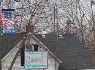
Waynetown is a town in Wayne Township, Montgomery County, in the U.S. state of Indiana. The population was 960 at the 2020 census.

<span class="mw-page-title-main">Bethany, Indiana</span> Town in Indiana, United States

Bethany is a town in Clay Township, Morgan County, in the U.S. state of Indiana. The population was 95 at the 2020 census.

<span class="mw-page-title-main">Paragon, Indiana</span> Town in Indiana, United States

Paragon is a town in Ray Township, Morgan County, in the U.S. state of Indiana. The population was 556 at the 2020 census, down from 659 in 2010.

<span class="mw-page-title-main">Clear Lake, Indiana</span> Town in Indiana, United States

Clear Lake is a town located in the northeast corner of Steuben County, Indiana, in Clear Lake Township. As such, is the northeasternmost community in the State of Indiana. The population was 339 at the 2010 census.

<span class="mw-page-title-main">Fredericksburg, Indiana</span> Census-designated place in Indiana, United States

Fredericksburg is an unincorporated community in Posey Township, Washington County, in the U.S. state of Indiana. The population was 85 at the 2010 census, at the time it was a town.

<span class="mw-page-title-main">Sand Fork, West Virginia</span> Town in West Virginia, United States

Sand Fork is a town in Gilmer County, West Virginia, United States. The population was 182 at the 2020 census. It is located along the Little Kanawha River, at the mouth of the Sand Fork.

<span class="mw-page-title-main">Northfork, West Virginia</span> Town in West Virginia, United States

Northfork is a town in McDowell County, West Virginia, United States, located on U.S. Route 52 between Welch and Bluefield.

<span class="mw-page-title-main">South Fork, Wisconsin</span> Town in Wisconsin, United States

South Fork is a town in Rusk County, Wisconsin, United States. The population was 120 at the 2000 census. The unincorporated community of South Fork is located in the town.

<span class="mw-page-title-main">North Crows Nest, Indiana</span> Town in Indiana, United States

North Crows Nest is a town in Washington Township, Marion County, Indiana, United States. It is approximately 7 miles (11 km) north of downtown Indianapolis. The population was 44 at the 2020 census. It has existed as an "included town" since 1970, when it was incorporated into Indianapolis as part of Unigov. It is part of Indianapolis, but retains town governmental powers under IC 36-3-1-11.

References

  1. "2020 U.S. Gazetteer Files". United States Census Bureau. Retrieved March 16, 2022.
  2. 1 2 3 U.S. Geological Survey Geographic Names Information System: Greens Fork, Indiana
  3. 1 2 "U.S. Census website". United States Census Bureau . Retrieved 2008-01-31.
  4. "Places: Indiana". 2010 Census Gazetteer Files. United States Census Bureau. Archived from the original on 2014-05-17. Retrieved 2012-04-21.
  5. "Census of Population and Housing". Census.gov. Retrieved June 4, 2015.
  6. "U.S. Census website". United States Census Bureau . Retrieved 2012-12-11.
  7. "Profile for Greens Fork, IN". ePodunk . Retrieved July 7, 2016.
  8. Beers, Jayne. "Early History of Greens Fork, Indiana". Waynet.
  9. "Wayne County". Jim Forte Postal History. Retrieved July 7, 2016.
  10. "Junior Saffer". Peach Basket Society. September 2, 2015. Retrieved May 27, 2019.