Spring Grove, Indiana

Last updated

Spring Grove, Indiana
Spring Grove sign.jpg
Wayne County Indiana Incorporated and Unincorporated areas Spring Grove Highlighted 1872206.svg
Location of Spring Grove in Wayne County, Indiana.
Coordinates: 39°50′50″N84°53′28″W / 39.84722°N 84.89111°W / 39.84722; -84.89111
Country United States
State Indiana
County Wayne
Township Wayne
Area
[1]
  Total0.30 sq mi (0.79 km2)
  Land0.30 sq mi (0.79 km2)
  Water0.00 sq mi (0.00 km2)
Elevation
[2]
991 ft (302 m)
Population
 (2020)
  Total332
  Density1,092.11/sq mi (421.97/km2)
Time zone UTC-5 (Eastern (EST))
  Summer (DST) UTC-4 (EDT)
ZIP code
47374
Area code 765
FIPS code 18-72206 [3]
GNIS feature ID2397673 [2]

Spring Grove is a town in Wayne Township, Wayne County, in the U.S. state of Indiana. [2] The population was 344 at the 2010 census.

Contents

Geography

Spring Grove, Indiana Spring Grove, Indiana.jpg
Spring Grove, Indiana

According to the 2010 census, Spring Grove has a total area of 0.321 square miles (0.83 km2), of which 0.32 square miles (0.83 km2) (or 99.69%) is land and 0.001 square miles (0.00 km2) (or 0.31%) is water. [4]

Demographics

Historical population
CensusPop.Note
1890 99
1900 11314.1%
1910 1228.0%
1920 76−37.7%
1930 191151.3%
1940 23724.1%
1950 33340.5%
1960 47141.4%
1970 437−7.2%
1980 4697.3%
1990 420−10.4%
2000 386−8.1%
2010 344−10.9%
2020 332−3.5%
U.S. Decennial Census [5]

2010 census

As of the census [6] of 2010, there were 344 people, 117 households, and 77 families living in the town. The population density was 1,075.0 inhabitants per square mile (415.1/km2). There were 133 housing units at an average density of 415.6 per square mile (160.5/km2). The racial makeup of the town was 89.2% White, 5.5% African American, 1.2% Asian, and 4.1% from two or more races. Hispanic or Latino of any race were 0.9% of the population.

There were 117 households, of which 24.8% had children under the age of 18 living with them, 51.3% were married couples living together, 12.0% had a female householder with no husband present, 2.6% had a male householder with no wife present, and 34.2% were non-families. 30.8% of all households were made up of individuals, and 10.3% had someone living alone who was 65 years of age or older. The average household size was 2.17 and the average family size was 2.70.

The median age in the town was 58.4 years. 15.4% of residents were under the age of 18; 3.8% were between the ages of 18 and 24; 15.5% were from 25 to 44; 24.7% were from 45 to 64; and 40.7% were 65 years of age or older. The gender makeup of the town was 42.4% male and 57.6% female.

2000 census

As of the census [3] of 2000, there were 386 people, 132 households, and 86 families living in the town. The population density was 1,216.8 inhabitants per square mile (469.8/km2). There were 137 housing units at an average density of 431.9 per square mile (166.8/km2). The racial makeup of the town was 94.82% White, 2.85% African American, 1.55% Asian, 0.26% from other races, and 0.52% from two or more races.

There were 132 households, out of which 18.9% had children under the age of 18 living with them, 55.3% were married couples living together, 8.3% had a female householder with no husband present, and 34.8% were non-families. 28.8% of all households were made up of individuals, and 14.4% had someone living alone who was 65 years of age or older. The average household size was 2.12 and the average family size was 2.55.

In the town, the population was spread out, with 11.9% under the age of 18, 3.1% from 18 to 24, 16.1% from 25 to 44, 29.8% from 45 to 64, and 39.1% who were 65 years of age or older. The median age was 57 years. For every 100 females, there were 70.0 males. For every 100 females age 18 and over, there were 67.5 males.

The median income for a household in the town was $45,781, and the median income for a family was $51,500. Males had a median income of $38,750 versus $21,250 for females. The per capita income for the town was $24,705. About 7.8% of families and 10.1% of the population were below the poverty line, including 31.4% of those under age 18 and none of those age 65 or over.

Related Research Articles

<span class="mw-page-title-main">Eagle Lake, Maine</span> Town in the state of Maine, United States

Eagle Lake is a town in Aroostook County, Maine, United States. The population was 772 at the 2020 census. The town was named by a body of troops heading from Bangor to the Aroostook War for the many eagles that they saw around the lake. A total of 49.0% of the population speaks French, reflecting a trend in Northeastern Maine.

<span class="mw-page-title-main">Littleton, Maine</span> Town in the state of Maine, United States

Littleton is a town in Aroostook County, Maine, United States. The population was 997 at the 2020 census.

<span class="mw-page-title-main">Mapleton, Maine</span> Town in the state of Maine, United States

Mapleton is a town in Aroostook County, Maine, United States. The population was 1,886 at the 2020 census.

<span class="mw-page-title-main">Merrill, Maine</span> Town in the state of Maine, United States

Merrill is a town in Aroostook County, Maine, United States. The population was 208 at the 2020 census.

<span class="mw-page-title-main">New Canada, Maine</span> Town in the state of Maine, United States

New Canada is a town in Aroostook County, Maine, United States. The population was 310 at the 2020 census.

<span class="mw-page-title-main">Oakfield, Maine</span> Town in the state of Maine, United States

Oakfield is a town in Aroostook County, Maine, United States. The population was 661 at the 2020 census. The village of Oakfield, listed as a census-designated place, is in the northwestern corner of the town.

<span class="mw-page-title-main">Perham, Maine</span> Town in the state of Maine, United States

Perham is a town in Aroostook County, Maine, United States. The population was 371 at the 2020 census. The town was named after Maine's 33rd governor, Sidney Perham.

<span class="mw-page-title-main">Sherman, Maine</span> Town in the state of Maine, United States

Sherman is a town in Aroostook County, Maine, United States. The population was 815 at the 2020 census.

<span class="mw-page-title-main">Stockholm, Maine</span> Town in the state of Maine, United States

Stockholm is a town in Aroostook County, Maine, United States. The population was 250 at the 2020 census.

<span class="mw-page-title-main">Wallagrass, Maine</span> Town in the state of Maine, United States

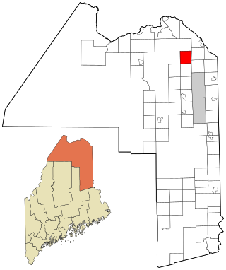
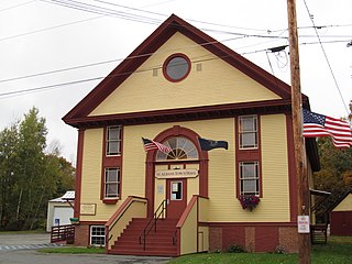
Wallagrass is a town in Aroostook County, Maine, United States. The population was 519 at the 2020 census.

<span class="mw-page-title-main">Westfield, Maine</span> Town in the state of Maine, United States

Westfield is a town in Aroostook County, Maine, United States. The population was 455 at the 2020 census.

<span class="mw-page-title-main">Vienna, Maine</span> Town in the state of Maine, United States

Vienna is a town in Kennebec County, Maine, United States. The population was 578 at the 2020 census.

Bradley is a town in Penobscot County, Maine, United States. It is part of the Bangor Metropolitan Statistical Area. The population was 1,532 at the 2020 census. The village of Bradley is in the northwestern corner of the town.

Plymouth is a town in Penobscot County, Maine, United States. The population was 1,325 at the 2020 census.

Detroit is a town in Somerset County, Maine, United States. The population was 885 at the 2020 census.

Meddybemps is a town in Washington County, Maine, United States. The population was 139 at the 2020 census.

<span class="mw-page-title-main">Bancroft, West Virginia</span> Town in West Virginia, United States

Bancroft is a town in Putnam County, West Virginia, United States, along the Kanawha River. The population was 389 at the 2020 census. It is part of the Huntington–Ashland metropolitan area.

<span class="mw-page-title-main">Pine Grove, West Virginia</span> Town in West Virginia, United States

Pine Grove is a town in Wetzel County, West Virginia, United States. The population was 363 at the 2020 census. The community was named for a grove of pine trees near the original town site.

<span class="mw-page-title-main">North Hills, West Virginia</span> Town in West Virginia, United States

North Hills is a town in Wood County, West Virginia, United States. It is a suburb of Parkersburg. The population was 837 at the 2020 census. North Hills was incorporated on February 15, 1979.

<span class="mw-page-title-main">St. Albans, Maine</span> Town in the state of Maine, United States

St. Albans is a town in Somerset County, Maine, United States. The population was 2,045 at the 2020 census.

References

  1. "2020 U.S. Gazetteer Files". United States Census Bureau. Retrieved March 16, 2022.
  2. 1 2 3 U.S. Geological Survey Geographic Names Information System: Spring Grove, Indiana
  3. 1 2 "U.S. Census website". United States Census Bureau . Retrieved January 31, 2008.
  4. "G001 - Geographic Identifiers - 2010 Census Summary File 1". United States Census Bureau. Archived from the original on February 13, 2020. Retrieved July 25, 2015.
  5. "Census of Population and Housing". Census.gov. Retrieved June 4, 2015.
  6. "U.S. Census website". United States Census Bureau . Retrieved December 11, 2012.