East Germantown, Indiana

Last updated

East Germantown, Indiana
Wayne County Indiana Incorporated and Unincorporated areas East Germantown Highlighted 1819756.svg
Location of East Germantown in Wayne County, Indiana.
Coordinates: 39°48′47″N85°08′13″W / 39.81306°N 85.13694°W / 39.81306; -85.13694
Country United States
State Indiana
County Wayne
Township Jackson
Area
[1]
  Total0.12 sq mi (0.30 km2)
  Land0.12 sq mi (0.30 km2)
  Water0.00 sq mi (0.00 km2)
Elevation
[2]
951 ft (290 m)
Population
 (2020)
  Total261
  Density2,230.77/sq mi (863.62/km2)
Time zone UTC-5 (Eastern (EST))
  Summer (DST) UTC-5 (EST)
ZIP code
47327
Area code 765
FIPS code 18-19756 [3]
GNIS feature ID2396917 [2]

East Germantown is a town in Jackson Township, Wayne County, in the U.S. state of Indiana. [2] The population was 410 at the 2010 census.

Contents

History

East Germantown was originally called Georgetown, and under the latter name was laid out and platted in 1827. [4]

The East Germantown Civil War Band was assigned to the 12th Indiana Volunteer Infantry Regiment in 1862. [5] [6]

A post office operated from March 31, 1846, until August 4, 1917, under the name of East Germantown, when its name officially changed to Pershing due to events surrounding World War I. [7] [8] [9] [10]

A resolution to change the town name from East Germantown to Pershing, in honor of General Pershing, was introduced by the town board. A faction campaigned the day before the name-change vote by telling people that since their deeds mentioned "East Germantown", changing to "Pershing" would invalidate their ownership. [8] Ernest G. Lamott (1911–1980), [11] secretary-treasurer of the town board at the time, said the vote went for "East Germantown" since voters had no way of proving or disproving this assertion in the hours before the election. [8]

The postmaster in 1917, Frank Sipe, succeeded in getting the post office name changed to "Pershing". However, the railroad continued with the name East Germantown since there is another Pershing, an unincorporated community, in Fulton County. [8]

The local Pershing Elementary School at 519 Queen Street is now the administrative offices for the Western Wayne School Corporation. [12]

Geography

According to the 2010 census, East Germantown has a total area of 0.13 square miles (0.34 km2), all land. [13]

Demographics

Historical population
CensusPop.Note
1860 465
1870 53615.3%
1880 451−15.9%
1890 338−25.1%
1900 305−9.8%
1910 302−1.0%
1920 267−11.6%
1930 2919.0%
1940 3054.8%
1950 38927.5%
1960 367−5.7%
1970 44721.8%
1980 438−2.0%
1990 372−15.1%
2000 243−34.7%
2010 41068.7%
2020 261−36.3%
U.S. Decennial Census [14]

2010 census

As of the census [15] of 2010, there were 410 people, 155 households, and 121 families living in the town. The population density was 3,153.8 inhabitants per square mile (1,217.7/km2). There were 174 housing units at an average density of 1,338.5 per square mile (516.8/km2). The racial makeup of the town was 97.8% White, 0.2% African American, 0.2% Native American, 0.2% Asian, 0.7% from other races, and 0.7% from two or more races. Hispanic or Latino of any race were 0.7% of the population.

There were 155 households, of which 37.4% had children under the age of 18 living with them, 54.8% were married couples living together, 16.1% had a female householder with no husband present, 7.1% had a male householder with no wife present, and 21.9% were non-families. 16.8% of all households were made up of individuals, and 7.7% had someone living alone who was 65 years of age or older. The average household size was 2.65 and the average family size was 2.92.

The median age in the town was 39.4 years. 23.4% of residents were under the age of 18; 9.5% were between the ages of 18 and 24; 25.4% were from 25 to 44; 26.1% were from 45 to 64; and 15.6% were 65 years of age or older. The gender makeup of the town was 48.5% male and 51.5% female.

2000 census

As of the census [3] of 2000, there were 243 people, 95 households, and 72 families living in the town. The population density was 1,913.2 inhabitants per square mile (738.7/km2). There were 103 housing units at an average density of 810.9 per square mile (313.1/km2). The racial makeup of the town was 100.00% White. Hispanic or Latino of any race were 0.82% of the population.

There were 95 households, out of which 37.9% had children under the age of 18 living with them, 61.1% were married couples living together, 9.5% had a female householder with no husband present, and 23.2% were non-families. 23.2% of all households were made up of individuals, and 12.6% had someone living alone who was 65 years of age or older. The average household size was 2.56 and the average family size was 2.95.

In the town, the population was spread out, with 28.4% under the age of 18, 4.1% from 18 to 24, 29.2% from 25 to 44, 26.7% from 45 to 64, and 11.5% who were 65 years of age or older. The median age was 38 years. For every 100 females, there were 94.4 males. For every 100 females age 18 and over, there were 93.3 males.

The median income for a household in the town was $30,714, and the median income for a family was $35,000. Males had a median income of $31,250 versus $19,063 for females. The per capita income for the town was $12,827. About 15.0% of families and 15.3% of the population were below the poverty line, including 15.0% of those under the age of eighteen and 37.5% of those 65 or over.

Related Research Articles

<span class="mw-page-title-main">Grabill, Indiana</span> Town in Indiana, United States

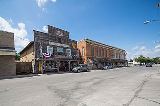
Grabill is a town in Cedar Creek Township, Allen County, Indiana, United States. The population was 1,053 at the 2010 census. Today it is known for the presence of antique stores and Amish farms. An incorporated town, Grabill has two community parks within the corporate limits.

<span class="mw-page-title-main">Chesterfield, Indiana</span> Town in Indiana, United States

Chesterfield is a town in the U.S. state of Indiana which lies in Union Township, Madison County, and Salem Township, Delaware County. The population was 2,490 at the 2020 census. It is part of the Indianapolis–Carmel–Anderson metropolitan statistical area.

<span class="mw-page-title-main">Upland, Indiana</span> Town in Indiana, United States

Upland is a town in Jefferson Township, Grant County, Indiana, United States. The population was 3,821 at the 2020 census. It is the home of Taylor University, a Christian college.

<span class="mw-page-title-main">Hamlet, Indiana</span> Town in Starke County, Indiana, United States

Hamlet is a town in Davis and Oregon Townships, Starke County, in the U.S. state of Indiana. The population was 800 as of the 2010 census.

<span class="mw-page-title-main">Kempton, Indiana</span> Town in Indiana, United States

Kempton is a town in Jefferson Township, Tipton County, in the U.S. state of Indiana. The population was 335 at the 2010 census. It is part of the Kokomo, Indiana Metropolitan Statistical Area.

<span class="mw-page-title-main">Sharpsville, Indiana</span> Town in Indiana, United States

Sharpsville is a town in Liberty Township, Tipton County, in the U.S. state of Indiana. The community is part of the Kokomo, Indiana Metropolitan Statistical Area. As of the 2010 census, Sharpsville's population is 607.

<span class="mw-page-title-main">Windfall, Indiana</span> Town in Indiana, United States

Windfall is a town in Wildcat Township, Tipton County, in the U.S. state of Indiana. It is part of the Kokomo, Indiana, Metropolitan Statistical Area. Windfall's population was 697 as of the 2021 census.

<span class="mw-page-title-main">Boston, Indiana</span> Town in Indiana, United States

Boston is a town in Boston Township, Wayne County, Indiana, United States. The population was 138 at the 2010 census.

<span class="mw-page-title-main">Centerville, Indiana</span> Town in Indiana, United States

Centerville is a town in Center Township, Wayne County, in the U.S. state of Indiana. The population was 2,552 at the 2010 United States Census.

<span class="mw-page-title-main">Dublin, Indiana</span> Town in Indiana, United States

Dublin is a town in Jackson Township, Wayne County, in the U.S. state of Indiana. The population was 679 at the 2020 census.

<span class="mw-page-title-main">Economy, Indiana</span> Town in Indiana, United States

Economy is a town in Perry Township, Wayne County, in the U.S. state of Indiana. The population was 173 at the 2021 census.

<span class="mw-page-title-main">Fountain City, Indiana</span> Town in Indiana, United States

Fountain City, formerly Newport, is a town in New Garden Township, Wayne County, in the U.S. state of Indiana. The population was 796 at the 2010 census.

<span class="mw-page-title-main">Greens Fork, Indiana</span> Town in Indiana, United States

Greens Fork is a town in Clay Township, Wayne County, in the U.S. state of Indiana. The population was 423 at the 2010 census.

<span class="mw-page-title-main">Milton, Indiana</span> Town in Indiana, United States

Milton is a town in Washington Township, Wayne County, in the U.S. state of Indiana. The population was 490 at the 2010 census.

<span class="mw-page-title-main">Spring Grove, Indiana</span> Town in Indiana, United States

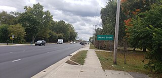
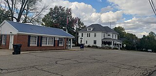
Spring Grove is a town in Wayne Township, Wayne County, in the U.S. state of Indiana. The population was 344 at the 2010 census.

<span class="mw-page-title-main">Whitewater, Indiana</span> Town in Indiana, United States

Whitewater is a town in Franklin Township, Wayne County, in the U.S. state of Indiana. The population was 83 at the 2010 census.

<span class="mw-page-title-main">Ossian, Indiana</span> Town in Indiana, United States

Ossian is a town in Jefferson Township, Wells County, in the U.S. state of Indiana. The town was named after Ossian, the narrator of a cycle of epic poems by the Scottish poet James Macpherson. The population was 3,289 at the 2010 census.

<span class="mw-page-title-main">Germantown, Ohio</span> City in Ohio, United States

Germantown is a city in Montgomery County, Ohio, United States. The population was 5,796 at the 2020 census. A part of the Dayton metropolitan area, Germantown was founded by German Americans from Pennsylvania and was once home to a cigar industry.

<span class="mw-page-title-main">Germantown, Kentucky</span> City in Kentucky, United States

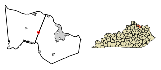
Germantown is a home rule-class city in Bracken and Mason counties in the U.S. state of Kentucky. The population was 146 at the 2020 census.

Germantown is a census-designated place (CDP) in the town of Germantown in Columbia County, New York, United States, on the east side of the Hudson River. The population of the CDP was 1,121 at the 2020 census, out of a total town population of 1,936.

References

  1. "2020 U.S. Gazetteer Files". United States Census Bureau. Retrieved March 16, 2022.
  2. 1 2 3 U.S. Geological Survey Geographic Names Information System: East Germantown, Indiana
  3. 1 2 "U.S. Census website". United States Census Bureau . Retrieved January 31, 2008.
  4. Young, Andrew White (1872). History of Wayne County, Indiana, from Its First Settlement to the Present Time. R. Clarke & Company. pp.  244–245.
  5. East Germantown Civil War Band. Indiana Historical Bureau. Accessed April 27, 2023.
  6. 12th Regiment, Indiana Infantry, Battle Unit Details. National Park Service. Accessed April 27, 2023.
  7. History of Northeastern Wayne County, Indiana. Bicentennial Commission of Old Newport Area. Unigraphic, 1976.
  8. 1 2 3 4 Interview. By Max Knight, reporter. Palladium-Item Newspaper. Richmond, Indiana. Sunday, July 19, 1959. Page 9. Accessed via paid subscription on April 27, 2023.
  9. East Germantown or Pershing, Indiana. Waynet.org. Accessed April 27, 2023.
  10. "Wayne County". Jim Forte Postal History. Archived from the original on September 14, 2005. Retrieved July 7, 2016.
  11. Ernest Lamott in the U.S., Social Security Death Index, 1935-2014. Accessed via ancestry.com paid subscription site April 27, 2023.
  12. Western Wayne Schools: Contact Page. Accessed April 27, 2023.
  13. "G001 - Geographic Identifiers - 2010 Census Summary File 1". United States Census Bureau. Archived from the original on February 13, 2020. Retrieved July 16, 2015.
  14. "Census of Population and Housing". Census.gov. Retrieved June 4, 2015.
  15. "U.S. Census website". United States Census Bureau . Retrieved December 11, 2012.