Bunceton, Missouri

Last updated

Bunceton, Missouri
Bunceton, Missouri (2015).jpg
Main Street in Bunceton
Cooper County Missouri Incorporated and Unincorporated areas Bunceton Highlighted.svg
Location of Bunceton, Missouri
Coordinates: 38°47′22″N92°47′57″W / 38.78944°N 92.79917°W / 38.78944; -92.79917 [1]
Country United States
State Missouri
County Cooper
Area
[2]
  Total0.95 sq mi (2.45 km2)
  Land0.94 sq mi (2.45 km2)
  Water0.00 sq mi (0.01 km2)
Elevation
[1]
807 ft (246 m)
Population
 (2020)
  Total334
  Density353.81/sq mi (136.57/km2)
Time zone UTC-6 (Central (CST))
  Summer (DST) UTC-5 (CDT)
ZIP code
65237
Area code 660
FIPS code 29-09658 [3]
GNIS feature ID2393461 [1]

Bunceton is a city in Cooper County, Missouri, United States. The population was 354 at the 2010 census.

Contents

History

Bunceton was laid out and platted in 1868. [4] The city was named for Harvey Bunce, an early county resident. [5] A post office has been in operation at Bunceton since 1868. [6] In 1980, Bunceton elected the United States' first openly gay mayor, Gerald Ulrich. [7]

Geography

The town is located on Missouri Route J, three miles east of Missouri Route 5. Bunceton is on the Stevens Branch tributary of Petite Saline Creek. [8]

According to the United States Census Bureau, the city has a total area of 0.94 square miles (2.43 km2), all land. [9]

Demographics

Historical population
CensusPop.Note
1890 493
1900 85673.6%
1910 788−7.9%
1920 8609.1%
1930 693−19.4%
1940 648−6.5%
1950 556−14.2%
1960 468−15.8%
1970 437−6.6%
1980 419−4.1%
1990 341−18.6%
2000 3482.1%
2010 3541.7%
2020 334−5.6%
U.S. Decennial Census [10]

2010 census

As of the census [11] of 2010, there were 354 people, 140 households, and 97 families living in the city. The population density was 376.6 inhabitants per square mile (145.4/km2). There were 182 housing units at an average density of 193.6 per square mile (74.7/km2). The racial makeup of the city was 93.5% White, 4.2% African American, 0.3% from other races, and 2.0% from two or more races. Hispanic or Latino of any race were 0.8% of the population.

There were 140 households, of which 40.7% had children under the age of 18 living with them, 53.6% were married couples living together, 6.4% had a female householder with no husband present, 9.3% had a male householder with no wife present, and 30.7% were non-families. Of all households 25.7% were made up of individuals, and 11.4% had someone living alone who was 65 years of age or older. The average household size was 2.53 and the average family size was 2.97.

The median age in the city was 36.6 years. Of residents, 25.1% were under the age of 18; 9.4% were between the ages of 18 and 24; 26.6% were from 25 to 44; 28.5% were from 45 to 64; and 10.5% were 65 years of age or older. The gender makeup of the city was 48.9% male and 51.1% female.

2000 census

As of the census [3] of 2000, there were 348 people, 152 households, and 93 families living in the city. The population density was 368.1 inhabitants per square mile (142.1/km2). There were 182 housing units at an average density of 192.5 per square mile (74.3/km2). The racial makeup of the city was 90.80% White, 6.90% African American, 0.57% Native American, and 1.72% from two or more races. Hispanic or Latino of any race were 0.29% of the population.

There were 152 households, out of which 28.3% had children under the age of 18 living with them, 43.4% were married couples living together, 9.9% had a female householder with no husband present, and 38.8% were non-families. Of all households 32.2% were made up of individuals, and 11.2% had someone living alone who was 65 years of age or older. The average household size was 2.29 and the average family size was 2.89.

In the city the population was spread out, with 24.1% under the age of 18, 7.2% from 18 to 24, 31.3% from 25 to 44, 22.7% from 45 to 64, and 14.7% who were 65 years of age or older. The median age was 38 years. For every 100 females, there were 105.9 males. For every 100 females age 18 and over, there were 98.5 males.

The median income for a household in the city was $27,917, and the median income for a family was $33,750. Males had a median income of $21,696 versus $19,167 for females. The per capita income for the city was $13,202. About 7.3% of families and 11.1% of the population were below the poverty line, including 11.4% of those under age 18 and 7.3% of those age 65 or over.

Education

Cooper County R-IV, also known as Bunceton School, serves kindergarten through twelfth grade.

Related Research Articles

<span class="mw-page-title-main">De Witt, Missouri</span> City in Missouri, United States

De Witt is a city in Carroll County, Missouri, United States. The population was 83 at the 2020 census.

<span class="mw-page-title-main">East Lynne, Missouri</span> City in Missouri, United States

East Lynne is a city in eastern Cass County, Missouri The population was 303 at the 2010 census. It is part of the Kansas City metropolitan area within the United States.

<span class="mw-page-title-main">Pilot Grove, Missouri</span> City in Missouri, United States

Pilot Grove is a city in the Pilot Grove Township in northern Cooper County, Missouri, United States. The population was 768 at the 2010 census.

<span class="mw-page-title-main">Urich, Missouri</span> City in Missouri, United States

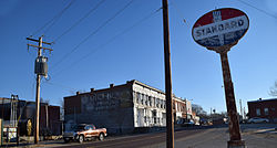
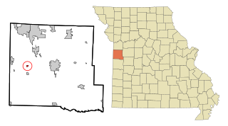
Urich is a city in Henry County, Missouri, United States. The population was 505 at the 2010 census.

<span class="mw-page-title-main">Carytown, Missouri</span> City in Missouri, United States

Carytown is a village in Jasper County, Missouri, United States. The population was 287 at the 2020 census. It is part of the Joplin, Missouri Metropolitan Statistical Area.

<span class="mw-page-title-main">Oronogo, Missouri</span> City in Missouri, United States

Oronogo is a city in Jasper County, Missouri, United States. The population was 2,558 at the 2020 census. It is part of the Joplin, Missouri Metropolitan Statistical Area.

<span class="mw-page-title-main">Tallapoosa, Missouri</span> City in Missouri, United States

Tallapoosa is a city in New Madrid County, Missouri, United States. The population was 78 at the 2020 census.

<span class="mw-page-title-main">Cooter, Missouri</span> City in Missouri, United States

Cooter is a city in Pemiscot County, Missouri, United States. The population was 343 at the 2020 census.

<span class="mw-page-title-main">Pleasant Hope, Missouri</span> City in Missouri, United States

Pleasant Hope is a city in Polk County, Missouri, United States. The population was 614 at the 2010 census. It is part of the Springfield, Missouri Metropolitan Statistical Area.

<span class="mw-page-title-main">Bella Villa, Missouri</span> City in Missouri, United States

Bella Villa is a city in St. Louis County, Missouri, in the United States. As of the 2010 census, the city population was 729.

<span class="mw-page-title-main">Beverly Hills, Missouri</span> City in Missouri, United States

Beverly Hills is a city in St. Louis County, Missouri, United States. As of the 2010 census, the city population was 574.

<span class="mw-page-title-main">Crystal Lake Park, Missouri</span> City in Missouri, United States

Crystal Lake Park is a Missouri Class 4 city in St. Louis County, Missouri, United States. The population was 508 at the 2020 census.

<span class="mw-page-title-main">Flordell Hills, Missouri</span> City in Missouri, United States

Flordell Hills is a city in St. Louis County, Missouri, United States. The population was 822 at the 2010 census.

<span class="mw-page-title-main">Northwoods, Missouri</span> City in Missouri, United States

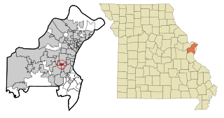
Northwoods is a city in St. Louis County, Missouri, United States. The population was 4,227 at the 2010 census.

<span class="mw-page-title-main">Pasadena Hills, Missouri</span> City in Missouri, United States

Pasadena Hills is a city in St. Louis County, Missouri, United States. The population was 930 at the 2010 census. The entire city is listed on the National Register of Historic Places.

<span class="mw-page-title-main">Velda City, Missouri</span> City in Missouri, United States

Velda City is a city in St. Louis County, Missouri, United States. The population was 1,420 at the 2010 census.

<span class="mw-page-title-main">Winchester, Missouri</span> City in Missouri, United States

Winchester is a city in St. Louis County, Missouri, United States. The population was 1,447 at the 2020 census.

<span class="mw-page-title-main">Schell City, Missouri</span> City in Missouri, United States

Schell City is a city in northeast Vernon County, Missouri, United States. The population was 249 at the 2010 census.

<span class="mw-page-title-main">Lake Annette, Missouri</span> City in Missouri, United States

Lake Annette is a city in Cass County, Missouri, United States. The population was 100 at the 2010 census. It is part of the Kansas City metropolitan area.

<span class="mw-page-title-main">Warson Woods, Missouri</span> City in Missouri, United States

Warson Woods is a city in St. Louis County, Missouri, United States. The population was 1,962 at the 2010 census.

References

  1. 1 2 3 U.S. Geological Survey Geographic Names Information System: Bunceton, Missouri
  2. "ArcGIS REST Services Directory". United States Census Bureau. Retrieved August 28, 2022.
  3. 1 2 "U.S. Census website". United States Census Bureau . Retrieved January 31, 2008.
  4. Earngey, Bill (1995). Missouri Roadsides: The Traveler's Companion. University of Missouri Press. p. 28. ISBN   9780826210210.
  5. Eaton, David Wolfe (1916). How Missouri Counties, Towns and Streams Were Named. The State Historical Society of Missouri. pp.  280.
  6. "Post Offices". Jim Forte Postal History. Archived from the original on March 6, 2016. Retrieved September 22, 2016.
  7. Werner, Alison. "On His Own Terms". Columbia Missourian. Retrieved February 13, 2020.
  8. Missouri Atlas & Gazetteer, DeLorme, 1998, First edition, p. 37, ISBN   0-89933-224-2
  9. "US Gazetteer files 2010". United States Census Bureau. Archived from the original on January 25, 2012. Retrieved July 8, 2012.
  10. "Census of Population and Housing". Census.gov. Retrieved June 4, 2015.
  11. "U.S. Census website". United States Census Bureau . Retrieved July 8, 2012.