Prairie Home, Missouri

Last updated
Prairie Home, Missouri
Cooper County Missouri Incorporated and Unincorporated areas Prairie Home Highlighted.svg
Location of Prairie Home, Missouri
Coordinates: 38°48′49″N92°35′26″W / 38.81361°N 92.59056°W / 38.81361; -92.59056 Coordinates: 38°48′49″N92°35′26″W / 38.81361°N 92.59056°W / 38.81361; -92.59056
Country United States
State Missouri
County Cooper
Area
[1]
  Total0.39 sq mi (1.00 km2)
  Land0.39 sq mi (1.00 km2)
  Water0.00 sq mi (0.00 km2)
Elevation
[2]
892 ft (272 m)
Population
 (2020)
  Total262
  Density675.26/sq mi (260.93/km2)
Time zone UTC-6 (Central (CST))
  Summer (DST) UTC-5 (CDT)
ZIP code
65068
Area code 660
FIPS code 29-59726 [3]
GNIS feature ID2396267 [2]

Prairie Home is a town, with legal status as a city, in Cooper County, Missouri, United States. The population was 280 at the 2010 census.

Contents

History

The town of Prairie Home was laid out in 1874 around the Prairie Home Institute, a school that had been built some time earlier. [4] Prairie Home is a descriptive name, referring to its scenic setting on the prairie. [5]

Geography

Prairie Home is located along Missouri Route 87 at its intersection with routes J and EE. The community is 1.5 miles west of the Cooper-Moniteau county line and approximately 13 miles southeast of Boonville. The Prairie Home Conservation Area is two miles south along Schaaf Creek. [6] [7]

According to the United States Census Bureau, the city has a total area of 0.39 square miles (1.01 km2), all land. [8]

Demographics

Historical population
CensusPop.Note
1880 43
1900 196
1910 184−6.1%
1920 1924.3%
1930 151−21.4%
1940 25166.2%
1950 208−17.1%
1960 2132.4%
1970 2318.5%
1980 27920.8%
1990 215−22.9%
2000 2202.3%
2010 28027.3%
2020 262−6.4%
U.S. Decennial Census [9]

2010 census

As of the census [10] of 2010, there were 280 people, 121 households, and 85 families living in the city. The population density was 717.9 inhabitants per square mile (277.2/km2). There were 132 housing units at an average density of 338.5 per square mile (130.7/km2). The racial makeup of the city was 98.9% White, 0.4% African American, 0.4% Asian, and 0.4% from two or more races. Hispanic or Latino of any race were 0.7% of the population.

There were 121 households, of which 31.4% had children under the age of 18 living with them, 55.4% were married couples living together, 10.7% had a female householder with no husband present, 4.1% had a male householder with no wife present, and 29.8% were non-families. 27.3% of all households were made up of individuals, and 18.2% had someone living alone who was 65 years of age or older. The average household size was 2.31 and the average family size was 2.78.

The median age in the city was 42.7 years. 22.1% of residents were under the age of 18; 5.4% were between the ages of 18 and 24; 27.4% were from 25 to 44; 19.7% were from 45 to 64; and 25.4% were 65 years of age or older. The gender makeup of the city was 48.9% male and 51.1% female.

2000 census

As of the census [3] of 2000,[ needs update ] there were 220 people, 104 households, and 61 families living in the city. The population density was 562.2 inhabitants per square mile (217.1/km2). There were 118 housing units at an average density of 301.6 per square mile (116.4/km2). The racial makeup of the city was 95.91% White, 0.45% Native American, and 3.64% from two or more races. Hispanic or Latino of any race were 1.36% of the population.

There were 104 households, out of which 25.0% had children under the age of 18 living with them, 48.1% were married couples living together, 8.7% had a female householder with no husband present, and 40.4% were non-families. 40.4% of all households were made up of individuals, and 25.0% had someone living alone who was 65 years of age or older. The average household size was 2.12 and the average family size was 2.82.

In the city the population was spread out, with 24.5% under the age of 18, 5.5% from 18 to 24, 23.2% from 25 to 44, 22.7% from 45 to 64, and 24.1% who were 65 years of age or older. The median age was 43 years. For every 100 females, there were 89.7 males. For every 100 females age 18 and over, there were 78.5 males.

The median income for a household in the city was $29,375, and the median income for a family was $37,250. Males had a median income of $31,250 versus $19,375 for females. The per capita income for the city was $15,182. About 3.4% of families and 6.0% of the population were below the poverty line, including 3.1% of those under the age of eighteen and 16.7% of those 65 or over.

Notable people

Related Research Articles

<span class="mw-page-title-main">Farnhamville, Iowa</span> City in Iowa, United States

Farnhamville is a city in Calhoun and Webster counties in the U.S. state of Iowa. The population was 383 at the time of the 2020 census.

<span class="mw-page-title-main">Prairie Village, Kansas</span> City in Kansas, United States

Prairie Village is a city in Johnson County, Kansas, United States, and located within the Kansas City Metropolitan Area. As of the 2020 census, the population of the city was 22,957.

<span class="mw-page-title-main">Prairie View, Kansas</span> City in Phillips County, Kansas

Prairie View is a city in Phillips County, Kansas, United States. As of the 2020 census, the population of the city was 106.

<span class="mw-page-title-main">Golden City, Missouri</span> City in Missouri, United States

Golden City is a city in Golden City Township, Barton County, Missouri, United States. The population was 656 at the 2020 census.

<span class="mw-page-title-main">Rich Hill, Missouri</span> City in Missouri, United States

Rich Hill is a city in southern Bates County, Missouri, and is part of the Kansas City metropolitan area within the United States. The population was 1,232 at the 2020 census.

<span class="mw-page-title-main">Auxvasse, Missouri</span> City in Missouri, United States

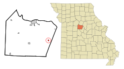
Auxvasse is a city in northern Callaway County, Missouri, United States. It is part of the Jefferson City, Missouri Metropolitan Statistical Area. The population was 983 at the 2010 census.

<span class="mw-page-title-main">Bosworth, Missouri</span> City in Missouri, United States

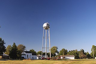
Bosworth is a city in Carroll County, Missouri, United States. The population was 213 at the 2020 U.S. Census.

<span class="mw-page-title-main">Buffalo, Missouri</span> City in Missouri, United States

Buffalo is a city in and the county seat of Dallas County, Missouri, United States. The population was 3,290 at the 2020 census.

<span class="mw-page-title-main">Laredo, Missouri</span> City in Missouri, United States

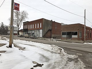
Laredo is a city in Grundy County, Missouri, United States. The population was 156 at the 2020 census. Laredo is pronounced "la-read-oh" which varies from the traditional pronunciation.

<span class="mw-page-title-main">Sarcoxie, Missouri</span> City in Missouri, United States

Sarcoxie is a city in Jasper County, Missouri, United States. The population was 1,406 at the 2020 census. It is part of the Joplin, Missouri Metropolitan Statistical Area.

<span class="mw-page-title-main">Knob Noster, Missouri</span> City in Missouri, United States

Knob Noster is a city in Johnson County, Missouri, United States. The population was 2,709 at the 2010 census. It is located adjacent to and closely associated with Whiteman Air Force Base. Knob Noster State Park is nearby.

<span class="mw-page-title-main">Anderson, Missouri</span> City in Missouri, United States

Anderson is a city in McDonald County, Missouri, United States. The population was 1,961 at the 2010 census.

<span class="mw-page-title-main">Anniston, Missouri</span> City in Missouri, United States

Anniston is a city in Mississippi County, Missouri, United States. The population was 180 at the 2020 census.

<span class="mw-page-title-main">Wyatt, Missouri</span> City in Missouri, United States

Wyatt is a city in Mississippi County, Missouri, United States. The population was 219 at the 2020 census. It is the easternmost city west of the Mississippi River.

<span class="mw-page-title-main">Hayti Heights, Missouri</span> City in Missouri, United States

Hayti Heights is a city in eastern Pemiscot County in the bootheel of southeast Missouri, United States. The population was 515 at the 2020 census.

<span class="mw-page-title-main">Homestown, Missouri</span> City in Missouri, United States

Homestown is a city in Pemiscot County, Missouri, United States. The population was 73 at the 2020 census.

<span class="mw-page-title-main">Hazelwood, Missouri</span> City in Missouri, United States

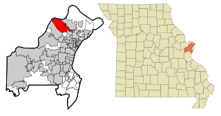
Hazelwood is a city in St. Louis County, Missouri, within Greater St. Louis. It is a second-ring northern suburb of St. Louis. Based on the 2020 United States census, the city had a total population of 25,485. It is located north of St. Louis-Lambert International Airport and is situated on Interstates 270 and 170, as well as the much-traveled Lindbergh Boulevard and Highway 370.

<span class="mw-page-title-main">Dudley, Missouri</span> City in Missouri, United States

Dudley is a city in Stoddard County, Missouri, United States. The population was 232 at the 2010 census.

<span class="mw-page-title-main">East Prairie, Missouri</span> City in Missouri, United States

East Prairie is a city in Mississippi County, Missouri, United States. The population was 2,943 at the 2020 census.

<span class="mw-page-title-main">Clarkson Valley, Missouri</span> City in Missouri, United States

Clarkson Valley is a city in St. Louis County, Missouri, United States. The population was 2,609 at the 2020 census.

References

  1. "ArcGIS REST Services Directory". United States Census Bureau. Retrieved August 28, 2022.
  2. 1 2 U.S. Geological Survey Geographic Names Information System: Prairie Home, Missouri
  3. 1 2 "U.S. Census website". United States Census Bureau . Retrieved 2008-01-31.
  4. Earngey, Bill (1995). Missouri Roadsides: The Traveler's Companion. University of Missouri Press. p. 24. ISBN   9780826210210.
  5. Eaton, David Wolfe (1916). How Missouri Counties, Towns and Streams Were Named. The State Historical Society of Missouri. pp.  281.
  6. Missouri Atlas & Gazetteer, DeLorme, 1st ed., 1998, p. 21, p.37, ISBN   0899332242
  7. Prairie Home, MO, 7.5 Minute Topographic Quadrangle, USGS, 1952 (1986 rev.)
  8. "US Gazetteer files 2010". United States Census Bureau. Archived from the original on 2012-01-25. Retrieved 2012-07-08.
  9. "Census of Population and Housing". Census.gov. Retrieved June 4, 2015.
  10. "U.S. Census website". United States Census Bureau . Retrieved 2012-07-08.