
Wabaunsee County is a county located in the U.S. state of Kansas. Its county seat is Alma. As of the 2020 census, the county population was 6,877. The county was named for Chief Waubonsie of the Potawatomi Indians.

Shawnee County is located in northeast Kansas, in the central United States. Its county seat and most populous city is Topeka, the state capital. As of the 2020 census, the population was 178,909, making it the third-most populous county in Kansas. The county was one of the original 33 counties created by the first territorial legislature in 1855, and it was named for the Shawnee tribe.

Morris County is a county located in the U.S. state of Kansas. Its county seat and largest city is Council Grove. As of the 2020 census, the county population was 5,386. The county was named for Thomas Morris, a U.S. Senator from Ohio and anti-slavery advocate.

Marion County is a county located in the U.S. state of Kansas. Its county seat is Marion and its most populous city is Hillsboro. As of the 2020 census, the county population was 11,823. The county was named in honor of Francis Marion, a brigadier general of the American Revolutionary War, known as the "Swamp Fox".

Cheyenne County is a county located in the northwest corner of the U.S. state of Kansas. Its county seat and most populous city is St. Francis. As of the 2020 census, the county population was 2,616. The county was named after the Cheyenne tribe.

Franklin is a city in Howard County, Missouri, United States. It is located along the Missouri River in the central part of the state. Located in a rural area, the city had a population of 70 at the 2020 census. It is part of the Columbia, Missouri Metropolitan Statistical Area.

Lexington is a city in, and the county seat of, Lafayette County, Missouri. The population was 4,726 at the 2010 census. Located in western Missouri, Lexington lies approximately 40 miles (64 km) east of Kansas City and is part of the Greater Kansas City Metropolitan Area. It is the home of the Battle of Lexington State Historic Site, and of the former Wentworth Military Academy and College, which operated from 1880 to 2017.
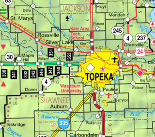
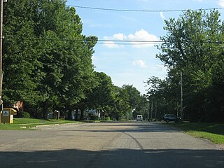
Dover is an unincorporated community in Shawnee County, Kansas, United States. It is located southwest of Topeka.
Tecumseh is an unincorporated community in Shawnee County, Kansas, United States, and situated along the Kansas River. As of the 2020 census, the population of the community and nearby areas was 696. The community and township are both named for the Shawnee chief.
The Lamine River is a 63.8-mile-long (102.7 km) tributary of the Missouri River in central Missouri in the United States. It is formed in northern Morgan County, about 4 miles (6 km) southeast of Otterville by the confluence of Flat and Richland creeks, and flows generally northwardly through Cooper and Pettis counties. In northwestern Cooper County the Lamine collects the Blackwater River and flows into the Missouri River northeast of Lamine and 6 miles (10 km) west of Boonville. At Clifton City, the river has a mean annual discharge of 455 cubic feet per second. Below the mouth of the Blackwater River, its discharge averages 1,279 cubic feet per second

Berryton is an unincorporated community in Shawnee County, Kansas, United States. It is located east of the Topeka Regional Airport.

Clear Creek Township is one of fourteen townships in Cooper County, Missouri, USA. As of the 2000 census, its population was 439.

Blackwater Township is one of fourteen townships in Cooper County, Missouri, USA. As of the 2000 census, its population was 406.

Lamine Township is one of 14 civil townships in Cooper County, in the U.S. state of Missouri. Twenty-two of Missouri's 114 counties, including Cooper County, have civil township governments. The other 92 counties have townships which are geographical but not governmental (civil). According to the 1860 Census, the population of Lamine Township was 830 . As of the 2020 Census, Lamine Township's population was 257.
Old Mines is the name of an unincorporated community and surrounding area in southeast Missouri that were settled by French colonists in the early 18th century when the area was part of the Illinois Country of New France. The early settlers came to mine for lead, and their descendants still inhabit the area where, through a combination of geographic and cultural isolation, they maintained a distinctive French culture well into the 20th century. As recently as the late 1980s there may have been a thousand native speakers of the region's Missouri French dialect. This culturally distinct population has sometimes been referred to as "paw-paw French" and lives in an amorphous area in Washington, Jefferson, and St. Francois counties roughly 15 miles (24 km) either side of a line from Potosi to De Soto. The community of Old Mines itself is in northeastern Washington County, six miles north of Potosi.
Grape Grove Township is an inactive township in Ray County, in the U.S. state of Missouri. It is part of the Kansas City metropolitan area.

Selma is an unincorporated community in Anderson County, Kansas, United States. It is located approximately four miles north-northeast of Kincaid next to a railroad.
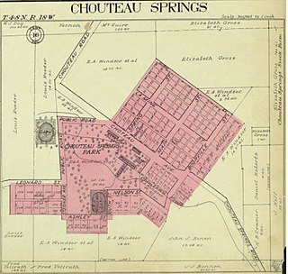
Chouteau Springs is an unincorporated community in Pilot Grove Township, Cooper County, in the U.S. state of Missouri.
Turley is an extinct town in Texas County, in the U.S. state of Missouri. The GNIS classifies it as a populated place. The community is located on Roubidoux Creek, approximately two miles downstream (northwest) of Roubidoux. The community of Plato is about 4.5 miles to the northwest.
The Turley Mill and Distillery Site is a historic site on the Rio Hondo about 11 miles (18 km) north of Taos, New Mexico. It was a mill and distillery which served as the headquarters of Simeon Turley's commercial and manufacturing empire. Simeon Turley (1809–1847) and his brothers Stephen Turley (1786–1851) and Jesse B. Turley (1801–1861) transported goods from Franklin, Missouri to Taos via wagon train on the Santa Fe Trail. About 1827–1829 Simeon settled in Arroyo Hondo and established the mill and distillery as a popular trading post and "watering hole." Simeon was murdered in the Taos Revolt of January 1847 and the mill and distillery site was all but destroyed. Simeon Turley is buried in the Kit Carson Memorial Cemetery in Taos. The mill and distillery site was listed on the State of New Mexico Register of Cultural Properties in 1969 and on the National Register of Historic Places in 1978.

