
Albany County is a county in the state of New York, United States. Its northern border is formed by the Mohawk River, at its confluence with the Hudson River, which is to the east. As of the 2020 United States Census, the population was 314,848. The county seat and largest city is Albany, which is also the state capital of New York. As originally established by the English government in the colonial era, Albany County had an indefinite amount of land, but has had an area of 530 square miles (1,400 km2) since March 3, 1888. The county is named for the Duke of York and of Albany, who became James II of England.

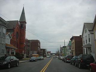
Watervliet is a city in northeastern Albany County, in the U.S. state of New York. The population was 10,375 as of the 2020 census. Watervliet is north of Albany, the capital of the state, and is bordered on the north, west, and south by the town of Colonie. The city is also known as "the Arsenal City".
Green Island is a coterminous town-village in Albany County, New York, United States, some 8 miles (13 km) north of Albany. Green Island is one of only five such town-village amalgamations in New York. The population was 2,620 at the 2010 census, and the ZIP code is 12183. While the town of Green Island was once an island, it was connected to the mainland on the west side of the Hudson River in the 1960s.

Colonie is a town in Albany County, New York, United States. It is the most-populous suburb of Albany, and is the third-largest town in area in Albany County, occupying approximately 11% of the county. Several hamlets exist within the town. As of the 2020 census, the town had a total population of 85,590.

Niskayuna is a town in Schenectady County, New York, United States. The population was 23,278 at the 2020 census. The town is located in the southeast part of the county, east of the city of Schenectady, and is the easternmost town in the county.

The New York Central Railroad was a railroad primarily operating in the Great Lakes and Mid-Atlantic regions of the United States. The railroad primarily connected greater New York and Boston in the east with Chicago and St. Louis in the Midwest, along with the intermediate cities of Albany, Buffalo, Cleveland, Cincinnati, Detroit, Rochester and Syracuse. New York Central was headquartered in New York City's New York Central Building, adjacent to its largest station, Grand Central Terminal.

The Capital District, also known as the Capital Region, is the metropolitan area surrounding Albany, the capital of the U.S. state of New York. The Capital District was first settled by the Dutch in the early 17th century and came under English control in 1664. Albany has been the permanent capital of the state of New York since 1797. The Capital District is notable for many historical events that predate the independence of the United States, including the Albany Plan of Union and the Battles of Saratoga.
The Troy & Schenectady Railroad was incorporated May 21, 1836. The stock was divided into five hundred shares at one hundred dollars each. The building of the road began in 1841, and trains began running from Schenectady to Troy, New York in the fall of 1841. It was constructed by the city of Troy, the corporation issuing its bonds in the amount of $649,142. Consolidated into the New York Central Railroad under the act of 1853.
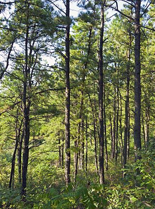
The Albany Pine Bush, referred to locally as the Pine Bush, is one of the largest of the 20 inland pine barrens in the world. It is centrally located in New York's Capital District within Albany and Schenectady counties, between the cities of Albany and Schenectady. The Albany Pine Bush was formed thousands of years ago, following the drainage of Glacial Lake Albany.
Latham is a hamlet and census-designated place in Albany County, New York, United States. It is located along U.S. Route 9 in the town of Colonie, a dense suburb north of Albany. As of the 2010 census, the population was 20,736. Latham was a census-designated place in the 1970, 1980, and 1990 US Censuses, but ceased to be in the 2000 Census, then became a CDP again in 2020.
Boght Corners is a hamlet in the town of Colonie in northern Albany County, New York, United States, that straddles U.S. Route 9. The corners that give the hamlet its name are found at the intersection of Route 9 and Boght Road, near the Boght Community Fire District's station. The community is served by the North Colonie Central School District. Boght Hills Elementary School is located within the hamlet.
Dunsbach Ferry is a hamlet of the town of Colonie, in Albany County, New York, United States. The hamlet sits to the east of, and below, the Thaddeus Kosciusko Bridge, where Interstate 87 (I-87) crosses the Mohawk River. There are numerous private and public docks and landings between the Twin Bridges and the Colonie Town Park. Dunsbach Ferry was once an important river crossing and a stop on the Schenectady and Troy Railroad (T&S), later a branch of the New York Central Railroad. The ZIP code is 12047 (Cohoes).
Verdoy, formerly known as Watervliet Center, is a hamlet of the town of Colonie in Albany County, New York, United States. Much of Verdoy is in the Airport Noise Overlay District due to its immediate proximity to Albany International Airport's main north/south runway, which was recently extended by 1,300 feet to the north, moving it even closer to Verdoy. The former Troy & Schenectady Branch of the New York Central Railroad runs along Verdoy's northern border with the Mohawk River; it is now part of the Mohawk Hudson Hike/Bike Trail.

New York State Route 787 (NY 787) is a state highway in Albany County, New York, in the United States. It is a northern extension of Interstate 787 (I-787), continuing northward from the underpass at exit 9 for NY 7 near Green Island to downtown Cohoes at NY 32. NY 787 is a four-lane divided boulevard named Cohoes Boulevard. For its entire length, NY 787 runs parallel to, and between, NY 32 and the Hudson River.

The Mohawk Towpath Scenic Byway is a National Scenic Byway in the Capital District region of New York in the United States. It extends from Schenectady to Waterford by way of a series of local, county, and state highways along the Mohawk River and the Erie Canal. The byway is intended to showcase the history of the waterway, from Native American times through the creation of the Erie Canal and the role the waterside communities played in the Industrial Revolution and the westward expansion of the United States. At its east end, the byway connects to the Lakes to Locks Passage, an All-American Road.
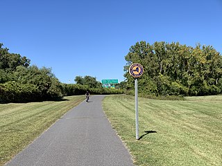
The Mohawk-Hudson Bike-Hike Trail (MHBHT) is a 97-mile (156 km) trail in New York's Mohawk Valley and Capital District regions. It is also the easternmost segment of the Erie Canalway Trail, as well as a portion of the Empire State Trail.
Watervliet was a town that at its height encompassed most of present-day Albany County and most of the current town of Niskayuna in neighboring Schenectady County, in the state of New York, United States. Just prior to its dissolution, the town encompassed the current towns of Colonie and Green Island and the city of Watervliet.
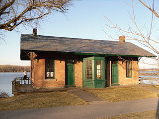
Niskayuna station is a historic railway station located at Niskayuna in Schenectady County, New York. It was possibly built in 1843 by the Schenectady and Troy Railroad and renovated or replaced in the 1880s. It is a one-story, rectangular, red brick masonry building on a foundation of rough cut quarry stone. It has a gable roof with broad eaves that cover the platform area. The rear wall of the station is situated directly upon the current, steep bank of the Mohawk River. It ceased to be used as a railroad facility in 1964, then was converted to a single family residence. It has been acquired by the town of Niskayuna as part of the Mohawk Hudson Hike/Bike Trail along the former railroad bed.

The Sprouts of the Mohawk River are the multiple channels of the Mohawk River as it flows into the Hudson River creating a delta in the US state of New York. Most of the sprouts lie within Albany County, with the northern ones in Saratoga County, and the sprouts enter the Hudson at the boundary with Rensselaer County. The islands formed by the sprouts are, from north to south–Peebles Island, Polrump Island, Bock Island, Goat Island, Second Island, Van Schaick Island, Simmons Island. and formerly Green Island. The sprout separating Green Island from the rest of Albany County was filled in with the creation of Interstate 787 and NY Route 787.

Aqueduct is a hamlet in the Town of Niskayuna, Schenectady County, New York, United States. Its center is at the south end of the bridge of New York State Route 146 over the Mohawk River, that connects Schenectady County to the south and Saratoga County to the north. It was formerly a transportation hub. Alexander's Bridge across the Mohawk antedated the Aqueduct. A new Route 146 steel highway bridge, with board pavement, parallel to the Aqueduct was built in the early 20th century. A Schenectady trolley line ended there, the line also serving Luna Park, just over the river in Rexford. There was, in Aqueduct, a staffed station of the Troy & Schenectady Railroad, which operated from 1841 to 1932.


