
Bethlehem is a town in Albany County, New York, United States. The town's population was 35,034 at the 2020 census. Bethlehem is located immediately to the south of the City of Albany. Bethlehem includes the following hamlets: Delmar, Elsmere, Glenmont, North Bethlehem, Selkirk, Slingerlands, and South Bethlehem. U.S. Route 9W passes through the town. The town is named after the biblical Bethlehem.

Guilderland is a town in Albany County, New York, United States. In the 2020 census, the town had a population of 36,848. The town is named for the Gelderland province in the Netherlands. The town of Guilderland is on the central-northwest border of the county. It is just west of Albany, the capital of the U.S. state of New York.

Westmere is a hamlet in the town of Guilderland, Albany County, New York, United States. Since the 1970 Census, a census-designated place (CDP) has been established with the name of Westmere for tabulating the population of what the census has defined as the boundaries for Westmere. The population was 7,284 at the 2010 census. It is a suburb of the neighboring city of Albany. U.S. Route 20 bisects the community and is the major thoroughfare and main street. Along Western Avenue are numerous strip malls, shopping plazas, and commercial buildings, with residential use on the side streets to the north and south. Crossgates Mall, the Capital District's largest shopping mall, is in Westmere's northeastern corner.
The West Shore Railroad was the final name of a railroad that ran from Weehawken, New Jersey, on the west bank of the Hudson River opposite New York City, north to Albany, New York, and then west to Buffalo. It was organized as a competitor to the New York Central and Hudson River Railroad, but was soon taken over by that company.
New York State Route 155 (NY 155) is a 16.85-mile-long (27.12 km) state highway located entirely within Albany County in the Capital District of New York. The western terminus of the route is at NY 85A in Voorheesville. The eastern terminus is at NY 32 in Watervliet. NY 155 mainly serves as a connection to the Albany International Airport from the major roads it connects to.
Guilderland Center is a hamlet in the town of Guilderland, Albany County, New York, United States. The hamlet lies along New York Route 146 and the Black Creek, a tributary of the Normans Kill.

New York State Route 85 (NY 85) is a state highway in Albany County, New York, in the United States. It is 26.49 miles (42.63 km) in length and runs from CR 353 in Rensselaerville to Interstate 90 (I-90) exit 4 in Albany. It also has a loop route, NY 85A, which connects NY 85 to the village of Voorheesville. The portion of NY 85 north of NY 140 to the Bethlehem–Albany town/city line is known as the Slingerlands Bypass. From there north to I-90, the road is a limited-access, four-lane highway named the Crosstown Arterial.

New York State Route 311 (NY 311) is a state highway located entirely within Putnam County, New York, in the United States. It begins at NY 52 in Lake Carmel, and intersects Interstate 84 (I-84) shortly thereafter. It crosses NY 164 and NY 292 as it heads into the northeastern part of the county, finally curving east to reach its northern terminus at NY 22 just south of the Dutchess County line. The route passes several historical sites.
Slingerlands is a hamlet in the town of Bethlehem, Albany County, New York, United States. It is located immediately west of Delmar and near the New Scotland town-line and south of the Albany city-limits, and is thus a suburb of Albany. The Slingerlands ZIP Code (12159) includes parts of the towns of New Scotland and Guilderland.
New York State Route 143 (NY 143) is a 18.82-mile-long (30.29 km) state highway in Albany County, New York, in the United States. The highway runs from an intersection with NY 85 in the town of Westerlo to a junction with NY 144 in the hamlet of Coeymans. The entire route is two lanes wide. NY 143 follows the path of the Coeymans and Westerlo Plank Road, a plank road that operated from 1850 to the early 20th century. The road became a state highway by 1915 and was designated NY 143 as part of the 1930 renumbering of state highways in New York.

New York State Route 397 (NY 397) is a short state highway in New York, running from the village of Altamont to the hamlet of Dunnsville within the town of Guilderland, in Albany County. NY 397 is a two-lane highway its entire length.
Feura Bush is a hamlet in the town of New Scotland, Albany County, New York, United States. It is in the southeastern corner of the town, along the Bethlehem town-line, eight miles south of Albany. The Feura Bush ZIP Code (12067) includes parts of the town of Bethlehem. It is in the Onesquethaw Volunteer Fire Company fire protection district. The 2020 Census showed 28 employer establishments in the hamlet.

Alcove is a hamlet in the town of Coeymans, Albany County, New York, United States. It is a prime example of a 19th-century mill town located at a rural intersection, and as such it is listed on the National Register of Historic Places in the Albany area as the Alcove Historic District. The city of Albany's Alcove Reservoir lies to the west of the hamlet.
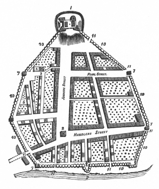
The streets of Albany, New York have had a long history going back almost 400 years. Many of the streets have changed names over the course of time, some have changed names many times. Some streets no longer exist, others have changed course. Some roads existed only on paper. The oldest streets were haphazardly laid out with no overall plan until Simeon De Witt's 1794 street grid plan. The plan had two grids, one west of Eagle Street and the old stockade, and another for the Pastures District south of the old stockade.
McKownville is a hamlet in the town of Guilderland, Albany County, New York, United States. It lies along the eastern border of the town with the city of Albany. McKownville is a heavily developed suburb of Albany and is home to many strip malls, shopping centers, and a portion of the University at Albany, SUNY and is bisected by U.S. Route 20. McKownville is named for John McKown and family, early settlers from the late 18th century.
Guilderland is a hamlet of the town of the same name in Albany County, New York, United States.
Fort Hunter is a hamlet in the town of Guilderland, Albany County, New York, United States. Fort Hunter lies along New York Route 146 near the Albany-Schenectady county line. Exit 25 of the Governor Thomas E. Dewey Thruway and exit 9B of Interstate 890 is at the northern limits of the hamlet.
Kenwood was a hamlet in the Town of Bethlehem, New York. The hamlet spanned both sides of the Normans Kill near the area where the Normans Kill flows into the Hudson River. In 1870, and again in 1910, northern portions of Kenwood were annexed by the City of Albany, New York.
South Bethlehem is a hamlet in the town of Bethlehem, Albany County, New York, United States. The hamlet sits on New York State Route 396 and lies southwest of the Selkirk Rail Yard and just north of the Coeymans town line.
Clarksville is a hamlet in the town of New Scotland, Albany County, New York, United States. It is situated along Delaware Turnpike in the southern part of the town at the foot of the Helderberg Escarpment. It is the site of the Clarksville Cave and has an annual Clarksville Heritage Day and Car Show. It is in the Onesquethaw Volunteer Fire Company fire protection district.


