
Albany County is a county in the state of New York, United States. Its northern border is formed by the Mohawk River, at its confluence with the Hudson River, which is to the east. As of the 2020 United States Census, the population was 314,848. and largest city is Albany, the state capital of New York. As originally established by the English government in the colonial era, Albany County had an indefinite amount of land, but has had an area of 530 square miles (1,400 km2) since March 3, 1888. The county is named for the Duke of York and of Albany, who became James II of England.
Interstate 90 (I-90) is an east–west transcontinental freeway and the longest Interstate Highway in the United States at 3,020.44 miles (4,860.93 km). Its western terminus is in Seattle, Washington, at State Route 519 near T-Mobile Park and Lumen Field, and its eastern terminus is in Boston, Massachusetts, at Route 1A near Logan International Airport.
Interstate 87 (I-87) is a 333.49-mile-long (536.70 km) north–south intrastate Interstate Highway located within the U.S. state of New York, and is most of the main highway between New York City and Montreal. The highway begins at exit 47 off I-278 in the New York City borough of the Bronx, just north of the Triborough Bridge and Grand Central Parkway. From there, the route runs northward through the Hudson Valley, the Capital District, and the easternmost part of the North Country to the Canadian border in the Town of Champlain. At its north end, I-87 continues into Quebec as Autoroute 15 (A-15). I-87 connects with several regionally important roads: I-95 in New York City, New York State Route 17 near Harriman, I-84 near Newburgh, and I-90 in Albany. The route is the longest intrastate Interstate Highway in the Interstate Highway System. The highway is not contiguous with I-87 in North Carolina.

Florida is a town south of the Mohawk River in Montgomery County, New York, United States. The population was 2,696 in the 2010 United States Census. The town was named after the state of Florida. It is located in the eastern end of Montgomery County and is south of the City of Amsterdam, which it borders.
Interstate 890 (I-890) is a 9.45-mile-long (15.21 km) auxiliary Interstate Highway in the vicinity of Schenectady, New York, in the United States. The highway runs southeast–northwest from an interchange with the New York State Thruway (I-90) northwest of Schenectady to another junction with the Thruway south of the city and passes through Downtown Schenectady along the way. Most of I-890 is six lanes wide, including a section that runs above an industrial section of Schenectady on an elevated highway. I-890 is a local, toll-free alternative to the Thruway, which bypasses the city and its suburbs to the southwest.
The New York State Thruway is a system of controlled-access highways spanning 569.83 miles (917.05 km) within the U.S. state of New York. It is operated by the New York State Thruway Authority (NYSTA), a New York State public-benefit corporation. The 496.00-mile (798.23 km) mainline is a toll road that extends from the New York City line at Yonkers to the Pennsylvania state line at Ripley by way of I-87 and I-90 through Albany, Syracuse, and Buffalo. According to the International Bridge, Tunnel and Turnpike Association, the Thruway is the fifth-busiest toll road in the United States.
New York State Route 5 (NY 5) is a state highway that extends for 370.80 miles (596.74 km) across the state of New York in the United States. It begins at the Pennsylvania state line in the Chautauqua County town of Ripley and passes through Buffalo, Syracuse, Utica, Schenectady, and several other smaller cities and communities on its way to downtown Albany in Albany County, where it terminates at U.S. Route 9 (US 9), here routed along the service roads for Interstate 787 (I-787). Prior to the construction of the New York State Thruway, it was one of two main east–west highways traversing upstate New York, the other being US 20. West of New York, NY 5 continues as Pennsylvania Route 5 (PA 5) to Erie.
New York State Route 32 (NY 32) is a north–south state highway that extends for 176.73 miles (284.42 km) through the Hudson Valley and Capital District regions of the U.S. state of New York. It is a two-lane surface road for nearly its entire length, with few divided and no limited-access sections. From Harriman to Albany, it is closely parallel to Interstate 87 (I-87) and U.S. Route 9W (US 9W), overlapping with the latter in several places.
Interstate 88 (I-88) is an Interstate Highway located entirely within the U.S. state of New York. Nominally an east–west road as it has an even number, it extends for 117.70 miles (189.42 km) in a northeast–southwest direction from an interchange with I-81 north of Binghamton to an interchange with the New York State Thruway (I-90) west of Schenectady. The freeway serves as an important connector route from the Capital District to Binghamton, Elmira, and Scranton, Pennsylvania. I-88 closely parallels NY 7, which was once the main route through the area.

The Albany Pine Bush, referred to locally as the Pine Bush, is one of the largest of the 20 inland pine barrens in the world. It is centrally located in New York's Capital District within Albany and Schenectady counties, between the cities of Albany and Schenectady. The Albany Pine Bush was formed thousands of years ago, following the drainage of Glacial Lake Albany.
New York State Route 7 (NY 7) is a 180.30-mile-long (290.16 km) state highway in New York in the United States. The highway runs from Pennsylvania Route 29 (PA 29) at the Pennsylvania state line south of Binghamton to Vermont Route 9 (VT 9) the Vermont state line east of Hoosick. Most of the road runs along the Susquehanna Valley, closely paralleling Interstate 88 (I-88) throughout that road's length. Portions of the highway route near the cities of Binghamton, Schenectady, and Troy date back to the early 19th century.
New York State Route 146 (NY 146) is a state highway in the Capital District of New York in the United States. It extends for 43 miles (69 km) from Gallupville at NY 443 to near Mechanicville at U.S. Route 4 (US 4) and NY 32. NY 146 is a major thoroughfare in the city of Schenectady, just outside Albany. Most of the route follows an east–west alignment; however, the middle third of the route between Guilderland and Clifton Park runs in a more north–south manner in order to serve Schenectady. At one time, NY 146 had three spur routes; only one—NY 146A—still exists.
New York State Route 5S (NY 5S) is a 72.92-mile-long (117.35 km) east–west state highway located in the Mohawk Valley of New York in the United States. It extends from a continuation of NY 5A at an interchange with NY 5, NY 8, NY 12, and Interstate 790 (I-790) in Utica to an interchange with NY 890 in Rotterdam. The route runs along the south side of the Mohawk River for its entire length and parallels NY 5, which runs along the north side of the Mohawk River. NY 5S intersects several primary routes including NY 28 in Mohawk, NY 30A in Fultonville, NY 30 south of Amsterdam, as well as intersecting the New York State Thruway (I-90) several times. The route is part of New York State Bicycle Route 5 west of its junction with NY 103 in Schenectady County.
New York State Route 10 (NY 10) is a north–south state highway in the Central New York and North Country regions of New York in the United States. It extends for 155 miles (249 km) from the Quickway (NY 17) in Deposit, Delaware County to NY 8 at Higgins Bay, a hamlet in the Hamilton County town of Arietta. NY 10 begins concurrent with NY 8. While NY 8 follows a more westerly alignment between Deposit and Higgins Bay via Utica, NY 10 veers to the east, serving Delhi, Cobleskill, and Canajoharie. Along the way, the road intersects Interstate 88 (I-88) near Cobleskill and U.S. Route 20 (US 20) in Sharon Springs.
New York State Route 158 (NY 158) is a state highway in New York, running from near the Albany County village of Altamont to the Schenectady County town of Rotterdam, just outside Schenectady. NY 158 is a two-lane highway for all of its length.
New York State Route 144 (NY 144) is a state highway in the Capital District of New York in the United States. The highway runs for 14.74 miles (23.72 km) as a two-lane road from an intersection with U.S. Route 9W (US 9W) in the Greene County town of New Baltimore to a junction with NY 32 in the town of Bethlehem just south of the Albany city limits. NY 144 closely parallels the New York State Thruway and the west bank of the Hudson River as it heads across Albany County. The Thruway and NY 144 connect at exit 22 about 6 miles (9.7 km) south of Albany in Bethlehem.
Interstate 90 (I-90) is a part of the Interstate Highway System that runs from Seattle, Washington, to Boston, Massachusetts. In the U.S. state of New York, I-90 extends 385.88 miles (621.01 km) from the Pennsylvania state line at Ripley to the Massachusetts state line at Canaan, and is the second-longest highway in the state after NY 17. Although most of the route is part of the tolled New York State Thruway, two non-tolled sections exist along I-90. Within New York, I-90 has a complete set of auxiliary Interstates, which means that there are interstates numbered I-190 through I-990 in the state, with no gaps in between. For most of its length in New York, I-90 runs parallel to the former Erie Canal route, New York State Route 5 (NY 5), U.S. Route 20 (US 20) and the CSX railroad mainline that traverses the state.
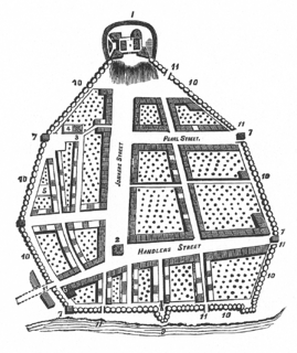
The streets of Albany, New York have had a long history going back almost 400 years. Many of the streets have changed names over the course of time, some have changed names many times. Some streets no longer exist, others have changed course. Some roads existed only on paper. The oldest streets were haphazardly laid out with no overall plan until Simeon De Witt's 1794 street grid plan. The plan had two grids, one west of Eagle Street and the old stockade, and another for the Pastures District south of the old stockade.

Karner is a hamlet of the town of Colonie, Albany County, New York, United States. Once called Center Station, it was a stop along the New York Central Railroad (NYCRR) that became famous for being the site where the Karner Blue butterfly was first identified.
McKownville is a hamlet in the town of Guilderland, Albany County, New York, United States. It lies along the eastern border of the town with the city of Albany. McKownville is a heavily developed suburb of Albany and is home to many strip malls, shopping centers, and a portion of the University at Albany, SUNY and is bisected by U.S. Route 20. McKownville is named for John McKown and family, early settlers from the late 18th century.


