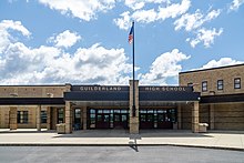
Guilderland is a town in Albany County, New York, United States. In the 2020 census, the town had a population of 36,848. The town is named for the Gelderland province in the Netherlands. The town of Guilderland is on the central-northwest border of the county. It is just west of Albany, the capital of the U.S. state of New York.

Rensselaerville is a town in Albany County, New York, United States. The population was 1,826 at the 2020 census. The town is named after Stephen Van Rensselaer.

Watervliet is a city in northeastern Albany County, in the U.S. state of New York. The population was 10,375 as of the 2020 census. Watervliet is north of Albany, the capital of the state, and is bordered on the north, west, and south by the town of Colonie. The city is also known as "the Arsenal City".
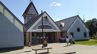
Clifton Park is a suburban town in Saratoga County, New York, United States. According to the United States Census Bureau, the 2020 population was 38,029. The name is derived from an early land patent. The town is in the southern part of Saratoga County, approximately 12 miles (19 km) north of Albany, 7 miles (11 km) northeast of Schenectady, and 10 miles (16 km) south of Saratoga Springs.

Colonie is a town in Albany County, New York, United States. It is the most-populous suburb of Albany, and is the third-largest town in area in Albany County, occupying approximately 11% of the county. Several hamlets exist within the town. As of the 2020 census, the town had a total population of 85,590.

East Greenbush is a town in Rensselaer County, New York, United States. It is a suburb of Albany. The population was 16,473 at the 2010 census. The word Greenbush is derived from the Dutch het groen bosch, referring to the pine woods that originally covered the land. The first settlement of the land now known as East Greenbush was made by tenants under patroon Kiliaen van Rensselaer circa 1630. The town was established in 1855 as Clinton, and was renamed in 1858. It is mostly suburban along its major highways and rural in the southwestern and northeastern corners.

Loudonville is a hamlet in the town of Colonie, in Albany County, New York, United States. Loudonville was a census-designated place in the 1970, 1980, and 1990 US Census, but ceased to be in the 2000 Census, but became a CDP again in 2020.
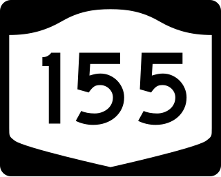
New York State Route 155 (NY 155) is a 16.85-mile-long (27.12 km) state highway located entirely within Albany County in the Capital District of New York. The western terminus of the route is at NY 85A in Voorheesville. The eastern terminus is at NY 32 in Watervliet. NY 155 mainly serves as a connection to the Albany International Airport from the major roads it connects to.
Slingerlands is a hamlet in the town of Bethlehem, Albany County, New York, United States. It is located immediately west of Delmar and near the New Scotland town-line and south of the Albany city-limits, and is thus a suburb of Albany. The Slingerlands ZIP Code (12159) includes parts of the towns of New Scotland and Guilderland.

New York State Route 158 (NY 158) is a state highway in New York, running from near the Albany County village of Altamont to the Schenectady County town of Rotterdam, just outside Schenectady. NY 158 is a two-lane highway for all of its length.

New York State Route 156 (NY 156) is a state highway in Albany County, New York. NY 156 begins at a junction with NY 443 in the town of Berne. Serving the hamlet of Knox and the village of Altamont, NY 156 soon reaches the town of Voorheesville and ends at a junction with NY 85A.

New York State Route 397 (NY 397) is a short state highway in New York, running from the village of Altamont to the hamlet of Dunnsville within the town of Guilderland, in Albany County. NY 397 is a two-lane highway its entire length.

The neighborhoods of Albany, New York are listed below.
Benjamin Knower was an American merchant, banker and politician.
Newtonville is a hamlet in the town of Colonie in Albany County, New York, United States. Located along U.S. Route 9, the hamlet is just south of Latham and north of Loudonville. Colonie Town Hall is located in the hamlet of Newtonville.

Alcove is a hamlet in the town of Coeymans, Albany County, New York, United States. It is a prime example of a 19th-century mill town located at a rural intersection, and as such it is listed on the National Register of Historic Places in the Albany area as the Alcove Historic District. The city of Albany's Alcove Reservoir lies to the west of the hamlet.
Lisha Kill is a hamlet in the town of Colonie, Albany County, New York, United States. Lisha Kill lies on New York Route 5 in the western section of the town. The hamlet received its name from the creek of the same name, Lisha Kill, kill being Dutch for creek or stream. The stream is also referred to as Lisha's Kill and received its name from a local legend about a Native American woman who is buried along its banks.
Guilderland is a hamlet of the town of the same name in Albany County, New York, United States.
Kenwood was a hamlet in the Town of Bethlehem, New York. The hamlet spanned both sides of the Normans Kill near the area where the Normans Kill flows into the Hudson River. In 1870, and again in 1910, northern portions of Kenwood were annexed by the City of Albany, New York.

The Normans Kill is a 45.4-mile-long (73.1 km) creek in New York's Capital District located in Schenectady and Albany counties. It flows southeasterly from its source in the town of Duanesburg near Delanson to its mouth at the Hudson River in the town of Bethlehem. In the town of Guilderland, the stream is dammed to create the Watervliet Reservoir, a drinking water source for the city of Watervliet and the Town of Guilderland. A one megawatt hydrolectric plant at the dam provides power to pump water to the filtration plant.