
Delmar is a hamlet in the Town of Bethlehem, in Albany County, New York, United States. It is a suburb of the neighboring city of Albany. The community is bisected by NY Route 443, a major thoroughfare, main street, and route to Albany.

Watervliet is a city in Albany County in the U.S. state of New York. The population was 10,254 as of the 2010 census. Watervliet is north of Albany, the capital of the state, and is bordered on the north, west, and south by the town of Colonie. The city is also known as "the Arsenal City".

Loudonville is a hamlet in the town of Colonie, in Albany County, New York, United States. Loudonville was a census-designated place in the 1970, 1980, and 1990 US Census, but ceased to be in the 2000 Census, but became a CDP again in 2020.
Boght Corners is a hamlet in the town of Colonie in northern Albany County, New York that straddles U.S. Route 9. The corners that give the hamlet its name are found at the intersection of Route 9 and Boght Road, near the Boght Community Fire District's station. The community is served by the North Colonie Central School District. Boght Hills Elementary School is located within the hamlet.
Verdoy, formerly known as Watervliet Center, is a hamlet of the town of Colonie in Albany County, New York, United States. Much of Verdoy is in the Airport Noise Overlay District due to its immediate proximity to Albany International Airport's main north/south runway, which was recently extended by 1,300 feet to the north, moving it even closer to Verdoy. The former Troy & Schenectady Branch of the New York Central Railroad runs along Verdoy's northern border with the Mohawk River; it is now part of the Mohawk Hudson Hike/Bike Trail.
Guilderland Center is a hamlet in the town of Guilderland, Albany County, New York, United States. The hamlet lies along New York Route 146 and the Black Creek, a tributary of the Normans Kill.
Slingerlands is a hamlet in the town of Bethlehem, Albany County, New York, United States. It is located immediately west of Delmar and near the New Scotland town-line and south of the Albany city-limits, and is thus a suburb of Albany. The Slingerlands ZIP Code (12159) includes parts of the towns of New Scotland and Guilderland.
Feura Bush is a hamlet in the town of New Scotland, Albany County, New York, United States. It is in the southeastern corner of the town, along the Bethlehem town-line, eight miles south of Albany. The Feura Bush ZIP Code (12067) includes parts of the town of Bethlehem. It is in the Onesquethaw Volunteer Fire Company fire protection district.
Newtonville is a hamlet in the town of Colonie in Albany County, New York, United States. Located along U.S. Route 9, the hamlet is just south of Latham and north of Loudonville. Colonie Town Hall is located in the hamlet of Newtonville.
The town of Watervliet was a town that at its height encompassed most of present-day Albany County and most of the current town of Niskayuna in neighboring Schenectady County, in the state of New York, United States. Just prior to its dissolution, the town encompassed the current towns of Colonie and Green Island and the city of Watervliet.
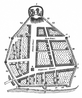
The streets of Albany, New York have had a long history going back almost 400 years. Many of the streets have changed names over the course of time, some have changed names many times. Some streets no longer exist, others have changed course. Some roads existed only on paper. The oldest streets were haphazardly laid out with no overall plan until Simeon De Witt's 1794 street grid plan. The plan had two grids, one west of Eagle Street and the old stockade, and another for the Pastures District south of the old stockade.
Beeren Island, also known as Barren Island or Bear Island, is an island in the Hudson River within the town of Coeymans, New York. It lies 11 miles (18 km) south of the city of Albany, and is at the border of four counties, Albany, Greene, Columbia, and Rensselaer. Beeren Island was once referred to as Mach-a-wa-meck, which may come from mashq (bear) and wamock (enough), meaning "place of many bears" and would make it in agreement with the Dutch name.
West Albany is a hamlet in the town of Colonie, Albany County, New York, United States. Parts of the neighboring city of Albany around Watervliet Avenue Extension and Industrial Park Road are also considered part of West Albany and includes the majority of the West Albany Rail Yard. The hamlet lies along Albany's northern border and was once home to many industries, including one of the largest cattle stockyards in the United States, a large railroad switching yard, and a Tobin First Prize packing plant. Those industries are gone now and the community is mostly a residential suburb of Albany in the shadow of abandoned industrial complexes. West Albany has historically been ethnically diverse with Polish, Italian, Irish, German, and English immigrants drawn by the 5,000+ jobs at the West Albany Rail Yard. Though the neighborhood is predominately Italian-American, it remains diverse with the Polish American Citizens Club, the West Albany Italian Benevolent Society, the Bet Shraga Hebrew Academy, and a Korean worship center in the former St. Francis de Sales Catholic Church.
Roessleville is a hamlet in the town of Colonie, Albany County, New York. It is a densely settled suburb of the city of Albany along New York State Route 5. Roessleville was a census-designated place in the 1990 Census, but was deleted in 2000, but became a CDP again in 2020.
Guilderland is a hamlet of the town of the same name in Albany County, New York, United States.
Fullers is a hamlet in the town of Guilderland, Albany County, New York, United States. The hamlet lies along U.S. Route 20.
Normansville is a former hamlet in Albany County, New York, United States. In the 19th century, Normansville was a hamlet in the town of Bethlehem. Normansville was located within and along the north and south banks of the ravine carved by the Normans Kill Creek, a tributary of the Hudson River.
Kenwood was a hamlet in the Town of Bethlehem, New York. The hamlet spanned both sides of the Normans Kill near the area where the Normans Kill flows into the Hudson River. In 1870, and again in 1910, northern portions of Kenwood were annexed by the City of Albany, New York.
South Bethlehem is a hamlet in the town of Bethlehem, Albany County, New York, United States. The hamlet sits on New York State Route 396 and lies southwest of the Selkirk Rail Yard and just north of the Coeymans town line.

The history of Albany, New York prior to 1664 begins with the native inhabitants of the area and ends in 1664, with the English takeover of New Netherland. The area was originally inhabited by Algonquian Indian tribes and was given different names by the various peoples. The Mohican called it Pempotowwuthut-Muhhcanneuw, meaning "the fireplace of the Mohican nation", while the Iroquois called it Sche-negh-ta-da, or "through the pine woods". Albany's first European structure was a primitive fort on Castle Island built by French traders in 1540. It was destroyed by flooding soon after construction.


