Slingerlands, New York

Last updated
Slingerlands
Etymology: For William Slingerland and descendants
USA New York location map.svg
Red pog.svg
Slingerlands
Location of Slingerlands within the state of New York
Coordinates: 42°37′45″N73°51′52″W / 42.62917°N 73.86444°W / 42.62917; -73.86444 Coordinates: 42°37′45″N73°51′52″W / 42.62917°N 73.86444°W / 42.62917; -73.86444
Country United States
State New York
Region Capital District
County Albany
Settled1850
Elevation
220 ft (70 m)
Time zone UTC-5 (EST)
  Summer (DST) UTC-4 (EDT)
ZIP Code
12159
Area code(s) 518

Slingerlands is a hamlet in the town of Bethlehem, Albany County, New York, United States. It is located immediately west of Delmar and near the New Scotland town-line and south of the Albany city-limits, and is thus a suburb of Albany. The Slingerlands ZIP Code (12159) includes parts of the towns of New Scotland and Guilderland.

Contents

History

View of the tollgate in Slingerlands, this was demolished in 1908. SlingerlandsTollgate.jpg
View of the tollgate in Slingerlands, this was demolished in 1908.

The history of Slingerlands begins in 1850 when the Albany, Rensselaerville, and Schoharie Plank Road Company was established by the state to construct a plank road from Albany, through Slingerlands, to Gallupville in Schoharie County. [1] In 1854, the state authorized the company to abandon or sell portions and to turn other sections (including that part in Slingerlands) into a turnpike and charge tolls. [2] The post office was originally called Normanskill and was built in 1852 with William H. Slingerland as the first post master. [3] In 1863, the Albany and Susquehanna Railroad was built through Slingerlands with a station established here as well. [4] William H. Slingerland was the surveyor of the road, and since his route came in $600,000 less than a previous survey the company named the station here Slingerlands in his honor. [5] In 1870, the post office also took the name Slingerlands. [3] After having been in the rear of a grocery store for a hundred years it moved to the Tollgate Building in 1953, until the 1990s when a newer larger location was built near the Price Chopper Plaza. [6] [7] In 1989, the New Scotland post office was closed and the 400 residents it served were transferred to Slingerlands' ZIP Code. [7]

Aerial view of Slingerlands Bypass (to the left) and New Scotland Road (to the right). Slingerlands bypass.JPG
Aerial view of Slingerlands Bypass (to the left) and New Scotland Road (to the right).

New Scotland Road through Slingerlands was labeled as part of New York State Route 85 in the 1930 renumbering of state highways. [8] In 1968, the Slingerlands Bypass was constructed as a two-lane extension of the Crosstown Connection, a limited-access highway in the city of Albany; Route 85 was then routed onto this highway. [9] The original plan was to connect with the Delmar Bypass near New York State Route 85A, thereby bypassing Slingerlands, it and the Delmar Bypass were never finished due to a lack of funding. [10] [11] In 1987, the developer of the Juniper Fields sub-division agreed to build for the town a 1,700 foot extension of the Delmar Bypass to Van Dyke Avenue, and the developer of Delmar Village agreed to build a 2,750 foot extension of Fisher Boulevard to Delaware Avenue, this then left only a 6,000 foot extension of the Delmar Bypass to complete a full loop around Delmar and Slingerlands. At the time it was still the long-term goal of the town to extend both bypasses themselves to their original meeting point near Route 85A. [10] In 2007, the existing Slingerlands Bypass was reconstructed from two to four lanes and the highway was extended behind the Price Chopper Plaza to meet New Scotland Road over Le Grange Road opposite Cherry Avenue Extension. Each intersection, four in all, were converted to two-lane roundabouts. [12]

The Slingerlands Homeowners Association was founded in 1972 and is the oldest neighborhood association in the town of Bethlehem. [13] The neighborhood group had become moribund by the late 1980s, but was reactivated by controversy over a new shopping center and succeeded in having the shopping center, today the Price Chopper Plaza, scaled back by almost half. [14]

In 1987, Slingerlands was the site of filming for some scenes in the movie Ironweed, which starred Jack Nicholson, based on the book of the same name written by William Kennedy. Scenes were filmed of a recreated 1930s era steam locomotive and the Dillenbeck House at 1511 New Scotland Road (built in 1876). [15] [16]

The Slingerlands Historic District was listed on the National Register of Historic Places in 2012. [17] Also listed are the House at 698 Kenwood Avenue, LeGrange Farmstead, and Albert Slingerlands House. [18]

Geography

Slingerlands is situated along New Scotland Road (New York State Route 85) from the Albany city-limits south and west to Fisher Boulevard near the New Scotland town-line; and along Kenwood Avenue east from NY 85 to Adrianca Lane. [19]

Location

Demographics

The population of Slingerlands ZIP code, which is larger geographically than the hamlet itself is 7,646. [20]

Architecture

Slingerlands is predominately residential, with commercial properties mostly along New Scotland Road from the Albany city-line south to the intersection with Kenwood Avenue. Many historic homes and buildings from the 1800s still stand in the heart of the hamlet, many of which are associated with the founding family of the Slingerland's, such as the Dillenback House built by Albert Slingerland. The oldest house in the hamlet is that of John Albert Slingerland, [19] and Albert I. Slingerland built the Slingerlands Community Methodist Church in 1872. The Old Slingerlands Schoolhouse built in 1908 has been converted into apartments. [16]

Much of the newer residential construction has been built in a style to imitate that of the historic house-styles, such as Greek Revival, Federal, Victorian, and Colonial. [19] A house in Slingerlands built in 1922 was once the official residence for the president of the University at Albany, SUNY. [16] Among the relatively new, yet still historic, is a 1929 cottage built from a kit bought from the Sears, Roebuck catalogue. [21]

Education

Slingerlands is a part of the Bethlehem Central School District (BCS) and the children attend Slingerlands Elementary School for kindergarten through fifth grade; and Bethlehem Central Middle School and Bethlehem Central High School for sixth through twelfth. [19]

Related Research Articles

Bethlehem, New York Town in New York, United States

Bethlehem is a town in Albany County, New York, United States. The town's population was 33,656 at the 2010 census. Bethlehem is located immediately to the south of the City of Albany. Bethlehem includes the following hamlets: Delmar, Elsmere, Glenmont, North Bethlehem, Selkirk, Slingerlands, and South Bethlehem. U.S. Route 9W passes through the town. The town is named after the biblical Bethlehem.

Delmar, New York Hamlet in New York, United States

Delmar is a hamlet in the Town of Bethlehem, in Albany County, New York, United States. It is a suburb of the neighboring city of Albany. The community is bisected by NY Route 443, a major thoroughfare, main street, and route to Albany.

New York State Route 32 (NY 32) is a north–south state highway that extends for 176.73 miles (284.42 km) through the Hudson Valley and Capital District regions of the U.S. state of New York. It is a two-lane surface road for nearly its entire length, with few divided and no limited-access sections. From Harriman to Albany, it is closely parallel to Interstate 87 (I-87) and U.S. Route 9W (US 9W), overlapping with the latter in several places.

New York State Route 335 (NY 335) is a north–south state highway located within the town of Bethlehem in Albany County, New York, in the United States. It extends for 1.77 miles (2.85 km) from an intersection with Feura Bush Road near the hamlet of Delmar to a junction with NY 443 in the hamlet of Elsmere. The two-lane route, named Elsmere Avenue, also has an intersection with NY 32 about halfway through the route. NY 335 was assigned to its current alignment in the 1930s.

Boght Corners, New York Hamlet in New York, United States

Boght Corners is a hamlet in the town of Colonie in northern Albany County, New York, United States, that straddles U.S. Route 9. The corners that give the hamlet its name are found at the intersection of Route 9 and Boght Road, near the Boght Community Fire District's station. The community is served by the North Colonie Central School District. Boght Hills Elementary School is located within the hamlet.

New York State Route 85 (NY 85) is a state highway in Albany County, New York, in the United States. It is 26.49 miles (42.63 km) in length and runs from CR 353 in Rensselaerville to Interstate 90 (I-90) exit 4 in Albany. It also has a loop route, NY 85A, which connects NY 85 to the village of Voorheesville. The portion of NY 85 north of NY 140 to the Bethlehem–Albany town/city line is known as the Slingerlands Bypass. From there north to I-90, the road is a limited-access, four-lane highway named the Crosstown Arterial.

New York State Route 443 (NY 443) is an east–west state highway in the Capital District of New York in the United States. The route begins at an intersection with NY 30 in the town of Schoharie and ends 33.44 miles (53.82 km) later at a junction with U.S. Route 9W (US 9W) and US 20 in the city of Albany. It ascends the Helderberg Escarpment in the towns of Berne and New Scotland. Within the town of Bethlehem and the city of Albany, NY 443 is known as Delaware Avenue.

John I. Slingerland American politician

John I. Slingerland was a New York farmer, businessman, and politician. He served terms in both the New York State Assembly and the United States House of Representatives.

New York State Route 140 (NY 140) is an east–west state highway located entirely within the town of Bethlehem in Albany County, New York, in the United States. The highway runs for 2.07 miles (3.33 km) from a roundabout with NY 85 near the hamlet of Slingerlands to an intersection with NY 443 in the hamlet of Delmar. The first mile (1.6 km) of the route is a four-lane divided highway named Cherry Avenue Extension, while the second mile follows a two-lane street known as Kenwood Avenue. NY 140 initially followed Kenwood Avenue from the center of Slingerlands to Delmar when it was assigned in the mid-1930s; however, the route was altered to bypass Slingerlands in the mid-1970s.

Feura Bush, New York Hamlet in New York, United States

Feura Bush is a hamlet in the town of New Scotland, Albany County, New York, United States. It is in the southeastern corner of the town, along the Bethlehem town-line, eight miles south of Albany. The Feura Bush ZIP Code (12067) includes parts of the town of Bethlehem. It is in the Onesquethaw Volunteer Fire Company fire protection district.

Newtonville, New York Hamlet in New York, United States

Newtonville is a hamlet in the town of Colonie in Albany County, New York, United States. Located along U.S. Route 9, the hamlet is just south of Latham and north of Loudonville. Colonie Town Hall is located in the hamlet of Newtonville.

Streets of Albany, New York Streets of Albany, New York

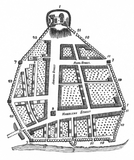
The streets of Albany, New York have had a long history going back almost 400 years. Many of the streets have changed names over the course of time, some have changed names many times. Some streets no longer exist, others have changed course. Some roads existed only on paper. The oldest streets were haphazardly laid out with no overall plan until Simeon De Witt's 1794 street grid plan. The plan had two grids, one west of Eagle Street and the old stockade, and another for the Pastures District south of the old stockade.

Lisha Kill, New York Hamlet in New York, United States

Lisha Kill is a hamlet in the town of Colonie, Albany County, New York, United States. Lisha Kill lies on New York Route 5 in the western section of the town. The hamlet received its name from the creek of the same name, Lisha Kill, kill being Dutch for creek or stream. The stream is also referred to as Lisha's Kill and received its name from a local legend about a Native American woman who is buried along its banks.

Guilderland (hamlet), New York Hamlet in New York, United States

Guilderland is a hamlet of the town of the same name in Albany County, New York, United States.

Normansville, New York Former hamlet in New York, United States

Normansville is a former hamlet in Albany County, New York, United States. In the 19th century, Normansville was a hamlet in the town of Bethlehem. Normansville was located within and along the north and south banks of the ravine carved by the Normans Kill Creek, a tributary of the Hudson River.

Kenwood, Albany, New York Hamlet in New York, United States

Kenwood was a hamlet in the Town of Bethlehem, New York. The hamlet spanned both sides of the Normans Kill near the area where the Normans Kill flows into the Hudson River. In 1870, and again in 1910, northern portions of Kenwood were annexed by the City of Albany, New York.

South Bethlehem, New York Hamlet in New York, United States

South Bethlehem is a hamlet in the town of Bethlehem, Albany County, New York, United States. The hamlet sits on New York State Route 396 and lies southwest of the Selkirk Rail Yard and just north of the Coeymans town line.

New Salem, New York Hamlet in New York, United States

New Salem is a hamlet in the town of New Scotland, Albany County, New York, United States. It is located in a valley at the foot of the Helderberg Escarpment along New York State Route 85. A local fair and car show is held every year in this small hamlet. It is also home to the town of New Scotland's community center and museum.

Clarksville, Albany County, New York Hamlet in New York, United States

Clarksville is a hamlet in the town of New Scotland, Albany County, New York, United States. It is situated along Delaware Turnpike in the southern part of the town at the foot of the Helderberg Escarpment. It is the site of the Clarksville Cave and has an annual Clarksville Heritage Day and Car Show. It is in the Onesquethaw Volunteer Fire Company fire protection district.

Hurstville, New York Place in New York, United States

Hurstville is a former hamlet in the town of Bethlehem, New York. Today it is part of the city of Albany. Hurstville was located in the area of a bend in the Albany, Rensselaerville, and Schoharie Turnpike at its intersections with Whitehall and Krumkill roads, just outside the city limits of Albany.

References

  1. George Howell and Jonathan Tenney (1886). Bi-Centennial History of Albany: History of the County of Albany from 1609-1886; Volume II. W.W. Munsell and Company. pp. 790–791. Retrieved 2010-03-09.
  2. Laws of the State of New York Passed at the Seventy-Seventh Session of the Legislature, Begun the Third Day of January, and Ended the Seventeenth Day of April, 1854, at the City of Albany. State of New York/Gould, Banks & Co./Banks, Gould & Co. 1854. pp. 648–649. Retrieved 2010-03-10.
  3. 1 2 George Howell and Jonathan Tenney (1886). Bi-Centennial History of Albany: History of the County of Albany from 1609-1886; Volume II. W.W. Munsell and Company. p. 781. Retrieved 2010-02-10.
  4. George Howell and Jonathan Tenney (1886). Bi-Centennial History of Albany: History of the County of Albany from 1609-1886; Volume II. W.W. Munsell and Company. p. 791. Retrieved 2010-02-10.
  5. Frederick Hills (1906). New York State Men: Biographic Studies and Character Portraits. The Argus Company. p. 154. Retrieved 2010-03-10.
  6. Barbara Hayden (July 26, 1990). "Changing Times Former Postmaster Remembers When". Albany Times Union. p. B10. Retrieved 2010-03-10.
  7. 1 2 Barbara Hayden (June 2, 1989). "Slingerlands Awaits New Post Office". Albany Times Union. p. B6. Retrieved 2010-03-10.
  8. Automobile Legal Association (ALA) Automobile Green Book, 1930/31 and 1931/32 editions, (Scarborough Motor Guide Co., Boston, 1930 and 1931). The 1930/31 edition shows New York state routes prior to the 1930 renumbering
  9. New York (Map) (1969–70 ed.). Cartography by General Drafting. Esso. 1968.
  10. 1 2 Ken Thurman (May 5, 1987). "Bethlehem Bypass Strategy Draws Outcry From Citizens". Albany Times Union. p. B1. Retrieved 2010-03-10.
  11. Laurence S. Moss, ed. (2001). City and Country (map). American Journal of Economics and Sociology, Inc./Blackwell Publishers. p. 201. ISBN   0-631-22884-5.
  12. Christen Gowan (October 12, 2009). "Roundabout Reduces Injuries, DOT Says". Albany Times Union. Retrieved 2010-03-10.
  13. Iliana Jones (August 12, 1991). "Bethlehem Has More Than its Share of Neighborhood Groups". Albany Times Union. p. B2. Retrieved 2010-03-10.
  14. Barbara Hayden (March 1, 1989). "Homeowners Oppose Shopping Center Plan". Albany Times Union. p. B2. Retrieved 2010-03-10.
  15. Craig Brandon (May 23, 1987). "Vintage Train in Movie". Albany Times Union. p. B1. Retrieved 2010-03-10.
  16. 1 2 3 "Slingerlands Houses to be Open For Tour". Albany Times Union. September 18, 1992. p. C4. Retrieved 2010-03-10.
  17. "National Register of Historic Places Listings". Weekly List of Actions Taken on Properties: 4/16/12 through 4/20/12. National Park Service. 2012-04-27.
  18. "National Register Information System". National Register of Historic Places . National Park Service. July 9, 2010.
  19. 1 2 3 4 Frances Ingraham (October 18, 1992). "Elegant Homes Still Built in Slingerlands". Albany Times Union. p. G1. Retrieved 2010-03-10.[ permanent dead link ]
  20. 12159 SLINGERLANDS New York NY | Free ZIP Code Lookup Archived 2006-09-03 at the Wayback Machine
  21. Frances Ingraham (July 21, 1991). "A Peek at Old, New Slingerlands Home Open for Tour". Albany Times Union. p. G7. Retrieved 2010-03-10.