
The Big Rocky Fork Covered Bridge is located 1 mile (1.6 km) southeast of Mansfield, Indiana, on County Road 720 and about 2 miles (3.2 km) east of State Road 59, in Parke County.

Conley's Ford Covered Bridge was built in 1906 and crosses Big Raccoon Creek on County Road 550 East close to County Road 720 South, in Parke County, IN. The bridge is a single span Burr Arch Truss structure. The Conley's Ford Covered Bridge was built by J. Lawrence Van Fossen.

The McAllister Covered Bridge is a Burr Arch structure that was built by Joseph A. Britton and Son in 1914. It is 144 feet (44 m) long, 16 feet (4.9 m) wide, and 14 feet (4.3 m) high. It is found in Adams Township, Parke County, Indiana, United States.

The Bowsher Ford Covered Bridge is a single span Burr Arch truss covered bridge structure that was built by J.A. Britton's son, Eugene Britton, in 1915.

The Cox Ford Covered Bridge is a covered bridge that crosses Sugar Creek along the western edge of Turkey Run State Park, in Parke County, in the U.S. state of Indiana.

The Jeffries Ford Covered Bridge was southwest of Bridgeton, Indiana, United States. The double-span Burr Arch covered bridge structure was built by J. A. Britton in 1915 and destroyed by arson on April 2, 2002.

The Mecca Covered Bridge crossing Big Raccoon Creek East of Mecca, Indiana is a single span Burr Arch Truss covered bridge structure that was built by J. J. Daniels in 1873. The bridge is 176 feet (54 m) long, 17 feet (5.2 m) wide, and 12.5 feet (3.8 m) high.
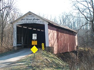
The Mill Creek Covered Bridge also known as "Thompson's Ford Covered Bridge," "Tow Path Covered Bridge," or "Earl Ray Covered Bridge" crosses Wabash Mill Creek (historic) southwest of Tangier, Indiana. It is a single span Burr Arch Truss covered bridge structure that was built by D. M. Brown in 1907.

The Sim Smith Covered Bridge is east of Montezuma, Indiana. The single span Burr Truss covered bridge structure was built by Joseph A. Britton in 1883. The bridge is 101 feet (31 m) long, 16 feet (4.9 m) wide, and 14 feet (4.3 m) high.

The Thorpe Ford Covered Bridge is northeast of Rosedale, Indiana. The single span Burr Arch Truss covered bridge structure was built by Joseph A. Britton in 1912.

The Wilkins Mill Covered Bridge is north of Rockville, Indiana. The single span Burr Arch Truss covered bridge structure was built by William Hendricks in 1906. The bridge is 120 feet (37 m) long, 16 feet (4.9 m) wide, and 13 feet (4.0 m) high.
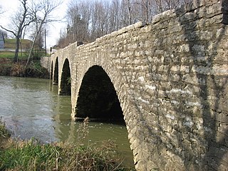
Champ's Ford Bridge, also known as Decatur County Bridge #124, is a historic stone arch bridge located in Clay Township, Decatur County, Indiana. It was built in 1904, and consists of four segmental arches constructed of Indiana Laurel limestone. It measures 118 feet long and 17 feet, 4 inches, wide.
Benville Bridge, also known as Bridge #27, is a historic stone-arch bridge located on the grounds of Jefferson Proving Ground in Bigger Township, Jennings County, Indiana. It was built in 1908, and is a three-span, round arch bridge. It is 168 feet in length and 17 feet wide. It was rehabilitated in 1986.

Paw Paw Creek Bridge No. 52 was a historic Bow-String arch bridge located in Richland Township, Miami County, Indiana. It was built in 1874 by the Wrought Iron Bridge Company and spanned Paw Paw Creek. It was a single-span wrought iron structure with an overall length of 111 feet and width of 21 feet.. The bridge was disassembled after a tree fell on it.
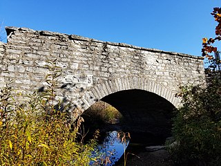
Marble Creek Bridge, also known as Bridge #25, is a historic stone arch bridge located within Big Oaks National Wildlife Refuge in Shelby Township, Ripley County, Indiana. It was built about 1905, and is a one-span, round-arch bridge constructed of limestone. It measures 36 feet long and is 21 feet wide. The property was acquired by the U.S. Army in 1941.

Collin's Ford Bridge, also known as Bridge #28, is a historic stone arch bridge located within Big Oaks National Wildlife Refuge in Shelby Township, Ripley County, Indiana. It was built about 1907, and is a two-span, round-arch bridge constructed of limestone. It measures 108 feet long and is 17 feet wide. The property was acquired by the U.S. Army in 1941.

Straber Ford Bridge, also known as Ripley County Bridge #173, is a historic stone arch bridge located in Center Township, Ripley County, Indiana, United States. It was built in 1908, and is a four-span, semicircular-arch bridge constructed of limestone. It measures 105 feet, 8 inches, long and is 20 feet wide.

Norris Ford Covered Bridge is a historic covered bridge located near Rushville, Indiana in Rushville Township, Rush County, Indiana. It was built in 1916 by Emmett L. Kennedy and his sons Karl and Charles. It is a Burr Arch bridge, 154 feet (47 m) long over Big Flat Rock Creek. The bridge has rounded arch portals and does not have the decorative scrollwork and brackets that are signatures of the Kennedy firm, due to them being out of vogue by 1916.

Middletown Bridge, also known as Shelby County Bridge #149, is a historic stone arch bridge located in Liberty Township, Shelby County, Indiana. It was built in 1903, and is a four-arch bridge constructed of Indiana limestone. It measures 140.8 feet long and 20 feet wide, including the parapet walls. The bridge was torn down by the county in the summer of 2018.

Possum Bottom Covered Bridge, also known as the Jackson's Ford Bridge and Hillsdale Bridge, is a historic Burr Arch Truss covered bridge located in Helt Township, Vermillion County, Indiana. It was built in 1876, and is a single span covered timber bridge. It measures 131 feet long and 14 feet wide. It was moved to its present location at the Ernie Pyle Rest Park in 1972.


