Gilman, Iowa

Last updated

Gilman, Iowa
Marshall County Iowa Incorporated and Unincorporated areas Gilman Highlighted.svg
Location of Gilman, Iowa
Coordinates: 41°52′47″N92°47′20″W / 41.87972°N 92.78889°W / 41.87972; -92.78889
Country Flag of the United States.svg  United States
State Flag of Iowa.svg  Iowa
County Marshall
Area
[1]
  Total0.54 sq mi (1.39 km2)
  Land0.54 sq mi (1.39 km2)
  Water0.00 sq mi (0.00 km2)
Elevation
1,027 ft (313 m)
Population
 (2020)
  Total542
  Density1,011.19/sq mi (390.67/km2)
Time zone UTC-6 (Central (CST))
  Summer (DST) UTC-5 (CDT)
ZIP code
50106
Area code 641
FIPS code 19-30900
GNIS feature ID0456902
Website https://gilman.ia.gov/

Gilman is a city in the southeastern corner of Marshall County, Iowa, United States. The population was 542 at the time of the 2020 census. [2]

Contents

History

Gilman got its start in the year 1870, following construction of the Central Railroad of Iowa through the territory. [3] The town is named for Charles Gilman, a railroad contractor. Gilman was incorporated in 1876. [4] [5]

Geography

Gilman is located at 41°52′47″N92°47′20″W / 41.879750°N 92.788786°W / 41.879750; -92.788786 (41.879750, -92.788786). [6]

According to the United States Census Bureau, the city has a total area of 0.54 square miles (1.40 km2), all land. [7]

Demographics

Historical populations
YearPop.±%
1880 553    
1890 473−14.5%
1900 465−1.7%
1910 430−7.5%
1920 490+14.0%
1930 428−12.7%
1940 483+12.9%
1950 508+5.2%
1960 491−3.3%
1970 513+4.5%
1980 642+25.1%
1990 586−8.7%
2000 600+2.4%
2010 509−15.2%
2020 542+6.5%
Source: "U.S. Census website". United States Census Bureau . Retrieved March 28, 2020. and Iowa Data Center
Source:
U.S. Decennial Census [8] [2]
The population of Gilman, Iowa from US census data GilmanIowaPopPlot.png
The population of Gilman, Iowa from US census data

2010 census

At the 2010 census there were 509 people in 233 households, including 142 families, in the city. The population density was 942.6 inhabitants per square mile (363.9/km2). There were 253 housing units at an average density of 468.5 per square mile (180.9/km2). The racial makup of the city was 99.6% White, 0.2% from other races, and 0.2% from two or more races. Hispanic or Latino of any race were 0.8%. [9]

Of the 233 households 28.8% had children under the age of 18 living with them, 48.1% were married couples living together, 11.6% had a female householder with no husband present, 1.3% had a male householder with no wife present, and 39.1% were non-families. 34.8% of households were one person and 15% were one person aged 65 or older. The average household size was 2.18 and the average family size was 2.83.

The median age was 42.6 years. 23.6% of residents were under the age of 18; 5.3% were between the ages of 18 and 24; 24.2% were from 25 to 44; 30.1% were from 45 to 64; and 16.9% were 65 or older. The gender makeup of the city was 48.7% male and 51.3% female.

2000 census

At the 2000 census there were 600 people in 248 households, including 162 families, in the city. The population density was 1,099.0 inhabitants per square mile (424.3/km2). There were 259 housing units at an average density of 474.4 per square mile (183.2/km2). The racial makup of the city was 99.50% White, and 0.50% from two or more races. Hispanic or Latino of any race were 0.33%. [10]

Of the 248 households 32.7% had children under the age of 18 living with them, 53.2% were married couples living together, 10.1% had a female householder with no husband present, and 34.3% were non-families. 29.4% of households were one person and 14.5% were one person aged 65 or older. The average household size was 2.42 and the average family size was 2.98.

27.5% were under the age of 18, 5.3% from 18 to 24, 27.0% from 25 to 44, 23.3% from 45 to 64, and 16.8% were 65 or older. The median age was 39 years. For every 100 females, there were 92.9 males. For every 100 females age 18 and over, there were 82.8 males.

The median household income was $33,523 and the median family income was $42,500. Males had a median income of $35,000 versus $20,250 for females. The per capita income for the city was $15,070. About 9.9% of families and 12.7% of the population were below the poverty line, including 18.9% of those under age 18 and 8.9% of those age 65 or over.

Education

East Marshall Community School District serves the community. [11] The district was established on July 1, 1992 by the merger of the LDF and SEMCO school districts. [12]

See also

Related Research Articles

<span class="mw-page-title-main">Lanesboro, Iowa</span> City in Iowa, United States

Lanesboro is a city in Carroll County, Iowa, United States. The population was 119 at the time of the 2020 census.

<span class="mw-page-title-main">Grand River, Iowa</span> City in Iowa, United States

Grand River is a city in northwest Decatur County, Iowa, United States. The population was 196 at the time of the 2020 census.

<span class="mw-page-title-main">Van Wert, Iowa</span> City in Iowa, United States

Van Wert is a city in northern Decatur County, Iowa, United States. The population was 178 at the time of the 2020 census.

<span class="mw-page-title-main">Grundy Center, Iowa</span> City in Iowa, United States

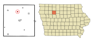
Grundy Center is a city in Grundy County, Iowa. The population was 2,796 at the time of the 2020 census, a 7.7% increase from 2,596 at the 2000 census. Grundy Center is also the county seat of Grundy County. Grundy Center is part of the Waterloo–Cedar Falls Metropolitan Statistical Area.

<span class="mw-page-title-main">Hillsboro, Iowa</span> City in Iowa, United States

Hillsboro is a city in Henry County, Iowa, United States. The population was 163 at the time of the 2020 census.

<span class="mw-page-title-main">Wyoming, Iowa</span> City in Iowa, United States

Wyoming is a city in Jones County, Iowa, United States. The population was 523 at the time of the 2020 census. It is part of the Cedar Rapids Metropolitan Statistical Area.

<span class="mw-page-title-main">Columbus City, Iowa</span> City in Iowa, United States

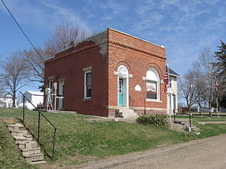
Columbus City is a city in western Louisa County, Iowa, United States. The population was 392 at the 2020 census. It is part of the Muscatine Micropolitan Statistical Area.

<span class="mw-page-title-main">Cotter, Iowa</span> City in Iowa, United States

Cotter is a city in western Louisa County, Iowa, United States. The population was 39 at the 2020 census. It is part of the Muscatine Micropolitan Statistical Area.

<span class="mw-page-title-main">Oakville, Iowa</span> City in Iowa, United States

Oakville is a city in southeasern Louisa County, Iowa, United States. The population was 200 at the time of the 2020 census. It is part of the Muscatine Micropolitan Statistical Area.

<span class="mw-page-title-main">Patterson, Iowa</span> City in Iowa, United States

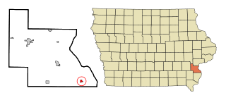
Patterson is a city in Madison County, Iowa, United States. The population was 176 at the time of the 2020 census. It is part of the Des Moines–West Des Moines Metropolitan Statistical Area.

<span class="mw-page-title-main">Orchard, Iowa</span> City in Iowa, United States

Orchard is a city in Mitchell County, Iowa, United States. The population was 68 at the time of the 2020 census.

<span class="mw-page-title-main">Stanton, Iowa</span> City in Iowa, United States

Stanton is a city in Montgomery County, Iowa, United States. The population was 678 at the time of the 2020 census.

<span class="mw-page-title-main">Ruthven, Iowa</span> City in Iowa, United States

Ruthven is a city in Palo Alto County, Iowa, United States. The population was 725 at the time of the 2020 census.

<span class="mw-page-title-main">Havelock, Iowa</span> City in Iowa, United States

Havelock is a city in Pocahontas County, Iowa, United States. The population was 130 at the time of the 2020 census.

<span class="mw-page-title-main">Westphalia, Iowa</span> City in Iowa, United States

Westphalia is a city in Shelby County, Iowa, United States. The population was 126 at the time of the 2020 census.

<span class="mw-page-title-main">Spring Hill, Iowa</span> City in Iowa, United States

Spring Hill is a city in Warren County, Iowa, United States. The population was 68 at the time of the 2020 census. It is part of the Des Moines–West Des Moines Metropolitan Statistical Area.

<span class="mw-page-title-main">St. Marys, Iowa</span> City in Iowa, United States

St. Marys or Saint Marys is a city in Warren County, Iowa, United States. The population was 108 at the time of the 2020 census.

<span class="mw-page-title-main">Crawfordsville, Iowa</span> City in Iowa, United States

Crawfordsville is a city in Washington County, Iowa, United States. It is part of the Iowa City, Iowa Metropolitan Statistical Area. The population was 277 at the 2020 census.

<span class="mw-page-title-main">West Chester, Iowa</span> City in Iowa, United States

West Chester is a city in Washington County, Iowa, United States. It is part of the Iowa City, Iowa Metropolitan Statistical Area. The population was 144 at the time of the 2020 census.

<span class="mw-page-title-main">Kensett, Iowa</span> City in Iowa, United States

Kensett is a city in Worth County, Iowa, United States. The population was 257 at the time of the 2020 census. It is part of the Mason City Micropolitan Statistical Area.

References

  1. "2020 U.S. Gazetteer Files". United States Census Bureau. Retrieved March 16, 2022.
  2. 1 2 "2020 Census State Redistricting Data". census.gov. United states Census Bureau. Retrieved August 12, 2021.
  3. The History of Marshall County, Iowa: Containing a History of the County, Its Cities, Towns, &c. Western Historical Co. 1878. pp.  536.
  4. Battin, William (1912). Past and Present of Marshall County, Iowa, Volume 1. Brookhaven Press. p. 178. ISBN   9781581038972.
  5. Gannett, Henry (1905). The Origin of Certain Place Names in the United States. Govt. Print. Off. pp.  137.
  6. "US Gazetteer files: 2010, 2000, and 1990". United States Census Bureau. February 12, 2011. Retrieved April 23, 2011.
  7. "US Gazetteer files 2010". United States Census Bureau. Archived from the original on January 25, 2012. Retrieved May 11, 2012.
  8. "Census of Population and Housing". Census.gov. Retrieved June 4, 2015.
  9. "U.S. Census website". United States Census Bureau . Retrieved May 11, 2012.
  10. "U.S. Census website". United States Census Bureau . Retrieved January 31, 2008.
  11. "East Marshall" (PDF). Iowa Department of Education . Retrieved March 25, 2020.
  12. "REORGANIZATION & DISSOLUTION ACTIONS SINCE 1965-66" (PDF). Iowa Department of Education. Archived from the original (PDF) on February 9, 2019. Retrieved March 22, 2020.

Commons-logo.svg Media related to Gilman, Iowa at Wikimedia Commons