State Center, Iowa | |
---|---|
Nickname: Rose Capital of Iowa | |
Coordinates: 42°0′57″N93°9′51″W / 42.01583°N 93.16417°W | |
Country | United States |
State | Iowa |
County | Marshall |
Area | |
• Total | 1.00 sq mi (2.58 km2) |
• Land | 1.00 sq mi (2.58 km2) |
• Water | 0.00 sq mi (0.00 km2) |
Elevation | 1,070 ft (326 m) |
Population (2020) | |
• Total | 1,391 |
• Density | 1,393.79/sq mi (538.37/km2) |
Time zone | UTC-6 (Central (CST)) |
• Summer (DST) | UTC-5 (CDT) |
ZIP code | 50247 |
Area code | 641 |
FIPS code | 19-75135 |
GNIS feature ID | 0461964 |
Website | http://www.statecenteriowa.org/ |
State Center is a city in Marshall County, Iowa, United States. The population was 1,391 at the time of the 2020 census. [2] State Center is known as the Rose Capital of Iowa. [3]
State Center got its start in the year 1864, following construction of the railroad through the territory. [4] It was named for its location near the geographical center of the state. [5]
According to the United States Census Bureau, the city has a total area of 0.98 square miles (2.54 km2), all land. [6]
Year | Pop. | ±% |
---|---|---|
1870 | 559 | — |
1880 | 880 | +57.4% |
1890 | 854 | −3.0% |
1900 | 1,008 | +18.0% |
1910 | 898 | −10.9% |
1920 | 975 | +8.6% |
1930 | 1,012 | +3.8% |
1940 | 1,033 | +2.1% |
1950 | 1,040 | +0.7% |
1960 | 1,142 | +9.8% |
1970 | 1,232 | +7.9% |
1980 | 1,292 | +4.9% |
1990 | 1,248 | −3.4% |
2000 | 1,349 | +8.1% |
2010 | 1,468 | +8.8% |
2020 | 1,391 | −5.2% |
Source: "U.S. Census website". United States Census Bureau . Retrieved March 29, 2020. and Iowa Data Center Source: |
As of the census [8] of 2010, there were 1,468 people, 568 households, and 399 families living in the city. The population density was 1,498.0 inhabitants per square mile (578.4/km2). There were 630 housing units at an average density of 642.9 per square mile (248.2/km2). The racial makeup of the city was 96.7% White, 0.5% African American, 0.1% Native American, 0.3% Asian, 1.2% from other races, and 1.2% from two or more races. Hispanic or Latino of any race were 3.5% of the population.
There were 568 households, of which 36.6% had children under the age of 18 living with them, 54.9% were married couples living together, 11.3% had a female householder with no husband present, 4.0% had a male householder with no wife present, and 29.8% were non-families. 24.6% of all households were made up of individuals, and 12.7% had someone living alone who was 65 years of age or older. The average household size was 2.52 and the average family size was 3.02.
The median age in the city was 39.2 years. 28.1% of residents were under the age of 18; 5.9% were between the ages of 18 and 24; 23.6% were from 25 to 44; 25.5% were from 45 to 64; and 16.9% were 65 years of age or older. The gender makeup of the city was 49.7% male and 50.3% female.
As of the census [9] of 2000, there were 1,349 people, 559 households, and 354 families living in the city. The population density was 1,384.4 inhabitants per square mile (534.5/km2). There were 597 housing units at an average density of 612.7 per square mile (236.6/km2). The racial makeup of the city was 97.78% White, 0.15% Native American, 0.07% Asian, 1.11% from other races, and 0.89% from two or more races. Hispanic or Latino of any race were 1.85% of the population.
There were 559 households, out of which 29.9% had children under the age of 18 living with them, 53.8% were married couples living together, 5.7% had a female householder with no husband present, and 36.5% were non-families. 33.3% of all households were made up of individuals, and 18.4% had someone living alone who was 65 years of age or older. The average household size was 2.35 and the average family size was 3.00.
25.4% are under the age of 18, 6.7% from 18 to 24, 27.1% from 25 to 44, 20.6% from 45 to 64, and 20.2% who were 65 years of age or older. The median age was 39 years. For every 100 females, there were 90.5 males. For every 100 females age 18 and over, there were 86.8 males.
The median income for a household in the city was $35,766, and the median income for a family was $45,156. Males had a median income of $33,661 versus $25,156 for females. The per capita income for the city was $17,744. About 5.7% of families and 8.7% of the population were below the poverty line, including 15.4% of those under age 18 and 5.7% of those age 65 or over.
West Marshall Community School District operates public schools. The school colors are black and gold, and the mascot is a Trojan. The schools include West Marshall Elementary, West Marshall Middle School, and West Marshall High School. [10]
Harpers Ferry is a city in Taylor Township, Allamakee County, Iowa, United States. The population was 262 at the time of the 2020 census.
Luzerne is a city in Benton County, Iowa, United States. The population was 112 at the time of the 2020 census. It is part of the Cedar Rapids Metropolitan Statistical Area.
Hudson is a city in Black Hawk County, Iowa, United States. The population was 2,546 at the time of the 2020 census. The rural community of Hudson has grown in recent years and is included as a part of the Waterloo-Cedar Falls Metropolitan Statistical Area.
Aurora is a city in Buchanan County, Iowa, United States. The population was 169 in the 2020 census, a decline from 194 in 2000.
Aurelia is a city in Cherokee County, Iowa, United States. The population was 968 at the 2020 census.
Granger is a city in Dallas and Polk counties in the U.S. state of Iowa. The population was 1,654 at the time of the 2020 census, up 184% from 583 in 2000. It is part of the Des Moines–West Des Moines Metropolitan Statistical Area.
Maynard is a city in Fayette County, Iowa, United States. The population was 476 at the time of the 2020 census.
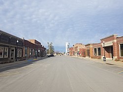
Olds is a city in Henry County, Iowa, United States. The population was 192 at the time of the 2020 census.
Ledyard is a city in Kossuth County, Iowa, United States. The population was 121 at the time of the 2020 census.
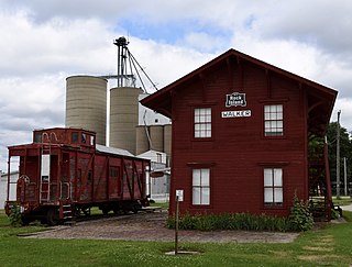
Walker is a city in Linn County, Iowa. The population was 688 at the 2020 census. It is part of the Cedar Rapids, Iowa metropolitan area.
Albion is a city in Marshall County, Iowa, United States. The population was 448 at the 2020 census.
Ferguson is a city in Marshall County, Iowa, United States. The population was 97 at the time of the 2020 census.
Gilman is a city in the southeastern corner of Marshall County, Iowa, United States. The population was 542 at the time of the 2020 census.
Paullina is a city in O'Brien County, Iowa, United States. The population was 982 at the 2020 census.
Neola is a city in Pottawattamie County, Iowa, United States. The population was 918 at the time of the 2020 census.
Ireton is a city in Sioux County, Iowa, United States. The population was 590 at the time of the 2020 census.
Sharpsburg is a city in Taylor County, Iowa, United States. The population was 72 at the time of the 2020 census.
Vincent is a city in Webster County, Iowa, United States. The population was 130 at the time of the 2020 census.
Lake Mills is a city in Winnebago County, Iowa, United States. The population was 2,143 at the time of the 2020 census.
Elkton is a city in Marshall Township, Mower County, Minnesota, United States. The population was 130 at the 2020 census.