Laurel, Iowa | |
---|---|
City | |
Coordinates: 41°53′1″N92°55′22″W / 41.88361°N 92.92278°W | |
Country | United States |
State | Iowa |
County | Marshall |
Area | |
• Total | 0.25 sq mi (0.64 km2) |
• Land | 0.25 sq mi (0.64 km2) |
• Water | 0.00 sq mi (0.00 km2) |
Elevation | 1,043 ft (318 m) |
Population (2020) | |
• Total | 220 |
• Density | 894.31/sq mi (344.66/km2) |
Time zone | UTC-6 (Central (CST)) |
• Summer (DST) | UTC-5 (CDT) |
ZIP code | 50141 |
Area code | 641 |
FIPS code | 19-43680 |
GNIS feature ID | 0458239 |
Laurel is a city in Marshall County, Iowa, United States. The population was 220 at the time of the 2020 census. [2]
Laurel was platted in 1880 by Conrad Weissenburger, and it was incorporated in 1902. [3] The city was named after Laurel, Ohio, by settler Rufus Archerd. [4]
Laurel is located at 41°53′1″N92°55′22″W / 41.88361°N 92.92278°W (41.883720, -92.922906). [5]
According to the United States Census Bureau, the city has a total area of 0.25 square miles (0.65 km2), all land. [6]
East Marshall Community School District serves the community. [7] The district was established on July 1, 1992 by the merger of the LDF and SEMCO school districts. [8]
Year | Pop. | ±% |
---|---|---|
1910 | 179 | — |
1920 | 195 | +8.9% |
1930 | 232 | +19.0% |
1940 | 232 | +0.0% |
1950 | 257 | +10.8% |
1960 | 223 | −13.2% |
1970 | 245 | +9.9% |
1980 | 278 | +13.5% |
1990 | 271 | −2.5% |
2000 | 266 | −1.8% |
2010 | 239 | −10.2% |
2020 | 220 | −7.9% |
Source: "U.S. Census website". United States Census Bureau . Retrieved March 29, 2020. and Iowa Data Center Source: |
As of the census [12] of 2010, there were 239 people, 109 households, and 64 families living in the city. The population density was 956.0 inhabitants per square mile (369.1/km2). There were 122 housing units at an average density of 488.0 per square mile (188.4/km2). The racial makeup of the city was 98.7% White, 0.4% African American, 0.4% Asian, and 0.4% from two or more races. Hispanic or Latino of any race were 2.1% of the population.
There were 109 households, of which 29.4% had children under the age of 18 living with them, 37.6% were married couples living together, 14.7% had a female householder with no husband present, 6.4% had a male householder with no wife present, and 41.3% were non-families. 38.5% of all households were made up of individuals, and 19.3% had someone living alone who was 65 years of age or older. The average household size was 2.19 and the average family size was 2.89.
The median age in the city was 43.8 years. 25.5% of residents were under the age of 18; 5.4% were between the ages of 18 and 24; 20.9% were from 25 to 44; 30.1% were from 45 to 64; and 18% were 65 years of age or older. The gender makeup of the city was 49.8% male and 50.2% female.
As of the census [13] of 2000, there were 266 people, 109 households, and 70 families living in the city. The population density was 1,056.7 inhabitants per square mile (408.0/km2). There were 122 housing units at an average density of 484.7 per square mile (187.1/km2). The racial makeup of the city was 96.24% White, 0.38% Native American, 1.13% Pacific Islander, and 2.26% from two or more races. Hispanic or Latino of any race were 2.63% of the population.
There were 109 households, out of which 26.6% had children under the age of 18 living with them, 54.1% were married couples living together, 7.3% had a female householder with no husband present, and 34.9% were non-families. 32.1% of all households were made up of individuals, and 20.2% had someone living alone who was 65 years of age or older. The average household size was 2.44 and the average family size was 3.00.
In the city, the population was spread out, with 26.3% under the age of 18, 4.9% from 18 to 24, 25.9% from 25 to 44, 25.9% from 45 to 64, and 16.9% who were 65 years of age or older. The median age was 40 years. For every 100 females, there were 97.0 males. For every 100 females age 18 and over, there were 96.0 males.
The median income for a household in the city was $32,031, and the median income for a family was $38,125. Males had a median income of $30,208 versus $17,188 for females. The per capita income for the city was $14,980. About 1.4% of families and 7.0% of the population were below the poverty line, including 9.2% of those under the age of eighteen and 12.2% of those 65 or over.
Prescott is a city in Prescott Township, Adams County, Iowa, United States. The population was 191 at the time of the 2020 census.
Griswold is a city in Cass County, Iowa, United States. The population was 994 at the time of the 2020 census.
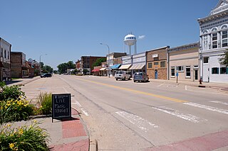
Tipton (/ˈtɪptən/) is a city in Cedar County, Iowa, United States. The population was 3,149 at the time of the 2020 census. It is the county seat of Cedar County.
Drakesville is a city in Davis County, Iowa, United States. The population was 164 at the time of the 2020 census.
Buckeye is a city in Hardin County, Iowa, United States. The population was 86 at the time of the 2020 census.
Kinross is a city in Keokuk County, Iowa, United States. The population was 80 at the time of the 2020 census. The community is named after Kinross in Scotland.
South English is a city in Keokuk County, Iowa, United States. The population was 202 at the time of the 2020 census. It is named for the English River.
Beacon is a city in Mahaska County, Iowa, United States. The population was 445 at the 2020 census.
Emerson is a city in Mills County, Iowa, United States. The population was 403 at the time of the 2020 census.
Dixon is a city in Scott County, Iowa, United States. The population was 202 at the time of the 2020 census.
Donahue is a city in Scott County, Iowa, United States. The population was 335 at the 2020 census. The city has a mayor-council form of government.
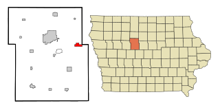
Huxley is a city in Story County, Iowa, United States. The population was 4,244 at the time of the 2020 census. It is part of the Ames, Iowa Metropolitan Statistical Area, which is a part of the larger Ames-Boone, Iowa Combined Statistical Area.
Kelley is a city in Story County, Iowa, United States. The population was 304 at the time of the 2020 census. It is part of the Ames Metropolitan Statistical Area, which is a part of the larger Ames-Boone Combined Statistical Area.
Chelsea is a city in Tama County, Iowa, United States. The population was 229 at the 2020 census. The city is located in the Iowa River Valley and has suffered severe damage in several floods.
Clutier is a city in Tama County, Iowa, United States. The population was 213 at the 2020 census.
Montour is a city in Tama County, Iowa, United States. The population was 203 at the time of the 2020 census.
Conway is a city in Taylor County, Iowa, United States. The population was 17 at the 2020 census.
Duncombe is a city in Webster County, Iowa, United States. The population was 381 at the time of the 2020 census.
Clay Township is a township in Butler County, Pennsylvania, United States. The population was 2,547 at the 2020 census.
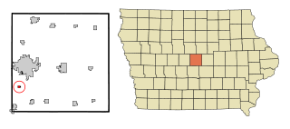
Bevington is a city in Madison and Warren Counties in the U.S. state of Iowa. The population was 57 at the 2020 census. It is part of the Des Moines–West Des Moines Metropolitan Statistical Area.