Liscomb, Iowa | |
---|---|
Coordinates: 42°11′26″N93°0′20″W / 42.19056°N 93.00556°W | |
Country | United States |
State | Iowa |
County | Marshall |
Area | |
• Total | 1.01 sq mi (2.62 km2) |
• Land | 1.01 sq mi (2.62 km2) |
• Water | 0.00 sq mi (0.00 km2) |
Elevation | 1,010 ft (308 m) |
Population (2020) | |
• Total | 291 |
• Density | 288.12/sq mi (111.27/km2) |
Time zone | UTC-6 (Central (CST)) |
• Summer (DST) | UTC-5 (CDT) |
ZIP code | 50148 |
Area code | 641 |
FIPS code | 19-45660 |
GNIS feature ID | 0458430 |
Liscomb is a city in Marshall County, Iowa, United States. The population was 291 at the time of the 2020 census. [2]
Liscomb was platted in 1869. It was named for an official of the Iowa Central Railroad. [3]
Liscomb is located at 42°11′26″N93°0′20″W / 42.19056°N 93.00556°W (42.190610, -93.005662). [4]
According to the United States Census Bureau, the city has a total area of 0.98 square miles (2.54 km2), all land. [5]
Year | Pop. | ±% |
---|---|---|
1880 | 452 | — |
1890 | 313 | −30.8% |
1900 | 338 | +8.0% |
1910 | 354 | +4.7% |
1920 | 347 | −2.0% |
1930 | 326 | −6.1% |
1940 | 340 | +4.3% |
1950 | 278 | −18.2% |
1960 | 295 | +6.1% |
1970 | 328 | +11.2% |
1980 | 296 | −9.8% |
1990 | 258 | −12.8% |
2000 | 272 | +5.4% |
2010 | 301 | +10.7% |
2020 | 291 | −3.3% |
Source: "U.S. Census website". United States Census Bureau . Retrieved March 29, 2020. and Iowa Data Center Source: |
As of the census [7] of 2010, there were 301 people, 118 households, and 82 families living in the city. The population density was 307.1 inhabitants per square mile (118.6/km2). There were 127 housing units at an average density of 129.6 per square mile (50.0/km2). The racial makeup of the city was 93.0% White, 3.0% Asian, 2.7% from other races, and 1.3% from two or more races. Hispanic or Latino of any race were 2.0% of the population.
There were 118 households, of which 36.4% had children under the age of 18 living with them, 51.7% were married couples living together, 9.3% had a female householder with no husband present, 8.5% had a male householder with no wife present, and 30.5% were non-families. 22.0% of all households were made up of individuals, and 11% had someone living alone who was 65 years of age or older. The average household size was 2.55 and the average family size was 2.91.
The median age in the city was 37.5 years. 26.9% of residents were under the age of 18; 8.3% were between the ages of 18 and 24; 23.8% were from 25 to 44; 25.8% were from 45 to 64; and 15% were 65 years of age or older. The gender makeup of the city was 48.8% male and 51.2% female.
As of the census [8] of 2000, there were 272 people, 113 households, and 72 families living in the city. The population density was 276.6 inhabitants per square mile (106.8/km2). There were 125 housing units at an average density of 127.1 per square mile (49.1/km2). The racial makeup of the city was 98.16% White, 0.37% Native American, and 1.47% from two or more races.
There were 113 households, out of which 31.0% had children under the age of 18 living with them, 54.0% were married couples living together, 7.1% had a female householder with no husband present, and 35.4% were non-families. 31.0% of all households were made up of individuals, and 17.7% had someone living alone who was 65 years of age or older. The average household size was 2.41, and the average family size was 3.00.
Age spread: 25.0% under the age of 18, 7.7% from 18 to 24, 28.7% from 25 to 44, 22.1% from 45 to 64, and 16.5% who were 65 years of age or older. The median age was 39 years. For every 100 females, there were 90.2 males. For every 100 females age 18 and over, there were 100.0 males.
The median income for a household in the city was $40,000, and the median income for a family was $41,071. Males had a median income of $28,750 versus $21,667 for females. The per capita income for the city was $16,678. About 9.2% of families and 8.1% of the population were below the poverty line, including 5.2% of those under the age of eighteen and 10.3% of those 65 or over.
BCLUW Community School District operates public schools serving Liscomb. The schools are BCLUW Elementary School in Conrad, BCLUW Middle School in Union, and BCLUW High School in Conrad.
The Beaman-Conrad-Liscomb school district served Liscomb until July 1, 1992, when it merged into BCLUW. [9]
Marshall County is a county located in the U.S. state of Iowa. As of the 2020 census, the population was 40,105. The county seat and largest city is Marshalltown. The county was formed on January 13, 1846, and named after John Marshall, Chief Justice of the United States Supreme Court. Marshall County comprises the Marshalltown, Iowa Micropolitan Statistical Area. In 2010, the center of population of Iowa was located in Marshall County, near Melbourne.
Osburn is a city in Shoshone County, Idaho, United States. Located in the Silver Valley mining region of northern Idaho, its population was 1,555 at the 2010 census.
Bridgewater is a city in Jackson Township, Adair County, Iowa, United States. The population was 148 at the time of the 2020 census. Bridgewater was founded in 1885.
Plymouth is a city in Cerro Gordo County, Iowa, United States, along the Shell Rock River. The population was 375 at the time of the 2020 census. It is part of the Mason City Micropolitan Statistical Area.
Rock Falls is a city in Cerro Gordo County, Iowa, United States, along the Shell Rock River. The population was 150 at the time of the 2020 census. It is part of the Mason City Micropolitan Statistical Area.
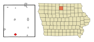
Geneva is a city in Franklin County, Iowa, United States. The population was 136 at the time of the 2020 census.
Beaman is a city in Grundy County, Iowa, United States. The population was 161 at the 2020 census. It is part of the Waterloo−Cedar Falls Metropolitan Statistical Area.
Conrad is a city in Grundy County, Iowa, United States. The population was 1,093 at the 2020 census. It is part of the Waterloo–Cedar Falls Metropolitan Statistical Area. Conrad holds the honor of being known as the "Black Dirt Capital of the World."
Bagley is a town in Guthrie County, Iowa, United States. The population was 233 in the 2020 census, a decline from 354 in 2000 census. It is part of the Des Moines–West Des Moines Metropolitan Statistical Area.
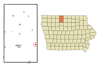
Kanawha is a city in Hancock County, Iowa, United States. The population was 658 at the time of the 2020 census.
Woden is a city in Hancock County, Iowa, United States. The population was 188 at the time of the 2020 census.
Union is a city in Hardin County, Iowa, United States. The population was 399 at the time of the 2020 census.
Whitten is a city in Hardin County, Iowa, United States. The population was 100 at the time of the 2020 census.
Reasnor is a city in Jasper County, Iowa, United States. The population was 152 at the time of the 2020 census.
Wesley is a city in Kossuth County, Iowa, United States. The population was 391 at the time of the 2020 census.
Center Point is a city in Linn County, Iowa, United States. The population was 2,579 at the 2020 census. It is part of the Cedar Rapids Metropolitan Statistical Area.
Patterson is a city in Madison County, Iowa, United States. The population was 176 at the time of the 2020 census. It is part of the Des Moines–West Des Moines Metropolitan Statistical Area.
Huxley is a city in Story County, Iowa, United States. The population was 4,244 at the time of the 2020 census. It is part of the Ames, Iowa Metropolitan Statistical Area, which is a part of the larger Ames-Boone, Iowa Combined Statistical Area.
McCallsburg is a city in Story County, Iowa, United States. The population was 353 at the time of the 2020 census. It is part of the Ames, Iowa Metropolitan Statistical Area, which is a part of the larger Ames-Boone, Iowa Combined Statistical Area.
Litchville is a city in Barnes County, North Dakota, United States. The population was 169 at the 2020 census. Litchville was founded in 1900.