List of territorial disputes

Last updated

Disputed territories shown in red Map of Territorial Disputes.svg
Disputed territories shown in red

Territorial disputes have occurred throughout history, over lands around the world. Bold indicates one claimant's full control; italics indicates one or more claimants' partial control.

Contents

Ongoing disputes between UN member/observer states

Africa

TerritoryClaimantsNotes
Abyei, Jodha, Kafia Kingi and KakaFlag of Sudan.svg  Sudan
Flag of South Sudan.svg  South Sudan
Both Sudan and South Sudan have claimed the area after the civil war that led to South Sudan's independence. Heglig was controlled by South Sudan in mid-April 2012, but retaken by Sudan.
Banc du Geyser Flag of Madagascar.svg  Madagascar
Flag of the Comoros.svg  Comoros
Flag of France.svg  France
Scattered Islands in the Indian Ocean, a district of the French Southern Territories.
Bassas da India, Europa Island and Juan de Nova Island Flag of France.svg  France
Flag of Madagascar.svg  Madagascar [1]
De facto part of the French overseas territory of the French Southern Territories.
Ceuta, [2] Melilla, and other plazas de soberanía Flag of Spain.svg  Spain
Flag of Morocco.svg  Morocco
Ceuta and Melilla are administered by Spain as autonomous cities.
After an incident on Perejil Island in 2002, both countries agreed to return to the status quo . [3]
Chagos Archipelago Flag of the United Kingdom.svg  United Kingdom
Flag of Mauritius.svg  Mauritius
The United Kingdom administers the archipelago as part of the British Indian Ocean Territory. An advisory opinion of the International Court of Justice has found the United Kingdom administration to be unlawful and called upon the United Kingdom to complete the process of decolonization with respect to Mauritius.
Doumeira Mountain, Ras Doumeira and Doumeira Island Flag of Eritrea.svg  Eritrea
Flag of Djibouti.svg  Djibouti
Basis of the Djiboutian–Eritrean border conflict of 2008. Disputed territory occupied by Eritrea following withdrawal of Qatari peacekeepers in June 2017. [4] [5] Alternatively transliterated as the Dumaira Mountains. [4]
Glorioso Islands Flag of France.svg  France
Flag of Madagascar.svg  Madagascar
Flag of the Comoros.svg  Comoros
De facto a part of the French overseas territory of the French Southern Territories.
Hala'ib Triangle Flag of Egypt.svg  Egypt
Flag of Sudan.svg  Sudan [6]
Previously under joint administration; Egypt now maintains full de facto control of the Hala'ib Triangle. The boundaries claimed by Egypt and Sudan both include the Hala'ib Triangle. The area of Bir Tawil close to the triangle is unclaimed by both countries.
Ilemi Triangle Flag of Kenya.svg  Kenya
Flag of South Sudan.svg  South Sudan
De facto controlled by Kenya. Ethiopian tribes used and made raids in the land, but the Ethiopian government has never made a claim to it, agreeing it was Sudanese in 1902, 1907, and 1972 treaties. [7] [8] [9]
KaNgwane and Ingwavuma Flag of South Africa.svg  South Africa
Flag of Eswatini.svg  Eswatini
Eswatini claims territories that it states were confiscated during colonial times. [10] The area claimed by Eswatini is the former bantustan of KaNgwane, which now forms the northern parts of Jozini and uMhlabuyalingana local municipalities in KwaZulu-Natal, and the southern part of Nkomazi, the southeastern part of Umjindi and the far eastern part of Albert Luthuli local municipalities in Mpumalanga.
Koalou village and surrounding areaFlag of Burkina Faso.svg  Burkina Faso
Flag of Benin.svg  Benin
Burkina Faso and Benin retain a border dispute at this 7.75  km2 triangular area of land near the tripoint border with Togo. [11] [12] In a 2008 meeting, it was declared that the territory was a neutral zone, neither Burkinabé nor Beninese, making it technically unclaimed. [11] According to the UN Refugee Agency in 2015, there were issues of children being born stateless in the area, however, a Beninese civil registration office has taken control of registering births in the area. [13]
Kpéaba village area (near Sipilou/Siquita)Flag of Cote d'Ivoire.svg  Ivory Coast
Flag of Guinea.svg  Guinea
The Guinean military occupied this village for 1 month from January to February 2013, before withdrawing in preparation for talks. [14] In December 2016, Guinea soldiers and civilians attacked the village, killing 1 and wounding several others, before returning to their side of the border. [15] According to the Guinean Minister of Defence, the Guinean army had been asked not to send any soldiers to this area and had no involvement in this incident. [16]
Area near Logoba/Moyo District Flag of South Sudan.svg  South Sudan
Flag of Uganda.svg  Uganda
A 1914 British colonial order defined the international border based on the tribal boundary between the Kuku of Kajokeji (South Sudan) and the Ma'di of Moyo (Uganda). However, the border was never formally demarcated. [17] In 2014, a conflict was triggered by the Ugandan national census when Ugandan officials were detained by South Sudan authorities. [18]
Area near Chiengi, Lunchinda-Pweto Province Flag of Zambia.svg  Zambia
Flag of the Democratic Republic of the Congo.svg  DR Congo
Zambia and Congo have different interpretations of the borders set out in an 1894 treaty between British settlers and Leopold II, King of the Belgians. There have been incidents between the armies of both countries in 1996, 2006, and 2016. In March 2020, Zambia deployed troops on the Congolese side of the border. [19]
Right bank of the Lunkinda River (near the village of Pweto) [20] Flag of the Democratic Republic of the Congo.svg  DR Congo
Flag of Zambia.svg  Zambia
Mayotte Flag of France.svg  France
Flag of the Comoros.svg  Comoros [1]
Under the 2009 referendum, the population supported becoming an overseas department of France, so Mayotte became one on March 31, 2011.
Islands in Mbamba Bay, Lake Nyasa Flag of Tanzania.svg  Tanzania
Flag of Malawi.svg  Malawi
Lundo Is. and Mbamba Is. are claimed as part of the lake, as Malawi has claims to the shore − based on the 1890 Anglo-German treaty. See Tanzania–Malawi dispute.
Mbañie Island  [ es ], Cocotiers and Congas IslandFlag of Gabon.svg  Gabon
Flag of Equatorial Guinea.svg  Equatorial Guinea
Contested islands in Corisco Bay, valuable for their oil. [21] [22]
Several islands in the Congo River Flag of the Republic of the Congo.svg  Republic of the Congo
Flag of the Democratic Republic of the Congo.svg  DR Congo
Most of the boundary in the Congo River remains undefined. [23]
An island in the Ntem River Flag of Cameroon.svg  Cameroon
Flag of Equatorial Guinea.svg  Equatorial Guinea
[24]
Several villages near the Okpara River Flag of Benin.svg  Benin
Flag of Nigeria.svg  Nigeria
The Rufunzo Valley and SabanerwaFlag of Rwanda.svg  Rwanda
Flag of Burundi.svg  Burundi
In 1965, the Akanyaru River changed course due to heavy rains. Burundians point to Rwandan farmers for contributing to the change of course by rice-growing. [25]
Rukwanzi Island and the Semliki River valleyFlag of the Democratic Republic of the Congo.svg  DR Congo
Flag of Uganda.svg  Uganda
The dispute is related to fishing rights in Lake Edward and Lake Albert. [26]
Sindabezi IslandFlag of Zambia.svg  Zambia
Flag of Zimbabwe.svg  Zimbabwe [27]
Tourist island on the Zambezi River, west of the Victoria Falls
Tromelin Island Flag of France.svg  France
Flag of Mauritius.svg  Mauritius
Flag of Madagascar.svg  Madagascar
De facto a part of the French overseas territory of the French Southern Territories.
Wadi Halfa Salient Flag of Egypt.svg  Egypt
Flag of Sudan.svg  Sudan
Most of the disputed territory comprised villages flooded by Lake Nasser after the construction of the Aswan Dam. [28]
Territory east of the Oued Tourndo  [ ceb ]Flag of Algeria.svg  Algeria
Flag of Libya.svg  Libya
Libya claims 32,000 square kilometers of southeastern Algeria, south of the Libyan town of Ghat. [29] [30] [31]

Americas

North America

TerritoryClaimantsNotes
Bajo Nuevo Bank and Serranilla Bank Flag of Colombia.svg  Colombia
Flag of Honduras.svg  Honduras
Flag of the United States (23px).png  United States
Jamaica and Nicaragua have recognized the sovereignty of Colombia; other claimants have not. On November 19, 2012, the International Court of Justice (ICJ) ruled that Colombia has sovereignty over Bajo Nuevo Bank and Serranilla. [32] Honduras implicitly recognized Colombian sovereignty in a 1999 maritime delimitation treaty, but continues to claim the two banks in its constitution. [33]
Conejo Island Flag of Honduras.svg  Honduras
Flag of El Salvador.svg  El Salvador
Navassa Island [1] Flag of the United States (23px).png  United States
Flag of Haiti.svg  Haiti
The U.S. has claimed the island since 1857, based on the Guano Islands Act of 1856. [34] Haiti's claim over Navassa goes back to the Treaty of Ryswick in 1697 that established French possessions in mainland Hispaniola, which were transferred from Spain by the treaty as well as other specifically named nearby islands.
Sapodilla Cayes Flag of Belize.svg  Belize
Flag of Guatemala.svg  Guatemala
Flag of Honduras.svg  Honduras
Guatemala formally claims all of Belize; an International Court of Justice decision over the matter is pending.
Belizean-Guatemalan territorial dispute Flag of Belize.svg  Belize
Flag of Guatemala.svg  Guatemala
The Guatemalan Ministry of Foreign Affairs has issued a statement in which Guatemala specifically claims territory between the Sibun and Sarstoon rivers, which makes up around half of Belizean-administered territory. However, Guatemala also claims all of Belize because its historical recognition of British Honduras was contingent on the construction of a road between Guatemala City and the Atlantic Ocean which was never built, an apparent violation of the Wyke-Aycinena Treaty. An International Court of Justice decision over the matter is pending. [35]
Territorial disputes between Canada and the United States
Territory Flag of Canada (Pantone).svg Canadian claimant Flag of the United States.svg U.S. claimant
Machias Seal Island New Brunswick Maine
North Rock

South America

TerritoryClaimantsNotes
Guyana–Venezuela territorial dispute (Guyana west of the Essequibo River) and Ankoko Island Flag of Guyana.svg  Guyana
Flag of Venezuela.svg  Venezuela
Approximately two-thirds of Guyana's sovereign territory is claimed by Venezuela. Following arbitration, a demarcated border was established in 1905 following the Arbitral Award of 1899 but was later contested by Venezuela in 1962 following the publication of the Mallet-Prevost memorandum. The crisis was renewed recently following the discovery of oil deposits.
Arroyo de la Invernada or Rincón de Artigas and Vila Albornoz Flag of Brazil.svg  Brazil
Flag of Uruguay.svg  Uruguay
Dispute in the 237 km2 Invernada River region near Masoller, over which tributary represents the legitimate source of the Quaraí River/Cuareim River. The UN does not officially recognize the claim.[ clarification needed ]
Falkland Islands [1] Flag of the United Kingdom.svg  United Kingdom
Flag of Argentina.svg  Argentina
See Falkland Islands sovereignty dispute
French Guiana and Suriname involving the Maroni River Flag of France.svg  France
Flag of Suriname.svg  Suriname
The source or tributary of the Lawa River between Suriname and French Guiana is disputed but eventually follows to the tripoint with Brazil. The Netherlands, and now Suriname, contends that the boundary follows the Malani River to the east, while France asserts that the border follows the Litani River to the west.
New River Triangle (Tigri Area) involving the Courantyne River and the New River Flag of Guyana.svg  Guyana
Flag of Suriname.svg  Suriname
The New River Triangle (also known as the Tigri Area) is a region within the Guiana Highlands that has been disputed by Suriname and Guyana since the 19th century. It involves the Courantyne River and the interpreted source of the river. In 1871, the New River was discovered, questioning the boundary between the two states.
Isla Brasilera/Ilha Brasileira Flag of Brazil.svg  Brazil
Flag of Uruguay.svg  Uruguay
Uruguayan officials claim that the island falls under their Artigas Department (the UN does not officially recognize the claim).
Isla Suárez/Ilha de Guajará-mirim Bandera de Bolivia (Estado).svg  Bolivia
Flag of Brazil.svg  Brazil
An island in the river Rio Mamoré that serves as a border between Bolivia and Brazil, alongside the other 80 islands that are not assigned to any country. Isla Suárez is geographically closer to Bolivia, however economically dependent on the Brazilian city of Guajará-Mirim. Both countries signed a treaty in 1958 that keeps the island in a status quo.
Southern Patagonian Ice Field Flag of Argentina.svg  Argentina
Flag of Chile.svg  Chile
From Mount Fitz Roy to Cerro Murallón the border remains undefined, while in the zone of Murallón and Cerro Daudet both countries already defined a border in 1998, but their respective cartographies differ.

Antarctica

The Antarctic Treaty, formed on 1 December 1959 and entered into force on 23 June 1961, is a key component for the management of Antarctica and helps provide administration for the continent, which is carried out through consultative member meetings.

TerritoryClaimantsAntarctic territory
Area between 25°W and 53°W Flag of Argentina.svg  Argentina Flag of the United Kingdom.svg United Kingdom Bandera de la Provincia de Tierra del Fuego.svg  Argentine Antarctica Flag of the British Antarctic Territory.svg  British Antarctic Territory
Area between 53°W and 74°W Flag of Argentina.svg  Argentina
Flag of Chile.svg  Chile Flag of the United Kingdom.svg United Kingdom
Bandera de la Provincia de Tierra del Fuego.svg  Argentine Antarctica
Flag of Magallanes, Chile.svg  Antártica Chilena Province Flag of the British Antarctic Territory.svg  British Antarctic Territory
Area between 74°W and 80°W Flag of Chile.svg  Chile Flag of the United Kingdom.svg United Kingdom Flag of Magallanes, Chile.svg  Antártica Chilena Province Flag of the British Antarctic Territory.svg  British Antarctic Territory

Asia

Territorial claims in the South China Sea South China Sea claims map.svg
Territorial claims in the South China Sea
Map showing disputed territories of India India disputed areas map.svg
Map showing disputed territories of India
The final borders of the Nagorno-Karabakh conflict after the 1994 ceasefire was signed AZ-qa-location-en.svg
The final borders of the Nagorno-Karabakh conflict after the 1994 ceasefire was signed
Israel and the Israeli-occupied territories, including the Golan Heights, the West Bank and East Jerusalem Israel and occupied territories map.png
Israel and the Israeli-occupied territories, including the Golan Heights, the West Bank and East Jerusalem
TerritoryClaimantsNotes
Mazraat Deir al-Ashayer Flag of Lebanon.svg  Lebanon
Flag of Syria.svg  Syria
Mazraat Deir al-Ashayer is administered and controlled by Lebanon's Zahlé District, Beqaa Governorate, but claimed by Syria's Al-Zabadani District, Rif Dimashq Governorate. [36]
Abu Musa Flag of Iran.svg  Iran
Flag of the United Arab Emirates.svg  United Arab Emirates
In 1971, the Iranian navy took control of Abu Musa, at the time part of the Emirate of Sharjah. The Emirate of Sharjah later joined the United Arab Emirates, who therefore inherited an official claim on Abu Musa. As of 2022, this is an ongoing dispute, with Iran in control of the island since its takeover in 1971.
Greater and Lesser Tunbs Flag of Iran.svg  Iran
Flag of the United Arab Emirates.svg  United Arab Emirates
Closely related to the dispute over Abu Musa, Iran had also around the same time seized control over the Greater and Lesser Tunbs while they were under control by the Emirate of Ras al-Khaimah. When Ras al-Khaimah joined the United Arab Emirates, the dispute was also inherited to the UAE. The dispute is still ongoing as of 2022.
Bukit Jeli Flag of Thailand.svg  Thailand
Flag of Malaysia 23px.svg  Malaysia
Azad Kashmir and Gilgit-Baltistan Flag of Pakistan.svg Pakistan
Flag of India.svg India
Administered by Pakistan and claimed by India. Part of the Kashmir conflict.
Jammu and Kashmir and Ladakh Flag of India.svg  India
Flag of Pakistan.svg  Pakistan
Part of the Kashmir conflict. Both India and Pakistan claim the former independent princely state of Jammu and Kashmir (including Ladakh, which India split off from the portion that it controls in 2019), leading to the Indo-Pakistani war of 1947. A UN-mediated ceasefire put a halt to the conflict in January 1949. The UN resolution called for both the countries to demilitarise the region, following which a plebiscite would be held. However, no demilitarisation plan acceptable to both the countries could be agreed. The countries fought two further wars in 1965 and 1971. Following the latter war, the countries reached the Simla Agreement, agreeing on a Line of Control between their respective regions and committing to a peaceful resolution of the dispute through bilateral negotiations. An armed insurgency broke out in 1989 in the Indian administered part of Kashmir, demanding "independence". Pakistan is believed to provide arms and training to the militants. [37] [38] [39] [40]
Junagadh and Manavadar Flag of India.svg  India
Flag of Pakistan.svg  Pakistan
India annexed Junagadh (located within Gujarat) in 1947, shortly after the partition of India. Junagadh was one of the many princely states that was contested between India and Pakistan; Manavadar was a vassal state of Junagadh, alongside Babariawad and Mangrol. The dispute fell into obscurity over the next few years due to the prioritisation of the Kashmir conflict. In August 2020, Pakistan revived the decades-old dispute by highlighting "Junagadh and Manavadar" as a part of Pakistan in an official map on its "Survey of Pakistan" website. The dispute is largely symbolic in nature and is politically connected to the dispute over Kashmir, which is much more important to Pakistan. [41] [42]
David Gareja monastery complex boundary disputeFlag of Georgia.svg  Georgia
Flag of Azerbaijan.svg  Azerbaijan
Since the monastery complex is located on the border between Georgia and Azerbaijan, both parties have entered a dispute over which nation it belongs to.
Doi Lang Flag of Myanmar.svg  Myanmar
Flag of Thailand.svg  Thailand
Fasht ad Dibal and Qit'at Jaradah Flag of Bahrain.svg  Bahrain
Flag of Qatar.svg  Qatar
These are island territories that are disputed between Qatar and Bahrain. Controlled by Bahrain, Qatar argues that the territories do not qualify as "islands" and hence are not covered by the International Court of Justice ruling (2001–2003) that handed them over to Bahrain.
Several areas in the Fergana Valley Flag of Kyrgyzstan (2023).svg  Kyrgyzstan
Flag of Tajikistan.svg  Tajikistan
Flag of Uzbekistan.svg  Uzbekistan
Kyrgyzstan: Barak is a tiny Kyrgyz village in the Fergana Valley region (where Kyrgyzstan, Tajikistan and Uzbekistan meet). In August 1999, the area around Barak was occupied by Uzbekistan. Barak became a de facto enclave only 1.5 km from the shifted main border. [43] [44] [45] (Map) In August 2018, Kyrgyz and Uzbek authorities agreed to a land swap that would eliminate the exclave, claiming that the exchange process may take up to two years. [46] As of a February 2022 report, only 85 percent of the land was traded, and then work stopped, leaving only 15 families to preserve Barak. [47] Tajikistan: There are three Tajik exclaves, all of them in the Fergana Valley. One of them, the village of Sarvan, is surrounded by Uzbek territory, whereas the remaining two, the village of Vorukh and a small settlement near the Kyrgyz railway station of Kairagach, are each surrounded by Kyrgyz territory. Uzbekistan: There are four Uzbek exclaves, all inside Kyrgyz territory in the Fergana Valley. Two of them are the towns of Sokh and Shakhimardan and the other two the tiny territories of Chon-Qora and Jani-Ayil. There may be a fifth Uzbek exclave inside of Kyrgyzstan. [48] Most of the border in the area is still not demarcated.
Isfara Valley Flag of Kyrgyzstan (2023).svg  Kyrgyzstan
Flag of Tajikistan.svg  Tajikistan
In April 2021, a violent disagreement broke out in Isfara Valley, supposedly over the installation of surveillance cameras by the Tajiks at a water intake station of a reservoir. [49] It escalated into an armed conflict that reached hundreds of civilian casualties. The area's dispute is mainly due to faulty allocation of resources during and after the breakup of the Soviet Union and its republics, leading to tense relations between nations over said allocation of resources, namely water.
Ambalat Flag of Indonesia.svg  Indonesia
Flag of Malaysia 23px.svg  Malaysia
Golan Heights Flag of Israel.svg  Israel
Flag of Syria.svg  Syria
Syrian territory captured by Israel in 1967 (the Six-Day War), and unilaterally annexed by Israel in 1981. In 2008, a plenary session of the United Nations General Assembly voted by 161–1 in favor of a motion on the "occupied Syrian Golan" that reaffirmed support for UN Resolution 497; United Nations, December 5, 2008). During the Syrian civil war period, Syrian Arab Republic had lost direct control of the Eastern Golan areas and retreated from cease-fire line with Israel (in favor of various rebel and Jihadist groups), though did regain the area in 2018.
Hatay Province Flag of Turkey.svg  Turkey
Flag of Syria.svg  Syria
Annexed by Turkey in 1939, claimed by Syria. [50]
Shebaa Farms Flag of Israel.svg  Israel
Flag of Lebanon.svg  Lebanon
Flag of Syria.svg  Syria
Israel within the Green Line Flag of Israel.svg  Israel
Flag of Palestine.svg Palestine
See Israeli–Palestinian conflict
West Bank and East Jerusalem Flag of Israel.svg  Israel
Flag of Israel.svg  Civilian rule by Israel proper applied in East Jerusalem
Flag of the Israel Defense Forces.svg  Military occupation has jurisdiction over all matters in Area C and security-related matters in Area B

Flag of Palestine.svg  Palestine
has jurisdiction over all matters in Area A and civil matters in Area B

See Israeli occupation of the West Bank
Kalapani region, the smaller Susta River dispute and Antudanda disputesFlag of India.svg  India
Flag of Nepal.svg  Nepal
Kalapani is administered by India while Susta is administered by Nepal. The few remaining border disagreements with Nepal since delineation was announced 98% complete in 2019. [51] See Territorial disputes of India and Nepal.
Artsvashen exclave of Gegharkunik province, de jure part of Armenia; Karki exclave of Nakhichevan Autonomous Republic, Yukhari Askipara, Barkhudarli and Sofulu exclaves of Qazakh Rayon, de jure part of AzerbaijanFlag of Armenia.svg  Armenia
Flag of Azerbaijan.svg  Azerbaijan
Azerbaijan and Armenia have controlled these areas as part of the wider Nagorno-Karabakh conflict.
Khuriya Muriya Islands Flag of Oman.svg  Oman
Flag of Yemen.svg  Yemen
Korean Peninsula Flag of North Korea.svg  North Korea
Flag of South Korea.svg  South Korea
The Democratic People's Republic of Korea administers North Korea, but Article 1 of the Constitution of North Korea reads: "The Democratic People's Republic of Korea is an independent socialist State representing the interests of all the Korean people." The Republic of Korea administers South Korea, but Article 3 of the Constitution of South Korea reads: "The territory of the Republic of Korea shall consist of the Korean peninsula and its adjacent islands."
South Kuril/Chishima Islands (Northern Territories), Kuril/Chishima Islands, and South Sakhalin [1] [52] Flag of Russia.svg  Russia
Flag of Japan.svg  Japan
After the end of World War II, the Japanese government renounced its claims of the sovereignty over the Kuril Islands (except for a few islands in the south) and South Sakhalin in The Treaty of San Francisco. [53] However, since the Soviet Union did not sign that treaty and the treaty did not explicitly approve Russian sovereignty over these areas, the Japanese government has stated that attribution of these regions has not yet been determined. Therefore, they do not recognize Soviet rule in those areas (current the Russian Federation). [54] For this reason, these lands are shown as No Man's Land in white color on most official maps in Japan.
Dokdo/Takeshima Flag of South Korea.svg  South Korea
Flag of North Korea.svg  North Korea
Flag of Japan.svg  Japan
The Liancourt Rocks, known as Dokdo in Korean and Takeshima in Japanese, are a set of disputed islets in the Sea of Japan. Japan claims sovereignty over the islets, pointing out the fact that in the San Francisco Peace Treaty of 1951, Dokdo/Takeshima was not included among the territories to be renounced by Japan.

South Korea currently maintains control over the territory, which it has administered since June 1954. The status of Dokdo/Takeshima remains a point of contention between the two countries.

Islands in the Mekong river [20] Flag of Laos.svg  Laos
Flag of Thailand.svg  Thailand
Noktundo Flag of Russia.svg  Russia
Flag of South Korea.svg  South Korea
In 1990, the former Soviet Union and the Democratic People's Republic of Korea (North Korea) signed a border treaty which made the border run through the center of the Tumen river, leaving Noktundo as a former island in Russia. South Korea refused to acknowledge the treaty. [55] [56] [57]
"Pedra Branca"; several islets at the eastern entrance to the Singapore Strait Flag of Singapore.svg  Singapore
Flag of Malaysia 23px.svg  Malaysia
The International Court of Justice rendered its decision on 23 May 2008 that sovereignty over Pedra Branca belongs to Singapore; sovereignty over Middle Rocks belongs to Malaysia. It said sovereignty over South Ledge would remain disputed until the states could determine the ownership of the territorial waters in which it is located. [58]
"Point 20"; a small area of land reclaimed from the sea by Singapore Flag of Singapore.svg  Singapore
Flag of Malaysia 23px.svg  Malaysia
Malaysia claims the land was reclaimed in its territorial waters.
O'Tangav area (claimed as part of Stung Treng Province)Flag of Laos.svg  Laos
Flag of Cambodia.svg  Cambodia
[59]
Area near Preah Vihear Temple (Khao Phra Wihan)Flag of Thailand.svg  Thailand
Flag of Cambodia.svg  Cambodia
Temple complex awarded to Cambodia by an International Court of Justice ruling in 1962; "promontory" measuring 0.3 km2 immediately adjacent to temple awarded to Cambodia by ICJ ruling in 2013; both countries acknowledge continuing dispute over an additional 4.3 km2 immediately northwest of the 2013 ruling's area.
Part of Sabah (North Borneo)Flag of Malaysia 23px.svg  Malaysia
Flag of the Philippines.svg  Philippines
The Philippines retains a claim on the eastern part of Sabah (see North Borneo dispute) on the basis claimed by the Government of the Philippines that the territory is only leased by the former Sultanate of Sulu to British North Borneo Company, of which the Philippines argued that it should be the successor state of all Sulu past territories. [1]
Saudi Arabia–United Arab Emirates border disputeFlag of Saudi Arabia.svg  Saudi Arabia
Flag of the United Arab Emirates.svg  United Arab Emirates
Siachen Glacier and Saltoro Ridge areaFlag of India.svg  India
Flag of Pakistan.svg  Pakistan
Controlled by India after Operation Meghdoot in 1984. [60]
Sir Creek A dispute over where in the estuary the line falls; only small areas of marsh land are disputed, but significant maritime territory is involved. It is divided mid-creek.
Parts of Three Pagodas Pass Flag of Myanmar.svg  Myanmar
Flag of Thailand.svg  Thailand
The islands of Ukatnyy, Zhestky and Malyy Zhemchuzhnyy [61] Flag of Russia.svg  Russia
Flag of Kazakhstan.svg  Kazakhstan
Ungar-Too (Ungar-Tepa) mountain [62] [63] Flag of Uzbekistan.svg  Uzbekistan
Flag of Kyrgyzstan (2023).svg  Kyrgyzstan

Europe

As of January 2023, Russian President Vladimir Putin cited recognition of Russia's sovereignty over the annexed territories (pictured) as a condition for peace talks with Ukraine. Annexation of Southern and Eastern Ukraine.svg
As of January 2023, Russian President Vladimir Putin cited recognition of Russia's sovereignty over the annexed territories (pictured) as a condition for peace talks with Ukraine.
TerritoryClaimantsNotes
Crimea (including Sevastopol)Flag of Russia.svg  Russia
Flag of Ukraine.svg  Ukraine
In 2014, Russia annexed the Crimean Peninsula in a disputed referendum. Russian ownership of Crimea is recognized by a minority of countries. [65] The General Assembly Resolution 68/262 by votes 100 "in favor", 11 "against", 58 "abstained" and 24 abstentions noted that Crimea was part of Ukraine. Nonetheless, Crimea is practically a de facto subdivision of Russia as most of the control is in Russia's hands. [66] Russia and Ukraine both divide Crimea into two subdivisions, including a "republic" (Ukraine's Autonomous Republic and Russia's Republic) and the independent city of Sevastopol (Ukraine's "special city" and Russia's "federal city").
Donetsk Oblast Flag of Ukraine.svg  Ukraine
Flag of Russia.svg  Russia
See 2022 Russian invasion of Ukraine.
Kherson Oblast
Luhansk Oblast
Zaporizhzhia Oblast
Flag of Ukraine.svg  Ukraine
Flag of Russia.svg  Russia
This part of Mykolaiv was under Russia's control when Russian unilaterally annexed Kherson oblast, but Russia has since withdrawn during the Liberation of Kherson.
Imia/Kardak Flag of Greece.svg  Greece
Flag of Turkey.svg  Turkey
Broad number of delimitation disputes about a.o. national airspace, territorial waters and exclusive economic zones. Includes Imia/Kardak dispute.
Mont Blanc summit dispute Flag of France.svg  France
Flag of Italy.svg  Italy
France asserts that the principal peaks on the Mont Blanc massif Dôme du Goûter, Punta Helbronner, and Mont Blanc lie in French territory, while Italy asserts that the summits are shared. [68]
Gibraltar Flag of the United Kingdom.svg  United Kingdom
Flag of Spain.svg  Spain [1]
Dispute over the interpretation of the Treaty of Utrecht and the location of the border.
Rockall Bank dispute Flag of Ireland.svg  Ireland
Flag of the United Kingdom.svg  United Kingdom
Flag of Denmark.svg  Denmark
Flag of Iceland.svg  Iceland
Rockall is an uninhabited islet in the North Atlantic Ocean with disputed claims to its basin. [69]
Olivenza and Vila Real (including the municipality of Táliga)Flag of Spain.svg  Spain
Flag of Portugal.svg  Portugal
In 1801, during the War of the Oranges, Spain, with French military support, occupied the territory of Olivenza (in Portuguese Olivença). During the Vienna Treaty, the signatory powers (including Spain) agreed with the Portuguese arguments concerning its claim on Olivença but Spain never fulfilled its duty of giving the city of Olivença and its territory back to Portugal.
Croatia-Serbia border dispute Flag of Croatia.svg  Croatia
Flag of Serbia.svg  Serbia
Limited areas along the Danube
Parts of Osijek-Baranja and Vukovar-Syrmia Counties and West and South Bačka Districts.
Island of Šarengrad
Island of Vukovar
Military complex near Sveta Gera Flag of Slovenia.svg  Slovenia
Flag of Croatia.svg  Croatia
The complex is in the area of Žumberak/Gorjanci
Drina river [20] Flag of Bosnia and Herzegovina.svg  Bosnia and Herzegovina
Flag of Serbia.svg  Serbia
Sections along the Drina in dispute.
Prevlaka Flag of Croatia.svg  Croatia
Flag of Montenegro.svg  Montenegro
An area on the Dragonja River Flag of Slovenia.svg  Slovenia
Flag of Croatia.svg  Croatia
K Island Flag of Ukraine.svg  Ukraine
Flag of Romania.svg  Romania

Oceania

TerritoryClaimantsNotes
Matthew Island and Hunter Island [1] Flag of France.svg  France (Flag of FLNKS.svg  New Caledonia)
Flag of Vanuatu.svg  Vanuatu
Minerva Reefs Flag of Tonga.svg  Tonga
Flag of Fiji.svg  Fiji
Fiji claims that the entire reef is submerged at high tide, negating use of Minerva as a basis for any sovereignty or maritime EEZ claim by Tonga under the rules of UNCLOS.
Swains Island [1] Flag of the United States.svg United States
Flag of Tokelau.svg  Tokelau
Tokelau's claim is unsupported by New Zealand, of whom Tokelau is a dependency. New Zealand recognises US sovereignty over Swains Island. [70] [ clarification needed ]
Wake Island [1] Flag of the United States.svg United States
Flag of the Marshall Islands.svg  Marshall Islands

Ongoing disputes involving states with limited international recognition

TerritoryClaimantsNotes
Abagaitu Islet Flag of Russia.svg  Russia
Flag of the People's Republic of China.svg  China [note 1]
Flag of the Republic of China.svg  Republic of China [note 1]
Generally held to have been resolved in October 2004 by the Complementary Agreement between the People's Republic of China and the Russian Federation on the Eastern Section of the China-Russia Boundary. However, the settlement is not recognized by the Republic of China, which would consider the Argun as the basis of the Sino-Russian border there per the Treaty of Nerchinsk of 1689. [note 2]
Abkhazia Flag of the Republic of Abkhazia.svg  Abkhazia
Flag of Georgia.svg  Georgia
Aksai Chin and Depsang Plains Flag of the People's Republic of China.svg  China [note 1]
Flag of the Republic of China.svg  Republic of China [note 1]
Flag of India.svg  India
Arunachal Pradesh Flag of India.svg  India
Flag of the People's Republic of China.svg  China [note 1]
Flag of the Republic of China.svg  Republic of China [note 1]
Controlled by India but claimed by the PRC and ROC who dispute the validity of the McMahon Line.
Bạch Long Vĩ Island Flag of Vietnam.svg  Vietnam
Flag of the Republic of China.svg  Republic of China [note 2]
Ceded to Vietnam by the PRC in 1957. [75] However, the settlement is not recognized by the Republic of China. [note 2]
Chinese side of Baekdu Mountain [76] Flag of the People's Republic of China.svg  China
Flag of South Korea.svg  South Korea
Flag of the Republic of China.svg  Republic of China [note 2]
Settled by the PRC and DPRK in 1962. However, the settlement is not recognized by the Republic of China, [note 2] and the Republic of Korea.
Korean side of Baekdu Mountain [76] Flag of North Korea.svg  North Korea
Flag of South Korea.svg  South Korea
Flag of the Republic of China.svg  Republic of China [note 2]
Also formerly claimed by the PRC until 1962.
Beyul Khenpajong, the Menchuma Valley, and Chagdzom [77] Flag of Bhutan.svg  Bhutan
Flag of the People's Republic of China.svg  China [note 1]
Flag of the Republic of China.svg  Republic of China [note 1]
Eastern part of Bhutan Flag of Bhutan.svg  Bhutan
Flag of the Republic of China.svg  Republic of China [note 2]
Bhutanese exclaves in western Tibet, namely Cherkip Gompa, Dho, Dungmar, Gesur, Gezon, Itse Gompa, Khochar, Nyanri, Ringung, Sanmar, Darchen, Doklam, and ZuthulphukFlag of the People's Republic of China.svg  China [note 1]
Flag of the Republic of China.svg  Republic of China [note 1]
Flag of Bhutan.svg  Bhutan
Demchok sector / Parigas region Flag of India.svg  India
Flag of the People's Republic of China.svg  China [note 1]
Flag of the Republic of China.svg  Republic of China [note 1]
Chumar, Gue, Kaurik, Shipki La, Tashigang, Barahoti, Lapthal, Jadhang, Nelang, Pulam Sumda and Sang Flag of India.svg  India
Flag of the People's Republic of China.svg  China [note 1]
Flag of the Republic of China.svg  Republic of China [note 1]
Controlled by India but claimed by Zanda County, Ngari Prefecture, Tibet, China. Disputed areas located between Aksai Chin and Nepal.
3,700 square miles (9,600 km2) of territory surrounding the Siachen Glacier in Gilgit-Baltistan [78] Flag of Pakistan.svg  Pakistan
Flag of India.svg  India
Flag of the Republic of China.svg  Republic of China [note 1] [note 2]
The People's Republic of China relinquished its claim to Pakistan. India and the Republic of China did not.
James Shoal Flag of Malaysia 23px.svg  Malaysia
Flag of the People's Republic of China.svg  China [note 1]
Flag of the Republic of China.svg  Republic of China [note 1]
The Republic of China would claim its southernmost point to be at 4°N.
North Cyprus Flag of the Turkish Republic of Northern Cyprus.svg  Northern Cyprus
Flag of Cyprus.svg  Cyprus
Northern Cyprus (a state with limited recognition) controls and administers the northern part of the island.
The Republic of Cyprus claims the whole island.
Mainland China, Hainan, Hong Kong, Macau, western half of Heixiazi, and Macclesfield Bank Flag of the People's Republic of China.svg  China [note 1]
Flag of the Republic of China.svg  Republic of China [note 1]
Moldovan-controlled area of Dubăsari districtFlag of Moldova.svg  Moldova
Flag of Transnistria (state).svg  Transnistria
Kokkina/Erenköy exclave Flag of the Turkish Republic of Northern Cyprus.svg  Northern Cyprus
Flag of Cyprus.svg  Cyprus
Northern Cyprus controls and administers Kokkina, an area separated from the rest of the main land on Northern Cyprus via the land controlled by the Republic of Cyprus.
Heixiazi / Bolshoy Ussuriysky Island
(eastern half)
Flag of Russia.svg  Russia
Flag of the Republic of China.svg  Republic of China [note 2]
Generally held to have been resolved in October 2004 by the Complementary Agreement between the People's Republic of China and the Russian Federation on the Eastern Section of the China-Russia Boundary. However, the settlement is not recognized by the Republic of China, which would claim its easternmost point to be at 135°4′E. [note 2]
Jiangxinpo Flag of Myanmar.svg  Myanmar
Flag of the Republic of China.svg  Republic of China [note 2]
Northern parts of Sagaing Region and Kachin State, claimed by the Republic of China as part of Yunnan. Formerly claimed by the People's Republic of China until 1961.
537 km2 of territory on the China–Kazakhstan border Flag of Kazakhstan.svg  Kazakhstan
Flag of the Republic of China.svg  Republic of China [note 1] [note 2]
The Kazakh Government ceded 407 km2 to the PRC, and the PRC ceded 537 km2 to Kazakhstan in 1999. However, the settlement is not recognized by the Republic of China. [note 2]
Khan Tengri peak, the Boz-Tik site, the Bedel pass, and the Erkeshtam pass [80] Flag of Kyrgyzstan (2023).svg  Kyrgyzstan
Flag of the Republic of China.svg  Republic of China [note 1] [note 2]
In an agreement signed in 1999, the Khan Tengri peak, the Boz-Tik site, the Bedel pass, and the Erkeshtam pass were ceded to the Kyrgyz government while the Uzongu-Kuush valley was ceded to the PRC. However, the settlement is not recognized by the Republic of China. [note 2]
Kinmen, Matsu, Pratas Island, and the Vereker BanksFlag of the Republic of China.svg  Republic of China [81] [note 1]
Flag of the People's Republic of China.svg  China [82] [note 1]
The government of the People's Republic of China claims the entire island of Taiwan, as well as a number of minor islands, such as Penghu, Kinmen, and Matsu, that are controlled by the Republic of China. See also: Anti-Secession Law, Political status of Taiwan.
Kosovo Flag of Kosovo.svg  Kosovo
Flag of Serbia.svg  Serbia
Kosovo is the subject of a territorial dispute between the Republic of Serbia and the self-proclaimed Republic of Kosovo. The latter declared independence on 17 February 2008, while Serbia claims it as part of its own sovereign territory. Its independence is recognized by 101 UN member states.
Kula Kangri and mountainous areas to the west of this peak, plus the western Haa District of Bhutan Flag of Bhutan.svg  Bhutan
Flag of the People's Republic of China.svg  China [note 1]
Flag of the Republic of China.svg  Republic of China [note 1]
Kutuzov Island Flag of Russia.svg  Russia
Flag of the Republic of China.svg  Republic of China [note 2]
Namwan Assigned Tract Flag of Myanmar.svg  Myanmar
Flag of the Republic of China.svg  Republic of China [note 2]
Settled by Myanmar and the PRC in the Sino-Burmese Boundary Treaty in 1960 and officially ceded to Myanmar in 1961. [83] However, the settlement is not recognized by the Republic of China. [note 2]
Outer Mongolia Flag of Mongolia.svg  Mongolia
Flag of the Republic of China.svg  Republic of China [note 1]
The Republic of China briefly recognized Mongolia's independence between 1945 and 1952, and from 2002 onwards; however, under the Constitution of the Republic of China, the ROC claim on Mongolia cannot be withdrawn without recourse to a referendum. This claim is expressed by the map of China which appears in the flag of the Republic of China Marine Corps since 1986, which comprises Mainland China, Jiangxinpo, Outer Mongolia, Pamir Mountains, Tannu Uriankhai, etc. [84]
Pamir Mountains Flag of Tajikistan.svg  Tajikistan
Flag of the Republic of China.svg  Republic of China [note 1] [note 2]
The Tajik Government ceded 1,158 km2 to the PRC, while PRC relinquished its 73,000 km2 claim over the remaining territory with final ratification of a treaty in January 2011. [85] [note 2] However, the settlement is not recognized by the Republic of China, which would claim its westernmost point to be at 71°E along the Panj. [note 2]
Paracel Islands [1] Flag of the People's Republic of China.svg  China [note 1]
Flag of the Republic of China.svg  Republic of China [note 1]
Flag of Vietnam.svg  Vietnam
Entirely controlled by the People's Republic of China but claimed by the Republic of China and Vietnam. [86]
Parangcho [87] Flag of South Korea.svg  South Korea
Flag of the People's Republic of China.svg  China
Flag of the Republic of China.svg  Republic of China [note 2]
Rasu, Kimathanka, Nara Pass, Tingribode, and Mount Everest Flag of Nepal.svg  Nepal
Flag of the Republic of China.svg  Republic of China [note 2]
Settled by Nepal and the PRC in 1960. [88] However, the settlement is not recognized by the Republic of China. [note 2]
Scarborough Shoal Flag of the People's Republic of China.svg  China [note 1]
Flag of the Republic of China.svg  Republic of China [note 1]
Flag of the Philippines.svg  Philippines
Controlled by the PRC since the 2012 Scarborough Shoal standoff.
Sakteng Wildlife Sanctuary [89] Flag of Bhutan.svg  Bhutan
Flag of the People's Republic of China.svg  China [note 1]
Flag of the Republic of China.svg  Republic of China [note 1]
Senkaku Islands (Diaoyu Tai or Diaoyu Dao) [1] Flag of Japan.svg  Japan
Flag of the People's Republic of China.svg  China [note 1]
Flag of the Republic of China.svg  Republic of China [note 1]
Controlled by Japan but claimed by the PRC and ROC. [90]
Sixty-Four Villages East of the River Flag of Russia.svg  Russia
Flag of the Republic of China.svg  Republic of China [note 2]
The People's Republic of China renounced the area in the 1991 Sino-Soviet Border Agreement. Yet the Republic of China would claim the area per the 1858 Treaty of Aigun, affirmed as part of the 1860 Sino-Russian Convention of Peking.
South Ossetia Flag of South Ossetia.svg  South Ossetia
Flag of Georgia.svg  Georgia
Spratly Islands Flag of the People's Republic of China.svg  China [note 1]
Flag of the Republic of China.svg  Republic of China [note 1]
Flag of Vietnam.svg  Vietnam
Flag of the Philippines.svg  Philippines (part)
Flag of Malaysia 23px.svg  Malaysia (part)
Flag of Brunei.svg  Brunei (part)
Each of the claimant countries except Brunei controls one or more of the individual islands.
'Border' checkpoint near Strovilia Flag of the United Kingdom.svg  United Kingdom
Flag of the Turkish Republic of Northern Cyprus.svg  Northern Cyprus
Northern Cyprus controls and administers the border checkpoint near Strovilia.
UK's claim in regard to its Sovereign Base Areas.
This also involves Flag of Cyprus.svg  Cyprus; the checkpoint is partially on UN-administered land, and Cyprus claims all of the island. (See: Europe)
Taiwan and Penghu Flag of the Republic of China.svg  Republic of China [note 1]
Flag of the People's Republic of China.svg  China [note 1]
In 1945, after the surrender of Japan, the Republic of China unilaterally annexed the islands of Taiwan and Penghu into its Taiwan Province, a move not recognized by the Allies. Shortly before the cessation of hostiles in the Chinese Civil War, the ROC government withdrew to the island of Taiwan, which remained under military occupation. Japan formally relinquished the claims to Taiwan and Penghu in 1952 under the Treaty of San Francisco. The sovereignty of Taiwan has remained in question to this day. See also the Political status of Taiwan.
Trans-Karakoram Tract, including Shaksgam Valley Flag of the People's Republic of China.svg  China [note 1]
Flag of the Republic of China.svg  Republic of China [note 1]
Flag of India.svg  India
Pakistan was originally a party to the dispute but relinquished its claim and accepted Chinese sovereignty over the area in 1963.
Transnistria (including Bender)Flag of Transnistria (state).svg  Transnistria
Flag of Moldova.svg  Moldova
Tannu Uriankhai Flag of Russia.svg  Russia
Flag of the Republic of China.svg  Republic of China [note 1]
Originally part of China during the Qing dynasty per the 1727 Treaty of Kyakhta but came under Russian influence in the 20th century. Sovereignty over the area has not been officially relinquished by the ROC, which would claim its northernmost point to be at 53°57'N in the Sayan Mountains. However, the claim is not actively pursued by the ROC government.
Tumen River (disputed sovereignty of certain islands) [1] [note 3] Flag of the People's Republic of China.svg  China [note 1]
Flag of North Korea.svg  North Korea
Flag of the Republic of China.svg  Republic of China [note 1] [note 2]
Flag of South Korea.svg  South Korea
The Republic of China would consider the 1909 Gando Convention as the basis of the China–North Korea border.
Tumen River mouthFlag of North Korea.svg  North Korea
Flag of South Korea.svg  South Korea
Flag of the Republic of China.svg  Republic of China [note 2]
Navigation and control of the mouth of the river Tumen is disputed between the Republic of China and DPRK along with the Republic of Korea.
Varnita and Copanca Flag of Moldova.svg  Moldova
Flag of Transnistria (state).svg  Transnistria
Eastern part of Wakhan Corridor Flag of the Taliban.svg  Afghanistan
Flag of the Republic of China.svg  Republic of China [note 2]
The border was established between Afghanistan and China in an agreement between the British and the Russians in 1895 as part of the Great Game, although the Chinese and Afghans did not finally agree on the border until 1963. [91] [92] The Kingdom of Afghanistan and the People's Republic of China demarcated their border in 1963. [91] [93] [note 2] However, the settlement is not recognized by the Republic of China. [note 2]
Western Sahara Flag of Morocco.svg  Morocco
Flag of the Sahrawi Arab Democratic Republic.svg  Western Sahara
The United Nations keeps the Western Sahara in its list of non-self-governing territories and considers the sovereignty issue as unresolved pending a final solution. To that end, the UN sent a mission in the territory to oversee a referendum on self-determination in 1991, but it never happened. Administration was relinquished by Spain in 1976.
Yalu River (disputed sovereignty of certain islands) [1] [note 3] Flag of the People's Republic of China.svg  China [note 1]
Flag of North Korea.svg  North Korea
Flag of the Republic of China.svg  Republic of China [note 1] [note 2]
Flag of South Korea.svg  South Korea
Generally held to have been resolved in 2005. North Korea is allocated all of the large islands in the lower Yalu River, including Pidan and Sindo at the mouth. [94] The river's maritime rights remain shared between North Korea and the PRC. However, the settlement is not recognized by the Republic of China. [note 2]

Ongoing boundary disputes within a state

TerritoryCountryInternal claimantsNotes
Several islands in the Paraná River Flag of Argentina.svg  Argentina Flag of Entre Rios.svg  Entre Ríos
Bandera de la Provincia de Santa Fe.svg  Santa Fe
Islands: Isla de los Mástiles/La Carlota, Isla Ingeniero Sabino Corsi Norte/Sur and Isla General Juan Pistarini.
As much as a 2,821 square kilometres (1,089 sq mi) area in and around the Ibiapaba mountain range Flag of Brazil.svg  Brazil Bandeira do Ceara.svg  Ceará
Bandeira do Piaui.svg  Piauí
This dispute originated in an 1880 imperial decree. In 1920 a solution to the dispute was arbitrated but in practice it was never carried out. In 2008 there were new attempted negotiations, but they broke down in 2011, and as of 2013 it is pending either a supreme court decision, a referendum or a possible mutual agreement. [95]
Bandeira-fernandodenoronha.png Fernando de Noronha Bandeira de Pernambuco.svg  Pernambuco
Bandeira do Rio Grande do Norte.svg  Rio Grande do Norte
The dispute dates from the colonial period. [96]
Southern edge of Labrador Flag of Canada (Pantone).svg  Canada Flag of Newfoundland and Labrador.svg  Newfoundland and Labrador
Flag of Quebec.svg  Quebec
This was formerly an international dispute between Canada, which includes Quebec, and the Dominion of Newfoundland, then an independent country. Quebec has never accepted the border.
Songling District and Jiagedaqi District Flag of the People's Republic of China.svg  People's Republic of China   Inner Mongolia
  Heilongjiang
The two districts are owned by Inner Mongolia, but Jiagedaqi District (urban) was established as capital of Daxinganling Prefecture, Heilongjiang Province, resulting it and adjacent Songling District under effective control of Heilongjiang Province. Hulunbuir City (Prefecture), Inner Mongolia actively disputes these two districts, as they formerly belongs to Oroqen Autonomous Banner, Hulunbuir.[ citation needed ]
Belén de Bajirá Flag of Colombia.svg  Colombia Flag of Antioquia Department.svg   Antioquia
Flag of Choco.svg   Chocó
Disputed since 2000, both Departments of Antioquia and Chocó have claimed the corregimiento as part of their own respective municipalities. In 2014, amidst a rise of tensions between the claimants, the National Government under the Geographic Institute Agustín Codazzi formally started a process to find a solution for the dispute. [97]
The kebeles of Adaytu, Undufo, and GedamaytuFlag of Ethiopia.svg  Ethiopia Flag of the Afar Region.svg  Afar
Flag of the Somali Region (1994-2008).svg  Somali Region
The three towns have long been fought over by the Issa clan Somalis, backed by the Somali Region government, against the Afar Region and Afar-allied militants. In 2014, the border between the two regions was redrawn by the federal government, placing the three ethnic Somali towns inside the Afar region. In the same year, the presidents of the two regions signed an agreement recognizing the three kebeles as special kebeles within the Afar Region which was rejected by the local people. [98] [99] Later in 2019, the Somali Region withdrew from the agreement, claiming the three areas again. [100] The conflict between the two people has also spilled over into Djibouti. [101]
Parts of the Baitarani River in Jharkhand Flag of India.svg  India Jharkhand Rajakiya Chihna.svg  Jharkhand
Seal of Odisha.png  Odisha
[102]
Small areas in Balasore district and Mayurbhanj district Seal of Odisha.png  Odisha
West Bengal
[102]
Belgaum Seal of Karnataka.svg Karnataka
Seal of Maharashtra.svg Maharashtra
Belgaum district was made a part of the Karnataka state following the States Reorganisation Act, 1956. However, Maharashtra claims the district and surrounding areas as predominantly Marathi-speaking and should be merged with Maharashtra. [103]
Golaghat district, Jorhat district, and Sibsagar district Emblem of India (without motto).svg  Assam
Flag of Nagaland.svg  Nagaland
[104]
Kotia villages in Koraput district Seal of Odisha.png  Odisha
Emblem of Andhra Pradesh before 2014.svg  Andhra Pradesh
[102]
Langpih, Borduar, Nongwah, Matamur, Deshdemoreah Block I and Block II, and KhanduliEmblem of India (without motto).svg  Assam
Seal of Meghalaya.svg  Meghalaya
[105]
Lushai Hills Emblem of India (without motto).svg  Assam
Emblem of India (without motto).svg  Mizoram
[106]
Villages in Nabarangpur and Jharsuguda districtsSeal of Odisha.png  Odisha
Coat of arms of Chhattisgarh.svg  Chhattisgarh
[102]
PhuldungseiEmblem of India (without motto).svg  Tripura
Emblem of India (without motto).svg  Mizoram
[107]
Disputed territories of Northern Iraq Flag of Iraq.svg  Iraq Flag of Iraq.svg  Iraq proper
Flag of Kurdistan.svg  Iraqi Kurdistan
Iraq's autonomous region of Iraqi Kurdistan claims and controls parts of the governorates of Nineveh, Arbil, Kirkuk and Diyala.
Put Point  [ es ]Flag of Mexico.svg  Mexico Flag of Campeche.svg  Campeche
Flag of Quintana Roo.svg  Quintana Roo
Flag of the Republic of Yucatan.svg  Yucatán
The three states claim three different borders between them.[ citation needed ]
Fiat Auto Poland factory and nearest areasFlag of Poland.svg  Poland POL Tychy flag white.svg  Tychy
POL Bierun COA.svg Bieruń
The territory has historically been a part of the town of Bieruń. In years 1975–1991 Bieruń was a part of Tychy. The Fiat Auto Poland (formerly FSM factory) remaining in Tychy was a condition of Bieruń's separation. In the 90s, Bieruń has regained the Homera osiedle which was part of the disputed area. [108]
A wide section from the 35th parallel north to 2 kilometres (1.2 mi) south.Flag of the United States (23px).png  United States Flag of Tennessee.svg  Tennessee
Flag of Georgia (U.S. state).svg  Georgia
Based on an inaccurate measurement in 1818, the Georgia–Tennessee border does not match the 35th parallel, which was defined as the border by Congress in 1796. Georgia's claim would give it access to the Tennessee River and mitigate the impact of a severe drought. [109] See Tennessee–Georgia water dispute .
California–Oregon borderFlag of Oregon.svg  Oregon
Flag of California.svg  California
Location errors in an 1868–1870 survey to demarcate the California–Oregon border created a dispute between Oregon and California, which upon statehood had established the 42nd parallel north as its de jure border, based on the 1819 Adams–Onís Treaty between the U.S. and Spain. The dispute continues to this day, as there are about 31,000 acres (13,000 ha) of disputed territory administered by Oregon, and about 20,000 acres (8,100 ha) administered by California. [110] The border should follow the 42nd parallel straight west from the 120th meridian west to the Pacific. Instead it zigzags, and only one of the many surveyor's markers put down in 1868 actually is on the 42nd parallel. [111] [112] [113]
New MexicoTexas Panhandle borderFlag of Texas.svg  Texas
Flag of New Mexico.svg  New Mexico
The border was defined as the 103rd meridian but an 1859 survey marked it too far west, mistakenly putting present-day towns of Farwell, Texline, and a part of Glenrio in Texas. New Mexico's draft constitution used the 103rd meridian as intended. The New Mexico Senate passed a bill to file a lawsuit to recover the strip, but it has not become law. [114] The land and towns are administered by Texas.

Historic disputes, subsequently settled

Africa

TerritoryFormer claimantsDispute startedDispute settledNotes
Ghana-Cote d'Ivoire maritime borderFlag of Ghana.svg  Ghana

Flag of Cote d'Ivoire.svg  Cote d'Ivoire

2017Dispute over maritime border. [115] [116]
Agacher Strip Flag of Burkina Faso.svg  Burkina Faso
Flag of Mali.svg  Mali
c. 19601986Following repeated military clashes between Burkina Faso and Mali over the Agacher Strip, the International Court of Justice resolved the conflict in 1986 by dividing the disputed area approximately equally between the two countries. [117]
Aouzou Strip, Libya–Chad Borderlands Flag of Chad.svg  Chad
Flag of Libya (1977-2011).svg Libya
c. 19731994In 1994 the International Court of Justice decision found in favour of Chad sovereignty over the Aouzou Strip and the Libya–Chad Borderlands, and ended the Libyan claim.
Badme Flag of Ethiopia.svg  Ethiopia
Flag of Eritrea.svg  Eritrea
19932018Basis of the Eritrean-Ethiopian War which began in 1998. The territory was handed over to Eritrea following a joint statement at the Eritrea–Ethiopia summit in 2018.
Bakassi Flag of Cameroon.svg  Cameroon
Flag of Nigeria.svg  Nigeria
19132006This area was handed over by Nigeria to Cameroon following an International Court of Justice ruling and the Greentree Agreement.
Bure Flag of Ethiopia.svg  Ethiopia
Flag of Eritrea.svg  Eritrea [118]
20022008Eritrea has accepted the decision and no longer disputes this location. [119]
Burkina Faso–Niger border dispute Flag of Burkina Faso.svg  Burkina Faso
Flag of Niger.svg  Niger
c. 19602013The International Court of Justice redefined the border between Burkina Faso and Niger in 2013. In 2015 the ruling was implemented by exchanging 18 towns between the two countries. [120]
Kagera SalientFlag of Tanzania.svg  Tanzania
Flag of Uganda.svg  Uganda
19781979In October 1978 Uganda invaded the Kagera Salient in northern Tanzania, initiating the Uganda–Tanzania War. The Ugandans met light resistance and in November President Idi Amin of Uganda announced the annexation of all Tanzanian land north of the Kagera River. The Tanzanians organised a counter-offensive later in November and successfully ejected the Ugandan forces from their country.
Part of the Kahemba regionFlag of Angola.svg  Angola
Flag of the Democratic Republic of the Congo.svg  Democratic Republic of Congo
2007Following a March 2007 report on the disputed area on the joint border in the Kahemba region, the Congolese interior minister admitted the territory was in fact part of Angola and agreed to send a technical team to demarcate the border along colonial era lines. [121] The countries agreed to end the dispute in July 2007. [122]
Migingo Island vicinity, and, farther north, the vicinity of the islands of Lolwe, Oyasi, Remba, Ringiti and Sigulu  [ sw ], all a maritime rights dispute in Lake Victoria.Flag of Kenya.svg  Kenya Flag of Uganda.svg  Uganda 20082009In 2009, Migingo Island became a disputed territory when Uganda raised its national flag. The dispute is related to fishing rights in Lake Victoria. Before 2004 the island was uninhabited, but it is now home to Kenyan and Ugandan fishermen. [123] A joint re-demarcation line of the border was launched on 2 June 2009 to recover and to place survey markers on land, making delineation of the boundary on the lake more precise, with results released in late July 2009 confirming that the island falls 510 metres (1,670 ft) on the Kenyan side of the line. [124]
Lété Island and nearby islands in the Niger RiverFlag of Niger.svg  Niger
Flag of Benin.svg  Benin
c. 19602005In 2005 the International Court of Justice awarded Lété and 15 of the other disputed islands to Niger, and the remaining nine islands to Benin. [125]
Sedudu Flag of Botswana.svg  Botswana
Flag of Namibia.svg  Namibia
18901999In 1999 the International Court of Justice awarded Sedudu to Botswana, ending the Namibian claim. [126]
Tindouf Province Flag of Algeria.svg  Algeria Flag of Morocco.svg  Morocco 19561970 Morocco ( influenced by the Greater Morocco ideology ) claimed that both Tindouf and Béchar historically belong to Morocco after they were annexed by France for the French colony of Algeria. Algeria wasn't supporting the claims since one of the FLN's primary objectives was to prevent France from splitting the strategic Sahara regions from a future Algerian state. It was therefore disinclined to support Morocco's historical claims to Tindouf and Bechar or the concept of a Greater Morocco. King Hassan II of Morocco  visited  Algiers  in March 1963 to discuss the undefined borders, but Algeria's President  Ahmed Ben Bella  believed the matter should be resolved at a later date. Ben Bella's fledgling administration was still attempting to rebuild the country after the enormous damage caused by the Algerian War. Algerian authorities suspected that Morocco was inciting the revolt, while Hassan was anxious about his own opposition's reverence for Algeria, escalating tensions between the nations. These factors prompted Hassan to begin moving troops towards Tindouf leading to the Sand war which ended with no territorial changes. [127] [128] [129]
Tsorona-Zalambessa Flag of Ethiopia.svg  Ethiopia
Flag of Eritrea.svg  Eritrea [118]
20022008Eritrea has accepted the decision and no longer disputes this location. [119]
Yenga (border hamlet), and left bank of Moa riverFlag of Sierra Leone.svg  Sierra Leone
Flag of Guinea.svg  Guinea
c. 19952013The two heads of state settled this dispute in 2013. [130]

Americas

TerritoryFormer claimantsDispute startedDispute settledNotes
Alaska boundary dispute Flag of the United States (1896-1908).svg  United States
Canadian Red Ensign (1868-1921).svg  Canada
18211903Disputed between the United States and Canada (then a British Dominion with its foreign affairs controlled from London). The dispute had been going on between the Russian and British Empires since 1821, and was inherited by the United States as a consequence of the Alaska Purchase in 1867. It was resolved by arbitration in 1903 with a delegation that included 3 Americans, 2 Canadians, and 1 British delegate that became the swing vote. By a 4 to 2 vote, the final resolution favored the American position. Canada did not get an outlet from the Yukon gold fields to the sea. The disappointment and anger in Canada was directed less at the United States, and more at the British government for betraying Canadian interests in pursuit of a friendly relationship between Britain and the United States.
Aroostook War Flag of the United States (1896-1908).svg  United States
Flag of the United Kingdom.svg British North America
18381842Disputed border between the state of Maine and the provinces of New Brunswick and Lower Canada.
Aves Island Flag of Venezuela.svg  Venezuela
Flag of Dominica.svg  Dominica
15842007 Dominica abandoned the claim to the island in 2007, but continues to claim the adjacent seas, as do some neighboring states.
Atacama border dispute Bandera de Bolivia (Estado).svg  Bolivia
Flag of Chile.svg  Chile
18791904
Guaíra Falls Flag of Brazil.svg  Brazil
Flag of Paraguay.svg  Paraguay
18721982The disputed islands were submerged by the reservoir of Itaipú.
Chamizal dispute Flag of the United States (1896-1908).svg  United States
Flag of Mexico (1893-1916).svg  Mexico
18981963Disputed border within the El Paso/Ciudad Juárez region.
Cresap's War Flag of Maryland.svg  Maryland
Flag of Pennsylvania.svg  Pennsylvania
17301767Dispute over the northern border of the Province of Maryland and southern border of Province of Pennsylvania, particularly west of the Susquehanna River. Settled by the drawing of the Mason–Dixon line.
New Hampshire Grants/Vermont New Hampshire
New York
Vermont
17491791In 1664 King Charles II decided the west bank of the Connecticut River was the eastern boundary of New York, so that that province included all of what later became the state of Vermont. During 1749–64, Governor Benning Wentworth of New Hampshire issued well over a hundred "grants", offering lands for sale west of the river in what would become Vermont. In 1764, King George III attempted to end the dispute by ruling that the region belonged to New York. But New York would not recognize the property claims of numerous settlers whose claims were based on Wentworth's grants, so local governments and militias resisted New York's rule. In 1777, the politicians of the disputed territory declared it independent of New York, Britain, and New Hampshire, calling it the State of Vermont. Vermont existed for 14 years as an unrecognized de facto independent country, considered by New York to be a district in rebellion. Negotiations between New York and Vermont in 1790 removed impediments to Vermont's admission to the Union in 1791.
Delaware Wedge Flag of Delaware.svg  Delaware
Flag of Maryland.svg  Maryland
Flag of Pennsylvania.svg  Pennsylvania
1750s1921A gore created when the borders of the colonies Maryland, Delaware, and Pennsylvania were defined. Dispute over the borders between the three colonies dates to the foundation of each during the middle 17th century. A series of defined lines and arcs were laid out by statute to settle the disputes, the most famous of which was the Mason–Dixon line. The Wedge was left out of all three colonies (and later U.S. states), and remained a matter of dispute until it was formally resolved to assign the Wedge to Delaware in 1921.
Eastern shore of the Narragansett Bay Colony of Rhode Island and Providence Plantations
Plymouth Colony (to 1691)
Province of Massachusetts Bay (from 1691)
16361898Claimed by both Rhode Island and Plymouth Colony. Plymouth's claim was inherited by the newly created Province of Massachusetts Bay when the latter was created in 1691 from the merger of earlier Massachusetts Bay and Plymouth Colonies. A royal decree in 1746 assigned the land to Rhode Island, but Massachusetts continued to press its claim until 1898.
New York – New Jersey Line War Flag of New York.svg  New York
Flag of New Jersey.svg  New Jersey
17011756Dispute over the southern border of Province of New York and the northern border of the Province of New Jersey. Raiding parties kidnapped and burned crops.
Isla Martín García Flag of Argentina.svg  Argentina
Flag of Uruguay.svg  Uruguay
18791973After the Conquest of the Desert was launched in 1879, many indigenous leaders captured were confined there. The island was transferred to Argentine Navy jurisdiction in 1886. The island's distance from the Uruguayan territory is less than 3 km, and its jurisdictional status was formally established by the Treaty of Río de la Plata between Uruguay and Argentina on November 19, 1973.
Cordillera del Cóndor-Cenepa River Flag of Peru.svg  Peru
Flag of Ecuador.svg  Ecuador
18281998
Caquetá-Putumayo Flag of Peru.svg  Peru
Flag of Colombia.svg  Colombia
18211934
Acre-Pando Flag of Peru.svg  Peru
Bandera de Bolivia (Estado).svg  Bolivia
18251909
Cordillera of the Andes Boundary Case Flag of Argentina.svg  Argentina
Flag of Chile.svg  Chile
18811902After the signature of the Boundary treaty of 1881 between Chile and Argentina differing interpretations on whether the highest Andean peaks (favouring Argentina) or the continental divide (favouring Chile) was to be considered the boundary.
Puna de Atacama dispute Flag of Argentina.svg  Argentina
Flag of Chile.svg  Chile
18891898
Clipperton Island Flag of Mexico.svg  Mexico
Flag of France.svg  France
18971931Disputed between France and Mexico. On January 28, 1931, King Victor Emanuel, selected as a neutral arbitrator, finally declared Clipperton to be a French possession, and it has remained relatively undisputed ever since.
Beagle conflict Flag of Argentina.svg  Argentina
Flag of Chile.svg  Chile
18981982
Río Encuentro-Alto Palena dispute  [ es ]Flag of Argentina.svg  Argentina
Flag of Chile.svg  Chile
19131966
Pirara dispute  [ pt ]Flag of British Guiana (1955-1966).svg  British Guiana
Flag of Brazil.svg  Brazil
18421904 In 1842, a Brazilian ambassador went to London to suggest that the dispute be submitted to neutral arbitration. The United Kingdom and Brazil signed a treaty on November 6, 1901, agreeing to arbitration to establish the boundary between northern Brazil and British Guiana. A decision was taken by King Victor Emmanuel III of Italy to resolve the Pirara Question, in which 19,630 square kilometres (7,580 sq mi) would be handed over to British Guiana, and 13,570 square kilometres (5,240 sq mi) would be returned to Brazil, thus defining the limits of the border. [131]
Laguna del Desierto Flag of Argentina.svg  Argentina
Flag of Chile.svg  Chile
19491994
Missouri Flag of the United States (23px).png  United States
Flag of the Confederate States of America (July 1861 - November 1861).svg  Confederate States
18611865After the Missouri secession, the State of Missouri was claimed by both the United States and Confederate States until the defeat of the Confederacy in the American Civil War
Border of New Hampshire and Canada Flag of the United States (23px).png  United States
Flag of the United Kingdom.svg  United Kingdom
17831842Ill-defined terms of the Treaty of Paris at the end of the Revolutionary War left the boundary of the state of New Hampshire and Canada in doubt. The lack of a precise definition of the "northwesternmost head of the Connecticut River" as defined by the Treaty of Paris left the land that is now the town of Pittsburg, New Hampshire within the conflicting jurisdiction of both the United States and Great Britain. In 1832 residents of the area established the short-lived Republic of Indian Stream in the area; the minuscule population of the putative nation never exceeded about 300. The boundary was finally settled definitively by the Webster–Ashburton Treaty of 1842.
Sverdrup Islands Flag of Norway.svg  Norway
Flag of the United Kingdom.svg  United Kingdom
19281930In 1928 Norway asserted its claim of sovereignty over the Sverdrup Islands. The islands are named after Norwegian explorer Otto Sverdrup, who explored and mapped them from 1898 to 1902 with the vessel Fram , although some were previously inhabited by Inuit. Sverdrup claimed the islands for Norway, but the Norwegian government did not pursue the claim until 1928. At that point, the Norwegian government raised the claim, primarily to use the islands as bargaining chips in negotiations with the United Kingdom over the status of the Arctic island Jan Mayen and the Antarctic Bouvet Island. On November 11, 1930, Norway ceded the Sverdrup Islands to Canada, in exchange for British recognition of Norway's sovereignty over Jan Mayen. [132]
San Andrés and Providencia, Bajo Nuevo Bank, and Serranilla Bank Flag of Colombia.svg  Colombia
Flag of Nicaragua.svg  Nicaragua
Flag of Jamaica.svg  Jamaica
18862012 [133] Jamaica implicitly withdrew its claim by accepting the nautical chart affixed to a 1993 treaty that established a Joint Regime Area with Colombia, excluding Bajo Nuevo Bank and Serranilla Bank. [134] Honduras and the United States continue to dispute sovereignty over both banks.
Tacna–Arica compromise Flag of Chile.svg  Chile
Flag of Peru.svg  Peru
18831929
Pacific Ocean Sea border Flag of Chile.svg  Chile
Flag of Peru.svg  Peru
19852014 [135] Part of the broader territorial dispute.
Erik the Red's Land Flag of Denmark.svg  Denmark
Flag of Norway.svg  Norway
Flag of Iceland.svg  Iceland [136]
19311933 [137]
Isla Portillos  [ es ]Flag of Costa Rica.svg  Costa Rica
Flag of Nicaragua.svg  Nicaragua
20102018On 2 Feb 2018, the ICJ rendered a decision in a border dispute between Nicaragua and Costa Rica regarding Isla Portillos  [ es ]. Nicaragua was left with just the Laguna Los Portillos and its short strip of beach. The court also decided that the sea just outside of the lagoon would be Costa Rican waters. The ICJ concluded that the whole beach is Costa Rican except for the part directly between the lagoon and the Caribbean Sea – now a tiny enclave of Nicaraguan territory separated from the rest of the country. [138]
Hans Island Flag of Canada (Pantone).svg  Canada
Flag of Denmark.svg Denmark (Flag of Greenland.svg  Greenland)
19722022Claimed by both Canada and the Kingdom of Denmark (on behalf of Greenland). Resolved by treaty splitting the island between Canada and Greenland. [139]
Oyster PondFlag of the Netherlands.svg  Netherlands
Flag of France.svg  France
20162023Claimed by both The Kingdom of the Netherlands (on behalf of Sint Maarten) and France (on behalf of Saint Martin). [140] [141] [142] [143] Resolved by agreement splitting the bay in the middle. [144]

Antarctica

TerritoryFormer ClaimantsDispute startedDispute settledNotes
Bouvet Island Flag of Norway.svg  Norway
Flag of the United Kingdom.svg  United Kingdom
19271929The United Kingdom claimed this Antarctic island as Lindsay/Liverpool Island based on sightings going back to 1808, but Norway landed there in 1927. In November 1929, Britain renounced its claim to the island. [145]

Asia

TerritoryFormer claimantsDispute startedDispute settledNotes
Israeli–Lebanese maritime borderFlag of Israel.svg  Israel
Flag of Lebanon.svg  Lebanon
20102022
Katchatheevu Flag of Sri Lanka.svg  Sri Lanka
Flag of India.svg  India
19211974The dispute on the status of the island of Kachatheevu was settled in 1974 by an agreement between both countries. [146] But still some cases are ongoing in High Court of Madras which are filed earlier regarding this dispute stating as illegally issued to Sri Lanka. [147] Several actions were still taken by the union government of India to retrieve that island back to Indian territory once again. [148]
Great Rann of Kutch Flag of India.svg  India
Flag of Pakistan.svg  Pakistan
19651968In January 1965, Pakistan claimed the area of the Great Rann of Kutch on the basis of the Sindh province, [149] eventually launching an operation in the area in April 1965. Later the same year, Prime Minister of the United Kingdom Harold Wilson persuaded the combatants to end hostilities and establish a tribunal to resolve the dispute. A verdict was reached in 1968 which saw Pakistan getting 10% of its claim of 9,100 square kilometres (3,500 sq mi). 90% was awarded to India, although India claimed 100% of the region.
Tiran and Sanafir IslandsFlag of Saudi Arabia.svg  Saudi Arabia
Flag of Egypt.svg  Egypt
Flag of Israel.svg  Israel
19062017These islands were transferred to Saudi Arabia in 2017.
Arabi Island and Farsi Island State Flag of Iran (1964).svg  Iran
Flag of Saudi Arabia.svg  Saudi Arabia
19681968These islands were disputed between Iran and Saudi Arabia. In 1968 Iran and Saudi Arabia had an agreement that Farsi island be given to Iran and Arabi island be given to Saudi Arabia.
Bay of Bengal Maritime Boundary between Bangladesh and IndiaFlag of India.svg  India
Flag of Bangladesh.svg  Bangladesh
19742014India and Bangladesh had engaged in eight rounds of bilateral negotiations starting 1974 but it remained inconclusive until 2009. In October 2009, Bangladesh served India with notice of arbitration proceedings under the UNCLOS.
The Arbitration Tribunal delivered the ruling on 7 July 2014 and settled the dispute. [150]
Indo-Bangladesh enclaves, adverse possessions and undemarcated land boundariesFlag of India.svg  India
Flag of Bangladesh.svg  Bangladesh
19472015Following Partition of Bengal (1947), the issues of adverse possessions, enclaves and unmarked boundary arose. Inside the main part of Bangladesh, there were 111 Indian enclaves (69.45 km2), while inside the main part of India, there were 51 Bangladeshi enclaves (28.77 km2). In 1974 Bangladesh approved a proposed treaty, Land Boundary Agreement, to exchange all enclaves within each other's territories, but India did not ratify it. Another agreement was agreed upon in 2011 to exchange enclaves and adverse possessions. With respect to adverse possessions, India received 7,110.2 acres of land and transferred 17,160.63 acres to Bangladesh. India ratified the agreement by constitutional amendment in May 2015. [151]
Muhurichar river islandFlag of India.svg  India
Flag of Bangladesh.svg  Bangladesh
19742011Historically controlled by India but claimed by Bangladesh, disputed from approximately 1974. [152] An agreement was reached on the demarcation of the border in the area in 2011, [153] and in 2019 the Indian government confirmed that it no longer had any outstanding boundary dispute with Bangladesh. [154]
South Talpatti/New Moore/Purbasha IslandFlag of India.svg  India
Flag of Bangladesh.svg  Bangladesh
19752010This former dispute over a small island never more than two meters above sea level was contested from the island's appearance in the 1970s to its disappearance, likely due to climate change, [155] in the first decade of the 2000s. Though land disputes no longer exist, the maritime boundary was not settled until 2014. [156] [157] [158]
Sakhalin Island Romanov Flag.svg  Russian Empire
Merchant flag of Japan (1870).svg  Empire of Japan
18451875Japan unilaterally proclaimed sovereignty over the whole island in 1845, but its claims were ignored by the Russian Empire. The 1855 Treaty of Shimoda acknowledged that both Russia and Japan had joint rights of occupation to Sakhalin, without setting a definite territorial demarcation. As the island became settled in the 1860s and 1870s, this ambiguity led to increasing friction between settlers. Attempts by the Tokugawa shogunate to purchase the entire island from the Russian Empire failed, and the new Meiji government was unable to negotiate a partition of the island into separate territories.
In 1875 by the Treaty of Saint Petersburg, Japan agreed to give up its claims on Sakhalin in exchange for undisputed ownership of the Kuril Islands. In 1905 under the Treaty of Portsmouth Japan gained Sakhalin to the 50th parallel, but lost it again in 1945.
Palmas Island (modern-day Miangas Island)Flag of the Philippines (1919-1936).svg  Philippines
Flag of the Netherlands.svg  Dutch East Indies
19061928Dispute between the United States and the Netherlands over the Palmas island located south of the Philippines, which was then American territory. The Netherlands believed that the islands were part of the Dutch East Indies. The territorial dispute was solved through the Island of Palmas case which decided that the Palmas Island belongs to the Netherlands. Palmas Island, now Miangas Island, is a part of modern Indonesia.
Trans-Karakoram Tract, including Shaksgam Valley Flag of Pakistan.svg  Pakistan
(still claimed by:
Flag of India.svg  India
Flag of the People's Republic of China.svg  People's Republic of China [note 1]
Flag of the Republic of China.svg  Republic of China [note 1] )
19471963Pakistan relinquished its claim to the People's Republic of China; India did not.
Sinai Peninsula Flag of Israel.svg  Israel
Flag of Egypt (1972-1984).svg  Egypt
19671982During the Six-Day War Israel claimed Sinai. It was returned in 1982 under the terms of the 1979 Egypt–Israel peace treaty.
Taba Flag of Israel.svg  Israel
Flag of Egypt (1972-1984).svg  Egypt
19791989When Egypt and Israel were negotiating the exact position of the border in preparation for the 1979 peace treaty, Israel claimed that Taba had been on the Ottoman side of a border agreed between the Ottomans and British Egypt in 1906 and had, therefore, been in error in its two previous agreements. Although most of Sinai was returned to Egypt in 1982, Taba was the last portion to be returned. The issue was submitted to an international commission. In 1988, the commission ruled in Egypt's favour, and Israel returned Taba to Egypt in 1989.
Phú Quốc island and Thổ Chu Islands areaFlag of Vietnam.svg  Vietnam
Flag of Cambodia.svg  Cambodia
19391982In 1939, Governor General of Indochina, Jules Brévié, sent a letter to the Governor of Cochinchina about “the issue of the islands in the Gulf of Siam whose is a matter of controversy between Cambodia and Cochin-China”. In this letter,“for administrative purposes”, he drew a line which defined the border between the waters of Cambodia and Cochin-China: all the islands north of the line are under Cambodian sovereignty, all the islands south of the line are ruled by Cochin-China. As a result, Phú Quốc was under Cochinchina administration. In 1949, Cochin-China became part of Vietnam, an Associated State in the French Union within the Indochinese Federation. After the Geneva Accords, in 1954, its sovereignty was handed over to the State of Vietnam. In 1964, then Head of State Prince Norodom Sihanouk proposed to the Vietnamese a map aimed at settling the issue. Cambodia offered to accept the colonial “Brévié Line” as the maritime boundary, thus abandoning its claim. That position of Cambodia was confirmed by maps given to the mission sent by the UN Security Council after the Chantrea incidents. On June 8, 1967, the Vietnamese issued a declaration that accepted the “Brévié Line” as the maritime border. On May 1, 1975, a squad of Khmer Rouge soldiers raided and took Phú Quốc, but Vietnam soon recaptured it. This was to be the first of a series of incursions and counter-incursions that would escalate to the Cambodian–Vietnamese War in 1979. Cambodia dropped its claims to Phú Quốc in 1976. [159] But the bone of contention involving the island between the governments of the two countries continued, as both have a historical claim to it and the surrounding waters. A July 1982 agreement between Vietnam and the People's Republic of Kampuchea ostensibly settled the dispute; however, it is still the object of irredentist sentiments.
Turtle Islands Flag of the Philippines (1919-1936).svg Philippine Islands
Flag of North Borneo (1902-1946).svg  North Borneo
19301930Dispute between the United States and the United Kingdom over the Turtle Islands located south of the Philippines, which was then American territory. In a 1930 treaty the United Kingdom acknowledged American sovereignty over the islands and was agreed upon that the British would remain administering the island until the United States express interest to take over control over the islands after a one-year notice. When the Philippines gained full independence from the United States in 1946, the Philippines invoked the treaty and the British turned over the islands to the Philippines in 1947.
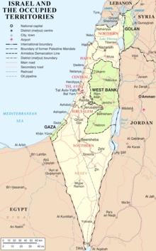
West Bank, including East Jerusalem Flag of Israel.svg  Israel
Flag of Jordan.svg  Jordan
19671988During the Six-Day War, Israel conquered these territories from Jordan. Jordan later renounced the claim on the territory, supporting instead its inclusion in a future Palestine.
Ligitan and Sipadan Flag of Malaysia 23px.svg  Malaysia
Flag of Indonesia.svg  Indonesia
19692002The 2002 International Court of Justice ruling awarded both islands to Malaysia, but left unsettled the maritime boundary immediately southwest and west of the islands between Malaysia and Indonesia.
Hawar Islands Flag of Qatar.svg  Qatar
Flag of Bahrain (1972-2002).svg  Bahrain
19712001Formerly disputed between Qatar and Bahrain, it was settled by the International Court of Justice (ICJ) in The Hague. In the June 2001 decision, Bahrain kept the Hawar Islands and Qit'at Jaradah but dropped claims to Janan Island and Zubarah on mainland Qatar, while Qatar retained significant maritime areas and their resources. The agreement has furthered the goal of definitively establishing the border with Saudi Arabia and Saudi-led mediation efforts continue.
Batek Island Flag of Indonesia.svg  Indonesia
Flag of East Timor.svg  East Timor
20022004Ceded by Timor-Leste to Indonesia in August 2004.
11,000 square miles (28,000 km2) of territory in Xinjiang [78] Flag of Pakistan.svg  Pakistan
(still claimed by:
Flag of the People's Republic of China.svg  People's Republic of China [note 1]
Flag of the Republic of China.svg  Republic of China [note 1] )
19471963Pakistan relinquished its claim to the People's Republic of China.
Aksai Chin [20] Flag of Pakistan.svg  Pakistan
(still claimed by:
Flag of India.svg  India
Flag of the People's Republic of China.svg  People's Republic of China [note 1]
Flag of the Republic of China.svg  Republic of China [note 1] )
19471963Pakistan relinquished its claim to the People's Republic of China; India did not.
Demchok sector Flag of Pakistan.svg  Pakistan
(still claimed by:
Flag of India.svg  India
Flag of the People's Republic of China.svg  People's Republic of China [note 1]
Flag of the Republic of China.svg  Republic of China [note 1] )
19471963Claimed as part of the princely state of Kashmir.
Chumar [78] Flag of Pakistan.svg  Pakistan
(still claimed by:
Flag of India.svg  India
Flag of the People's Republic of China.svg  People's Republic of China [note 1]
Flag of the Republic of China.svg  Republic of China [note 1] )
19471963Claimed as part of the princely state of Kashmir. Pakistan relinquished its claim to the People's Republic of China; India did not.
3,700 square miles (9,600 km2) of territory in Gilgit-Baltistan, and the Siachen Glacier [78] Flag of Pakistan.svg  Pakistan
Flag of the People's Republic of China.svg  People's Republic of China [note 1]
Flag of the Republic of China.svg  Republic of China [note 1] )
Flag of India.svg  India
19601963The People's Republic of China relinquished its claim to Pakistan. India and the Republic of China did not.
Saudi Arabia–Yemen border demarcation disputeFlag of Saudi Arabia.svg  Saudi Arabia
Flag of Yemen.svg  Yemen
19342000Settled by the Treaty of Jeddah (2000).
Limbang District Flag of Malaysia.svg  Malaysia
Flag of Brunei.svg  Brunei
19672010 Limbang District was part of Brunei until it was forced to cede it to the Raj of Sarawak in 1890. Since then Brunei is divided territorially into two. It was claimed by Brunei in 1967 in order to reconnect the country. It forms the main part of the Brunei–Malaysia border#Disputes. Malaysia claimed to settle the issue in 2009, however this was disputed by Brunei. Malaysia in 2010 ceded two hydrocarbon concession blocks to Brunei in exchange for Brunei dropping claims to Limbang. [20]
Hanish Islands Flag of Yemen.svg  Yemen
Flag of Eritrea.svg  Eritrea
19951999In December 1995, Eritrea entered into a dispute with Yemen over claims to the Hanish Islands and fishing rights in the Red Sea. This dispute was resolved in 1999 when the islands were awarded to Yemen through international arbitration, and the Eritreans complied with the verdict.
Shatt al-Arab Flag of Iran.svg  Iran
Flag of Iraq.svg  Iraq
19361988Settled by the 1975 Algiers Agreement. Reneged on by Iraq in 1980, but re-agreed to in 1988.
Makati–Taguig boundary dispute Taguig
Makati City.svg Makati
Flag of Pateros.svg Pateros
19832023Taguig claimed more than 7.29 square kilometres (2.81 sq mi) of land in Fort Bonifacio, an area formerly administered by Makati. On August 5, 2013, the Court of Appeals Sixth Division ruled that Makati had legal jurisdiction over the area, thus invalidating Taguig's claim. [160] Taguig did not abandon its claims and petitioned the Court of Appeals to have the decision revoked. [161] Pateros also claimed the area and filed a petition before the Taguig Regional Court Branch 271 in 2012 concerning its claim. Pateros reiterated its claims in 2013 following the decision of the Court of Appeals awarding Makati jurisdiction over the area. [162] [163] The Supreme Court finally ruled in favor of Taguig in 2023, [164] and the ruling began to be implemented in that year's elections.
Certain islands in the Naf River, St. Martin's Island Flag of Bangladesh.svg  Bangladesh
Flag of Myanmar.svg  Myanmar
19712019The dispute dates back to the independence of Bangladesh. The two countries agreed on Bangladeshi sovereignty over St. Martin's Island in 1974, but a maritime dispute continued. Marked by sporadic border violence, including the Tatmadaw shooting Bangladeshi fishermen, the maritime dispute was solved in 2012 by an ITLOS ruling. Then, in 2018, a diplomatic incident occurred when the Burmese government released an official map depicting St. Martin's Island as Burmese territory. [165] Myanmar subsequently acknowledged Bangladeshi sovereignty over St. Martin's Island and finally removed it from its official map by 2019. [166]
Assam-Arunachal Pradesh border Seal of Assam.svg Assam
Arunachal Pradesh
19512023The dispute between the two Indian states spanned 1,200 points [167] and contained 123 villages, dating as far back as a 1951 single-member commission land transfer recommendation when Arunachal Pradesh was the North-East Frontier Agency. In April 2023, both states signed a memorandum of understanding to jointly demarcate their border. By September 2023, 115 villages went to Arunachal Pradesh and 8 villages went to Assam. [168]
Kuwait-Saudi Arabia border, Qaruh, and Umm al Maradim Flag of Kuwait.svg  Kuwait
Flag of Saudi Arabia.svg  Saudi Arabia
Flag of Iraq.svg  Iraq
Flag of the United Kingdom.svg  United Kingdom
19132019The dispute dates as far back as when the United Kingdom and Ottoman Empire signed the Anglo-Ottoman Convention of 1913, defining the border in two phases: a formal boundary as well as a British "sphere of influence". This agreement was never ratified due to major complications: the Ottoman Empire had no de facto control over any of the area, because the Sheikhdom of Kuwait was effectively a British protectorate, Najd Sanjak was occupied by the Emirate of Nejd and Hasa, and the signatories proceeded to fight against each other in World War I, which ended in the dissolution of the Ottoman Empire. From 1919-1920, the Saudis attempted to annex Kuwait in the Kuwait-Najd War, which ended in the Uqair Protocol of 1922. The Protocol defined a "neutral zone" between the Sheikhdom of Kuwait and Sultanate of Nejd. The State of Kuwait inherited the United Kingdom's territorial claim when it gained independence in 1961. In 1965, a separation line was drawn halfway through the neutral zone; Qaruh and Umm al Maradim are north of the line. Kuwait interpreted as the de jure border but Saudi Arabia recognized it only as de facto, leaving the sovereignty of the northern half of the "neutral zone" in question. In 1990, Ba'athist Iraq invaded Kuwait; the Republic of Kuwait was declared and annexed into Iraq, causing the Gulf War. Kuwaiti and Coalition forces recaptured Qaruh and Umm al-Maradim in one of the first battles of the war, which ended in total Iraqi defeat and withdrawal of Iraq's territorial claim. Finally, in 2019, Kuwait and Saudi Arabia signed a memorandum of understanding in which Saudi Arabia recognized the separation line as a permanent international border. [169]
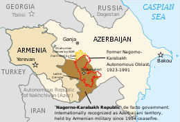
Nagorno-Karabakh and surrounding territories, parts of Goranboy, Khojavend, and Tartar districtsFlag of Azerbaijan.svg  Azerbaijan
Flag of Artsakh.svg  Artsakh
19882024Following the dissolution of the Soviet Union, internationally recognized as part of Azerbaijan [170] but controlled by the Republic of Artsakh, which was de facto supported by Armenia until its dissolution in 2024. Artsakh claimed a part of Goranboy district, which it lost during Operation Goranboy in 1993 during the First Nagorno-Karabakh War, as part of Shahumyan Province. Artsakh also claimed but did not control parts of Khojavend and Tartar districts as parts of Martuni and Martakert provinces, respectively. Azerbaijan captured the surrounding territories and the city of Shusha during the Second Nagorno-Karabakh War in 2020, then finally all of Nagorno-Karabakh proper during a 2023 offensive.

Europe

TerritoryFormer claimantsDispute startedDispute settledNotes
Village of Aibga and surrounding area [171] [172] Flag of the Republic of Abkhazia.svg  Republic of Abkhazia
Flag of Russia.svg  Russia
Flag of Georgia.svg  Georgia
20112011During the existence of the Soviet Union, the village of Aibga was divided into two; the southern part belonged to Georgia and the northern part to Russia. In March 2011 Russia laid claim to the southern area of Aibga. After the Abkhaz side proved that the southern part of Aibga belonged to the Georgian SSR, the claim on the village was dropped by Russia. [173]
Åland Flag of Finland.svg  Finland
Flag of Sweden.svg  Sweden
19171921Sweden and Finland argued over the control of the Åland Islands (located between Sweden and Finland). The Åland movement (Ålandsrörelsen) wanted Åland to reunite with its old mother country Sweden (Finland and Åland belonged to Sweden before 1809). The movement gathered signatures from over 7000 inhabitants of legal age at the Åland Islands in 1917 (that was about 96% of the population) - they all supported a union with Sweden. When Finland became independent (December 6, 1917) Sweden wanted a plebiscite about the future of the Åland Islands to solve the problem. Finland refused and argued that the Åland Islands had always been a natural part of Finland - even when Finland was under Swedish rule. Sweden appealed to the League of Nations referring to the right of the population to determine which country they should belong to. After studying the matter closely the League of Nations decided Finland should retain sovereignty over the province but that the Åland Islands should be made an autonomous territory. The Swedish Prime Minister said he didn't accept the verdict but he also said that Sweden was not going to use military force to get their claims. [174]
Baltic Sea Flag of Poland.svg  Poland
Flag of Denmark.svg  Denmark
19782018Poland has decided to cede to Denmark 80 percent of the disputed territory [175]
Bessarabia and Northern Bukovina Flag of the Soviet Union.svg  Soviet Union
Flag of Romania (1965-1989).svg  Socialist Republic of Romania
19401989On 13 November 1989, Nicolae Ceauşescu demanded the annulment of the Molotov–Ribbentrop pact, pursuant to which Bessarabia and Northern Bukovina were occupied by the Soviet Union, and the return of these territories to Romania. This demand was officially adopted as party policy by 14th Congress of the Communist Party of Romania, held later the same month. Ceauşescu was overthrown in the Romanian Revolution in December 1989 before the claim could be seriously pursued, and the post-revolutionary National Salvation Front abandoned it.
Bulgaria-Turkey riverine borderFlag of Bulgaria.svg  Bulgaria
Flag of Turkey.svg  Turkey
19901990The border at the Rezovo's mouth was the subject of a minor territorial dispute between Bulgaria and Turkey, which was settled in the 1990s. As a result of an agreement between the two countries of 6 May 1992 (ratified by Bulgaria in 1998), Bulgaria received a small land area of several square kilometres in the Rezovo Bay in return for water area in the continental shelf.
Graham Island Flag of the Kingdom of the Two Sicilies (1816).svg  Two Sicilies
19th Century Flag of Malta.svg Malta
Flag of France.svg  France
Flag of Spain (1785-1873, 1875-1931).svg  Spain
18311831A dispute between the Kingdom of the Two Sicilies, the British Crown Colony of Malta, the Kingdom of France and the Kingdom of Spain occurred after the volcanic island appeared in 1831. The British were the first to claim the island as part of Malta, and they were followed by the Two Sicilies and France, while Spain expressed their ambitions to control the island. The island disappeared by December 1831 and the dispute stopped. A Sicilian flag was lowered over the now submerged island in 2000 to show Italian claims to the area. It is no longer disputed by Britain, France, Spain or Malta.
Lampedusa Bandiera del Regno di Sicilia 4.svg  Kingdom of Sicily
19th Century Flag of Malta.svg Malta
18001814The island was controlled by British troops as a de facto part of the Malta Protectorate from 1800 onwards. After a British royal commission was sent there in 1812, the new Governor of Malta Sir Thomas Maitland withdrew British troops and the island was returned to Sicily.
Tenedos/Bozcaada Flag of Turkey.svg  Turkey
Flag of Greece (1822-1978).svg  Greece
19201923On 11 August 1920, following World War I, the Treaty of Sèvres with the defeated Ottoman Empire granted the island to Greece, who joined the war in Allies' side in May 1917. The new Turkish Government of Mustafa Kemal Atatürk, based in Ankara, which was not party to the treaty, overthrew the Ottoman government, which signed but did not ratify the treaty. After the Turkish War of Independence ended in Greek defeat in Anatolia, and the fall of David Lloyd George and his Middle Eastern policies after the Carlton Club meeting, the western powers agreed to the Treaty of Lausanne with the new Turkish Republic, in 1923. This treaty made Tenedos/Bozcaada and Imbros part of Turkey, and it guaranteed a special autonomous administrative status there to accommodate the Greeks.
Island of Ireland Flag of the United Kingdom.svg  United Kingdom
Flag of Ireland.svg  Revolutionary Irish Republic
19191922On 21 January 1919, the 69 Sinn Féin MPs elected in the 1918 United Kingdom general election to the British House of Commons refused to take their seats in the British Parliament and instead assembled in a separate parliament in Ireland, which proclaimed Irish independence under a revolutionary Irish Republic, leading to the Irish War of Independence. In 1920, following the collapse of the British administration, the revolutionary republic established control over 21 of Ireland's 32 counties, [176] with only urban areas and what would later become Northern Ireland remaining under British control; however, by the Anglo-Irish treaty of 1921, which ended the war of independence, the revolutionary republic was replaced by the Irish Free State—a semi-independent Dominion of the British Empire albeit separate from the United Kingdom itself—on 6 December 1922. A day later, Northern Ireland opted out of inclusion in the Irish Free State and returned to the UK, thus de facto effecting the partition of Ireland into two regions, established de jure by the British Parliament's Government of Ireland Act 1920 on 23 December 1920. On 1 July 1937, the Irish Free State adopted a new constitution, by which it declared itself a fully independent state simply called "Ireland"; this Constitution also declared a claim to Northern Ireland until 1998.
Northern Ireland Flag of the United Kingdom.svg  United Kingdom
Flag of Ireland.svg  Ireland
19371998Formerly disputed between Ireland and the United Kingdom since the Adoption of the Constitution of Ireland on 29 December 1937, it was settled by the Good Friday Agreement in 1998, when Ireland amended its constitution to withdraw its constitutional claim. Both countries acknowledged that the territory can join the rest of Ireland if separate referendums in both Northern Ireland and the Republic of Ireland approve of the former's cession.
Pytalovo (Abrene in Latvia)Flag of Russia.svg  Russia
Flag of Latvia.svg  Latvia
19912007Pytalovo was a village in the parish of Vyshgorogok, the westernmost part of the Ostrov uyezd, Governorate of Pskov that was ceded from RSFSR to Latvia under the Treaty of Riga (1920) along with parishes of Kachanovo and Tonkovo. In 1940 Latvian Republic was annexed by the Soviet Union and Latvian SSR was established, encompassing the above named territories until 1944 when they were transferred to the district of Ostrov, Pskov Oblast, RSFSR. [177] Since 1991 reestablished Republic of Latvia disputed Russian jurisdiction over the region until the border treaty with Russia was signed in 2007. [178]
Ivangorod/Jaanilinn and Pechorsky District/Petserimaa Flag of Russia.svg  Russia
Flag of Estonia.svg  Estonia
19912014In 1917, the Autonomous Governorate of Estonia was formed by merging the governorates of Estonia and (parts of) Livonia. In the same year, a referendum was held in the midst of the Russian Revolution, joining Narva (and Ivangorod) to the governorate, which were previously part of Saint Petersburg Governorate. [179] The south-eastern border was based on old provincial borders, which lay west of the present border. [180] Under the 1920 Treaty of Tartu, the border of the newly established Republic of Estonia was set eastwards after border talks, incorporating the later-formed Petseri County. Estonia was occupied and annexed by the USSR in 1940. In 1944, decrees of the USSR Presidium of the Supreme Soviet, set the northeastern border along Narva river, re-ceding Ivangorod to Leningrad Oblast and select volosts/parishes of Petserimaa to Pskov Oblast. The Estonian constitution still references the 1920 treaty as the border. Repeated attempts to resolve the border dispute have de jure failed, as no border treaty has been ratified. [181] The unratified agreement does, however, renounce Estonian claims to these lands, in addition to acknowledgements of the de facto situation by heads of state and government at various points. [182] [183]
Black Sea and Snake Island Flag of Ukraine.svg  Ukraine
Flag of Romania.svg  Romania
20042009In 2004 Romania filed a case to International Court of Justice claiming that Ukraine's Snake Island was an uninhabitable rock under UNCLOS standards and thus not eligible to carry influence over determination of the maritime boundary between the two states. During the Soviet times the island was a small naval station with a lighthouse. In 2007 the Ukrainian parliament approved an establishment of a small settlement there, Bile, as part of the Odesa Oblast. The maritime boundary issue was settled by the International Court of Justice in 2009, awarding Romania 80% of the disputed area.
Vilnius Region Flag of Lithuania.svg  Lithuania
Flag of Poland.svg  Poland
19201945During the Polish–Soviet War Polish armies entered the Vilnius Region which was at the time part of the Soviet Lithuanian–Belorussian Soviet Socialist Republic. In 1920, Polish General Lucjan Żeligowski led a coup and established the Republic of Central Lithuania which was annexed to the Second Polish Republic after the war as part of the historic Polish–Lithuanian Commonwealth and due to ethnic Poles in the region. Lithuania moved its capital to Kaunas while never giving up its claim to Vilnius. The Lithuanians found support in the Soviet Union for their cause signing the Soviet–Lithuanian Mutual Assistance Treaty in 1939. Following the Soviet invasion of Poland, the region came under Soviet control and became part of the Lithuanian SSR after World War II which was followed by a large number of ethnic Poles being deported two times. Following the fall of the Soviet Union and Act of the Re-Establishment of the State of Lithuania the Vilnius region became part of Lithuania again.
Passetto di Borgo in the vicinity of the Vatican City Flag of Italy.svg  Italy
Flag of the Vatican City - 2001 version.svg  Holy See
18701991 Pope John Paul II recognized the sovereignty of Italy over the Passetto on May 18, 1991. [184] [185]
Jan Mayen Flag of Norway.svg  Norway
Flag of Iceland.svg  Iceland
19791980Norway and Iceland argued over sovereignty of Jan Mayen from the period of 1979 to 1980. The island had been annexed by Norway in 1926, and was home of a Norwegian meteorological station. During a delegation to Iceland in April 1980, Icelandic foreign minister Ólafur Jóhannesson cited statements from the late 1920s to point out how Iceland never officially recognised Norway’s annexation of the island. He also indicated that, historically, the island had much closer ties to Iceland than it did to Norway. The Icelandic government never intended to seriously dispute the sovereignty of the island, but used these points in order to gain a bargaining position over the waters surrounding the island. On the 28th of May 1980, Iceland and Norway signed a treaty which gave Iceland most of what it wanted, including a recognition of the 200 nautical mile Exclusive economic zone around Iceland. [186]

Disputes over territorial waters

TerritoryClaimantsNotes
Part of the EEZ generated by the Natuna Islands Flag of the People's Republic of China.svg  People's Republic of China [note 1]
Flag of the Republic of China.svg  Republic of China [note 1]
Flag of Indonesia.svg  Indonesia
The People's Republic of China claims the water off the Natuna Islands that fall under the nine-dash line claim are traditional Chinese fishing grounds. The Republic of China on Taiwan also claims the area. [187]
Beaufort Sea Flag of Canada (Pantone).svg  Canada
Flag of the United States.svg  USA
Northwest Territories
Dixon Entrance
Northwest Passage and some other Arctic waters U.S. claims navigation rights
Strait of Juan de Fuca
Gulf of Venezuela and Los Monjes Archipelago surrounding watersFlag of Colombia.svg  Colombia
Flag of Venezuela.svg  Venezuela
Dispute regarding the undefined sea border between both countries. [188]
Aegean dispute Flag of Greece.svg  Greece
Flag of Turkey.svg  Turkey
Broad number of delimitation disputes about a.o. national airspace, territorial waters and exclusive economic zones.
Carlingford Lough and Lough Foyle boundary disputeFlag of Ireland.svg  Ireland
Flag of the United Kingdom.svg  United Kingdom
Lough Foyle divides County Donegal, Republic of Ireland, and County Londonderry, Northern Ireland. Carlingford Lough divides County Louth, Republic of Ireland, and County Down, Northern Ireland. [189] [190]
Dollart Bay Flag of Germany.svg  Germany
Flag of the Netherlands.svg  Netherlands
The exact course of the border through this bay is disputed, [191] yet the countries have agreed to disagree by signing a treaty in 1960. [192]
Lake Constance Flag of Germany.svg  Germany
Flag of Austria.svg  Austria
Flag of Switzerland (Pantone).svg  Switzerland
Switzerland holds the view that the border runs through the middle of the lake.
Austria is of the opinion that the contentious area belongs to all the states on its banks.
Germany holds an ambiguous opinion.
Gulf of Piran Flag of Slovenia.svg  Slovenia
Flag of Croatia.svg  Croatia
An agreement was signed (and ratified by Croatia's parliament on 20 November 2009) to pursue binding arbitration to both the land and maritime portions of this continuing dispute.
In 2015 collusion between the Slovenian judge on the arbitration panel and a representative from the Slovenian government was uncovered. The Croatian Sabor voted to withdraw from the arbitration, citing allegations of significant breaches of arbitration rules by Slovenia as the reason.
Despite this the arbitration tribunal continued its work, issuing a ruling in 2017. [193]

Notes

  1. 1 2 3 4 5 6 7 8 9 10 11 12 13 14 15 16 17 18 19 20 21 22 23 24 25 26 27 28 29 30 31 32 33 34 35 36 37 38 39 40 41 42 43 44 45 46 47 48 49 50 51 52 53 54 55 56 57 58 59 60 Since the end of the Chinese Civil War in 1949, the de facto territories of the Republic of China (ROC) are limited to the Taiwan Area. [71] [72] Meanwhile, the People's Republic of China (PRC) controls mainland China, Hong Kong and Macau. [71] Officially, both the ROC and the PRC claim de jure sovereignty over all of China (including Taiwan), and regard the other government as being in rebellion. [71] [73] [74] In Taiwan, the ROC's constitutional claim is supported by the Pan-Blue Coalition led by the Kuomintang, while the Pan-Green Coalition led by the Democratic Progressive Party favors Taiwanese independence and does not actively pursue the claim.
  2. 1 2 3 4 5 6 7 8 9 10 11 12 13 14 15 16 17 18 19 20 21 22 23 24 25 26 27 28 29 30 31 32 Relinquished by the People's Republic of China (PRC) but is still officially claimed by the Republic of China (ROC). Officially, both the PRC and the ROC claim de jure sovereignty over all of China (including Taiwan), and regard the other government as being in rebellion. [71] [73] [74] Therefore, the ROC does not recognize any territorial dispute settlement entered into by the PRC. [79]
  3. 1 2 The Democratic People's Republic of Korea (North Korea) and the Republic of Korea (South Korea) do not recognize each other.

See also

Related Research Articles

<i>The World Factbook</i> Reference resource produced by the Central Intelligence Agency

The World Factbook, also known as the CIA World Factbook, is a reference resource produced by the Central Intelligence Agency (CIA) with almanac-style information about the countries of the world. The official print version is available from the Government Publishing Office. The Factbook is available in the form of a website that is partially updated every week. It is also available for download for use off-line. It provides a two- to three-page summary of the demographics, geography, communications, government, economy, and military of 266 international entities, including U.S.-recognized countries, dependencies, and other areas in the world.

<span class="mw-page-title-main">Foreign relations of Guyana</span> Overview of the foreign relations of Guyana

After independence in 1966, Guyana sought an influential role in international affairs, particularly among Third World and non-aligned nations. It served twice on the UN Security Council. Former Vice President, Deputy Prime Minister, and Attorney General Mohamed Shahabuddeen served a 9-year term on the International Court of Justice (1987–96). In June 2023, Guyana was elected as a non-permanent member to the UN Security Council. The country will serve on the Council for a period of two years, beginning in January 2024.

<span class="mw-page-title-main">Exclusive economic zone</span> Adjacent sea zone in which a state has special rights

An exclusive economic zone (EEZ), as prescribed by the 1982 United Nations Convention on the Law of the Sea, is an area of the sea in which a sovereign state has exclusive rights regarding the exploration and use of marine resources, including energy production from water and wind. EEZ does not define the ownership of any maritime features within the EEZ.

<span class="mw-page-title-main">Scarborough Shoal</span> Disputed atoll in the South China Sea

Scarborough Shoal, also known as Bajo de Masinloc, Huangyan Island, Minzhu Jiao and Panatag Shoal, are two skerries (rocks) located between Macclesfield Bank to the west and Luzon to the east. Luzon is 220 kilometres (119 nmi) away and the nearest landmass. The atoll is a disputed territory claimed by the Republic of the Philippines through the 1734 Velarde map, while the People's Republic of China and the Republic of China (Taiwan) claim it through the disputed nine-dash line. The atoll's status is often discussed in conjunction with other territorial disputes in the South China Sea such as those involving the Spratly Islands, and the 2012 Scarborough Shoal standoff. It was administered by the Philippines as part of its Zambales province, until 2012, when a standoff was initiated by China through the use of warships against fishing boats, resulting in effective capture by the Chinese maritime forces.

<span class="mw-page-title-main">Territorial evolution of the United States</span>

The United States of America was formed after thirteen British colonies in North America declared independence from the British Empire on July 4, 1776. In the Lee Resolution, passed by the Second Continental Congress two days prior, the colonies resolved that they were free and independent states. The union was formalized in the Articles of Confederation, which came into force on March 1, 1781, after being ratified by all 13 states. Their independence was recognized by Great Britain in the Treaty of Paris of 1783, which concluded the American Revolutionary War. This effectively doubled the size of the colonies, now able to stretch west past the Proclamation Line to the Mississippi River. This land was organized into territories and then states, though there remained some conflict with the sea-to-sea grants claimed by some of the original colonies. In time, these grants were ceded to the federal government.

<span class="mw-page-title-main">Sino-Indian border dispute</span> Border dispute between China and India

The Sino–Indian border dispute is an ongoing territorial dispute over the sovereignty of two relatively large, and several smaller, separated pieces of territory between China and India. The first of the territories, Aksai Chin, is administered by China and claimed by India; it is mostly uninhabited high-altitude wasteland but with some significant pasture lands at the margins. It lies at the intersection of Kashmir, Tibet and Xinjiang, and is crossed by China's Xinjiang-Tibet Highway; the other disputed territory is south of the McMahon Line, in the area formerly known as the North-East Frontier Agency and now a state called Arunachal Pradesh. It is administered by India and claimed by China. The McMahon Line was signed between British India and Tibet to form part of the 1914 Simla Convention, but the latter was never ratified by China. China disowns the McMahon Line agreement, stating that Tibet was not independent when it signed the Simla Convention.

<span class="mw-page-title-main">Indonesia–Malaysia border</span> International border

The Indonesia–Malaysia border consists of a 1,881 km land border that divides the territory of Indonesia and Malaysia on the island of Borneo. It also includes maritime boundaries along the length of the Straits of Malacca, in the South China Sea and in the Celebes Sea.

<span class="mw-page-title-main">Bhutan–China relations</span> Bilateral relations

Bhutan-China relations refer to the international relationship between the Kingdom of Bhutan and the People's Republic of China. As of March 2024, Bhutan and China do not share an official diplomatic relationship with one another.

<span class="mw-page-title-main">Spratly Islands dispute</span> Territorial dispute between China and Southeast Asian countries.

The Spratly Islands dispute is an ongoing territorial dispute between Brunei, China, Malaysia, the Philippines, Taiwan, and Vietnam concerning "ownership" of the Spratly Islands, a group of islands and associated "maritime features" located in the South China Sea. The dispute is characterized by diplomatic stalemate and the employment of military pressure techniques in the advancement of national territorial claims. All except Brunei occupy some of the maritime features.

<span class="mw-page-title-main">Nine-dash line</span> Contested Chinese map of South China Sea

The nine-dash line, also referred to as the eleven-dash line by Taiwan, is a set of line segments on various maps that accompanied the claims of the People's Republic of China and the Republic of China in the South China Sea. The contested area includes the Paracel Islands, the Spratly Islands, the Pratas Island and the Vereker Banks, the Macclesfield Bank, and the Scarborough Shoal. Certain places have undergone land reclamation by the PRC, ROC, and Vietnam. The People's Daily of the PRC uses the term Duànxùxiàn (断续线) or Nánhǎi Duànxùxiàn, while the ROC government uses the term Shíyīduàn xiàn.

<span class="mw-page-title-main">Territorial disputes in the South China Sea</span> Disputes over ownership of islands in the South China Sea

Territorial disputes in the South China Sea involve conflicting island and maritime claims in the South China Sea by several sovereign states, namely the People's Republic of China (PRC), Taiwan, Brunei, Malaysia, the Philippines, Vietnam and Indonesia. The disputes involve the islands, reefs, banks, and other features of the region, including the Spratly Islands, Paracel Islands, Scarborough Shoal, and various boundaries in the Gulf of Tonkin. The waters near the Indonesian Natuna Islands, which some regard as geographically part of the South China Sea, are disputed as well.

<span class="mw-page-title-main">Bhutan–China border</span> International border

The Bhutan–China border is the international boundary between Bhutan and Tibet, China, running for 477 km (296 mi) through the Himalayas between the two tripoints with India.

The borders of Indonesia include land and maritime borders with Malaysia, Papua New Guinea, and East Timor, as well as shared maritime boundaries with Australia, India, Palau, Philippines, Singapore, Thailand, and Vietnam.

<span class="mw-page-title-main">Chinese irredentism</span> Irredentist claims to territories of the former Chinese Empire

Chinese irredentism involves irredentist claims to the territories of former Chinese dynasties made by the Republic of China (ROC) and subsequently the People's Republic of China (PRC).

<span class="mw-page-title-main">Territorial disputes of the People's Republic of China</span>

This article is about territorial disputes of the People's Republic of China (PRC). A territorial dispute is a disagreement over the possession or control of land between two or more political entities. Many of these territorial disputes are almost identical to those that the Republic of China (ROC) based in Taipei, also known as Taiwan, has with other countries. Therefore, many of the subsequent resolved disputes made by the PRC after 1949 with other governments may not be recognized by the ROC.

This is a timeline of country and capital changes around the world since 2000. It includes dates of declarations of independence, changes in country name, changes of capital city or name, and changes in territory such as the annexation, cession, concession, occupation, or secession of land. Territorial conquests as a result of war are included on the timeline at the conclusion of military campaigns. However, those changes in the course of specific battles and day-to-day operations are generally not included in this list. Changes in airspace and maritime territory are included only when they are subject to a dispute.

References

  1. 1 2 3 4 5 6 7 8 9 10 11 12 13 14 "Field Listing - Disputes - international". The World Factbook . Archived from the original on 16 October 2020.
  2. "Breaking News, World News & Multimedia" . Retrieved 30 June 2017.
  3. "Comunicados y notas de prensa de la OID" (PDF). Archived from the original (PDF) on 27 September 2007.
  4. 1 2 Maasho, Aaron (16 June 2017). Dalgleish, James (ed.). "Djibouti, Eritrea in territorial dispute after Qatar peacekeepers leave". Reuters.
  5. Suckling, Chris. "Eritrea's alleged seizure of disputed Djiboutian territory increases likelihood of miscalculation leading to military escalation". Jane's Information Group. Archived from the original on 25 June 2017. Retrieved 27 June 2017. Djibouti's foreign minister, Mahamoud Ali Youssouf, alleged in a televised address on 16 June that Eritrean forces had occupied the disputed Dumaira Mountains, immediately after Qatar withdrew a 500-strong contingent of peacekeepers without notification on 14 June.
  6. "Why are Egypt and Sudan in a dispute over the Hala'ib Triangle?(Quizzical)(Brief Article)". Archived from the original on 13 November 2007.
  7. Brownlie, Ian (1979). African Boundaries: A Legal and Diplomatic Encyclopedia. Institute for International Affairs, Hurst and Co. pp. 867–884, 917–921.
  8. Collins, Robert O. (2004). The Ilemi Triangle in: Annales d'Éthiopie. Volume 20, année 2004. pp. 5–12. doi:10.3406/ethio.2004.1065 . Retrieved 17 June 2011.
  9. The National Geographic Society in recent works has included an Ethiopian claim, later removed due to lack of sources. The World Factbook confirms that Ethiopia does not claim the territory
  10. "ESWATINI: Land claim falls on deaf SA ears". IRIN. 16 June 2003. Retrieved 7 March 2012.
  11. 1 2 "Différend frontier Burkina-Bénin: Kourou/Koalou déclarée zone (...) - leFaso.net, l'actualité au Burkina Faso". lefaso.net (in French). Retrieved 12 October 2017.
  12. "CIA World Factbook – Benin" . Retrieved 12 October 2017.
  13. "UNHCR Newsletter – January–August 2015". p. 5. Retrieved 12 October 2017.
  14. "Guinea, Cote d'Ivoire Border Dispute Reportedly Resurfaces". Guinee News. Archived from the original on 8 March 2014.
  15. "Côte d'Ivoire : un civil tué par des militaires guinéens à Kpéaba dans l'ouest du pays, la Guinée dément – JeuneAfrique.com". JeuneAfrique.com (in French). 23 December 2016. Retrieved 12 October 2017.
  16. "Côte d'Ivoire/Guinée: un ancien litige frontalier ressurgit à Kpéaba - RFI". RFI Afrique (in French). Retrieved 12 October 2017.
  17. Leonardi, Cherry (13 July 2020). "Patchwork States: The Localization of State Territoriality on the South Sudan–Uganda Border, 1914–2014*". Past & Present. 248 (1): 209–258. doi: 10.1093/pastj/gtz052 . ISSN   0031-2746.
  18. "South Sudan – Uganda Relations". ACCORD. Retrieved 2 June 2021.
  19. Tshiamala, Stanis Bujakera (27 August 2020). "Zambia & DRC's disputed territory in Tanganyika since colonial era". The Africa Report.com. Retrieved 2 June 2021.
  20. 1 2 3 4 5 "Field Listing :: Disputes - international — the World Factbook - Central Intelligence Agency". www.cia.gov. Archived from the original on 16 October 2020. Retrieved 30 June 2022.
  21. Compte rendu du déplacement d'une délégation du groupe interparlementaire France-Afrique centrale au Gabon, en Guinée équatoriale et à Sao Tomé-et-Principe , parliamentary report of the Senate of France, 2003.
  22. "UN mediates dispute over Corisco Bay islands". IRIN. 23 January 2004. Retrieved 12 October 2017.
  23. "Disputes – international - The World Factbook". www.cia.gov. Retrieved 3 June 2021.
  24. "Cameroon", The World Factbook, Central Intelligence Agency, 14 November 2023, retrieved 17 November 2023
  25. "Tension increases in ongoing land dispute". The New Humanitarian. 31 January 2006. Retrieved 3 June 2021.
  26. Gitta, Alex; Lubega, Emmanuel; Natalis, Veronica (27 December 2018). "Contested waters: Conflict on Africa's Great Lakes | DW | 27.08.2018". Deutsche Welle. Retrieved 3 June 2021.
  27. Muntschick, Johannes (9 October 2017). The Southern African Development Community (SADC) and the European Union (EU): Regionalism and External Influence. Springer. ISBN   9783319453309.
  28. Jacobs, Franks (23 July 2010). "396 - "You take it - No, you take it": the Bir Tawil Trapezoid". Big Think. Retrieved 3 June 2021.
  29. "Libya", The World Factbook, Central Intelligence Agency, 22 March 2023, retrieved 29 March 2023
  30. "Country Profile: Algeria". Library of Congress, Washington, D.C. 20540 USA. Retrieved 29 March 2023.
  31. "Algeria–Libya Land Boundary". Sovereign Limits. Retrieved 29 March 2023.
  32. International Court of Justice (2012). "Territorial and maritime dispute (Nicaragua vs Colombia)" (PDF). Retrieved 27 November 2012.
  33. "Honduras 1982 (rev. 2013) Constitution - Constitute". www.constituteproject.org. Retrieved 18 December 2023.
  34. "Navassa Island: The U.S.'s 160-year Forgotten Tragedy | History News Network". historynewsnetwork.org. 5 May 2019. Retrieved 3 August 2021.
  35. "Guatemala's Territorial, Insular and Maritime Claim (Guatemala/Belize)". International Court of Justice. Retrieved 2 December 2023.
  36. Ismail, Safira. "مزرعة دير العشاير.. أرض خصبة ومياه نظيفة وموسم خضراوات واعد". Syrian Arab News Agency (in Arabic). Retrieved 13 May 2024.
  37. Korbel, Josef (1966), Danger in Kashmir, Princeton University Press
  38. Schofield, Victoria (2003) [First published in 2000], Kashmir in Conflict, London and New York: I. B. Taurus & Co, ISBN   978-1860648984
  39. Bose, Sumantra (2003), Kashmir: Roots of Conflict, Paths to Peace, Harvard University Press, ISBN   978-0-674-01173-1
  40. Varshney, Ashutosh (1992), "Three Compromised Nationalisms: Why Kashmir has been a Problem" (PDF), in Raju G. C. Thomas (ed.), Perspectives on Kashmir: the roots of conflict in South Asia, Westview Press, pp. 191–234, ISBN   978-0-8133-8343-9
  41. Iwanek, Krzysztof (10 August 2020). "Why Did Pakistan Lay Claim to the Indian Territory of Junagadh?". The Diplomat. Retrieved 21 October 2022.
  42. "Pakistan Political Map" (PDF). surveyofpakistan.gov.pk. 2020. Retrieved 8 April 2024.
  43. "Kyrgyz In Exclave In Uzbekistan Want To Relocate To Kyrgyzstan". EurasiaNet. 12 May 2011. Archived from the original on 19 March 2014. Retrieved 15 March 2014.
  44. Azizov, Demir (18 February 2014). "Uzbekistan, Kyrgyzstan intensify work on delimitation and demarcation of state border". Archived from the original on 19 March 2014. Retrieved 15 March 2014.
  45. Борис ГОЛОВАНОВ (22 February 2002). "Продолжаются споры по линии прохождения узбеко-кыргызской границы. Неделимы Сох, Барак и Гавасай". Вечерний Бишкек. Archived from the original on 19 March 2014. Retrieved 15 February 2014.
  46. "Kyrgyzstan, Uzbekistan Agree To Work On Land Swap Near Border". RadioFreeEurope/RadioLiberty. Archived from the original on 15 March 2019. Retrieved 17 January 2019.
  47. MASALIEVA, Jazgul (3 February 2022). "Residents of Kyrgyz Barak exclave ask for meeting with Kamchybek Tashiev -". 24.kg. Retrieved 4 September 2022.
  48. "Enclaves III: The Fergana Valley". Archived from the original on 17 October 2013.
  49. "What drove the worst Kyrgyz-Tajik conflict in years?". The Third Pole. 28 May 2021. Retrieved 4 September 2022.
  50. "Syria's "Lost Province": The Hatay Question Returns".
  51. Territorial disputes of India and Nepal
  52. "北方領土問題の経緯(領土問題の発生まで)". Ministry of Foreign Affairs of Japan (in Japanese). Retrieved 2 October 2022.
  53. "衆議院議員鈴木宗男君提出南樺太、千島列島の国際法的地位などに関する質問に対する答弁書". 衆議院 (The House of Representatives, Japan). 4 November 2005.
  54. "樺太略史". 全国樺太連盟(All Japan Federation of Karafuto).
  55. Проблема острова Ноктундо в средствах массовой информации Южной Кореи [The problem of the Noktundo island in the media in South Korea] (in Russian). ru.apircenter.org. Archived from the original on 10 September 2013. Retrieved 3 November 2023.
  56. Westcott, Ben; Seo, Yoonjung (2019). "South Korea fires warning shots at Russian military aircraft". 10 News San Diego. Retrieved 24 November 2023.
  57. Lanko, D.A. (202). "Russian and Japanese approaches to the Korean Peninsula: A comparison from a societal viewpoint*" (PDF). Vestnik of Saint Petersburg University. International Relations. 13 (2): 243. Retrieved 24 November 2023.
  58. Pedra Branca case, operative clause; Sovereignty over Pedra Branca/Pulau Batu Puteh, Middle Rocks and South Ledge (Malaysia/Singapore), International Court of Justice, 23 May 2008, archived from the original on 27 May 2008, retrieved 25 October 2012. See also ICJ awards Pedra Branca's sovereignty to Singapore, Channel NewsAsia, 23 May 2008, archived from the original on 25 May 2008, retrieved 23 May 2008; "Court awards islet to Singapore", BBC News, 23 May 2008
  59. Dara, Mech. "Hun Sen set to visit Laos, discuss border issues". www.phnompenhpost.com. Retrieved 15 January 2022.
  60. "OP MEGHDOOT". Indian Air Force. Retrieved 17 September 2020.
  61. "КАСПИЙСКИЙ САММИТ НЕ СОСТОЯЛСЯ" . Retrieved 5 October 2014.
  62. "Uzbekistan, Kyrgyzstan Deploy Troops In Dispute Over Border Mountain". RadioFreeEurope/RadioLiberty. Retrieved 24 October 2014.
  63. "Uzbek side withdrew a police post from Ungar-Too". Kabar. Retrieved 24 October 2014.
  64. "Putin Signals Readiness for Peace Talks if Kyiv Cedes Occupied Regions". The Moscow Times. 5 January 2023.
  65. Maria Raquel Freire, "Ukraine and the Restructuring of East-West Relations" in The Russian Challenge to the European Security Environment (ed. Roger E. Kanet), p. 201.
  66. "Backing Ukraine's territorial integrity, UN Assembly declares Crimea referendum invalid". United Nations News. 27 March 2014.
  67. 1 2 "Russian-held parts of Ukraine's Mykolaiv region to be incorporated in Russian-held Kherson". Reuters. 21 September 2022. Retrieved 21 September 2022.
  68. Michael Day (28 June 2015). "Mont Blanc controversy: French suffer a fit of pique as Italy's Prime Minister 'reclaims' Europe's highest mountain". Independent.
  69. "Who owns Rockall? A history of disputes over a tiny Atlantic island". The Irish Times. 8 June 2019. Retrieved 7 February 2021.
  70. "Treaty on the delimitation of the maritime boundary between Tokelau and the United States of America (with map). Signed at Atafu on 2 December 1980. Authentic texts: English and Tokelauan. Registered by the United States on 25 July 1991" (PDF) (in English and Tokelau). 25 July 1991. Retrieved 28 August 2011.[ dead link ]
  71. 1 2 3 4 Sarmento, Clara (2009). Eastwards / Westwards: Which Direction for Gender Studies in the 21st Century?. Cambridge Scholars. p. 127. ISBN   9781443808682.
  72. Henckaerts, Jean-Marie (1996). The International Status of Taiwan in the New World Order: Legal And Political Considerations. Martinus Nijhoff Publishers. p. 117. ISBN   9789041109293.
  73. 1 2 Hudson, Christopher (2014). The China Handbook. Routledge. p. 59. ISBN   9781134269662.
  74. 1 2 Rigger, Shelley (2002). Politics in Taiwan: Voting for Reform. Routledge. p. 60. ISBN   9781134692972.
  75. "The South China Sea Island China Gave Away". The Diplomat . Retrieved 11 October 2022.
  76. 1 2 Shen, Zhihua; Xia, Yafeng (2013). "Contested Border: A Historical Investigation into the Sino-Korean Border Issue, 1950-1964". Asian Perspective. 37 (1): 1–30. doi:10.1353/apr.2013.0002. JSTOR   42704816. S2CID   153826874.
  77. "China is Building Entire Villages in Another Country's Territory". 7 May 2021.
  78. 1 2 3 4 "Facing the truth". 19 October 2006.
  79. "第一篇 總論 第二章 土地 第二節 大陸地區". China Yearbook. Government Information Office. 2005. Archived from the original on 29 March 2012.
  80. "Kyrgyz Report: August 26, 1999". Radio Free Europe/Radio Liberty. 11 November 2008. Retrieved 11 October 2022.
  81. Additional Articles of the Constitution of the Republic of China , Article 9, Section 2
  82. Constitution of the People's Republic of China , Preamble
  83. "China and Burma: Not Only Pauk-Phaw". 5 June 2017.
  84. Article 4 of the Act of Ensign of the Armed Forces first decreed on January 3, 1986
  85. "Tajikistan cedes land to China". BBC News. 13 January 2011.
  86. "What does disputed Paracel island look like?". BBC News. 17 February 2016. Retrieved 17 September 2020.
  87. "Underwater Reef Named 'Parangcho'".
  88. "Archived copy" (PDF). www.law.fsu.edu. Archived from the original (PDF) on 3 May 2012. Retrieved 30 June 2022.{{cite web}}: CS1 maint: archived copy as title (link)
  89. "Beijing now bullies Bhutan".
  90. "Nation protests Japan's Diaoyutai move". Taipei Times. 23 June 2020. Retrieved 15 September 2020.
  91. 1 2 中华人民共和国和阿富汗王国边界条约  [Afghanistan-China Border Agreement] (in Chinese). 22 November 1963 via Wikisource.
  92. Office of the Geographer (1 May 1969). "International Boundary Study - Afghanistan – China Boundary" (PDF). Bureau of Intelligence and Research. Archived from the original (PDF) on 3 January 2015. Retrieved 3 February 2017. The Afghanistan–China boundary agreement, signed on November 22, 1963, was the fifth of these boundaries treaties initiated by the Chinese communists.
  93. 全国人民代表大会常务委员会关于签订中华人民共和国和阿富汗王国边界条约的决议 (in Simplified Chinese). National People's Congress. Archived from the original on 17 October 2013. Retrieved 12 January 2020.
  94. Even official Chinese maps award these islands to North Korea, such as the provincial map on p. 41 in the 2005 Chinese atlas "Zhonghua Renmin Gongheguo Jiaotong Dituji" ISBN   7-80104-652-8, (http://www.starmap.com.cn)
  95. "G1 – Ação no STF acirra disputa entre Ceará e Piauí por área de divisa – notícias em Ceará". Ceará. 22 October 2011. Retrieved 5 October 2014.
  96. "Fernando de Noronha em meio a uma queda de braço". Folha de Pernambuco. Archived from the original on 21 August 2017. Retrieved 31 July 2017.
  97. "Antioquia pide respetar reglas en proceso de deslinde de Belén de Bajirá". Archived from the original on 6 October 2014. Retrieved 5 October 2014.
  98. "At least 100 killed in border clashes between Ethiopia's Somali and Afar regions - official". Reuters. 7 April 2021. Retrieved 9 April 2022.
  99. "Ethiopia: Afar-Issa land dispute, Flash Update (As of 27 January 2021) - Ethiopia". ReliefWeb. 30 January 2021. Retrieved 9 April 2022.
  100. St, Addis; ard (2 November 2020). "Clarification: Gadamaytu, Undufo and Adaytu are inside Afar, the regional state says in a letter". Addis Standard. Retrieved 9 April 2022.
  101. "Djibouti: Officials likely to maintain heightened security in Djibouti city through mid-August following Aug. 1 ethnic clashes /update 2 | Crisis24". 9 April 2022. Archived from the original on 9 April 2022. Retrieved 9 April 2022.
  102. 1 2 3 4 "Odisha's Border Disputes".
  103. Khapre, Shubhangi (30 January 2021). "Explained: The Maharashtra-Karnataka border dispute – the past and the present". The Indian Express .
  104. "Explained: Assam vs Nagaland, a border dispute of five decades". The Indian Express. 22 August 2014. Retrieved 12 June 2022.
  105. "Assam, Meghalaya Identify Six Areas of Dispute in 2nd Border Meet". 10 January 2022.
  106. "Explained: Assam-Mizoram border dispute, and its roots in two notifications dating to 1875 and 1933". The Indian Express. 3 August 2021. Retrieved 12 June 2022.
  107. "Village on Tripura-Mizoram border caught in another jurisdiction row, this time over a temple". ThePrint. 18 October 2020. Retrieved 12 June 2022.
  108. Tomczyk, Krzysztof (4 March 2010). "Tychy kontra Bieruń. Jak Kargul i Pawlak, ale z Fiatem w tle". Moje Miasto Silesia (in Polish). Media Regionalne. Retrieved 18 September 2014.
  109. Dewan, Shaila (22 February 2008). "Georgia Claims a Sliver of the Tennessee River". The New York Times.
  110. Barnard, Jeff (19 May 1985). "California-Oregon Dispute : Border Fight Has Townfolk on Edge". Los Angeles Times. Preliminary studies indicate that, as the result of an 1870 surveying error, Oregon has about 31,000 acres of California, while California has about 20,000 acres of Oregon.
  111. Turner, Wallace (24 March 1985). "SEA RICHES SPUR FEUD ON BORDER". New York Times.
  112. Sims, Hank (14 June 2013). "Will the North Coast Marine Protected Areas Spark a War With Oregon?". Lost Coast Outpost.
  113. California Department of Fish and Wildlife (1 March 2016). Map: Pyramid Point State Marine Conservation Area (PDF) (Map). California Department of Fish and Wildlife. Available from: http://nrm.dfg.ca.gov/FileHandler.ashx?DocumentID=117182
  114. Daniel Gertson. "Border War Brewing?". Archived from the original on 18 April 2018. Retrieved 17 April 2018.
  115. "Court Ruling Favors Ghana in Ocean Border Dispute With Ivory Coast". Voice of America. 23 September 2017. Retrieved 17 April 2024.
  116. "Ghana wins three-year maritime boundary dispute case against Ivory Coast". Africanews. 23 September 2017. Retrieved 17 April 2024.
  117. "International Court settles West African land dispute". Chicago Sun-Times. 1986. Archived from the original on 28 March 2015. Retrieved 9 October 2014.
  118. 1 2 ABBINK, J (1 October 1998). "Briefing: The Eritrean-Ethiopian Border Dispute". African Affairs. 97 (389): 551–565. doi:10.1093/oxfordjournals.afraf.a007970. hdl: 1887/9481 .
  119. 1 2 "Eritrea accepts 'virtual' border with Ethiopia". ABC News. 16 January 2008. Retrieved 5 May 2016.
  120. "International Court rules that main disputed island belongs to Niger not Benin". The Guardian. 8 May 2015. Retrieved 27 July 2016.
  121. "Congo Acknowledges Disputed Border Area Is In Angola Origin". Embassy Kinshasa cable. 16 March 2007. Archived from the original on 27 June 2012. Retrieved 19 July 2012.
  122. "Angola, DR Congo end border row". BBC. 31 July 2007. Retrieved 19 July 2012.
  123. "Kenya, Uganda to demarcate entire border". The East African. 6 July 2020. Retrieved 3 June 2021.
  124. "New Vision Online : Ugandan surveyors return to Migingo". Newvision.co.ug. 3 August 2009. Archived from the original on 5 June 2011. Retrieved 24 September 2011.
  125. "International Court rules that main disputed island belongs to Niger not Benin". IRIN. Dakar. 12 July 2005. Retrieved 27 July 2016.
  126. "Cases: Kasikili/Sedudu Island (Botswana/Namibia)". Archived from the original on 5 June 2011. Retrieved 30 June 2017.
  127. Touval, S. (1967), "The Organization of African Unity and African borders", International Organization, 21 (1): 102–127, doi:10.1017/s0020818300013151, JSTOR   2705705, S2CID   154805054 . Link requires subscription to Jstor.
  128. Bidwell, Robin (1998). Dictionary Of Modern Arab History. South Glamorgan: Kegan Paul International. ISBN   978-1138967670.
  129. Gleijeses, Piero (2002). Conflicting Missions: Havana, Washington and Africa, 1959–1976. Chapel Hill, NC: University of North Carolina Press. ISBN   978-0-807-82647-8.
  130. "Sierra Leone government takes media to disputed border with Guinea". News Kenya. Archived from the original on 5 March 2014.
  131. Beatriz Garcia, The Amazon from an International Law Perspective (Cambridge University Press, 2011) pp. 56-57
  132. Berton, Pierre (1988). The Arctic Grail: the Quest for the North West Passage and the North Pole, 1818–1909. Viking. p. 629. ISBN   978-0-670-82491-5.
  133. Fallo de 2012 de la Corte Internacional de Justicia. "Territorial and maritime dispute (Nicaragua vs Colombia)" (PDF). Retrieved 23 November 2012.{{cite web}}: CS1 maint: numeric names: authors list (link)
  134. Charney, Jonathan; American Society of International Law (2004). International Maritime Boundaries, Vol. 2–3. Boston, United States: Martinus Nijhoff Publishers. p. 2616. ISBN   978-90-411-0345-1. p2179-2192.
  135. "Maritime Dispute (Peru v. Chile)" (PDF). Archived from the original (PDF) on 2 February 2014. Retrieved 30 January 2014.
  136. "Grænlandsdraumurinn: Hugmyndir um tilkall Íslendinga til Grænlands á 20. öld" (PDF). Skemman. May 2019.
  137. "Legal Status of Eastern Greenland, Denmark v. Norway, Judgment, 5 September 1933, Permanent Court of International Justice (PCIJ)". Worldcourts.com. Archived from the original on 12 November 2020. Retrieved 11 November 2015.
  138. "Costa Rica & Nicaragua Settle Border Dispute in Court". Political Geography Now. 3 February 2018. Archived from the original on 5 February 2018. Retrieved 4 February 2018.
  139. Chase, Steven (10 June 2022). "Canada and Denmark reach settlement over disputed Arctic island, sources say". The Globe and Mail. Retrieved 11 June 2022.
  140. "Nederland en Frankrijk ruziën over grens Sint Maarten" (in Dutch). 12 November 2016. Retrieved 10 April 2020.
  141. "The border at Oyster Pond, the reason behind another conflict". 2 November 2016. Retrieved 10 April 2020.
  142. "Negotiations on Oyster Pond border to commence late 2019". 15 August 2019. Archived from the original on 24 February 2021. Retrieved 10 April 2020.
  143. "Frankrijk belemmert herbouw Oyster Pond" (in Dutch). 15 September 2019. Retrieved 10 April 2020.
  144. Bénis, Olivier (27 May 2023). "La France a une nouvelle frontière avec les Pays-Bas (dans les Antilles)". France Inter (in French).
  145. Barr, Susan (1987). Norway's Polar Territories. Oslo: Aschehoug. p. 63. ISBN   978-82-03-15689-2.
  146. "Kachchatheevu was not ceded to Sri Lanka, Centre tells court". The Hindu. 31 August 2013. ISSN   0971-751X . Retrieved 26 September 2021.
  147. Correspondent, Legal (22 August 2018). "HC wants to know status of case filed by Jayalalithaa to retrieve Katchatheevu". The Hindu. ISSN   0971-751X . Retrieved 31 May 2021.
  148. "Centre making sincere efforts to retrieve Katchatheevu: V.K. Singh". The Hindu. 8 February 2021. ISSN   0971-751X . Retrieved 16 April 2022.
  149. McGarr, Paul M., ed. (2013), "Triumph and tragedy:: the Rann of Kutch and the 1965 Indo-Pakistani War", The Cold War in South Asia: Britain, the United States and the Indian Subcontinent, 1945–1965, Cambridge: Cambridge University Press, pp. 301–344, doi:10.1017/CBO9781139022071.013, ISBN   978-1-107-00815-1 , retrieved 14 May 2022
  150. "Bay of Bengal Maritime Boundary Arbitration between Bangladesh and India". pca-cpa.org. Retrieved 12 June 2022.
  151. India (2 December 2014). "Everything you need to know: Land swap in offing with Bangladesh to end disputes". The Indian Express. Retrieved 29 May 2015.
  152. "India, Bangladesh inspect disputed land in Tripura". The Hindu. 17 November 2016. ISSN   0971-751X . Retrieved 12 June 2022.
  153. "Protocol to the Agreement Between the Government of the Republic of India and the Government of the People's Republic of Bangladesh Concerning the Demarcation of the Land Boundary Between India and Bangladesh and Related Matters" (PDF). South Asia Terrorism Portal.
  154. "Strip maps covering 98% of Indo-Nepal boundary jointly finalised by two countries: Govt". Business Standard India. Press Trust of India. 26 June 2019.
  155. Wade, Matt (25 March 2010). "Rising sea level settles border dispute". The Sydney Morning Herald. Retrieved 4 April 2010.
  156. "Bay of Bengal island 'disappears'". BBC News. 24 March 2010.
  157. A. G. Noorani. "Of Indo-Bangladesh distrust". Archived from the original on 8 September 2001.{{cite web}}: CS1 maint: unfit URL (link)
  158. George, Nirmala (24 March 2010). "Disputed isle in Bay of Bengal vanishes".
  159. Hanns Jürgen Buchholz. Law of the Sea Zones in the Pacific Ocean. Retrieved 2015-10-09. p.41
  160. "CA rules Makati City, not Taguig, has jurisdiction over Fort Bonifacio". 6 August 2013. Retrieved 5 October 2014.
  161. "Taguig to appeal CA decision on Fort Boni dispute". GMA News Online. 6 August 2013. Retrieved 5 October 2014.
  162. "Pateros: Fort Bonifacio is ours". ABS-CBN News. 7 August 2013. Retrieved 22 October 2014.
  163. "Pateros joins the fray: 'Fort Bonifacio is ours'". 7 August 2013. Retrieved 5 October 2014.
  164. Cruz, James (29 June 2023). "Supreme Court denies Makati's motion to file 2nd appeal on territory dispute vs Taguig". RAPPLER. Retrieved 4 November 2023.
  165. "Myanmar's Claim to St. Martin's Island Irks Bangladesh".
  166. "Country Map Administrative" (PDF). Myanmar Information Management Unit. 5 September 2019. Retrieved 18 November 2023.
  167. "Assam-Arunachal's boundary dispute". 13 August 2021. Retrieved 12 June 2022.
  168. "MoU on Assam-Arunachal border issue implemented in right earnest: Khandu". The Assam Tribune. 6 September 2023. Retrieved 1 December 2023.
  169. Al-Saif, Bader (31 March 2021). "Along the Kuwaiti-Saudi Border, Stability Is Built on Flexibility". Malcolm H. Kerr Carnegie Middle East Center. Retrieved 1 December 2023.
  170. "General Assembly adopts resolution reaffirming territorial integrity of Azerbaijan, demanding withdrawal of all Armenian forces". United Nations. 14 March 2008. Retrieved 23 December 2016.
  171. "Moscow, Sokhumi Dispute Village in 'Border Talks'". Civil.ge. 2 April 2011. Archived from the original on 21 April 2018.
  172. Troiano, Luca (23 May 2011). "Russia e Abkhazia litigano per i confini". AgoraVox Italia (in Italian).
  173. "Georgian State Border – Past and Present" (PDF). Center for Social Sciences. August 2012. Archived from the original (PDF) on 23 August 2014. Retrieved 24 August 2014.
  174. "Disputes in the League of Nations in the 1920's". MacGregor is History. Archived from the original on 16 June 2012.
  175. "Poland and Denmark sign agreement on maritime boundary in the Baltic Sea". 28 November 2018.
  176. M.E. Collins, Ireland, p. 252.
  177. "Указ Президиума ВС СССР от 23.08.1944 Об образовании Псковской области в составе РСФСР (Decree of the Supreme Council of USSR on establishing the Pskov Oblast within the RSFSR)". www.bestpravo.com. Archived from the original on 29 December 2016. Retrieved 18 December 2018.
  178. "The Republic of Latvia and the Russian Federation Treaty On the State Border of Latvia and Russia". www.mfa.gov.lv. 4 April 2007.
  179. Davõdov, Ilja (January 2008). "Vladimir Uljanovi (Lenini) allkirjaga dokument 16. novembrist 1917 Narva Linnavalitsuse arhiivifondis" (PDF). Retrieved 2 February 2024.
  180. Eestimaa kubermangu administratiivse juhtimise ja kohaliku omavalitsuse ajutise korra kohta. 12 April 1917
  181. "Venemaa kinnitas huvi piirilepingu ratifitseerimiseks". ERR Uudised. 9 September 2022. Retrieved 1 February 2024.
  182. Sildam, Toomas (9 May 2019). "Tarand vanas intervjuus Tartu rahu piirist: romantikaga on keeruline elada". ERR Uudised. Retrieved 1 February 2024.
  183. "Ilves: peame leppima tõsiasjaga, et Tartu rahu riigipiiri osas sajaprotsendiliselt ei kehti". Delfi. 11 February 2014. Retrieved 1 February 2024.
  184. "ABC (Madrid) - 06/08/1991, p. 51 - ABC.es Hemeroteca". hemeroteca.abc.es. Retrieved 30 June 2017.
  185. "Catholic Herald". CatholicHerald.co.uk. Retrieved 5 October 2014.
  186. "The Jan Mayen dispute between Iceland and Norway, 1979-1981". Guðni Th. Jóhannesson. 24 January 2013.
  187. Kivimäki, Timo (30 June 2017). War Or Peace in the South China Sea?. NIAS Press. ISBN   9788791114014 . Retrieved 30 June 2017 via Google Books.
  188. "Colombia and Venezuela: The Border Dispute Over the Gulf". Council on Hemispheric Affairs. 13 August 2015. Retrieved 18 April 2018.
  189. Kochenov, Dimitry; Basheska, Elena (2005). "Introduction: Good Neighbourliness Inside and Outside the Union". Good Neighbourliness in the European Legal Context. Brill Nijhoff. p. 4. ISBN   9789004299788.
  190. "Ireland-United Kingdom: Lough Foyle and Carlingford Lough" in Border Disputes: A Global Encyclopedia, Vol. 1 (ed. Emmanuel Brunet-Jailly, ABC-CLIO, 2015).
  191. "Layer Nordsee - Ems-Dollart-Vertrag" (in German). State of Lower Saxony. Archived from the original on 4 January 2018. Retrieved 3 January 2018.
  192. "Verdrag tussen het Koninkrijk der Nederlanden en de Bondsrepubliek Duitsland tot [...] van de samenwerking in de Eemsmonding (Eems-Dollardverdrag), 's-Gravenhage, 08-04-1960" (in Dutch). Government of the Netherlands. 1 July 1978. Retrieved 3 January 2018.
  193. "Arbitration Between The Republic of Croatia and The Republic of Slovenia". Permanent Court of Arbitration. 29 June 2017.

Commons-logo.svg Media related to Disputed territories at Wikimedia Commons