
Tucson is a city in and the county seat of Pima County, Arizona, United States, and is home to the University of Arizona. It is the second-largest city in Arizona behind Phoenix, with a population of 542,629 in the 2020 United States census, while the population of the entire Tucson metropolitan statistical area (MSA) is 1,043,433. The Tucson MSA forms part of the larger Tucson-Nogales combined statistical area. Both Tucson and Phoenix anchor the Arizona Sun Corridor. The city is 108 miles (174 km) southeast of Phoenix and 60 mi (100 km) north of the United States–Mexico border.

Benson is a city in Cochise County, Arizona, United States. As of the 2010 census, the population of the city was 5,105. It was founded as a rail terminal for the area, and located approximately 45 miles (72 km) east-southeast of the city of Tucson.

Gila Bend, founded in 1872, is a town in Maricopa County, Arizona, United States. The town is named for an approximately 90-degree bend in the Gila River, which is near the community's current location. As of the 2020 census, the population of the town was 1,892.

Three Points is a census-designated place (CDP) in Pima County, Arizona, United States. The population was 5,581 at the 2010 census.

Neenach is an agricultural settlement in northwestern Los Angeles County, California, United States, with a population of about 800. It is facing a massive change with the proposed construction of a 23,000-home planned community to its north called Centennial.

The Avra Valley is a 50-mile (80 km) long northwest–southeast valley, bordering the west of Tucson, Arizona. The Tucson Mountains are at the valley's center-east, with suburbs ranging east of the Tucson Mountains and trending northwest to the Avra Valley's northeast. This entire northwest stretch from Tucson contains the northwest trending Interstate 10, the route to Casa Grande and Phoenix. The northeast of the valley contains Marana on I-10, the Pinal Airpark, an aircraft storage park, and other communities along I-10. Avra Valley Airport is a general aviation airport in Marana, located about 15 miles (24 km) northwest of Tucson, and being used for storage of classic propeller-era airliners.
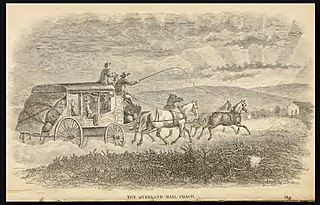
Butterfield Overland Mail was a stagecoach service in the United States operating from 1858 to 1861. It carried passengers and U.S. Mail from two eastern termini, Memphis, Tennessee, and St. Louis, Missouri, to San Francisco, California. The routes from each eastern terminus met at Fort Smith, Arkansas, and then continued through Indian Territory (Oklahoma), Texas, New Mexico, Arizona, Mexico, and California ending in San Francisco. On March 3, 1857, Congress authorized the U.S. postmaster general, at that time Aaron V. Brown, to contract for delivery of the U.S. mail from St. Louis to San Francisco. Prior to this, U.S. Mail bound for the Far West had been delivered by the San Antonio and San Diego Mail Line since June 1857.

Pusch Ridge is the most prominent feature in the Pusch Ridge Wilderness Area of the Santa Catalina Mountains, managed by the Coronado National Forest north of Tucson, Arizona, in the United States.

Arivaca is an unincorporated community in Pima County, Arizona, United States. It is located 11 miles (18 km) north of the Mexican border and 35 miles (56 km) northwest of the port of entry at Nogales. The European-American history of the area dates back at least to 1695, although the community was not founded until 1878. Arivaca has the ZIP code 85601. The 85601 ZIP Code Tabulation Area had a population of 909 at the 2000 census.
Rancho Valle de San Felipe was a 9,972-acre (40.36 km2) Mexican land grant in present-day San Diego County, California given in 1846 by Governor Pío Pico to Felipe Castillo. The grant was located in the San Felipe Valley in the Laguna Mountains east of present-day Julian.

The Altar Valley is a 45-mile (72 km) long north–south valley, trending slightly northeast from Sasabe, Arizona on the Mexico border to the Avra Valley west of the Tucson Mountains. It is delimited by Arizona State Route 86, from east-to-west on the north separating it from the Avra Valley which then trends northwesterly, merging into the plains and drainage of the Santa Cruz River.

Southern Emigrant Trail, also known as the Gila Trail, the Kearny Trail, Southern Trail and the Butterfield Stage Trail, was a major land route for immigration into California from the eastern United States that followed the Santa Fe Trail to New Mexico during the California Gold Rush. Unlike the more northern routes, pioneer wagons could travel year round, mountain passes not being blocked by snows; however, it had the disadvantage of summer heat and lack of water in the desert regions through which it passed in New Mexico Territory and the Colorado Desert of California. Subsequently, it was a route of travel and commerce between the eastern United States and California. Many herds of cattle and sheep were driven along this route and it was followed by the San Antonio-San Diego Mail Line in 1857–1858 and then the Butterfield Overland Mail from 1858 to 1861.
The Butterfield Overland Mail was a transport and mail delivery system that employed stagecoaches that travelled on a specific route between St. Louis, Missouri and San Francisco, California and which passed through the New Mexico Territory. It was created by the United States Congress on March 3, 1857, and operated until March 30, 1861. The route that was operated extended from where the ferry across the Colorado River to Fort Yuma Station, California was located, through New Mexico Territory via Tucson to the Rio Grande and Mesilla, New Mexico then south to Franklin, Texas, midpoint on the route. The New Mexico Territory mail route was divided into two divisions each under a superintendent. Tucson was the headquarters of the 3rd Division of the Butterfield Overland Mail Company. Franklin Station in the town of Franklin,, was the headquarters of the 4th Division.
Mowry City is a ghost town first in Dona Anna County, then Grant County and finally in Luna County, New Mexico, United States, approximately 25 miles (40 km) north of Deming. Originally it was the crossing point of Cooke's Wagon Road on the Mimbres River. Mowry City was formerly the location of Rio Mimbres, a stop on the San Antonio-San Diego Mail Line, and Miembre's River Station, a stagecoach stop on the Butterfield Overland Mail and later stagecoach routes. The town lasted from 1859 until the arrival of the railroad in southern New Mexico in 1881.

Agua Caliente in Maricopa County, Arizona on the border with Yuma County, is a place north of the Gila River near Hyder, Arizona. Named 'Santa Maria del Agua Caliente' in 1744 by Father Jacob Sedelmayer. In 1775, Father Francisco Garces used the current short form. The location was the site of a resort established at the site of nearby hot springs. Agua Caliente, a name derived from Spanish meaning "hot water", received its name from nearby hot springs which were originally used by the local Indigenous population.

San Felipe Valley is an inland valley of the Peninsular Ranges, located in eastern San Diego County, California. Most of the valley is protected within the San Felipe Valley Wildlife Area.

Brawley Wash is an ephemeral stream, tributary to the Santa Cruz River, located in Pima County. Its source is in the Altar Valley between the Sierrita and Coyote Mountains at 31°58′20″N111°23′29″W, at the confluence of the Altar and Alambre washes along Arizona State Route 286. It flows north-north east through the Altar Valley and turns north as it enters Avra Valley near Robles Junction where Arizona State Route 86 crosses the streambed. The wash traverses the Avra Valley between the Roskruge Mountains and the Tucson Mountains. It joins the Santa Cruz east of the Samaniego Hills of the Silver Bell Mountains. The wash is known as the Los Robles Wash near its junction with the Santa Cruz approximately six miles west of Avra and Interstate 10.
Vallecito, in San Diego County, California, is an oasis of cienegas and salt grass along Vallecito Creek and a former Kumeyaay settlement on the edge of the Colorado Desert in the Vallecito Valley. Its Spanish name is translated as "little valley". Vallecito was located at the apex of the gap in the Carrizo Badlands created by Carrizo Creek and its wash in its lower reach, to which Vallecito Creek is a tributary. The springs of Vallecito, like many in the vicinity, are a product of the faults that run along the base of the Peninsular Ranges to the west.

Dragoon Springs is an historic site in what is now Cochise County, Arizona, at an elevation of 4,925 feet (1,501 m). The name comes from a nearby natural spring, Dragoon Spring, to the south in the Dragoon Mountains at 5,148 feet (1,569 m). The name originates from the 3rd U.S. Cavalry Dragoons who battled the Chiricahua, including Cochise, during the Apache Wars. The Dragoons established posts around 1856 after the Gadsden Purchase made the area a U.S. territory.
Texas Hill Station is a site of a later Butterfield Overland Mail stagecoach station. It was one of several built in 1859 to increase the number of water stops and team changes along the drier and hotter sections of the route and was located about 2 miles east of Texas Hill.


