Tucson Estates, Arizona

Last updated

Tucson Estates, Arizona
CDP
Pima County Incorporated and Unincorporated areas Tucson Estates highlighted.svg
Location in Pima County and the state of Arizona
Usa edcp location map.svg
Red pog.svg
Tucson Estates, Arizona
Location in the United States
Coordinates: 32°10′51″N111°6′35″W / 32.18083°N 111.10972°W / 32.18083; -111.10972
Country United States
State Arizona
County Pima
Area
[1]
  Total12.72 sq mi (32.96 km2)
  Land12.72 sq mi (32.96 km2)
  Water0.00 sq mi (0.00 km2)
Elevation
2,648 ft (807 m)
Population
 (2020)
  Total12,069
  Density948.45/sq mi (366.20/km2)
Time zone UTC-7 (MST (no DST))
FIPS code 04-77035
GNIS feature ID0025245

Tucson Estates is a census-designated place (CDP) in Pima County, Arizona, United States. The population was 9,755 at the 2000 census.

Contents

Geography

Tucson Estates is located at 32°10′51″N111°6′35″W / 32.18083°N 111.10972°W / 32.18083; -111.10972 (32.180867, -111.109661). [2]

According to the United States Census Bureau, the CDP has a total area of 35.1 square miles (90.9 km2), all land.

The census area is made up of several housing developments. The primary ones are

Demographics

Historical population
CensusPop.Note
1980 2,814
1990 2,662−5.4%
2000 9,755266.5%
2010 12,19225.0%
2020 12,069−1.0%
source: [3]

At the 2000 census there were 9,755 people, 4,222 households, and 2,883 families living in the CDP. The population density was 278.0 inhabitants per square mile (107.3/km2). There were 4,891 housing units at an average density of 139.4 per square mile (53.8/km2). The racial makeup of the CDP was 83.8% White, 0.7% Black or African American, 1.7% Native American, 0.3% Asian, <0.1% Pacific Islander, 11.5% from other races, and 2.0% from two or more races. 23.7% of the population were Hispanic or Latino of any race. [4] Of the 4,222 households 19.2% had children under the age of 18 living with them, 57.2% were married couples living together, 7.4% had a female householder with no husband present, and 31.7% were non-families. 27.1% of households were one person and 15.8% were one person aged 65 or older. The average household size was 2.31 and the average family size was 2.77.

The age distribution was 19.4% under the age of 18, 5.0% from 18 to 24, 20.1% from 25 to 44, 25.5% from 45 to 64, and 30.0% 65 or older. The median age was 50 years. For every 100 females, there were 91.5 males. For every 100 females age 18 and over, there were 90.5 males.

The median household income was $36,183 and the median family income was $40,212. Males had a median income of $30,833 versus $24,071 for females. The per capita income for the CDP was $18,771. About 6.2% of families and 7.7% of the population were below the poverty line, including 10.6% of those under age 18 and 5.9% of those age 65 or over.

Related Research Articles

<span class="mw-page-title-main">Avra Valley, Arizona</span> CDP in Pima County, Arizona

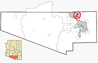
Avra Valley is a census-designated place (CDP) in Pima County, Arizona, United States. The population was 6,050 at the 2010 census, up from 5,038 in 2000.

<span class="mw-page-title-main">Corona de Tucson, Arizona</span> CDP in Pima County, Arizona

Corona de Tucson is a census-designated place (CDP) in Pima County, Arizona, United States. The population was 9,240 at the 2020 census, an increase of 1036% from the 2000 population of 813.

<span class="mw-page-title-main">Flowing Wells, Arizona</span> CDP in Pima County, Arizona

Flowing Wells is a census-designated place (CDP) in Pima County, Arizona, United States. It is a suburb of Tucson. The population was 16,419 at the 2010 census.

<span class="mw-page-title-main">Littletown, Arizona</span> CDP in Pima County, Arizona

Littletown was a census-designated place (CDP) in Pima County, Arizona, United States. The population was 1,010 at the 2000 census. The area was annexed into Tucson in 2017.

<span class="mw-page-title-main">Picture Rocks, Arizona</span> CDP in Pima County, Arizona

Picture Rocks is a census-designated place (CDP) in Pima County, Arizona, United States, home of the Tucson artifacts. The population was 9,551 at the 2020 United States census.

<span class="mw-page-title-main">Three Points, Arizona</span> CDP in Arizona, United States

Three Points is a census-designated place (CDP) in Pima County, Arizona, United States. The population was 5,581 at the 2010 census.

<span class="mw-page-title-main">Tortolita, Arizona</span> Former CDP in Arizona, United States

Tortolita was a census-designated place (CDP) in Pima County, Arizona, United States. The population was 3,740 at the 2000 census. Tortolita was situated between the growing incorporated towns of Oro Valley and Marana with most of the area previously part of the CDP having been annexed by the two towns during the 2000s. The remaining parts of the CDP that have not been annexed continue to be unincorporated portions of Pima County.

<span class="mw-page-title-main">Vail, Arizona</span> CDP in Pima County, Arizona

Vail is a census-designated place (CDP) in Pima County, Arizona, United States. It is 24 miles (39 km) southeast of Tucson. The population was 10,208 at the 2010 census, up from 2484 in the 2000 census. The area is known for the nearby Colossal Cave, a large cave system, and the Rincon Mountains District of Saguaro National Park, a top tourism spot within Arizona.

<span class="mw-page-title-main">Valencia West, Arizona</span> CDP in Pima County, Arizona

Valencia West is a census-designated place (CDP) in Pima County, Arizona, United States. The population was 9,355 at the 2010 census, a 293% increase over the population of 2,380 in 2000.

<span class="mw-page-title-main">Chuichu, Arizona</span> CDP in Pinal County, Arizona

Chuichu is a census-designated place (CDP) in Pinal County, Arizona, United States. The population was 308 at the 2020 census. It is the northernmost traditional village on the Tohono O'odham Nation reservation.

<span class="mw-page-title-main">Stanfield, Arizona</span> CDP in Pinal County, Arizona

Stanfield is a census-designated place (CDP) in Pinal County, Arizona, United States. The population was 651 at the 2000 census. Shamrock Farms operates a farm in Stanfield.

<span class="mw-page-title-main">Crystal Springs, Florida</span> CDP in Florida, United States

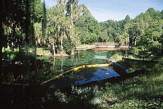
Crystal Springs is a hydrological spring and a census-designated place (CDP) in Pasco County, Florida, United States. The population was 1,175 at the 2000 census.

<span class="mw-page-title-main">Nanawale Estates, Hawaii</span> Census-designated place in Hawaii, U.S.

Nānāwale Estates is a census-designated place (CDP) in Hawaiʻi County, Hawaii, United States located in the District of Puna. The population was 1,426 at the 2010 census, up from 1,073 at the 2000 census.

<span class="mw-page-title-main">Lakewood Shores, Illinois</span> Census-designated place in Illinois, United States

Lakewood Shores is a census-designated place (CDP) in Will County, Illinois, United States. The population was 665 at the 2020 census.

Blacklick Estates is a census-designated place (CDP) in Franklin County, Ohio, United States: partly in Madison Township and partly in Truro Township. As of the 2020 census the population was 8,990.

<span class="mw-page-title-main">Eaton Estates, Ohio</span> Census-designated place in Ohio, United States

Eaton Estates is an unincorporated community and census-designated place (CDP) in Lorain County, Ohio, United States. The population was 1,155 at the 2020 census.

<span class="mw-page-title-main">Lyons Switch, Oklahoma</span> Census-designated place in Oklahoma, United States

Lyons Switch is a census-designated place (CDP) in Adair County, Oklahoma, United States. The population was 288 at the 2010 census.

<span class="mw-page-title-main">Peter, Utah</span> Census-designated place in Utah, United States

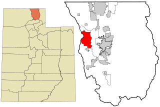
Petersboro is a census-designated place (CDP) on the west-central edge of Cache County, Utah, United States. The population was 324 at the 2010 census. It is included in the Logan, Utah-Idaho (partial) Metropolitan Statistical Area.

<span class="mw-page-title-main">Ipswich (CDP), Massachusetts</span> Census-designated place in Massachusetts, United States

Ipswich is a census-designated place (CDP) located in the town of Ipswich in Essex County, Massachusetts, United States. The population was 4,222 at the 2010 census.

<span class="mw-page-title-main">Mechanic Falls (CDP), Maine</span> Census-designated place in Maine, United States

Mechanic Falls is a census-designated place (CDP) in the town of Mechanic Falls in Androscoggin County, Maine, United States. The population of the CDP was 2,237 at the 2010 census, out of a total town population of 3,031.

References

  1. "2020 U.S. Gazetteer Files". United States Census Bureau. Retrieved October 29, 2021.
  2. "US Gazetteer files: 2010, 2000, and 1990". United States Census Bureau. February 12, 2011. Retrieved April 23, 2011.
  3. "Census of Population and Housing (1790–2000)". U.S. Census Bureau . Retrieved July 17, 2010.
  4. "U.S. Census website". United States Census Bureau . Retrieved January 31, 2008.