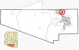
Rillito is a census-designated place (CDP) [1] in Pima County, Arizona, United States, surrounded by the town of Marana. The largest business in the community is Arizona Portland Cement and the community has had a post office since the 1920s. There is a regional park and recreation center (Rillito Vista Community Center) in the middle of the community. Rillito has the ZIP Code of 85654; in 2000, the population of the 85654 ZIP Code Tabulation Area was 148. [2]
The entire CDP is served by Marana High School and Marana Middle School. For elementary education, the portion of Rillito lying north of Avra Valley Road is served by Marjorie W. Estes Elementary School [3] and the portion south of Avra Valley Road by the elementary division of Twin Peaks K-8 School. [4] All of these schools are part of the Marana Unified School District.
For fire protection and emergency medical services, certain portions of the CDP are served by the Picture Rocks Fire & Medical District while other parts of served by the Northwest Fire District. [5] Law enforcement services are provided by the Pima County Sheriff's Department's Tucson Mountain District, with the portion of Rillito lying north of Avra Valley Road served by Beat 1 and the portion lying south of Avra Valley Road served by Beat 2. [6]

Tucson is a city in and the county seat of Pima County, Arizona, United States, and is home to the University of Arizona. It is the second-largest city in Arizona behind Phoenix, with a population of 542,629 in the 2020 United States census, while the population of the entire Tucson metropolitan statistical area (MSA) is 1,043,433. The Tucson MSA forms part of the larger Tucson-Nogales combined statistical area. Both Tucson and Phoenix anchor the Arizona Sun Corridor. The city is 108 miles (174 km) southeast of Phoenix and 60 mi (100 km) north of the United States–Mexico border.

Pima County is a county in the south central region of the U.S. state of Arizona. As of the 2020 census, the population was 1,043,433, making it Arizona's second-most populous county. The county seat is Tucson, where most of the population is centered. The county is named after the Pima Native Americans, also known as Tohono O'odham, who are indigenous to this area.

Avra Valley is a census-designated place (CDP) in Pima County, Arizona, United States. The population was 6,050 at the 2010 census, up from 5,038 in 2000.

Casas Adobes is an unincorporated community and census-designated place (CDP) located in the northern metropolitan area of Tucson, Arizona. The population was 66,795 at the 2010 census. Casas Adobes is situated south and southwest of the town of Oro Valley, and west of the community of Catalina Foothills.

Flowing Wells is a census-designated place (CDP) in Pima County, Arizona, United States. It is a suburb of Tucson. The population was 16,419 at the 2010 census.

Marana is a town that mostly lies in Pima County with a small portion in Pinal County, in the U.S. state of Arizona. It is located northwest of Tucson, Arizona. As of the 2020 census, the population of the town was 51,908.

Tanque Verde is a suburban unincorporated community in Pima County, Arizona, United States, northeast of Tucson. The population was 16,195 at the 2000 census. For statistical purposes, the United States Census Bureau has defined Tanque Verde as a census-designated place (CDP).
Tortolita was a census-designated place (CDP) in Pima County, Arizona, United States. The population was 3,740 at the 2000 census. Tortolita was situated between the growing incorporated towns of Oro Valley and Marana with most of the area previously part of the CDP having been annexed by the two towns during the 2000s. The remaining parts of the CDP that have not been annexed continue to be unincorporated portions of Pima County.

The Tucson Mountains are a minor mountain range west of Tucson, Arizona, United States. The Tucson Mountains, including Wasson Peak, are one of four notable mountain ranges surrounding the Tucson Basin. The Santa Catalina Mountains lie to the northeast, the Rincon Mountains are to the east of Tucson, and the Santa Rita Mountains lie to the south. Additionally, the Sierrita Mountains lie due south, the Roskruge Mountains lie to the west across Avra Valley, the Silver Bell Mountains lie to the northwest, and the Tortolita Mountains lie to the north across the Santa Cruz Valley.
Amphitheater Public Schools, also known as Amphi or District 10, is the third largest public school district in Tucson, Arizona, in terms of enrollment, with about 13,500 students and a staff of about 2000 employees Amphi was established on July 3, 1893. With its headquarters in Flowing Wells, presently serves segments of North Tucson, Casas Adobes, Catalina Foothills, and the communities of Oro Valley, eastern Tortolita, and Catalina northwest of the city.
Pima Community College (PCC) is a public community college in Pima County, Arizona. It serves the Tucson metropolitan area with a community college district consisting of five campuses, four education centers, and several adult education learning centers. It provides traditional and online instruction for over 144 programs. The college also offers workforce training, non-credit personal interest classes and post-baccalaureate certificates. PCC is one of the largest multi-campus community colleges in the United States, with relative ranking varying between fourth and tenth largest. PCC is accredited by the Higher Learning Commission.

Marana Regional Airport, also known as Marana Northwest Regional Airport or Avra Valley Airport, is a non-towered, general aviation airport about 15 miles northwest of Tucson, Arizona in Marana a town in Pima County, Arizona, United States. In 1999, the airport was purchased from Pima County by the town of Marana.

Area code 520 is a telephone area code in the North American Numbering Plan (NANP) for the U.S. state of Arizona. The numbering plan area comprises Tucson and most of the southeastern part of the state.

Marana Unified School District (MUSD) is an above average, public school district located in Marana, AZ, comprising 17 schools in Pima County, Arizona. It has its headquarters in Marana. It has 12,293 students in grades PK, K-12 with a student-teacher ratio of 19 to 1, about 650 teachers. According to state test scores, 42% of students are at least proficient in math and 42% in reading. Founded in the early 1920s, MUSD's boundaries include 550 square miles (1,400 km2) of land.
Arizona's 6th congressional district is a congressional district located in the U.S. state of Arizona and encompasses all of Greenlee County, most of Cochise County, and parts of Pima County, Pinal County and Graham County. Most of its population resides in suburbs of Tucson, including Oro Valley, Marana, Green Valley, and Vail. The district is currently represented by Republican Juan Ciscomani. It was one of 18 districts that would have voted for Joe Biden in the 2020 presidential election had they existed in their current configuration while being won or held by a Republican in 2022.

The Silver Bell Mountains are a northwest–southeast trending mountain range in north–central Pima County, Arizona. The range lies 14 miles (23 km) west of Marana, Arizona, located on Interstate-10, northwest of Tucson.
The West Silver Bell Mountains are a small 10 mile (16 km) long mountain range of south-central Arizona, United States. The range lies in the north-central arid Sonoran Desert; the Madrean Sky Islands region of southeast Arizona, around Tucson is adjacent to the southeast.
The Flowing Wells Unified School District is a unified school district headquartered at 1556 West Prince Road, Tucson, Arizona. It serves much of Flowing Wells, as well as bits of Tucson, Marana, Cortaro, Casas Adobes, & unnamed, unincorporated parts of Pima County. The district does practice open enrollment for students outside of district boundaries, provided said students maintain certain academic performance.
Pima County Natural Resources, Parks and Recreation is the agency within Pima County, Arizona that manages the natural resources, parks, and recreation offerings within Pima County including Tucson, AZ.
The Loop is a network of shared-use paths in metropolitan Tucson, Arizona maintained by Pima County. Once complete it will comprise 131 miles (211 km) of paved trails dedicated to cyclist, pedestrian, and equestrian use. By 2014, the network was 85% complete, with over one hundred miles in place. Pima County estimates the Loop is used by an average of 2,000 visitors each weekday and more than 5,000 on weekends.
![]() Media related to Rillito, Arizona at Wikimedia Commons
Media related to Rillito, Arizona at Wikimedia Commons
