Picture Rocks, Arizona

Last updated

Picture Rocks, Arizona
CDP
Pima County Incorporated and Unincorporated areas Picture Rocks highlighted.svg
Location in Pima County and the state of Arizona
Usa edcp location map.svg
Red pog.svg
Picture Rocks, Arizona
Location in the United States
Coordinates: 32°19′51″N111°13′47″W / 32.33083°N 111.22972°W / 32.33083; -111.22972
CountryUnited States
State Arizona
County Pima
Area
[1]
  Total70.86 sq mi (183.52 km2)
  Land70.84 sq mi (183.49 km2)
  Water0.01 sq mi (0.03 km2)
Elevation
2,080 ft (634 m)
Population
 (2020)
  Total9,551
  Density134.82/sq mi (52.05/km2)
Time zone UTC-7 (MST (no DST))
FIPS code 04-55300
GNIS feature ID 1866990

Picture Rocks is a census-designated place (CDP) in Pima County, Arizona, United States, home of the Tucson artifacts. The population was 9,551 at the 2020 United States census.

Contents

Geography

Picture Rocks is located at 32°19′51″N111°13′47″W / 32.33083°N 111.22972°W / 32.33083; -111.22972 (32.330735, -111.229652). [2]

According to the United States Census Bureau, the CDP has a total area of 55.6 sq mi (144 km2), of which 55.6 sq mi (144 km2) is land and 0.1 sq mi (0.26 km2) (0.09%) is water.

Demographics

Historical population
CensusPop.Note
2020 9,551
U.S. Decennial Census [3]

At the 2000 census there were 8,139 people and 2,883 households residing in the CDP. The population density was 146.4 inhabitants per square mile (56.5/km2). There were 3,088 housing units at an average density of 55.6/sq mi (21.5/km2). The racial makeup of the CDP was 89.6% White, 0.6% Black or African American, 1.4% Native American, 0.4% Asian, 0.1% Pacific Islander, 5.4% from other races, and 2.6% from two or more races. 13.8% of the population were Hispanic or Latino of any race. [4] Of the 2,883 households 38.6% had children under the age of 18 living with them, 59.2% were married couples living together, 10.6% had a female householder with no husband present, and 24.3% were non-families. 18.4% of households were one person and 4.2% were one person aged 65 or older. The average household size was 2.82 and the average family size was 3.20.

The age distribution was 30.0% under the age of 18, 6.3% from 18 to 24, 31.3% from 25 to 44, 24.5% from 45 to 64, and 7.9% 65 or older. The median age was 36 years. For every 100 females, there were 102.6 males. For every 100 females age 18 and over, there were 99.8 males.

The median household income was $39,534 and the median family income was $43,026. Males had a median income of $30,752 versus $21,513 for females. The per capita income for the CDP was $17,132. About 4.3% of families and 7.5% of the population were below the poverty line, including 10.9% of those under age 18 and 1.8% of those age 65 or over.

Related Research Articles

<span class="mw-page-title-main">Tucson Estates, Arizona</span> CDP in Arizona, United States

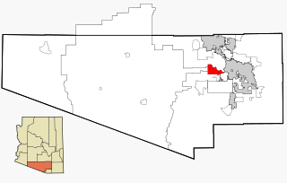
Tucson Estates is a census-designated place (CDP) in Pima County, Arizona, United States. The population was 9,755 at the 2000 census.

Au Sable Township is a charter township of Iosco County in the U.S. state of Michigan. The population was 2,206 at the 2020 census.

<span class="mw-page-title-main">Richland, Mississippi</span> City in Mississippi, United States

Richland is a city in Rankin County, Mississippi, United States. The population was 7,137 at the 2020 census. A suburb of Jackson, Richland is part of the Jackson Metropolitan Statistical Area, and is located southeast of the state capital.

Iron Post is a census-designated place (CDP) in Mayes County, Oklahoma, United States. The population was 117 at the 2000 census, but had declined to 92 in 2010, a loss of more than 21 percent.

<span class="mw-page-title-main">Collinsville, Virginia</span> CDP in Virginia, United States

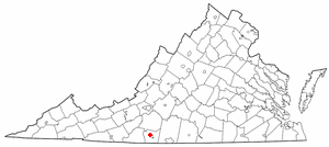
Collinsville is a census-designated place (CDP) in Henry County, Virginia, United States. The population was 7,335 at the 2010 census, which was down from the 7,777 reported in 2000. It is part of the Martinsville Micropolitan Statistical Area. Collinsville is also where the administration building and county courthouse of Henry County are located.

<span class="mw-page-title-main">Markham, Washington</span> CDP in Washington, United States

Markham is a census-designated place (CDP) in Grays Harbor County, Washington, United States. The population was 111 at the 2010 census.

<span class="mw-page-title-main">East Hill-Meridian, Washington</span> Former CDP in Washington, United States

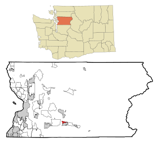
East Hill-Meridian is a former census-designated place (CDP) in King County, Washington. The population was 29,878 at the time of the 2010 census. The majority of the census area is now within the limits of Kent and Renton.

<span class="mw-page-title-main">Machias, Washington</span> CDP in Washington, United States

Machias is a census-designated place (CDP) in Snohomish County, Washington, United States. The population was 1,178 at the 2010 census.

<span class="mw-page-title-main">North Sultan, Washington</span> CDP in Washington, United States

North Sultan is a census-designated place (CDP) in Snohomish County, Washington, United States. The population was 264 at the 2010 census.

<span class="mw-page-title-main">Three Lakes, Washington</span> CDP in Washington, United States

Three Lakes is a census-designated place (CDP) in Snohomish County, Washington, United States. The population was 3,184 at the 2010 census.

<span class="mw-page-title-main">Woods Creek, Washington</span> CDP in Washington, United States

Woods Creek is a census-designated place (CDP) in Snohomish County, Washington, United States. The population was 5,589 at the 2010 census.

<span class="mw-page-title-main">Deming, Washington</span> CDP in Washington, United States

Deming is a census-designated place (CDP) in Whatcom County, Washington, United States, along the Nooksack River. It is named for its first postmaster, George Deming. The community population was 353 at the 2010 census.

<span class="mw-page-title-main">Eschbach, Washington</span> CDP in Washington, United States

Eschbach is a census-designated place (CDP) in Yakima County, Washington, United States. The population was 415 at the 2010 census.

<span class="mw-page-title-main">Gilbert Creek, West Virginia</span> CDP in West Virginia, United States

Gilbert Creek is a census-designated place (CDP) in Mingo County, West Virginia, United States. The population was 1,090 at the 2010 census. The community takes its name from nearby Gilbert Creek.

<span class="mw-page-title-main">Daniels, West Virginia</span> Census-designated place in West Virginia, United States

Daniels is a census-designated place (CDP) in Raleigh County, West Virginia, United States. The population was 1,881 at the 2010 census.

<span class="mw-page-title-main">Boaz, Wisconsin</span> Village in Wisconsin, United States

Boaz is a village in Richland County, Wisconsin, United States. According to the 2010 census, the population of the village was 156.

Alpine Northeast is a census-designated place in Lincoln County, Wyoming, United States. The population was 246 at the 2020 census.

<span class="mw-page-title-main">Auburn, Wyoming</span> Census-designated place in Wyoming, United States

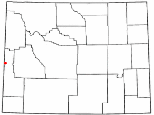
Auburn is a census-designated place (CDP) in Lincoln County, Wyoming, United States. As of the 2020 census, the CDP population was 375.

<span class="mw-page-title-main">Madawaska (CDP), Maine</span> Census-designated place in Maine, United States

Madawaska is a census-designated place (CDP) comprising the main village within the town of Madawaska in Aroostook County, Maine, United States. The population of the CDP was 2,967 at the 2010 census, out of a population of 4,035 for the entire town.

<span class="mw-page-title-main">Skowhegan (CDP), Maine</span> CDP in Maine, United States

Skowhegan is a census-designated place (CDP) in the town of Skowhegan in Somerset County, Maine, United States. The population was 6,404 at the 2020 census.

References

  1. "2020 U.S. Gazetteer Files". United States Census Bureau. Retrieved October 29, 2021.
  2. "US Gazetteer files: 2010, 2000, and 1990". United States Census Bureau. February 12, 2011. Retrieved April 23, 2011.
  3. "Census of Population and Housing". Census.gov. Retrieved June 4, 2016.
  4. "U.S. Census website". United States Census Bureau . Retrieved January 31, 2008.

32°19′51″N111°13′47″W / 32.330735°N 111.229652°W / 32.330735; -111.229652