
The Entrada Sandstone is a formation in the San Rafael Group found in the U.S. states of Wyoming, Colorado, northwest New Mexico, northeast Arizona, and southeast Utah. Part of the Colorado Plateau, this formation was deposited during the Jurassic Period sometime between 180 and 140 million years ago in various environments, including tidal mudflats, beaches, and sand dunes. The Middle Jurassic San Rafael Group was dominantly deposited as ergs in a desert environment around the shallow Sundance Sea.
The Opata are an Indigenous people in Mexico. Opata territory, the "Opatería" in Spanish, encompasses the mountainous northeast and central part of the state of Sonora, extending to near the border with the United States. Historically, they included several subtribes, including the Eudeve, Teguima, and Jova peoples.

Ópata is either of two closely related Uto-Aztecan languages, Teguima and Eudeve, spoken by the Opata people of northern central Sonora in Mexico and Southeast of Arizona in the United States. It was believed to be dead already in 1930, and Carl Sofus Lumholtz reported the Opata to have become "Mexicanized" and lost their language and customs already when traveling through Sonora in the 1890s.
Arizpe is a small town and the municipal seat of the Arizpe Municipality in the north of the Mexican state of Sonora. It is located at 30°20'"N 110°09'"W. The area of the municipality is 2,806.78 sq.km. The population in 2005 was 2,959 of which 1,743 lived in the municipal seat as of the 2000 census.
Bacadéhuachi is a village in Bacadéhuachi Municipality in the northeast of the Mexican state of Sonora. It is 269 kilometers northeast of the state capital, Hermosillo.
Bacanora is a small town in Bacanora Municipality in the east of the Mexican state of Sonora. It is located at the geographical coordinates of 28°59′N109°24′W.

Bacoachi is a small town in Bacoachi Municipality in the north of the Mexican state of Sonora. The area of the municipality is 487 square miles (1,260.65 km2) and the population was 1,456 in 2005, with 924 inhabitants residing in the municipal seat. The elevation of the municipal seat is 4,429 feet above sea level.
Sahuaripa is a town in the Mexican state of Sonora, municipality of Sahuaripa. The area is 5,694.4 km². with a population of 5,792 in 2005. The town and municipal seat had a population of 3,807 in 2000.
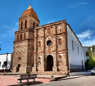
Banámichi is a small town in the north of the Mexican state of Sonora. It serves as the seat for the surrounding municipality of the same name. Geographical coordinates are 30°01′N110°13′W.
Bavispe is a small town and a municipality in the northeast part of the Mexican state of Sonora.
Huásabas is the municipal seat of Huásabas Municipality in the northeast of the Mexican state of Sonora. The municipal area is 711.17 km² (274.58 mi²) with a population of 966 registered in 2000. Most of the inhabitants live in the municipal seat.
Nácori Chico is a small town in Nácori Chico Municipality in the east of the Mexican state of Sonora.
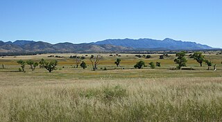
The San Rafael Valley is a high intermontane grass valley in eastern Santa Cruz County, Arizona. The valley is bounded to the west by the Patagonia Mountains, to the north and northeast by the Canelo Hills and to the east by the Huachuca Mountains in Cochise County. The valley forms the headwaters of the Santa Cruz River which flows south into Sonora, Mexico just east of the historic Lochiel townsite.
The 1st Battalion of Native Cavalry, California Volunteers was a cavalry battalion in the Union Army during the American Civil War. Recruits were largely drawn from the Californio population, though its ranks included Yaqui and Mission Indians as well as immigrants from Mexico, Hispano America and Europe. In addition to its ethnic makeup, the Battalion is also considered unusual for being one of the few lancer units in the United States Army.

The Canelo Hills are a range of low mountains or hills in eastern Santa Cruz County, Arizona. The range consists of a series of northwest–southeast trending ridges extending from the Sonoita Creek valley southwest of Sonoita to the Parker Canyon Lake area in southwest Cochise County, Arizona. The Canelo Hills merge with the Huachuca Mountains to the southeast. The San Rafael Valley lies to the southwest of the range and the Patagonia Mountains lie to the west across the Harshaw Creek valley. The Canelo Hills Cienega Reserve and the ghost town of Canelo, Arizona, are located on the eastern side of the hills.
Juan Bautista Nentvig was a priest born in Glatz, Germany on March 28, 1713. He was active in the Pimaria Alta where he worked with the various Piman Tribes, including the Upper Pima and Opata. He began there in 1752. He documented their life and customs extensively, although some of his writings of the medicinal values of native plants appear to be somewhat exaggerated.
Juan Banderas was the leader of the Yaqui during part of the Yaqui Wars, specifically from 1825 until 1833.

The San Rafael Ranch, formerly known as the Greene Ranch, is a historic cattle ranch located in the San Rafael Valley about a mile and a half north of Lochiel, Arizona, near the international border with Sonora, Mexico.


