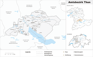
Thun District was one of the 25 administrative districts in the canton of Bern, Switzerland. Its capital was the municipality of Thun. The district had an area of 285 km² and consists of 27 municipalities:
Skookumchuck Rapids Provincial Park is a provincial park in British Columbia, Canada, located on the Shuswap River just below the outlet of Mabel Lake. This park was established as a result of the Okanagan-Shuswap Land and Resource Management Plan.
Bynumville is an unincorporated community in eastern Chariton County, Missouri, United States. It is located approximately twelve miles north of Salisbury on Route 129.

Guácimo is the sixth canton in the province of Limón in Costa Rica. The canton covers an area of 576.48 km², and has a population of 37,549. Its capital city is also called Guácimo.
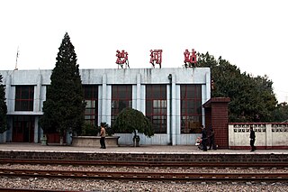
Shahe railway station is a railway station in Beijing. Passenger services ceased on 15 September 2012.

Murray River is a municipality that holds community status in Prince Edward Island, Canada. It is located in Kings County.
Tam Nông, is a rural district of Phú Thọ Province in the Northeast region of Vietnam. As of 2003, the district had a population of 82,370. The district covers an area of 156 km². The district capital lies at Hưng Hóa.
Ostrožno is a local community of the City Municipality of Celje in central-eastern Slovenia. Until 1982, Ostrožno was an independent settlement.
The Studenci District is a city district of the City Municipality of Maribor in northeastern Slovenia. Notable landmarks include the Maribor Bridge, which crosses the Drava River.

Artavan is a small village in the Vayots Dzor Province of Armenia, probably at one time a fief of Tatev. In the proximity is an 18th-century bridge and old cemetery.

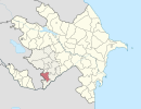
Dəvədaşı is a village in the Kalbajar Rayon of Azerbaijan.

Kamieńczyce is a village in the administrative district of Gmina Kazimierza Wielka, within Kazimierza County, Świętokrzyskie Voivodeship, in south-central Poland. It lies approximately 6 kilometres (4 mi) south-west of Kazimierza Wielka and 72 km (45 mi) south of the regional capital Kielce.
Wicko is a village in Lębork County, Pomeranian Voivodeship, in northern Poland. It is the seat of the gmina called Gmina Wicko. It lies approximately 16 kilometres (10 mi) north-west of Lębork and 74 km (46 mi) north-west of the regional capital Gdańsk.
Judziki is a village in the administrative district of Gmina Ełk, within Ełk County, Warmian-Masurian Voivodeship, in northern Poland.

Sijarina is a village in the municipality of Medveđa, Serbia. According to the 2002 census, the village has a population of 359 people. Of these, 272 were ethnic Albanians, 73 were Serbs, 9 Romani, 3 Montenegrins, and 2 others.

Sendići is a village in the municipality of Višegrad, Bosnia and Herzegovina.
Šehovina is a village in the municipality of Nevesinje, Republika Srpska, Bosnia and Herzegovina.

The Oksem, Dongsolbatsem, Sesolbatsem and Namsolbatsem Islands Important Bird Area comprises a group of small islands, with a collective area of about 50 ha, in the north-eastern Yellow Sea, lying close to the western coast of North Korea. The site has been identified by BirdLife International as an Important Bird Area (IBA) because it supports breeding endangered black-faced spoonbills.
Guinns Creek is a stream in Pike County of eastern Missouri. It is a tributary of Bryants Creek.
Bocharov Ruchey is the summer residence of the President of Russia. It is located in the Tsentralny City District of Sochi, Russia.